
Vila Boa, Goiás
Encyclopedia
| Vila Boa | |
|---|---|
| State | Goiás Goiás Goiás is a state of Brazil, located in the central part of the country. The name Goiás comes from the name of an indigenous community... |
| Coordinates: | 15°02′01"S 47°02′52"W |
| Area: | 1,060.0 km² |
| Population: | 4,198 (IBGE 2005) |
| Population density: | 3.96 inhab/km² (2007) |
| Elevation: | 640m above sea level |
| Postcode (CEP): | 73825-000 |
| IBGE statistical microregion: | 012 Entorno de Brasília |
| Became a city: | 1993 |
| Mayor: | Waldir Gualberto de Brito |
| Distance to Goiânia Goiânia -Climate:The city has a tropical wet and dry climate with an average temperature of . There's a wet season, from October to April, and a dry one, from May to September. Annual rainfall is around 1,520 mm.... : |
365 km. |
| Website: | none |
Town
A town is a human settlement larger than a village but smaller than a city. The size a settlement must be in order to be called a "town" varies considerably in different parts of the world, so that, for example, many American "small towns" seem to British people to be no more than villages, while...
and municipality
Municipality
A municipality is essentially an urban administrative division having corporate status and usually powers of self-government. It can also be used to mean the governing body of a municipality. A municipality is a general-purpose administrative subdivision, as opposed to a special-purpose district...
in northeastern Goiás
Goiás
Goiás is a state of Brazil, located in the central part of the country. The name Goiás comes from the name of an indigenous community...
state, Brazil
Brazil
Brazil , officially the Federative Republic of Brazil , is the largest country in South America. It is the world's fifth largest country, both by geographical area and by population with over 192 million people...
.
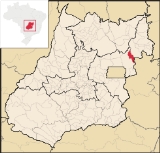
Location
Vila Boa is located on the extreme northeast limit of the Entorno de Brasília microregion. The nearest major population center is FormosaFormosa, Goiás
Formosa is a city and municipality located in the state of Goiás, Brazil, approximately 80 kilometers east of Brasília. The population was 90,247 in a total area of 5,806.89 km² . Formosa is known for its waterfalls and natural beauty...
, which is 95 km. to the southeast. It forms boundaries with:
- west and south: FormosaFormosa, GoiásFormosa is a city and municipality located in the state of Goiás, Brazil, approximately 80 kilometers east of Brasília. The population was 90,247 in a total area of 5,806.89 km² . Formosa is known for its waterfalls and natural beauty...
- east and north: Flores de GoiásFlores de GoiásFlores de Goiás is a small town and municipality in northeastern Goiás state, Brazil.-Geography:Located in the Vão do Paranã statistical micro-region, Flores has boundaries with Buritis, Sítio d'Abadia, Vila Boa, Alvorada do Norte, Iaciara, Nova Roma, São João d'Aliança, Formosa and Alto Paraíso...
The distance to state capital, Goiânia
Goiânia
-Climate:The city has a tropical wet and dry climate with an average temperature of . There's a wet season, from October to April, and a dry one, from May to September. Annual rainfall is around 1,520 mm....
, is 365 km. Highway connections from Goiânia
Goiânia
-Climate:The city has a tropical wet and dry climate with an average temperature of . There's a wet season, from October to April, and a dry one, from May to September. Annual rainfall is around 1,520 mm....
are made by BR-153 / Anápolis
Anápolis
Anápolis is the third largest city in the State of Goiás in Brazil. It lies in the center of a rich agricultural region and has become a leader in food processing and pharmaceutical plants.-Location and population:...
/ GO-060 / Alexânia
Alexânia
Alexânia is a small town and municipality in central Goiás state, Brazil. Alexânia is known for its alleged extraterrestrial sightings in the late sixties and early seventies. The Areias River passes through the municipality.-Location:...
/ Sobradinho
Sobradinho, Brasília
Sobradinho is an Administrative Region of the Federal District of Brazil. It is grouped as a satellite city of the Brazilian capital, Brasília. The area is 569.37 km² and it is located 22.1 km. northeast of Brasília...
/ BR-020 / BR-030 / Formosa
Formosa, Goiás
Formosa is a city and municipality located in the state of Goiás, Brazil, approximately 80 kilometers east of Brasília. The population was 90,247 in a total area of 5,806.89 km² . Formosa is known for its waterfalls and natural beauty...
/ BR-020 / Bezerra
Bezerra
Bezerra is a surname:People bearing it include:*Juan Bautista de Anza Bezerra Nieto , Novo-Spanish explorer*Edir Macedo Bezerra *Eliana Michaelichen Bezerra *Rico Bezerra...
(district of Formosa). For the complete list of distances see Distâncias Rodoviárias
History
Vila Boa was once a district (1988) of FormosaFormosa, Goiás
Formosa is a city and municipality located in the state of Goiás, Brazil, approximately 80 kilometers east of Brasília. The population was 90,247 in a total area of 5,806.89 km² . Formosa is known for its waterfalls and natural beauty...
, and for years was just a small village with a gas station and a few houses on the main road to Salvador
Salvador, Bahia
Salvador is the largest city on the northeast coast of Brazil and the capital of the Northeastern Brazilian state of Bahia. Salvador is also known as Brazil's capital of happiness due to its easygoing population and countless popular outdoor parties, including its street carnival. The first...
. It is 95 kilometres northeast of Formosa
Formosa, Goiás
Formosa is a city and municipality located in the state of Goiás, Brazil, approximately 80 kilometers east of Brasília. The population was 90,247 in a total area of 5,806.89 km² . Formosa is known for its waterfalls and natural beauty...
. It has grown rapidly with the arrival of farmers from the south of the country in search of inexpensive land to plant soybeans and raise cattle. In 1992 it was dismembered from Formosa and raised to municipal status.
The economy
The economy is based on agriculture (rice, coffee, sugarcane, and corn), cattle raising (34,000 head in 2006), services, public administration, and small transformation industries.Agricultural data 2006
- Farms: 217
- Total area: 94,002 ha.
- Area of permanent crops: 343 ha.
- Area of perennial crops: 3,497 ha.
- Area of natural pasture: 50,586 ha.
- Area of woodland and forests: 34,131 ha.
- Persons dependent on farming: 850
- Number of tractors: 85 IBGE
Health and education
- Higher education: none
- Adult literacy rate: 77.2% (2000) (national average was 86.4%)
- Hospitals: 1 with 13 beds (2007)
- Infant mortality rate: 28.9 (2000) (national average was 33.0).
- Human Development IndexHuman Development IndexThe Human Development Index is a composite statistic used to rank countries by level of "human development" and separate "very high human development", "high human development", "medium human development", and "low human development" countries...
: 0.674 - State ranking: 226 (out of 242 municipalities in 2000)
- National ranking: 3,389 (out of 5,507 municipalities in 2000)