
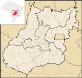
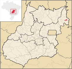
Buritinópolis
Encyclopedia
| Buritinópolis | |
|---|---|
| State | Goiás Goiás Goiás is a state of Brazil, located in the central part of the country. The name Goiás comes from the name of an indigenous community... |
| Geographical Coordinates: | 14°28′29"S 46°24′54"W |
| Area: | 268.1 km² |
| Population: | 3,442(IBGE 2007) |
| Elevation: | 550m |
| Postcode (CEP): | 73975-000 |
| IBGE statistical microregion: | 018 Vão do Paranã |
| Became a city: | 1993 |
| Mayor: | João Oreste Soares de Oliveira |
| Distance to Goiânia Goiânia -Climate:The city has a tropical wet and dry climate with an average temperature of . There's a wet season, from October to April, and a dry one, from May to September. Annual rainfall is around 1,520 mm.... : |
466 km. |
| Website: | n/a |
Town
A town is a human settlement larger than a village but smaller than a city. The size a settlement must be in order to be called a "town" varies considerably in different parts of the world, so that, for example, many American "small towns" seem to British people to be no more than villages, while...
and municipality
Municipality
A municipality is essentially an urban administrative division having corporate status and usually powers of self-government. It can also be used to mean the governing body of a municipality. A municipality is a general-purpose administrative subdivision, as opposed to a special-purpose district...
in eastern Goiás
Goiás
Goiás is a state of Brazil, located in the central part of the country. The name Goiás comes from the name of an indigenous community...
state, Brazil
Brazil
Brazil , officially the Federative Republic of Brazil , is the largest country in South America. It is the world's fifth largest country, both by geographical area and by population with over 192 million people...
. It is the poorest municipality in the state.
Location
Buritinópolis is located in the Vão do Paranã statistical micro-region in the area near SimolândiaSimolândia
Simolândia is a small town and municipality in northeast Goiás state, Brazil.-Location and Geography:Simolândia is situated in the northeast of Goiás, at kilometer 250 of the important BR-020 . It forms boundaries with Posse, Alvorada do Norte and Buritinópolis...
and Alvorada do Norte
Alvorada do Norte
Alvorada do Norte is a small town and municipality in northeastern Goiás state, Brazil. It is an important commercial center on the Brasília-Salvador highway.-Location:...
. It is close to the important BR-020 highway, which connects Brasília
Brasília
Brasília is the capital city of Brazil. The name is commonly spelled Brasilia in English. The city and its District are located in the Central-West region of the country, along a plateau known as Planalto Central. It has a population of about 2,557,000 as of the 2008 IBGE estimate, making it the...
with Salvador. Neighboring municipalities are Posse
Posse, Goiás
Posse is a small town and municipality in northeastern Goiás state, Brazil.-Geography:It is located northeast of Brasília, 24 km. from the state boundary with Bahia, on interstate highway BR-020...
,
Simolândia
Simolândia
Simolândia is a small town and municipality in northeast Goiás state, Brazil.-Location and Geography:Simolândia is situated in the northeast of Goiás, at kilometer 250 of the important BR-020 . It forms boundaries with Posse, Alvorada do Norte and Buritinópolis...
, Alvorada do Norte
Alvorada do Norte
Alvorada do Norte is a small town and municipality in northeastern Goiás state, Brazil. It is an important commercial center on the Brasília-Salvador highway.-Location:...
, Mambaí
Mambaí
Mambaí is a city in eastern Goiás state, Brazil. It is the easternmost city in that state.-Geography:Mambaí is one of the most isolated cities in the state of Goiás. It lies in the Vão do Paranã statistical micro-region less than 20 kilometers from the border with the state of Bahia. It is 61...
, and Damianópolis
Damianópolis
Damianópolis is a small town and municipality in eastern Goiás state, Brazil. The population was 3,597 in a total area of 415.3 km².-Location:...
. The distance to Goiânia
Goiânia
-Climate:The city has a tropical wet and dry climate with an average temperature of . There's a wet season, from October to April, and a dry one, from May to September. Annual rainfall is around 1,520 mm....
is 466 km. Highway connections are made by BR-153 / Anápolis
Anápolis
Anápolis is the third largest city in the State of Goiás in Brazil. It lies in the center of a rich agricultural region and has become a leader in food processing and pharmaceutical plants.-Location and population:...
/ Alexânia
Alexânia
Alexânia is a small town and municipality in central Goiás state, Brazil. Alexânia is known for its alleged extraterrestrial sightings in the late sixties and early seventies. The Areias River passes through the municipality.-Location:...
/ BR-060 / Planaltina
Planaltina
Planaltina is one of the administrative districts of the Federal District of Brazil, with an area of 1,534 kmª and a population of 147,114 in 2000, of whom 134,663 were classified as urban and 12,451 as rural...
/ Formosa
Formosa, Goiás
Formosa is a city and municipality located in the state of Goiás, Brazil, approximately 80 kilometers east of Brasília. The population was 90,247 in a total area of 5,806.89 km² . Formosa is known for its waterfalls and natural beauty...
/ BR-020 / Simolândia
Simolândia
Simolândia is a small town and municipality in northeast Goiás state, Brazil.-Location and Geography:Simolândia is situated in the northeast of Goiás, at kilometer 250 of the important BR-020 . It forms boundaries with Posse, Alvorada do Norte and Buritinópolis...
/ GO-236.
Demographics
- Geometric Growth Rate 1996/2007: 0.17%
- Population density: 12.84 inhab/km²
- Urban population: 1,842
- Rural population: 1,600
Economy
The main economic activities are cattle raising for meat and farming, especially soybeans and corn. Most of the inhabitants either have no work or are employed in subsistence farming. In 2007 there were 15 commercial units and no banks. The absence of investments in the town leaves the inhabitants without the chance of a job and many, mainly the young, leave the town to try to find a job that would allow them to survive. There were no hospitals (2007. There were 100 automobiles in 2007, which was 1 automobile for every 34 inhabitants.Agricultural data 2006
- Farms: 310
- Total area: 6,772 ha.
- Area of permanent crops: 116 ha.
- Area of perennial crops: 578 ha.
- Area of pasture: 3,750 ha.
- Area of woodland and forests: 1,814 ha.
- Persons dependent on farming: 1,000
- Cattle herd: 27,848
Health and education
- Literacy rate: 71.9 in 2000.
- Infant mortality rate in 2000: 50.06
- Hospitals: none
- Schools: 8 with 1,240 students
- Ranking on the United Nations Municipal Human Development IndexHuman Development IndexThe Human Development Index is a composite statistic used to rank countries by level of "human development" and separate "very high human development", "high human development", "medium human development", and "low human development" countries...
: 0.603 (in the lower tiers) - State ranking: 242/242 (the worst in the state)
- National ranking: 4,612/5,507
In Buritinópolis, there is no bank branch, no restaurant, and no hotel. The two supermarkets are comparable to the little grocery stores in the slums of the large urban centers and the bars can only provide income for their owners. The agricultural activities provide few jobs since the small rural landowners practice subsistence farming and the large landowners opt for extensive cattle raising, which requires few workers.
Urban erosion is a worry for all. It has already destroyed a large part of the main avenue that runs parallel to BR-020, the highway that cuts the city in two. With no money to build drains and pave the streets on both side of the highway, the city government is waiting for help from the state government.
Notes
See also
- List of municipalities in Goiás
- Microregions of Goiás
- Vão do Paranã MicroregionVão do Paranã MicroregionThe Vão do Paranã is a statistical micro-region created by IBGE in northeastern Goiás state, Brazil.*Population: 102,927 inhabitants *Cities: 12...