

Microregions in Goiás
Encyclopedia
Goiás
Goiás is a state of Brazil, located in the central part of the country. The name Goiás comes from the name of an indigenous community...
is divided into 18 statistical microregions by the Instituto Brasileiro de Geografia e Estatístic (IBGE). These have no administrative function but are used only for statistics. The total area of the state is 341,289 km2 and the population is 5,450,303 as of 2007.
Thirty seven percent of the population--2,032,305--resides in the Goiânia Microregion
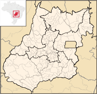
Goiânia Microregion
The Goiânia Microregion is a region in central Goiás state, Brazil. It includes 17 municipalities with a population of 2,032,305 in a total area of 6,848.00 km²....
and 17.6%--960,141-- of the population resides in the Entorno de Brasília Microregion. The GDP of the state of Goiás was R$ 50,536 billion in 2005, the last year data was gathered.
Microregions of Goiás
| Microregion | Area {km²) | % of the state area {km²) | Inhabitants in 1980 | Inhabitants in 2007 | % of the state population | GDP (R$1,000.00) in 2005 | % of state GDP (R$1,000.00) in 2005 |
|---|---|---|---|---|---|---|---|
| Anápolis Anápolis Microregion The Anápolis Microregion is a region of central Goiás state, Brazil, including municipalities surrounding the city of Anápolis. For a map see *Population: 517,221 inhabitants *Cities: 19*Total Area: 8,386.80 km²... |
8,387 | 2.4 | 350,317 | 517,221 | 9.4 | 3,851,580 | 7.6 |
| Anicuns Anicuns Microregion The Anicuns Microregion is a geographical division in the state of Goiás, Brazil. It is made up of 13 municipalities located near Anicuns, a small city and municipality west of Goiânia... |
5,483 | 1.6 | 101,813 | 100,759 | 1.8 | 694,825 | 1.3 |
| Aragarças Aragarças Microregion The Aragarças Microregion is a geographical division in Goiás state, Brazil. It consists of 7 municipalities located near Aragarças in western Goiás. For a map see -Important Data :*Population: 53,541*Cities: 7*Total Area: 11,091.90 km²... |
11,092 | 3.2 | 48,346 | 53,541 | 0.9 | 322,068 | 0.6 |
| Catalão Catalão Microregion The Catalão Microregion is a statistical microregion created by IBGE in south-eastern Goiás state, Brazil.*Population: 131.741 inhabitants *Cities: 11*Total Area: 15,238.60 km²... |
15,239 | 4.4 | 90,159 | 133,156 | 2,4 | 3,352,117 | 6.6 |
| Ceres Ceres Microregion The Ceres Microregion is located in north-central Goiás state, Brazil. It includes 22 cities with a total population of 215,820 inhabitants . The total area is 13,224.40 km² and the population density is 16.32 inhab/km². The most important cities are Ceres and Goianésia.The most populous... |
13,224 | 3.8 | 190,414 | 215,820 | 3.9 | 1,432,288 | 2.8 |
| Chapada dos Veadeiros Chapada dos Veadeiros Microregion The Chapada dos Veadeiros Microregion is an IBGE statistical region in north-central Goiás state, Brazil. It includes 8 cities with a population of 60,267 in a total area of 21,476 km²... |
21,476 | 6.3 | 39,814 | 60,267 | 1,1 | 408,374 | 0.8 |
| Entorno de Brasília | 38,212 | 11.2 | 259,804 | 960,141 | 17,6 | 4,764,348 | 9.4 |
| Goiânia Goiânia Microregion The Goiânia Microregion is a region in central Goiás state, Brazil. It includes 17 municipalities with a population of 2,032,305 in a total area of 6,848.00 km².... |
6,848 | 2.0 | 863,065 | 2,032,305 | 37.2 | 18,510,977 | 36.6 |
| Iporá Iporá Microregion The Iporá Microregion is a geographical region in central-western Goiás state, Brazil. The most important city is Iporá. For a map see -Important Data :*Population: 58,845 *Cities: 10*Total Area: 7,096.60 km²... |
7,097 | 2.0 | 66,349 | 58,845 | 1.0 | 351,519 | 0.6 |
| Meia Ponte Meia Ponte Microregion The Meia Ponte Microregion is a statistical region of Goiás state, Brazil created by the IBGE . It is located south of the state capital, Goiânia, and includes 21 cities with a total population of 338,147 inhabitants . The total area is 21,229.00 km² and the population density is 14.39 inhab/km²... |
21,229 | 6.2 | 232,807 | 338,147 | 6.2 | 4,033,284 | 7.9 |
| Pires do Rio Pires do Rio Microregion The Pires do Rio Microregion is a statistical region of south-central Goiás state, Brazil. The most important city is Pires do Rio. The area includes 10 cities with a population of 90,327 in an area of 9,449.80 km²... |
9,450 | 2.7 | 69,081 | 90,327 | 1.6 | 788,161 | 1.5 |
| Porangatu Porangatu Microregion The Porangatu Microregion is a statistical region created by IBGE in north-central Goiás state, Brazil. The most important city is Porangatu... |
35,287 | 10.3 | 198,609 | 220,794 | 4.0 | 1,874,454 | 3,7 |
| Quirinópolis Quirinópolis Microregion The Quirinópolis Microregion is a region in south Goiás state, Brazil. It includes 8 municipalities with a population of 95,094 and a total area of 16,117.60 km². The population density was 5.89 km²... |
16,118 | 4.7 | 86,242 | 95,094 | 1.7 | 1,520,155 | 3.0 |
| Rio Vermelho Rio Vermelho Microregion The Rio Vermelho Microregion is a geographical region in central Goiás state, Brazil. The most important city is Goiás, also known as Goiás Velho. The Rio Vermelho, a tributary of the Araguaia River flows through the region... |
20,277 | 5.9 | 87,039 | 86,362 | 1,5 | 663,131 | 1.3 |
| São Miguel do Araguaia São Miguel do Araguaia Microregion The São Miguel do Araguaia Microregion is a geographical region in northwest Goiás state, Brazil. There are 7 cities in the region with a total population of 68,888 inhabitants in an area of 24,471.80 km²... |
24,472 | 7.2 | 61,463 | 76,625 | 1.4 | 696,474 | 1.3 |
| Sudoeste de Goiás | 56,293 | 16.5 | 224,540 | 397,387 | 7.3 | 5,497,824 | 10.8 |
| Vale do Rio dos Bois Vale do Rio dos Bois Microregion Vale do Rio dos Bois Microregion is a statistical region in central Goiás state, Brazil. It lies west of the state capital, Goiânia-Important Data :*Population: 107,317 inhabitants*Cities: 13*Total Area: 13,653.60 km²... |
13,654 | 4.0 | 82,414 | 107,317 | 1.9 | 1,336,258 | 2.6 |
| Vão do Paranã Vão do Paranã Microregion The Vão do Paranã is a statistical micro-region created by IBGE in northeastern Goiás state, Brazil.*Population: 102,927 inhabitants *Cities: 12... |
17,453 | 5.1 | 68,849 | 102,927 | 1.8 | 438,245 | 0.8 |