
Shimen Dam
Encyclopedia
Shimen Dam is an embankment dam
crossing the Dahan River in Taoyuan County, Taiwan
. Serving mainly for municipal water supply and flood control, the dam creates Shimen Reservoir in the mountains south of Longtan. The construction plan was created in 1938 under Japanese rule
, but was not implemented immediately because of the start of World War II
. The dam was the largest in Taiwan when construction ended in 1964.
Each day, Shimen supplies 1.4 million tonnes of water to residences and industry and 1.8 million tonnes of water to agriculture in Taoyuan County, Taiwan|Taoyuan County and New Taipei City. It is integral to the water supply/regulation system of northern Taiwan. The dam cost NT
$4.85 billion to construct.
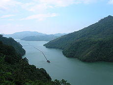
.jpg) The dam site lies in a steep canyon of the Dahan (大漢) River near the aboriginal town of Fusing
The dam site lies in a steep canyon of the Dahan (大漢) River near the aboriginal town of Fusing
, at the head of a 763 km² (294.6 sq mi) catchment area. The canyon, with walls up to 500 metres (1,640.4 ft) high, was formerly home to the summer villa of Chiang K'ai-shek. The historic arched Amuping Stone Bridge and a nearby Earth God shrine
, among other landmarks, were also covered by the Shimen Reservoir as it filled.
Before the dam was built in the 1950s, the flow of the Dahan River below the dam was copious enough in the rainy season to make it navigable from the coast to points in Taipei
and Tamsui.
In August 2004, Typhoon Aere
hit northern Taiwan, dumping 973 millimetres (38.3 in) of rain on the region. The resultant erosion caused by rainfall caused landslides to carry up to 20 million tons of debris into the Shimen Reservoir. Although turbidity levels in the reservoir usually measure roughly 40 NTU. and the water filtration plant can handle up to 3,000 NTU, it was clogged by the sediment in the water which reached a peak of 70,000-120,000 NTU. As a result, homes, businesses, and farms that relied on Shimen Reservoir had their water supply cut off. For several days, these customers had to subsist on trucked-in water.
Also in August 2004, the entry fee to the dam, NT$80/person, was lifted, allowing free public access to the dam facilities.
In 1994, the Amuping bridge and shrine became visible again because of record low waters in Shimen Reservoir. Since then, the shrine has been covered by steady siltation of reservoir waters, though the bridge remains intact and is visible during low water.
In early 2008, the Taiwanese EPA announced a plan to spend NT$200 million ($6.16 million USD) to control nutrient levels in Shimen and three other large reservoirs in the region. High nutrient levels heavily affect water quality, causing eutrophication
. The four reservoirs provide water for nearly ten million people, which is half of the country's population.
.
In July 1956, work on the dam commenced. The upstream cofferdam for the Shimen Dam was then constructed, reaching a height of 70 metres (229.7 ft). One of the largest cofferdams built for its time, it also pioneered the use of roller-compacted concrete
in gravity dam building. The roller-compacted concrete was used to build the core of the cofferdam, while the rest of the dam was completed by an embankment of coarse, pit-run aggregate.
With the upstream cofferdam completed, construction was able to proceed; the dam structure was completed in June 1964 and reservoir filling was completed later.
 The Shimen Dam is a curved concrete and earthfill gravity dam 330 metres (1,082.7 ft) long and 130 metres (426.5 ft) high.
The hydroelectric power plant of the dam is located on its west side, while a six-bay spillway
section is located shortly to the east. The spillways are fed by water through a series of tainter gate
s; they end in a hydraulic jump
that dissipates water energy.
Intakes for the water supply system are located on the upstream face, and consist of five outlets leading to a water treatment plant.
All water released into the river from the dam flows into its forebay, formed by a combination concrete gravity and earth-fill dam directly downstream from Shimen. (A forebay is a dam located downstream from a larger dam in order to regulate irregular water releases.
)
Due to irregular and dangerous sediment patterns in the Shimen Reservoir, with sediment travelling in invisible underwater plumes, a solution clearly had to be found. As a result, a large sediment monitoring system is in place. The first of the systems was installed before 2005 at two points in the lake. The system, called "Vertical Profiling System" or "YSI 6600EDS", measures a series of water quality factors by depth, with intervals of 5 metres (16.4 ft). The turbidity
, chlorophyll
content, pH
level, and dissolved oxygen levels are sent to the operator of the dam every three hours. A future plan for the system is to help record algae
growth, preventing hypoxic
events in the water and benefiting fish and other wildlife.
.
Water drawn from the reservoir feeds to twenty-eight districts of northern Taiwan, supplying municipal water to about 3.4 million people. The reservoir also contributes water to many agricultural and industrial users. An old-growth forest, the 49420 acres (200 km²) "Chi-Lan Formosan Cedar Forest", lies upstream of Shimen Reservoir. Runoff from the forest area feeds the reservoir, and the two sources of water supply are responsible for supplying nearly half of the population throughout five northern counties.
Annually, the reservoir produces 80000 kilograms (176,369.8 lb) of commercial fish. Fish production generates an annual revenue of NT$29.33 million.
The steep, mountainous upper reaches of the Dahan River have long been a flooding hazard. When first built, the Shimen Dam was capable of protecting against large floods, but sedimentation has since reduced this capacity.
The dam and reservoir attract roughly 160,000 visitors per year, especially during high water releases, and overall are "a direct contribution to the rapid expansion of the island's economy".
, is being extensively logged. Although environmentalists and others have attempted to set limits on logging, results were not successful and logging continues. As logging occurs, large swathes of bare ground are exposed to more rapid erosion
, leading to landslides and mudflows that may cloud the Shimen Reservoir. As after Typhoon Aere, a high sediment content in the lake potentially can clog the water filtration works, cutting off domestic water supply. The sediment monitoring systems positioned in the lake are only used for monitoring, and as a result, have no means to control sediment flow.
Embankment dam
An embankment dam is a massive artificial water barrier. It is typically created by the emplacement and compaction of a complex semi-plastic mound of various compositions of soil, sand, clay and/or rock. It has a semi-permanent waterproof natural covering for its surface, and a dense, waterproof...
crossing the Dahan River in Taoyuan County, Taiwan
Taiwan
Taiwan , also known, especially in the past, as Formosa , is the largest island of the same-named island group of East Asia in the western Pacific Ocean and located off the southeastern coast of mainland China. The island forms over 99% of the current territory of the Republic of China following...
. Serving mainly for municipal water supply and flood control, the dam creates Shimen Reservoir in the mountains south of Longtan. The construction plan was created in 1938 under Japanese rule
Taiwan under Japanese rule
Between 1895 and 1945, Taiwan was a dependency of the Empire of Japan. The expansion into Taiwan was a part of Imperial Japan's general policy of southward expansion during the late 19th century....
, but was not implemented immediately because of the start of World War II
World War II
World War II, or the Second World War , was a global conflict lasting from 1939 to 1945, involving most of the world's nations—including all of the great powers—eventually forming two opposing military alliances: the Allies and the Axis...
. The dam was the largest in Taiwan when construction ended in 1964.
Each day, Shimen supplies 1.4 million tonnes of water to residences and industry and 1.8 million tonnes of water to agriculture in Taoyuan County, Taiwan|Taoyuan County and New Taipei City. It is integral to the water supply/regulation system of northern Taiwan. The dam cost NT
New Taiwan dollar
The New Taiwan dollar , or simply Taiwan dollar, is the official currency of the Taiwan Area of the Republic of China since 1949, when it replaced the Old Taiwan dollar...
$4.85 billion to construct.
History and site
Fusing, Taoyuan
Fusing is an aboriginal township in eastern Taoyuan County, Taiwan Province of the Republic of China. Fusing is home to many Atayal tribes. Lalashan , is a major feature of Fusing, and the Shimen Reservoir, formed by Shimen Dam, is a popular nearby site....
, at the head of a 763 km² (294.6 sq mi) catchment area. The canyon, with walls up to 500 metres (1,640.4 ft) high, was formerly home to the summer villa of Chiang K'ai-shek. The historic arched Amuping Stone Bridge and a nearby Earth God shrine
Shrine
A shrine is a holy or sacred place, which is dedicated to a specific deity, ancestor, hero, martyr, saint, daemon or similar figure of awe and respect, at which they are venerated or worshipped. Shrines often contain idols, relics, or other such objects associated with the figure being venerated....
, among other landmarks, were also covered by the Shimen Reservoir as it filled.
Before the dam was built in the 1950s, the flow of the Dahan River below the dam was copious enough in the rainy season to make it navigable from the coast to points in Taipei
Taipei
Taipei City is the capital of the Republic of China and the central city of the largest metropolitan area of Taiwan. Situated at the northern tip of the island, Taipei is located on the Tamsui River, and is about 25 km southwest of Keelung, its port on the Pacific Ocean...
and Tamsui.
In August 2004, Typhoon Aere
Typhoon Aere
The name Aere has been used to name two tropical cyclones in the northwestern Pacific Ocean. The name was contributed by the United States of America, and is the Marshallese word for 'storm'....
hit northern Taiwan, dumping 973 millimetres (38.3 in) of rain on the region. The resultant erosion caused by rainfall caused landslides to carry up to 20 million tons of debris into the Shimen Reservoir. Although turbidity levels in the reservoir usually measure roughly 40 NTU. and the water filtration plant can handle up to 3,000 NTU, it was clogged by the sediment in the water which reached a peak of 70,000-120,000 NTU. As a result, homes, businesses, and farms that relied on Shimen Reservoir had their water supply cut off. For several days, these customers had to subsist on trucked-in water.
Also in August 2004, the entry fee to the dam, NT$80/person, was lifted, allowing free public access to the dam facilities.
In 1994, the Amuping bridge and shrine became visible again because of record low waters in Shimen Reservoir. Since then, the shrine has been covered by steady siltation of reservoir waters, though the bridge remains intact and is visible during low water.
In early 2008, the Taiwanese EPA announced a plan to spend NT$200 million ($6.16 million USD) to control nutrient levels in Shimen and three other large reservoirs in the region. High nutrient levels heavily affect water quality, causing eutrophication
Eutrophication
Eutrophication or more precisely hypertrophication, is the movement of a body of water′s trophic status in the direction of increasing plant biomass, by the addition of artificial or natural substances, such as nitrates and phosphates, through fertilizers or sewage, to an aquatic system...
. The four reservoirs provide water for nearly ten million people, which is half of the country's population.
Construction
Funding for the dam totaled NT$4.85 billion. $21 million USD (NT$694 million) was loaned to the construction project by the United StatesUnited States
The United States of America is a federal constitutional republic comprising fifty states and a federal district...
.
In July 1956, work on the dam commenced. The upstream cofferdam for the Shimen Dam was then constructed, reaching a height of 70 metres (229.7 ft). One of the largest cofferdams built for its time, it also pioneered the use of roller-compacted concrete
Roller-compacted concrete
Roller-compacted concrete or rolled concrete is a special blend of concrete that has essentially the same ingredients as conventional concrete but in different ratios, and increasingly with partial substitution of fly ash for Portland cement. RCC is a mix of cement/fly ash, water, sand, aggregate...
in gravity dam building. The roller-compacted concrete was used to build the core of the cofferdam, while the rest of the dam was completed by an embankment of coarse, pit-run aggregate.
With the upstream cofferdam completed, construction was able to proceed; the dam structure was completed in June 1964 and reservoir filling was completed later.
Dimensions and operations
The hydroelectric power plant of the dam is located on its west side, while a six-bay spillway
Spillway
A spillway is a structure used to provide the controlled release of flows from a dam or levee into a downstream area, typically being the river that was dammed. In the UK they may be known as overflow channels. Spillways release floods so that the water does not overtop and damage or even destroy...
section is located shortly to the east. The spillways are fed by water through a series of tainter gate
Tainter gate
The Tainter gate is a type of radial arm floodgate used in dams and canal locks to control water flow. It is named for Wisconsin structural engineer Jeremiah Burnham Tainter....
s; they end in a hydraulic jump
Hydraulic jump
A hydraulic jump is a phenomenon in the science of hydraulics which is frequently observed in open channel flow such as rivers and spillways. When liquid at high velocity discharges into a zone of lower velocity, a rather abrupt rise occurs in the liquid surface...
that dissipates water energy.
Intakes for the water supply system are located on the upstream face, and consist of five outlets leading to a water treatment plant.
All water released into the river from the dam flows into its forebay, formed by a combination concrete gravity and earth-fill dam directly downstream from Shimen. (A forebay is a dam located downstream from a larger dam in order to regulate irregular water releases.
)
Due to irregular and dangerous sediment patterns in the Shimen Reservoir, with sediment travelling in invisible underwater plumes, a solution clearly had to be found. As a result, a large sediment monitoring system is in place. The first of the systems was installed before 2005 at two points in the lake. The system, called "Vertical Profiling System" or "YSI 6600EDS", measures a series of water quality factors by depth, with intervals of 5 metres (16.4 ft). The turbidity
Turbidity
Turbidity is the cloudiness or haziness of a fluid caused by individual particles that are generally invisible to the naked eye, similar to smoke in air. The measurement of turbidity is a key test of water quality....
, chlorophyll
Chlorophyll
Chlorophyll is a green pigment found in almost all plants, algae, and cyanobacteria. Its name is derived from the Greek words χλωρος, chloros and φύλλον, phyllon . Chlorophyll is an extremely important biomolecule, critical in photosynthesis, which allows plants to obtain energy from light...
content, pH
PH
In chemistry, pH is a measure of the acidity or basicity of an aqueous solution. Pure water is said to be neutral, with a pH close to 7.0 at . Solutions with a pH less than 7 are said to be acidic and solutions with a pH greater than 7 are basic or alkaline...
level, and dissolved oxygen levels are sent to the operator of the dam every three hours. A future plan for the system is to help record algae
Algae
Algae are a large and diverse group of simple, typically autotrophic organisms, ranging from unicellular to multicellular forms, such as the giant kelps that grow to 65 meters in length. They are photosynthetic like plants, and "simple" because their tissues are not organized into the many...
growth, preventing hypoxic
Hypoxia (environmental)
Hypoxia, or oxygen depletion, is a phenomenon that occurs in aquatic environments as dissolved oxygen becomes reduced in concentration to a point where it becomes detrimental to aquatic organisms living in the system...
events in the water and benefiting fish and other wildlife.
Benefits
The hydroelectric power plant at the base of the Shimen Dam uses water drawn from the Shimen Reservoir to power generators. The plant has a capacity of 400 megawatts, generating roughly 200 million kilowatt-hours of energy annually. A key factor in the electricity grid of northern Taiwan, it runs as a peaking power plantPeaking power plant
Peaking power plants, also known as peaker plants, and occasionally just "peakers," are power plants that generally run only when there is a high demand, known as peak demand, for electricity.-Peak hours:...
.
Water drawn from the reservoir feeds to twenty-eight districts of northern Taiwan, supplying municipal water to about 3.4 million people. The reservoir also contributes water to many agricultural and industrial users. An old-growth forest, the 49420 acres (200 km²) "Chi-Lan Formosan Cedar Forest", lies upstream of Shimen Reservoir. Runoff from the forest area feeds the reservoir, and the two sources of water supply are responsible for supplying nearly half of the population throughout five northern counties.
Annually, the reservoir produces 80000 kilograms (176,369.8 lb) of commercial fish. Fish production generates an annual revenue of NT$29.33 million.
The steep, mountainous upper reaches of the Dahan River have long been a flooding hazard. When first built, the Shimen Dam was capable of protecting against large floods, but sedimentation has since reduced this capacity.
The dam and reservoir attract roughly 160,000 visitors per year, especially during high water releases, and overall are "a direct contribution to the rapid expansion of the island's economy".
Environmental issues
The Formosan cedar forest upstream of and surrounding the Shimen Reservoir, said to have qualities and values of a World Heritage SiteWorld Heritage Site
A UNESCO World Heritage Site is a place that is listed by the UNESCO as of special cultural or physical significance...
, is being extensively logged. Although environmentalists and others have attempted to set limits on logging, results were not successful and logging continues. As logging occurs, large swathes of bare ground are exposed to more rapid erosion
Erosion
Erosion is when materials are removed from the surface and changed into something else. It only works by hydraulic actions and transport of solids in the natural environment, and leads to the deposition of these materials elsewhere...
, leading to landslides and mudflows that may cloud the Shimen Reservoir. As after Typhoon Aere, a high sediment content in the lake potentially can clog the water filtration works, cutting off domestic water supply. The sediment monitoring systems positioned in the lake are only used for monitoring, and as a result, have no means to control sediment flow.