Shantar Islands
Encyclopedia


Sea of Okhotsk
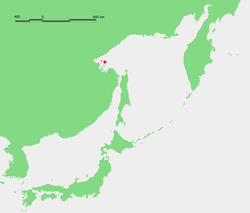
The Sea of Okhotsk is a marginal sea of the western Pacific Ocean, lying between the Kamchatka Peninsula on the east, the Kuril Islands on the southeast, the island of Hokkaidō to the far south, the island of Sakhalin along the west, and a long stretch of eastern Siberian coast along the west and...
. These islands are located close to the shores of the Siberia
Siberia
Siberia is an extensive region constituting almost all of Northern Asia. Comprising the central and eastern portion of the Russian Federation, it was part of the Soviet Union from its beginning, as its predecessor states, the Tsardom of Russia and the Russian Empire, conquered it during the 16th...
n mainland. Most islands have rugged cliffs, but they are of moderate height; the highest point in the island group is 720 metres.
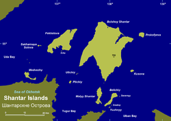
The largest island in the Shantar group is Bolshoy Shantar Island
Bolshoy Shantar Island
Bolshoy Shantar is an island in the Sea of Okhotsk, Russia. It is the main island of the Shantar Islands. Its area is 1766 km².It is about 72 km in length and 49 km in width. It has a large brackish lake in its northern end which is connected to the sea through a narrow passage....
(1790 km2). It is about 72 km in length and 49 km in width. It has a large brackish lake (Lake Bol'shoe) in its northern end which is connected to the sea through a narrow passage. Smelts (Hypomesus japonicus) and (H. olidus) are found in this lake.
Other islands include Feklistova Island
Feklistova Island
Feklistova or Feklistov Island is one of the Shantar Islands in Sea of Okhotsk. With an area of 372 km², it is the second largest in the archipelago....
(372 km2), Maly Shantar Island, (100 km2), Prokofyeva, Sakharnaya Golova, Belichiy, Kusova, Ptichiy, Utichiy, Yuzhnyy and finally Medvezhiy, which lies very close to the coast.
Administratively this island group belongs to the Khabarovsk Krai
Khabarovsk Krai
Khabarovsk Krai is a federal subject of Russia , located in the Russian Far East. It lies mostly in the basin of the lower Amur River, but also occupies a vast mountainous area along the coastline of the Sea of Okhotsk, an arm of the Pacific Ocean. The administrative center of the krai is the...
of the Russian Federation.
Ecology
There is no permanent population on the Shantar Islands, but they are often visited by commercial fishermen who use them as a base. Other economic activities undertaken on these islands are fur hunting and trapping as well as lumbering, which in the past were often done illegally. There are spruceSpruce
A spruce is a tree of the genus Picea , a genus of about 35 species of coniferous evergreen trees in the Family Pinaceae, found in the northern temperate and boreal regions of the earth. Spruces are large trees, from tall when mature, and can be distinguished by their whorled branches and conical...
forests on the largest islands. Other trees in the island taiga are the Siberian spruce
Siberian Spruce
Siberian Spruce is a spruce native to Siberia, from the Ural Mountains east to Magadan Oblast, and from the arctic tree line south to the Altay Mountains in northwestern Mongolia.-Description and uses:...
, the Dahurian larch
Dahurian Larch
Dahurian Larch, Larix gmelinii, is a species of larch native to eastern Siberia, and adjacent northeastern Mongolia, northeastern China and North Korea.-Description:...
and the mountain pine
Mountain Pine
Pinus mugo, the Mountain Pine or Mugo Pine, is a high-altitude European pine, found in the Pyrenees, Alps, Erzgebirge, Carpathians, northern Apennines and Balkan Peninsula mountains from 1,000 m to 2,200 m, occasionally as low as 200 m in the north of the range in Germany and Poland, and as high...
.
Although there is little evidence of human impact, the Shantar island ecosystem is under threat. There many endangered birds in these islands, including the Blakiston's Fish Owl
Blakiston's Fish Owl
Blakiston's Fish Owl, Bubo blakistoni, is a fish owl, a sub-group of eagle owls who specialized in hunting riparian areas. This species is a part of the family known as typical owls, Strigidae, which contains most species of owl...
, Osprey
Osprey
The Osprey , sometimes known as the sea hawk or fish eagle, is a diurnal, fish-eating bird of prey. It is a large raptor, reaching more than in length and across the wings...
, Black Stork
Black Stork
The Black Stork Ciconia nigra is a large wading bird in the stork family Ciconiidae. It is a widespread, but rare, species that breeds in the warmer parts of Europe, predominantly in central and eastern regions. This is a shy and wary species, unlike the closely related White Stork. It is seen in...
, Red-necked Grebe
Red-necked Grebe
The Red-necked Grebe is a migratory aquatic bird found in the temperate regions of the northern hemisphere. Its wintering habitat is largely restricted to calm waters just beyond the waves around ocean coasts, although some birds may winter on large lakes...
, Gyrfalcon
Gyrfalcon
The Gyrfalcon — Falco rusticolus — is the largest of the falcon species. The Gyrfalcon breeds on Arctic coasts and the islands of North America, Europe, and Asia. It is mainly resident there also, but some Gyrfalcons disperse more widely after the breeding season, or in winter.Individual vagrancy...
, Solitary Snipe
Solitary Snipe
The Solitary Snipe, Gallinago solitaria, is a small stocky wader. It breeds discontinuously in the mountains of eastern Asia, in eastern Russia, Kazakhstan Kyrgyzstan and Mongolia. Many birds are sedentary in the high mountains, or just move downhill in hard weather, but others are migratory,...
, Steller's Sea Eagle
Steller's Sea Eagle
The Steller's Sea Eagle, Haliaeetus pelagicus, is a large bird of prey in the family Accipitridae. It lives in coastal northeastern Asia and mainly preys on fish. It is, on average, the heaviest eagle in the world, at about , but often lags behind the Harpy Eagle and Philippine Eagle in other...
and the Siberian Grouse
Siberian Grouse
The Siberian Grouse, Falcipennis falcipennis, is a medium-sized grouse.It is very similar to the North American Spruce Grouse, to which it is closely related.The Siberian grouse mostly occurs in forests of spruce, fir, larch and pine...
.
The Kamchatka brown bear
Bear hunting
Bear hunting is the act of hunting bears. Bears have been hunted since prehistoric times for their meat and fur. - Details :Bears are large mammals in the order Carnivora. Although there are only eight living species of bear, they are widespread, appearing in a wide variety of habitats throughout...
(Ursus arctos beringianus), sable
Sable
The sable is a species of marten which inhabits forest environments, primarily in Russia from the Ural Mountains throughout Siberia, in northern Mongolia and China and on Hokkaidō in Japan. Its range in the wild originally extended through European Russia to Poland and Scandinavia...
and marten
Marten
The martens constitute the genus Martes within the subfamily Mustelinae, in family Mustelidae.-Description:Martens are slender, agile animals, adapted to living in taigas, and are found in coniferous and northern deciduous forests across the northern hemisphere. They have bushy tails, and large...
are common on the Shantar Islands.
The waters around these coastal islands are frozen for about eight months on a yearly average, so that they are merged with the mailand most of the year. Bearded seal
Bearded Seal
The bearded seal , also called the square flipper seal, is a medium-sized pinniped that is found in and near to the Arctic Ocean. It gets its generic name from two Greek words that refer to its heavy jaw...
s, Bowhead whale
Bowhead Whale
The bowhead whale is a baleen whale of the right whale family Balaenidae in suborder Mysticeti. A stocky dark-colored whale without a dorsal fin, it can grow to in length. This thick-bodied species can weigh to , second only to the blue whale, although the bowhead's maximum length is less than...
s and western gray whale
Gray Whale
The gray whale, Eschrichtius robustus, is a baleen whale that migrates between feeding and breeding grounds yearly. It reaches a length of about , a weight of , and lives 50–70 years. The common name of the whale comes from the gray patches and white mottling on its dark skin. Gray whales were...
s are common in the waters off the islands.
One of the most severe threats to the environment of the Shantar Islands is a proposed tidal hydroelectric power station
Tidal power
Tidal power, also called tidal energy, is a form of hydropower that converts the energy of tides into useful forms of power - mainly electricity....
, which is currently on hold for lack of funds.
History
The islands are currently uninhabited but were known to the mainland Gilyak tribes for their fishing grounds.The first recorded exploration of the Shantar Islands was in April 1640, when Russian explorer Ivan Moskvitin
Ivan Moskvitin
Ivan Yuryevich Moskvitin was a Russian explorer, presumably a native of Moscow, who led a Russian reconnaissance party to the Pacific Ocean, becoming the first Russian to reach the Sea of Okhotsk....
allegedly sailed to the mouth of the Amur River with a group of Cossack
Cossack
Cossacks are a group of predominantly East Slavic people who originally were members of democratic, semi-military communities in what is today Ukraine and Southern Russia inhabiting sparsely populated areas and islands in the lower Dnieper and Don basins and who played an important role in the...
s and spotted the Shantar Islands on the way back. Moskvitin reported his discoveries to Prince Shcherbatov, the Muscovite voivode in Tomsk
Tomsk
Tomsk is a city and the administrative center of Tomsk Oblast, Russia, located on the Tom River. One of the oldest towns in Siberia, Tomsk celebrated its 400th anniversary in 2004...
. Based on Ivan Moskvitin's account, the first Russian map of the Far East was drawn in March 1642.
The Shantar Islands were explored by Russian surveyors between 1711 and 1725.
There is a plan to declare the Shantar Islands a National Park by 2010.
Adjacent Islands
- Menshikov Island (Остров Меньшикова; Ostrov Men'shikova) 54°36′N 139°14′E lies 71 km to the east of Kusov Island's eastern shore. It is 7 km long and has a maximum width of 1.6 km.
- Reyneke Island (Остров Рейнеке; Ostrov Reyneke) 54°19′N 139°47′E lies 45 km to the southeast of Menshikov Island. It is 7 km long and has a maximum width of 1.6 km. It is located close to a landhead in the coast, separated from it by a 5 km wide sound. This island should not be confused with Reyneke Island close to Russky IslandRussky IslandRussky Island is a Russian island off Vladivostok, in the Peter the Great Gulf, Sea of Japan. It is located about 9,334 kilometres east of Moscow. The Eastern Bosphorus separates the island from the Muravyov-Amursky Peninsula....
in the Vladivostok BayVladivostokThe city is located in the southern extremity of Muravyov-Amursky Peninsula, which is about 30 km long and approximately 12 km wide.The highest point is Mount Kholodilnik, the height of which is 257 m...
.

