

Sequatchie River
Encyclopedia
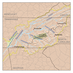
Sequatchie Valley
Sequatchie Valley is a relatively long and narrow valley in the U.S. state of Tennessee and, in some definitions, Alabama. It is generally considered to be part of the Cumberland Plateau region of the Appalachian Mountains; it was probably formed by erosion of a compression anticline, rather than...
, a large valley in the Cumberland Plateau
Cumberland Plateau
The Cumberland Plateau is the southern part of the Appalachian Plateau. It includes much of eastern Kentucky and western West Virginia, part of Tennessee, and a small portion of northern Alabama and northwest Georgia . The terms "Allegheny Plateau" and the "Cumberland Plateau" both refer to the...
in Middle Tennessee
Middle Tennessee
Middle Tennessee is a distinct portion of the state of Tennessee, delineated according to state law as the 41 counties in the Middle Grand Division of Tennessee....
.
Hydrography
The Sequatchie River's source is a massive spring which flows out of Head of Sequatchie Spring. It receives the drainage of Grassy CoveGrassy Cove
Grassy Cove is an enclosed valley in Cumberland County, Tennessee, in the southeastern United States. The valley is notable for its karst formations, which have been designated a National Natural Landmark...
, a pastoral limestone region several miles to the north from which the drainage has no surface outlet, through a spectacular series of underground passages. This cave is located in the southeastern portion of Cumberland County, and the water flowing from it is augmented by that of other sizeable springs and small streams, at least one of which provided enough flow for an early textile
Textile
A textile or cloth is a flexible woven material consisting of a network of natural or artificial fibres often referred to as thread or yarn. Yarn is produced by spinning raw fibres of wool, flax, cotton, or other material to produce long strands...
industry. The stream crosses into Bledsoe County and is at the floor of a valley that trends generally southwestward and is several miles wide. Natives of the area tend to call the portion of the Cumberland Plateau to the west of the valley the "Cumberland Mountains" or "the Plateau" and that to the east of it Walden Ridge
Walden Ridge
Walden Ridge is a mountain ridge and escarpment located in Tennessee, in the United States. It marks the eastern edge of the Cumberland Plateau and is generally considered part of it. Walden Ridge is about long, running generally north-south...
or "Wallings Ridge". The Sequatchie Valley is traversed throughout much its length by U.S. Highway 127. The first sizeable town on the Sequatchie is Pikeville
Pikeville, Tennessee
Pikeville is a city in Bledsoe County, Tennessee, United States. The population was 1,781 at the 2000 census. It is also the county seat of Bledsoe County.-Geography:...
. State Route 30, which descends Waldens Ridge into the Valley and then climbs the escarpment
Escarpment
An escarpment is a steep slope or long cliff that occurs from erosion or faulting and separates two relatively level areas of differing elevations.-Description and variants:...
back onto the plateau, crosses here.
Crossing into Sequatchie County, the stream flows into Dunlap
Dunlap, Tennessee
Dunlap is a city in Sequatchie County, Tennessee, United States. The population was 4,173 at the 2000 census. It is the county seat of Sequatchie County.Dunlap is part of the Chattanooga, TN–GA Metropolitan Statistical Area.-Geography:...
. Just north of Dunlap, U.S. 127 turns southeastward, beginning the ascent onto Walden Ridge and eventually down into Chattanooga
Chattanooga, Tennessee
Chattanooga is the fourth-largest city in the US state of Tennessee , with a population of 169,887. It is the seat of Hamilton County...
. A set of railroad tracks runs along the river from here on, testament to heavy underground coal
Coal
Coal is a combustible black or brownish-black sedimentary rock usually occurring in rock strata in layers or veins called coal beds or coal seams. The harder forms, such as anthracite coal, can be regarded as metamorphic rock because of later exposure to elevated temperature and pressure...
extraction in years past. For almost the rest of its length the Sequatchie is paralleled by State Route 28. State Route 283 also runs along the base of the Waldens Ridge escarpment for several miles. The river then enters Marion County
Marion County, Tennessee
Marion County is a county located in the U.S. state of Tennessee. As of 2000, the population was 27,776. Its county seat is Jasper.Marion County is part of the Chattanooga, TN–GA Metropolitan Statistical Area.-Geography:According to the U.S...
. The town of Whitwell
Whitwell, Tennessee
Whitwell is a city in Marion County, Tennessee, United States. The population was 1,660 at the 2000 census. It is part of the Chattanooga, TN–GA Metropolitan Statistical Area.-History:...
is just a few miles into Marion County. Below Whitwell at the small community of Sequatchie (also known as Sequachee) the Sequatchie receives the flow of the Little Sequatchie River
Little Sequatchie River
The Little Sequatchie River is a tributary of the Sequatchie River in Tennessee. Unlike its larger namesake, it does not have a spectacular large spring source but is the result of the confluence of many smaller streams in a very remote, scenic area of the Cumberland Plateau along the line...
. At Jasper
Jasper, Tennessee
Jasper is a town in Marion County, Tennessee. The population was 3,214 at the 2000 census. It is the county seat of Marion County.Jasper is part of the Chattanooga, TN–GA Metropolitan Statistical Area.-History:...
, which is slightly west of the river, is a railroad junction. East of town is the crossing of U.S. Highway 41 by Tennessee 28, and the bridge over the river. Shortly south of the Interstate 24
Interstate 24
Interstate 24 is an Interstate Highway in the Midwestern and Southeastern United States. It runs diagonally from Interstate 57 to Chattanooga, Tennessee, at Interstate 75....
bridge is the mouth of the Sequatchie into the Guntersville Lake
Guntersville Lake
Guntersville Lake is located in north Alabama between Bridgeport and Guntersville. Created by Guntersville Dam along the Tennessee River, it stretches 75 miles from Guntersville Dam to Nickajack Dam...
impoundment of the Tennessee River
Tennessee River
The Tennessee River is the largest tributary of the Ohio River. It is approximately 652 miles long and is located in the southeastern United States in the Tennessee Valley. The river was once popularly known as the Cherokee River, among other names...
.