
Santa Fé de Goiás
Encyclopedia
| Santa Fé de Goiás | |
|---|---|
| State | Goiás Goiás Goiás is a state of Brazil, located in the central part of the country. The name Goiás comes from the name of an indigenous community... |
| Area: | 1,160.8 km² |
| Population: | 4,594 (IBGE 2007) |
| Elevation: | 362m above sea level |
| Postcode (CEP): | 76265-000 |
| IBGE statistical microregion: | Rio Vermelho Microregion Rio Vermelho Microregion The Rio Vermelho Microregion is a geographical region in central Goiás state, Brazil. The most important city is Goiás, also known as Goiás Velho. The Rio Vermelho, a tributary of the Araguaia River flows through the region... |
| Became a city: | 1989 |
| Distance to Goiânia Goiânia -Climate:The city has a tropical wet and dry climate with an average temperature of . There's a wet season, from October to April, and a dry one, from May to September. Annual rainfall is around 1,520 mm.... : |
259 km. |
| Website: | none |
| Coordinates: | 15°46′12"S 51°05′45"W |
Town
A town is a human settlement larger than a village but smaller than a city. The size a settlement must be in order to be called a "town" varies considerably in different parts of the world, so that, for example, many American "small towns" seem to British people to be no more than villages, while...
and municipality
Municipality
A municipality is essentially an urban administrative division having corporate status and usually powers of self-government. It can also be used to mean the governing body of a municipality. A municipality is a general-purpose administrative subdivision, as opposed to a special-purpose district...
in west-central Goiás
Goiás
Goiás is a state of Brazil, located in the central part of the country. The name Goiás comes from the name of an indigenous community...
state, Brazil
Brazil
Brazil , officially the Federative Republic of Brazil , is the largest country in South America. It is the world's fifth largest country, both by geographical area and by population with over 192 million people...
.
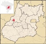
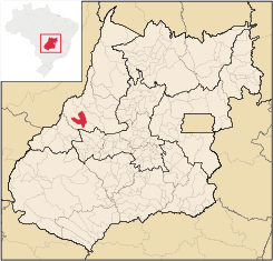
Location
Santa Fé is located almost directly west of BrasíliaBrasília
Brasília is the capital city of Brazil. The name is commonly spelled Brasilia in English. The city and its District are located in the Central-West region of the country, along a plateau known as Planalto Central. It has a population of about 2,557,000 as of the 2008 IBGE estimate, making it the...
and northwest of Goiânia
Goiânia
-Climate:The city has a tropical wet and dry climate with an average temperature of . There's a wet season, from October to April, and a dry one, from May to September. Annual rainfall is around 1,520 mm....
. The nearest town of any size is Jussara
Jussara
Jussara is a small town and municipality in Goiás state, Brazil. Jussara is a major producer of cattle for the beef market.-Location and history:Jussara is located in the region of the Vale do Araguaia, 222 kilometers from the state capital of Goiânia...
, which lies 34 km. to the southeast.
- Distance to regional center (Goiás VelhoGoiás, GoiásGoiás is a small city and municipality in the state of Goiás in Brazil. The population was 24,072 in a total area of 3,108 km² . It is the former capital of the state and preserves much of its colonial heritage...
): 132 km. - Highway connections: GO-060 / TrindadeTrindade, GoiásTrindade is a city and municipality in Goiás state, Brazil. It is famous for the religious celebrations held there in July and is now the third most important pilgrimage site in Brazil....
/ GO-326 / AnicunsAnicunsAnicuns is a small city and municipality in central Goiás state, Brazil.-Geographical Facts:Anicuns is located in the Anicuns Microregion, which includes 13 cities with a population of 103276 inhabitants in a total area of 5483.10 km²....
/ SanclerlândiaSanclerlândiaSanclerlândia is a small town and municipality in western Goiás state, Brazil. The population was 7,641 in 2005 and the total area of the municipality was 496.8 km².-Location:...
/ Novo BrasilNovo BrasilNovo Brasil is a small town and municipality in eastern Goiás state, Brazil.-Location:Novo Brasil is located east of the capital near Iporá and São Luís de Montes Belos.*Distance to the state capital: 200 km....
/ JussaraJussaraJussara is a small town and municipality in Goiás state, Brazil. Jussara is a major producer of cattle for the beef market.-Location and history:Jussara is located in the region of the Vale do Araguaia, 222 kilometers from the state capital of Goiânia...
/ BR-070 / Nova Trindade / GO-173.
Neighboring municipalities: Jussara
Jussara
Jussara is a small town and municipality in Goiás state, Brazil. Jussara is a major producer of cattle for the beef market.-Location and history:Jussara is located in the region of the Vale do Araguaia, 222 kilometers from the state capital of Goiânia...
, Britânia
Britânia
Britânia is a small town and municipality in northwestern Goiás state, Brazil. The population was 5,073 in a total area of 1461.2 km².-Municipal Boundaries:Municipal boundaries:*North: Aruanã*South: Jussara*East: Itapirapuã and Aruanã...
, Itapirapuã
Itapirapuã
Itapirapuã is a small town and municipality in the state of Goiás in Brazil. The population was 8,208 in 2007 in a total area of 2,043.7 km² . Itapirapuã is a large producer of cattle.-Location and Boundaries:...
Political Information
- Mayor: Ademar Marques de Carvalho (January 2005)
- City council: 09
- Eligible voters: 3,885 (December/2007)
In 1957 Santa Fé de Goiás became a district belonging to Goiás
Goiás, Goiás
Goiás is a small city and municipality in the state of Goiás in Brazil. The population was 24,072 in a total area of 3,108 km² . It is the former capital of the state and preserves much of its colonial heritage...
. In 1958 it was dismembered to become a district in the municipality of Jussara
Jussara
Jussara is a small town and municipality in Goiás state, Brazil. Jussara is a major producer of cattle for the beef market.-Location and history:Jussara is located in the region of the Vale do Araguaia, 222 kilometers from the state capital of Goiânia...
. In 1988 it got its municipal autonomy.
Demographic Information
- Population density: 3.96 inhab/km² (2007)
- Urban population: 3,514 (2007)
- Rural population: 1,080 (2007)
- Population growth: a gain of about 900 people since 1991
Economic Information
The economy is based on subsistence agriculture, cattle raising, services, public administration, and small transformation industries.- Industrial units: 6 (2007)
- Commercial units: 57 (2007)
- Meat-packing plant: Frigorífico Arantes Ltda
- Cattle herd: 135,000 head
- Main crops: cotton, rice, sugarcane, bananas, sesame seeds, corn, and soybeans.
- Motor vehicles: 231 automobiles, 34 trucks, and 37 pickup trucks (2007)
Education (2006)
- Schools: 5
- Classrooms: 30
- Teachers: 60
- Students: 1,314
- Higher education: none
- Adult literacy rate: 83.7% (2000) (national average was 86.4%)
Health (2003)
- Hospitals: 0
- Hospital beds: 0
- Ambulatory clinics: 2
- Doctors, nurses, dentists: 3, 1, 1 (2002)
- Infant mortality rate: 26.34 (2000) (national average was 33.0)
- MHDI: 0.713
- State ranking: 190 (out of 242 municipalities)
- National ranking: 2,744 (out of 5,507 municipalities)
See also
- List of municipalities in Goiás
- Microregions of Goiás