
San Pablo District
Encyclopedia
San Pablo is a district of the San Pedro Department, Paraguay
Paraguay
Paraguay , officially the Republic of Paraguay , is a landlocked country in South America. It is bordered by Argentina to the south and southwest, Brazil to the east and northeast, and Bolivia to the northwest. Paraguay lies on both banks of the Paraguay River, which runs through the center of the...
. It includes the village of San Pablo or San Pedro de Ycuamandiyú, which has a population of around 680, located around 330 km from the city of Asuncion
Asunción
Asunción is the capital and largest city of Paraguay.The "Ciudad de Asunción" is an autonomous capital district not part of any department. The metropolitan area, called Gran Asunción, includes the cities of San Lorenzo, Fernando de la Mora, Lambaré, Luque, Mariano Roque Alonso, Ñemby, San...
.
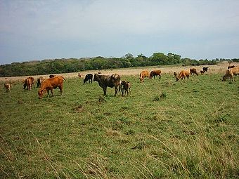
On the river Jejui Guazú, is a small district of just over 4,000 inhabitants engaged in agriculture. Its soil is suitable for agriculture and in a great proportion for livestock, too.
Geography
The district of San Pablo, is located in the center of the department San Pedro, although the region was the victim of a process of rapid deforestationDeforestation
Deforestation is the removal of a forest or stand of trees where the land is thereafter converted to a nonforest use. Examples of deforestation include conversion of forestland to farms, ranches, or urban use....
in the past, it includes one of the richest reserves of Forest
Forest
A forest, also referred to as a wood or the woods, is an area with a high density of trees. As with cities, depending where you are in the world, what is considered a forest may vary significantly in size and have various classification according to how and what of the forest is composed...
that are very profitable. They attract exploitation and marketing force due to the forests.
In the region there are areas of agricultural use and low prairies that often flood.
Surface
It has an area of 603 km², with a population of 4,351 inhabitants, and a population density of 7.22 people per square kilometer.Ports
The district has the following ports: Puerto Tayi and Puerto La Niña, which are used to trade their agricultural production, and as a means of internal communication, which communicates with the districts in the area.Communication
This district is accessible by unpaved roads and internal roads that are also unpaved, being used as secondary rural roads. The embankment roads communicate all districts with each other and other national routes.Currently, this district has public transport services between districts and regular services to the country's capital, in addition to Ciudad del Este
Ciudad del Este
Ciudad del Este is the second largest city in Paraguay and capital of Alto Paraná department, located at the Rio Paraná....
Pedro Juan Caballero
Pedro Juan Caballero
Pedro Juan Caballero may refer to:*Pedro Juan Caballero , leader of Paraguayan independence*Pedro Juan Caballero, Paraguay, a city...
Brazil
Brazil
Brazil , officially the Federative Republic of Brazil , is the largest country in South America. It is the world's fifth largest country, both by geographical area and by population with over 192 million people...
, Argentina
Argentina
Argentina , officially the Argentine Republic , is the second largest country in South America by land area, after Brazil. It is constituted as a federation of 23 provinces and an autonomous city, Buenos Aires...
and Chile
Chile
Chile ,officially the Republic of Chile , is a country in South America occupying a long, narrow coastal strip between the Andes mountains to the east and the Pacific Ocean to the west. It borders Peru to the north, Bolivia to the northeast, Argentina to the east, and the Drake Passage in the far...
.
Limits
Limits:To the north with the district of San Pedro de Ycuamandiyú, which separates the river Jejui Guazú.
To the south lies the district of Villa del Rosario.
To the east lies the district of Choré.
And to the west, the district of Antequera
Antequera District
Antequera is a district of the San Pedro Department, Paraguay with Puerto Antequera the main location at the Paraguay River. It is an agricultural region. Its location is as follows: Latitude -24.1333 Longitude -57.0833 Altitude 64 meters. Puerto Antequera has 1,632 inhabitants....
.
Hydrography
There is the river Jejui Guazú, the least polluted of the country and with beautiful white sand beaches.Climate
The climate is predominantly rainy and humid. The relative humidity is 70 to 80%. The average is 23 °C; the highest in summer is 38 °C and at least 10 °C.Education
The district has elementary schools and high school level, in which children and young people attend regularly.The illiteracy is due to extreme poverty
Extreme poverty
Extreme poverty, as defined in 1996 by Joseph Wresinski, the founder of ATD Fourth World, is:"The lack of basic security connotes the absence of one or more factors enabling individuals and families to assume basic responsibilities and to enjoy fundamental rights. The situation may become...
which makes it difficult to send children to school, which particularly affects women. The indigenous tribes also have access to primary education but with little attendance.
The working population lacks a reasonable level of qualification, which conspires against the development of the area, so it does not have trained manpower.
Language
It predominates Guarani languageGuaraní language
Guaraní, specifically the primary variety known as Paraguayan Guaraní , is an indigenous language of South America that belongs to the Tupí–Guaraní subfamily of the Tupian languages. It is one of the official languages of Paraguay , where it is spoken by the majority of the population, and half of...
which is spoken by about 80% of the inhabitants and the Castilian-Guarani (Jopara), spoken by 20% of the remaining population.
Demographics
The total number of households in the district rises to the amount of 713, of which 143 of them are in urban areas, and in rural areas there are 570, which represents the 79.94% of homes that are settled in rural areas.
According to the projection of the district's total population, by sex and by year, it includes the following details:
- By 2010, the total population is of 4,403 inhabitants, of whom 2,354 are men and 2,050 are women.
In relation to the main socio-demographic indicators, this is the following:
- Population less than 15 year-old is 43.5%.
- Average of 3.6 children per woman.
- 8.4% Illiteratation.
- Employed by the primary sector 67.6%.
- Employed by the secondary sector 6.3%.
- Employed in the tertiary sector 25.1%.
- Occupied work in the agricultural field 67.3%.
- Homes with electricity 78.4%.
- Homes with running water 41.0%.
Population
The district of San Pablo has a population of 4,351 inhabitants, of whom 2,324 are male and 2,027 are women. In percentage terms, 53.3% are male and 46.6% women.It has enabled a colony by the IBR, currently INDERT, which has an area of 6,495 hectares and with an amount of 400 lots.
Economy
It is one of the districts that has lower socio-economic indicators , however, in recent years there have been major advances, allowing the inhabitants to acquire a better quality of life.In the district of San Pablo, a large percentage of the population is poor (77.9%); having a monthly average income per family of 408,487 Guarani, and 73,834 Guarani per person.
Its economy
Economy
An economy consists of the economic system of a country or other area; the labor, capital and land resources; and the manufacturing, trade, distribution, and consumption of goods and services of that area...
is essentially agricultural and it has increased considerably thanks to the fertility of its soil and the projects of creating new colonies. Its main agricultural products are: cotton
Cotton
Cotton is a soft, fluffy staple fiber that grows in a boll, or protective capsule, around the seeds of cotton plants of the genus Gossypium. The fiber is almost pure cellulose. The botanical purpose of cotton fiber is to aid in seed dispersal....
, tobacco
Tobacco
Tobacco is an agricultural product processed from the leaves of plants in the genus Nicotiana. It can be consumed, used as a pesticide and, in the form of nicotine tartrate, used in some medicines...
, soybeans, mate
Yerba mate
Maté, yerba maté or erva maté , Ilex paraguariensis, is a species of holly native to subtropical South America in northeastern Argentina, Bolivia, southern Brazil, Uruguay and Paraguay...
, cassava
Cassava
Cassava , also called yuca or manioc, a woody shrub of the Euphorbiaceae native to South America, is extensively cultivated as an annual crop in tropical and subtropical regions for its edible starchy tuberous root, a major source of carbohydrates...
, sunflower
Sunflower
Sunflower is an annual plant native to the Americas. It possesses a large inflorescence . The sunflower got its name from its huge, fiery blooms, whose shape and image is often used to depict the sun. The sunflower has a rough, hairy stem, broad, coarsely toothed, rough leaves and circular heads...
, sour orange and sweet orange.
Municipality
The district of San Pablo’s current mayorIntendente
Governors in the various Provinces of the Viceroyalty of New Spain.In addition to governors, the following list intends to give an overview of colonial units of the provincial level; therefore it also includes some offices of similar rank, especially the intendant...
is Mr. Quentin Bernardino Gonzalez Guerrero for the election period from 2006 to 2010.
Tourism
The main tourist attraction of San Pablo are the beaches on the river Jejui Guazú, for their less polluted waters, which together with its white sand beaches make it a perfect place to cool and relax in the summer season.Getting There
Going from the city of AsuncionAsunción
Asunción is the capital and largest city of Paraguay.The "Ciudad de Asunción" is an autonomous capital district not part of any department. The metropolitan area, called Gran Asunción, includes the cities of San Lorenzo, Fernando de la Mora, Lambaré, Luque, Mariano Roque Alonso, Ñemby, San...
, Route II Marshal José Félix Estigarribia, to the city of Coronel Oviedo
Coronel Oviedo
Coronel Oviedo is a city in Paraguay. It is the capital of the Caaguazú Department, about 150 kilometers east of Asunción.The city has a population of about 52,400 and is the hometown of president Nicanor Duarte Frutos. Coronel Oviedo is an important transit point, as it lies halfway between...
, then take the Route III General Elizardo Aquino up to the district of Choré, continue westward, about 35 kilometres to reach the district of San Pablo.
Sources
- World Gazeteer: Paraguay – World-Gazetteer.com