

Samaria Gorge
Encyclopedia
National Park
National park
A national park is a reserve of natural, semi-natural, or developed land that a sovereign state declares or owns. Although individual nations designate their own national parks differently A national park is a reserve of natural, semi-natural, or developed land that a sovereign state declares or...
of Greece
Greece
Greece , officially the Hellenic Republic , and historically Hellas or the Republic of Greece in English, is a country in southeastern Europe....
on the island of Crete
Crete
Crete is the largest and most populous of the Greek islands, the fifth largest island in the Mediterranean Sea, and one of the thirteen administrative regions of Greece. It forms a significant part of the economy and cultural heritage of Greece while retaining its own local cultural traits...
- a major tourist attraction of the island - and a World's Biosphere Reserve.
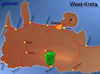
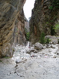
The gorge is in southwest Crete in the prefecture of Chania. It was created by a small river running between the White Mountains (Lefká Óri) and Mt. Volakias. There are a number of other gorges in the White Mountains. While some say that the gorge is 18 km long, this distance refers to the distance between the settlement of Omalos on the northern side of the plateau and the village of Agia Roumeli
Agia Roumeli
Agia Roumeli is a small village in southwest Crete, Greece and is popular with tourists. Located a few kilometres above the town is the southern entrance to the Samaria Gorge. For most walkers, this is the exit, as the usual route through the gorge is to descend from the north...
. In fact, the gorge is 16 km long, starting at an altitude of 1,250 m at the northern entrance, and ending at the shores of the Libyan Sea in Agia Roumeli
Agia Roumeli
Agia Roumeli is a small village in southwest Crete, Greece and is popular with tourists. Located a few kilometres above the town is the southern entrance to the Samaria Gorge. For most walkers, this is the exit, as the usual route through the gorge is to descend from the north...
. The walk through Samaria National Park is 13 km long, but you have to walk another three km to Agia Roumeli
Agia Roumeli
Agia Roumeli is a small village in southwest Crete, Greece and is popular with tourists. Located a few kilometres above the town is the southern entrance to the Samaria Gorge. For most walkers, this is the exit, as the usual route through the gorge is to descend from the north...
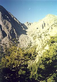
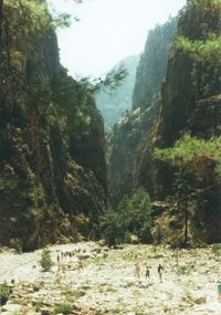
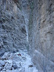
from the park exit, making the hike 16 km. The most famous part of the gorge is the stretch known as the Iron Gates, where the sides of the gorge close in to a width of only four meters and soar up to a height of 1,100m (3,610feet).
The gorge became a national park in 1962, particularly as a refuge for the rare kri-kri
Kri-kri
The Kri-kri , sometimes called the Cretan goat, Agrimi, or Cretan Ibex, was considered a subspecies of Wild Goat, but has been recently found to be a feral variety of the domestic goat...
(Cretan goat
Goat
The domestic goat is a subspecies of goat domesticated from the wild goat of southwest Asia and Eastern Europe. The goat is a member of the Bovidae family and is closely related to the sheep as both are in the goat-antelope subfamily Caprinae. There are over three hundred distinct breeds of...
), which is largely restricted to the park and an island just off the shore of Agia Marina
Agia Marina
Agia Marina may refer to several locations:In Greece:* Agia Marina, Crete, near Chania, Crete* Agia Marina, Elis, in Elis Prefecture* Agia Marina, Kavala, in Kavala Prefecture* Agia Marina, Leros, in Leros, Dodecanese PrefectureIn Cyprus:...
. There are several other endemic species
Endemic (ecology)
Endemism is the ecological state of being unique to a defined geographic location, such as an island, nation or other defined zone, or habitat type; organisms that are indigenous to a place are not endemic to it if they are also found elsewhere. For example, all species of lemur are endemic to the...
in the gorge and surrounding area, as well as many other species of flowers and birds.
The village of Samariá lies just inside the gorge. It was finally abandoned by the last remaining inhabitants in 1962 to make way for the park. The village and the gorge take their names from the village's ancient church, Óssia María ["the Bones of Mary"].
A "must" for visitors to Crete is to complete the walk down the gorge from the Omalos plateau to Agia Roumeli on the Libyan Sea, at which point tourists sail to the nearby village of Hora Sfakion
Hora Sfakion
Image:Chora Sfakion 1941 evacuation monument.jpg|thumb|right|200px|Monument commemorating the evacuation during WW2 of British and ANZAC forces from Hora Sfakion in May 1941. Click on the left plaque for a closer viewrect 198 536 320 1082 rect 0 0 900 1200...
and catch a coach back to Chania. The walk takes 4–7 hours and can be strenuous, especially at the height of summer.
Local tourist operators provide organized tours to the Gorge. These include bus transportation from your hotel to the entrance (near Omalos village), and the bus will be waiting for you to disembark the ferry in Sfakia (Hora Sfakeon) to take you back. If you are on your own, you can make a one-day round trip from Chania (see below) or from Sougia or Paleochora. Note that the morning buses from Sougia and Paleochora do not operate on Sunday. The ferries leave Agia Roumeli to Chora Sfakeon (East-bound) and to Sougia/Paleochora (West-bound) at 18:00.
There also exists a "lazy way" - from Agia Roumeli to the Iron Gates (more or less an hour of non-challenging terrain) and back.
Information provided by the Chania Forest Protection Service
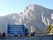
- Visits to the National park are allowed from May 1 to October 15.
- Park visiting hours are 07:00 to 15:00 daily. From 15:00 to sunset, visitors are allowed to walk a distance of only two km within the park, either from Xyloskalo or from Agia Roumeli.
- Within the park it is strictly prohibited to camp, stay overnight, light fires, or swim in the streams of the gorge.
How to visit from Chania
- There are daily buses starting from ChaniaChaniaChaniá , , also transliterated Chania, Hania, and Xania, older form Chanea and Venetian Canea, Ottoman Turkish خانيه Hanya) is the second largest city of Crete and the capital of the Chania peripheral unit...
to the head of the gorge, called Xyloskalo. The buses, marked "OMALOS", depart Chania Central Bus Station at 08:30; the fare for a round trip is €14.40. - The morning buses take one hour. The gorge is 12.8 km (8 mi) long, but there is another distance of 3.2 km (2 mi) to walk after leaving the gorge to reach Agia Roumeli; you need five to six hours to walk the 16 km. Be aware that it's always going downhill and thus is strenuous to the knees.
- The entrance fee is €5 (no less money for children or students, 2011).
- There is plenty of drinking water all along the gorge. Sneakers or hiking boots are recommended.
- At the end of the gorge plus 3.2 km (2 mi) is Agia Roumeli, a village with restaurants and accommodation, and boats to Chora Sfakion or Sougia. To return the same day, take the 17:00 boat (fare: €9.00, 2011) to Chora Sfakion.
- From Chora Sfakion, buses return to Chania, departing at 18:30; the bus always waits for the boat to arrive.
- Tickets for the two buses can be reserved at the ticket office at the Chania bus station. The ticket for the boat can be purchased in Agia Roumeli only .
- There are daily guided tours operated by various travel agencies, whose cost is usually around €20 (2011) and which includes fare for buses and the tour guide. The price does not include boat tickets (€9.00)and entrance fees (€5.00), which is usually collected separately on the bus.
Other gorges in Crete
- Agia Eirini GorgeAgia Eirini GorgeAgia Eirini Gorge is located in the south-west of the island of Crete, Greece, in Lefka Ori. The gorge starts near the village of Agia Eirini and it ends near the village of Sougia, on the south coast. It is long and deep, in a forested area with steep mountain cliffs, and is easy to walk...
- Gorge of the Dead
- Ha GorgeHa GorgeHa Gorge is a gorge on the eastern part of the island ofCrete in Greece. It is located in the west slope of Thrypti mountain and exits eastof Vasiliki village in the plain of Ierapetra. The gorge is about 1.5km...
- Imbros GorgeImbros GorgeImbros Gorge is a 11 km long canyon located near Hora Sfakion in southern Crete, the Mediterranean island. It runs parallel to Samariá Gorge, its narrowest part has 1.60 m and it ends at the village of Kommitádes...
- Kotsifos GorgeKotsifos GorgeThe Kotsifos Gorge is a gorge on the southern side of the western part of the island of Crete. It is situated west of the mountain of Kouroupa, north of the town of Plakias, and on the road between Sellia and Angouseliana. It is noted for the high number of Cretan endemic plant species that grow...
- Kourtaliotiko GorgeKourtaliotiko GorgeThe Kourtaliotiko Gorge , also known as the Asomatos Gorge, is a gorge on the southern side of the western part of the island of Crete.It is situated where the Kourtaliotiko River flows southwards between the mountains of Kouroupa and Xiron....
- Richtis GorgeRichtis GorgeRichtis Gorge refers to a gorge in Crete, Greece . It is a state protected park near Exo Mouliana, Sitia, eastern Crete that starts at the traditional village Exo Mouliana, which is located on the national road between Agios Nikolaos and Sitia and ends at the secluded Richtis beach, just east of...
- Sarakina GorgeSarakina GorgeThe Sarakina Gorge is a canyon in the southeastern part of Crete, Greece. It is located about 15 km west of Ierapetra and a few kilometres upcountry of Myrtos, near the small village of Mithi.- Facts :Its length is about 1.5 km and the width between 3 and 10 meters, only at a few point...