
Salt Island, Anglesey
Encyclopedia
Salt Island is an island joined to Holy Island
, itself an island joined to Anglesey
in North Wales
. It is a natural provider of shelter for the towns Old Harbour from the Irish Sea
and is also where the ferries to Dublin sail from.
. By the early 18th century the sea salt was often mixed with rock salt (often smuggled onto the island) to increase the quality of the factory's product. The factory ceased production in 1775.
Another building no longer standing on the island was the Stanley Sailor's Hospital. This hospital
was set up in 1871 by a local philanthropist and initially only treated sailors although it quickly became a general hospital. It was taken over by the National Health Service
in 1948 and closed its doors in 1987.
Lighthouse.
There is a matching tower in Howth
, Ireland
, also designed by Rennie, for the other terminal of the Irish packet steamer. The lighthouse is of national significance as one of John Rennie's surviving works. He was one of the most eminent engineers of the world’s first Industrial Revolution
. Of particular importance, in a Welsh context, is the early date of the lighthouse lantern, which was originally lit by gas. Before the conversion to electricity a gas works was located on the island to power the lighthouse, the piers and even part of Holyhead itself. The works were constructed at a cost of £130,000, an astronomical sum at the time. The tower survives intact and has beautifully curving gallery railings, similar to those at Bardsey Island
Lighthouse. It is no longer in use, although it is used as a navigation reference for sailors.
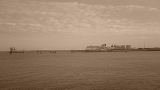
 The main pier
on the island, the Admiralty Pier, was opened in 1821. At around 300 metres long it extends east into the sea and has been used to handle ferry traffic since it was opened. Due to its important historical links between Great Britain and Ireland the pier has twice had royal visitors, once on 7 August 1821 when King George IV arrived from Ireland and once in 1898 when Queen Victoria set sail for her last voyage to Ireland.
An inner arm, pairing the existing 5,100 feet long breakwater (built between 1848-1876) was planned from Salt Island. The isolated broad gauge tramway railway from the Holyhead Mountain
quarry used to build the former had a branch to Salt Island, via Newry Beach, to facilitate this. Although started with an intention to be 2,100 feet long, the inner arm was never developed beyond a rubble spit at the northern tip of the island. Stone blocks that supported this tramway are still to be found along the upper seafront of Newry Beach. No trace remains of the, presumably, wooden viaduct across the Borth Sach inlet which provided access to the island. During the nineteen nineties the remains of rails were still to be found amongst the large boulders deposited as the foundations for the inner arm.
In more recent times, starting in February 2001, the island was expanded into the sea by the process of land reclamation
. In total 11 acres (44,515.5 m²) was gained at a cost of £10 million. An average of 7,000 tonnes of rock and mud was extracted per day during the process.
 Salt Island is part of the port
of Holyhead
and almost the whole extent of the island is used as a passenger, car and freight terminal and berths for ferries to and from Ireland
. Both Irish Ferries and Stena Line
sail from Salt Island to Dublin port and to Dún Laoghaire
. The Holyhead lifeboat
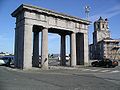
station is on the island. The Admiralty Arch, the end of the A5 which links London
to Holyhead is located very close to the southern tip of the island. This was opened in 1826 when the last section of the road the Menai Suspension Bridge
was completed. There is a beach
on the island which was open to the public but was shut in 2003 due to the increasing terror threat and still hasn't reopened. Access to the island as a whole is strictly monitored and is virtually impossible for pedestrian
s to enter.
Holy Island, Anglesey
Holy Island Cybi') is an island on the western side of the larger Isle of Anglesey, North Wales, from which it is separated by a narrow, winding channel. It is called "Holy" because of the high concentration of standing stones, burial chambers and other religious sites on the small island. The...
, itself an island joined to Anglesey
Anglesey
Anglesey , also known by its Welsh name Ynys Môn , is an island and, as Isle of Anglesey, a county off the north west coast of Wales...
in North Wales
North Wales
North Wales is the northernmost unofficial region of Wales. It is bordered to the south by the counties of Ceredigion and Powys in Mid Wales and to the east by the counties of Shropshire in the West Midlands and Cheshire in North West England...
. It is a natural provider of shelter for the towns Old Harbour from the Irish Sea
Irish Sea
The Irish Sea separates the islands of Ireland and Great Britain. It is connected to the Celtic Sea in the south by St George's Channel, and to the Atlantic Ocean in the north by the North Channel. Anglesey is the largest island within the Irish Sea, followed by the Isle of Man...
and is also where the ferries to Dublin sail from.
History
The island gained its name by a factory located on it which processed sea water in order to extract sea saltSea salt
Sea salt, salt obtained by the evaporation of seawater, is used in cooking and cosmetics. It is historically called bay salt or solar salt...
. By the early 18th century the sea salt was often mixed with rock salt (often smuggled onto the island) to increase the quality of the factory's product. The factory ceased production in 1775.
Another building no longer standing on the island was the Stanley Sailor's Hospital. This hospital
Hospital
A hospital is a health care institution providing patient treatment by specialized staff and equipment. Hospitals often, but not always, provide for inpatient care or longer-term patient stays....
was set up in 1871 by a local philanthropist and initially only treated sailors although it quickly became a general hospital. It was taken over by the National Health Service
National Health Service
The National Health Service is the shared name of three of the four publicly funded healthcare systems in the United Kingdom. They provide a comprehensive range of health services, the vast majority of which are free at the point of use to residents of the United Kingdom...
in 1948 and closed its doors in 1987.
Lighthouse
There have been three lighthouses located on the island. The current lighthouse, the Holyhead Mail Pier Light, is a conical white house which was built by the civil engineer John Rennie in 1821. It is probably the second oldest lighthouse in Wales, after Point of AyrPoint of Ayr
Point of Ayr is the northernmost point of mainland Wales. It is situated immediately to the north of Talacre in Flintshire, at the mouth of the Dee estuary. It is to the southwest of the Liverpool Bay area of the Irish Sea...
Lighthouse.
There is a matching tower in Howth
Howth
Howth is an area in Fingal County near Dublin city in Ireland. Originally just a small fishing village, Howth with its surrounding rural district is now a busy suburb of Dublin, with a mix of dense residential development and wild hillside, all on the peninsula of Howth Head. The only...
, Ireland
Ireland
Ireland is an island to the northwest of continental Europe. It is the third-largest island in Europe and the twentieth-largest island on Earth...
, also designed by Rennie, for the other terminal of the Irish packet steamer. The lighthouse is of national significance as one of John Rennie's surviving works. He was one of the most eminent engineers of the world’s first Industrial Revolution
Industrial Revolution
The Industrial Revolution was a period from the 18th to the 19th century where major changes in agriculture, manufacturing, mining, transportation, and technology had a profound effect on the social, economic and cultural conditions of the times...
. Of particular importance, in a Welsh context, is the early date of the lighthouse lantern, which was originally lit by gas. Before the conversion to electricity a gas works was located on the island to power the lighthouse, the piers and even part of Holyhead itself. The works were constructed at a cost of £130,000, an astronomical sum at the time. The tower survives intact and has beautifully curving gallery railings, similar to those at Bardsey Island
Bardsey Island
Bardsey Island , the legendary "Island of 20,000 saints", lies off the Llŷn Peninsula in the Welsh county of Gwynedd. The Welsh name means "The Island in the Currents", although its English name refers to the "Island of the Bards", or possibly the island of the Viking chieftan, "Barda". It is ...
Lighthouse. It is no longer in use, although it is used as a navigation reference for sailors.
Pier
Pier
A pier is a raised structure, including bridge and building supports and walkways, over water, typically supported by widely spread piles or pillars...
on the island, the Admiralty Pier, was opened in 1821. At around 300 metres long it extends east into the sea and has been used to handle ferry traffic since it was opened. Due to its important historical links between Great Britain and Ireland the pier has twice had royal visitors, once on 7 August 1821 when King George IV arrived from Ireland and once in 1898 when Queen Victoria set sail for her last voyage to Ireland.
An inner arm, pairing the existing 5,100 feet long breakwater (built between 1848-1876) was planned from Salt Island. The isolated broad gauge tramway railway from the Holyhead Mountain
Holyhead Mountain
Holyhead Mountain is the highest hill on Holy Island, Anglesey, and the highest in the county of Anglesey, north Wales. It lies about three kilometres west of the town of Holyhead, and slopes steeply down to the Irish Sea on two sides...
quarry used to build the former had a branch to Salt Island, via Newry Beach, to facilitate this. Although started with an intention to be 2,100 feet long, the inner arm was never developed beyond a rubble spit at the northern tip of the island. Stone blocks that supported this tramway are still to be found along the upper seafront of Newry Beach. No trace remains of the, presumably, wooden viaduct across the Borth Sach inlet which provided access to the island. During the nineteen nineties the remains of rails were still to be found amongst the large boulders deposited as the foundations for the inner arm.
In more recent times, starting in February 2001, the island was expanded into the sea by the process of land reclamation
Land reclamation
Land reclamation, usually known as reclamation, is the process to create new land from sea or riverbeds. The land reclaimed is known as reclamation ground or landfill.- Habitation :...
. In total 11 acres (44,515.5 m²) was gained at a cost of £10 million. An average of 7,000 tonnes of rock and mud was extracted per day during the process.
Transport and access
Port
A port is a location on a coast or shore containing one or more harbors where ships can dock and transfer people or cargo to or from land....
of Holyhead
Holyhead
Holyhead is the largest town in the county of Anglesey in the North Wales. It is also a major port adjacent to the Irish Sea serving Ireland....
and almost the whole extent of the island is used as a passenger, car and freight terminal and berths for ferries to and from Ireland
Ireland
Ireland is an island to the northwest of continental Europe. It is the third-largest island in Europe and the twentieth-largest island on Earth...
. Both Irish Ferries and Stena Line
Stena Line
Stena Line is one of the world's largest ferry operators, with ferry services serving Scotland, Sweden, Northern Ireland, Denmark, Norway, England, Wales, Ireland, Germany, the Netherlands and Poland. Stena Line is a major unit of Stena AB, itself a part of the Stena Sphere, a grouping of Stena AB,...
sail from Salt Island to Dublin port and to Dún Laoghaire
Dún Laoghaire
Dún Laoghaire or Dún Laoire , sometimes anglicised as "Dunleary" , is a suburban seaside town in County Dublin, Ireland, about twelve kilometres south of Dublin city centre. It is the county town of Dun Laoghaire-Rathdown County and a major port of entry from Great Britain...
. The Holyhead lifeboat
Lifeboat (rescue)
A rescue lifeboat is a boat rescue craft which is used to attend a vessel in distress, or its survivors, to rescue crewmen and passengers. It can be hand pulled, sail powered or powered by an engine...
station is on the island. The Admiralty Arch, the end of the A5 which links London
London
London is the capital city of :England and the :United Kingdom, the largest metropolitan area in the United Kingdom, and the largest urban zone in the European Union by most measures. Located on the River Thames, London has been a major settlement for two millennia, its history going back to its...
to Holyhead is located very close to the southern tip of the island. This was opened in 1826 when the last section of the road the Menai Suspension Bridge
Menai Suspension Bridge
The Menai Suspension Bridge is a suspension bridge between the island of Anglesey and the mainland of Wales. Designed by Thomas Telford and completed in 1826, it was the first modern suspension bridge in the world.-Construction:...
was completed. There is a beach
Beach
A beach is a geological landform along the shoreline of an ocean, sea, lake or river. It usually consists of loose particles which are often composed of rock, such as sand, gravel, shingle, pebbles or cobblestones...
on the island which was open to the public but was shut in 2003 due to the increasing terror threat and still hasn't reopened. Access to the island as a whole is strictly monitored and is virtually impossible for pedestrian
Pedestrian
A pedestrian is a person traveling on foot, whether walking or running. In some communities, those traveling using roller skates or skateboards are also considered to be pedestrians. In modern times, the term mostly refers to someone walking on a road or footpath, but this was not the case...
s to enter.