
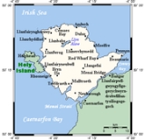
Holy Island, Anglesey
Encyclopedia
Holy Island is an island
(15.22 sq mi (39.4 km²)) on the western side of the larger Isle of Anglesey, North Wales
, from which it is separated by a narrow, winding channel. It is called "Holy" because of the high concentration of standing stones, burial chambers and other religious sites on the small island. The alternative and historic name of the island is Holyhead Island. According to the 2001 Census, the population is 13,579.
pirates invaded Anglesey following the withdrawal of Rome from Britannia
. Cunedda
first began warfare against the Irish but ultimately Cadwallon Lawhir defeated the Irish on Holy Island.
s on Anglesey including mudflat
s, dunes, marsh
es, and beach
es. The western side of the island is taken up mainly by Holyhead Mountain
, an area of maritime heather moor, which is the highest peak in the county at 722 feet (220m).
, and the original bridge of the A5 post road. The second is Four Mile Bridge
which carries a 'B' road and is much smaller.
The main settlement is the port of Holyhead
, from which passenger ferries travel to Dún Laoghaire
and Dublin, Ireland
, and freight ferries also travel to Dublin.
Around 30 miles (48.3 km) of the 125 miles (201.2 km) Anglesey Coastal Path
is on Holy Island.
, and South Stack
, with its famous lighthouse. Before—and even after—the construction of lighthouses, the cliffs and jagged rocks of the island were a great danger to sailors.
Island
An island or isle is any piece of sub-continental land that is surrounded by water. Very small islands such as emergent land features on atolls can be called islets, cays or keys. An island in a river or lake may be called an eyot , or holm...
(15.22 sq mi (39.4 km²)) on the western side of the larger Isle of Anglesey, North Wales
North Wales
North Wales is the northernmost unofficial region of Wales. It is bordered to the south by the counties of Ceredigion and Powys in Mid Wales and to the east by the counties of Shropshire in the West Midlands and Cheshire in North West England...
, from which it is separated by a narrow, winding channel. It is called "Holy" because of the high concentration of standing stones, burial chambers and other religious sites on the small island. The alternative and historic name of the island is Holyhead Island. According to the 2001 Census, the population is 13,579.
History
IrishIreland
Ireland is an island to the northwest of continental Europe. It is the third-largest island in Europe and the twentieth-largest island on Earth...
pirates invaded Anglesey following the withdrawal of Rome from Britannia
Britannia
Britannia is an ancient term for Great Britain, and also a female personification of the island. The name is Latin, and derives from the Greek form Prettanike or Brettaniai, which originally designated a collection of islands with individual names, including Albion or Great Britain. However, by the...
. Cunedda
Cunedda
Cunedda ap Edern , was an important early Welsh leader, and the progenitor of the royal dynasty of Gwynedd.-Background and life:The name Cunedda derives from the Brythonic word , meaning good hound. His genealogy is traced back to Padarn Beisrudd, which literally translates as Paternus of the...
first began warfare against the Irish but ultimately Cadwallon Lawhir defeated the Irish on Holy Island.
Natural features
There are a variety of natural habitatHabitat
* Habitat , a place where a species lives and grows*Human habitat, a place where humans live, work or play** Space habitat, a space station intended as a permanent settlement...
s on Anglesey including mudflat
Mudflat
Mudflats or mud flats, also known as tidal flats, are coastal wetlands that form when mud is deposited by tides or rivers. They are found in sheltered areas such as bays, bayous, lagoons, and estuaries. Mudflats may be viewed geologically as exposed layers of bay mud, resulting from deposition of...
s, dunes, marsh
Marsh
In geography, a marsh, or morass, is a type of wetland that is subject to frequent or continuous flood. Typically the water is shallow and features grasses, rushes, reeds, typhas, sedges, other herbaceous plants, and moss....
es, and beach
Beach
A beach is a geological landform along the shoreline of an ocean, sea, lake or river. It usually consists of loose particles which are often composed of rock, such as sand, gravel, shingle, pebbles or cobblestones...
es. The western side of the island is taken up mainly by Holyhead Mountain
Holyhead Mountain
Holyhead Mountain is the highest hill on Holy Island, Anglesey, and the highest in the county of Anglesey, north Wales. It lies about three kilometres west of the town of Holyhead, and slopes steeply down to the Irish Sea on two sides...
, an area of maritime heather moor, which is the highest peak in the county at 722 feet (220m).
Transport
Holy Island is connected to Anglesey by two road links. The first is made up of causeways carrying the A5/A55 road and the main railway line to Chester and LondonLondon
London is the capital city of :England and the :United Kingdom, the largest metropolitan area in the United Kingdom, and the largest urban zone in the European Union by most measures. Located on the River Thames, London has been a major settlement for two millennia, its history going back to its...
, and the original bridge of the A5 post road. The second is Four Mile Bridge
Four Mile Bridge
Four Mile Bridge is the name given to a bridge and the village surrounding it in Anglesey, Wales. They are so named because they are located around four miles southeast of Holyhead, the largest town on the island....
which carries a 'B' road and is much smaller.
The main settlement is the port of Holyhead
Holyhead
Holyhead is the largest town in the county of Anglesey in the North Wales. It is also a major port adjacent to the Irish Sea serving Ireland....
, from which passenger ferries travel to Dún Laoghaire
Dún Laoghaire
Dún Laoghaire or Dún Laoire , sometimes anglicised as "Dunleary" , is a suburban seaside town in County Dublin, Ireland, about twelve kilometres south of Dublin city centre. It is the county town of Dun Laoghaire-Rathdown County and a major port of entry from Great Britain...
and Dublin, Ireland
Republic of Ireland
Ireland , described as the Republic of Ireland , is a sovereign state in Europe occupying approximately five-sixths of the island of the same name. Its capital is Dublin. Ireland, which had a population of 4.58 million in 2011, is a constitutional republic governed as a parliamentary democracy,...
, and freight ferries also travel to Dublin.
Around 30 miles (48.3 km) of the 125 miles (201.2 km) Anglesey Coastal Path
Anglesey Coastal Path
The Anglesey Coastal Path is a long-distance footpath around the island of Anglesey in North Wales....
is on Holy Island.
Shipwrecks
Peripheral islands and stacks include North StackNorth Stack
North Stack is a small island situated just off Holy Island on the north-west coast of Anglesey.North Stack can also refer to the headland opposite the island...
, and South Stack
South Stack
South Stack is an island situated just off Holy Island on the North West coast of Anglesey. It is famous as the location of one of Wales' most spectacular lighthouses.-South Stack Lighthouse:...
, with its famous lighthouse. Before—and even after—the construction of lighthouses, the cliffs and jagged rocks of the island were a great danger to sailors.