
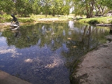
Salado Springs
Encyclopedia
Salado Springs is the name of five groups of springs
at the town of Salado
in Bell County
, Texas
, in the United States
. The springs are located 48 miles (77 km) north of Austin
or 135 miles (217 km) south of Dallas
.
The springs, which are not saline (salado is Spanish
for "salty"), were likely named for Salado Creek
.
zone, and they reach the surface through artesian
pressure by way of faults in the Cretaceous
Edwards limestone. The main recharge area for the springs is probably several miles to the southwest in Williamson County
, where several faults
intersect with Salado Creek.
The larger of the springs include Robertson Springs, Big Boiling Spring, Elm, Benedict, and Anderson springs. The latter three are located downstream (east) of the others. During the 1980s, the combined flow from all of the springs averaged approximately 122 gallons (460 liters) per second.
The Balcones Fault Zone at Barton Springs is a demarcation line for certain ecological systems and species distributions. For example, the California Fan Palm, Washingtonia filifera
is distributed strictly west of Barton Springs or the Balcones Fault.
peoples for thousands of years before that. Spanish
explorer Juan Antonio Bustillo y Ceballos probably visited the springs in 1732 as he traveled westward through the region. The area was settled by Archibald Willingham in 1851 and subsequently became a well-known stage stop, as well as a stop on the Chisholm Trail
. A dam
was built in 1863 to power a mill
, but this flooded some of the springs. A court order finally caused the dam to be lowered in 1878.
Spring (hydrosphere)
A spring—also known as a rising or resurgence—is a component of the hydrosphere. Specifically, it is any natural situation where water flows to the surface of the earth from underground...
at the town of Salado
Salado, Texas
Salado is a village in Bell County, Texas, United States. Salado was first incorporated in 1867 for the sole purpose of building a bridge across the Salado Creek...
in Bell County
Bell County, Texas
Bell County is a county located in the U.S. state of Texas. Bell County was founded in 1850. It is part of the Killeen–Temple–Fort Hood Metropolitan Statistical Area. In 2000, the county's population was 237,974; in 2010 the U.S. Census Bureau reported that its population had reached...
, Texas
Texas
Texas is the second largest U.S. state by both area and population, and the largest state by area in the contiguous United States.The name, based on the Caddo word "Tejas" meaning "friends" or "allies", was applied by the Spanish to the Caddo themselves and to the region of their settlement in...
, in the United States
United States
The United States of America is a federal constitutional republic comprising fifty states and a federal district...
. The springs are located 48 miles (77 km) north of Austin
Austin, Texas
Austin is the capital city of the U.S. state of :Texas and the seat of Travis County. Located in Central Texas on the eastern edge of the American Southwest, it is the fourth-largest city in Texas and the 14th most populous city in the United States. It was the third-fastest-growing large city in...
or 135 miles (217 km) south of Dallas
Dallas, Texas
Dallas is the third-largest city in Texas and the ninth-largest in the United States. The Dallas-Fort Worth Metroplex is the largest metropolitan area in the South and fourth-largest metropolitan area in the United States...
.
The springs, which are not saline (salado is Spanish
Spanish language
Spanish , also known as Castilian , is a Romance language in the Ibero-Romance group that evolved from several languages and dialects in central-northern Iberia around the 9th century and gradually spread with the expansion of the Kingdom of Castile into central and southern Iberia during the...
for "salty"), were likely named for Salado Creek
Salado Creek
Salado Creek is a waterway in San Antonio that runs from Northern Bexar County for about to the San Antonio River near Buena Vista.-Watershed:...
.
Geography and natural history
The Salado Springs are located in the Balcones FaultBalcones Fault
The Balcones Fault Zone is a tensional structural system in Texas that runs approximately from the southwest part of the state near Del Rio to the north central region near Waco along Interstate 35. The Balcones Fault zone is made up of many smaller features, including normal faults, grabens, and...
zone, and they reach the surface through artesian
Artesian aquifer
An artesian aquifer is a confined aquifer containing groundwater under positive pressure. This causes the water level in a well to rise to a point where hydrostatic equilibrium has been reached. This type of well is called an artesian well...
pressure by way of faults in the Cretaceous
Cretaceous
The Cretaceous , derived from the Latin "creta" , usually abbreviated K for its German translation Kreide , is a geologic period and system from circa to million years ago. In the geologic timescale, the Cretaceous follows the Jurassic period and is followed by the Paleogene period of the...
Edwards limestone. The main recharge area for the springs is probably several miles to the southwest in Williamson County
Williamson County, Texas
Williamson County is a county located on both the Edwards Plateau to the west, consisting of rocky terrain and hills, and Blackland Prairies in the east consising of rich, fertile farming land, The two areas are roughly bisected by Interstate 35...
, where several faults
Geologic fault
In geology, a fault is a planar fracture or discontinuity in a volume of rock, across which there has been significant displacement along the fractures as a result of earth movement. Large faults within the Earth's crust result from the action of tectonic forces...
intersect with Salado Creek.
The larger of the springs include Robertson Springs, Big Boiling Spring, Elm, Benedict, and Anderson springs. The latter three are located downstream (east) of the others. During the 1980s, the combined flow from all of the springs averaged approximately 122 gallons (460 liters) per second.
The Balcones Fault Zone at Barton Springs is a demarcation line for certain ecological systems and species distributions. For example, the California Fan Palm, Washingtonia filifera
Washingtonia filifera
Washingtonia filifera , with the common names California Fan Palm , Desert Fan Palm, Cotton palm, and Arizona Fan Palm. It is a palm native to southwestern North America between an elevation range of , at seeps, desert bajadas, and springs where underground water is continuously available...
is distributed strictly west of Barton Springs or the Balcones Fault.
History
The Salado Springs area was occupied for many years by the Tawakoni Indians, and by Paleo IndianPaleo Indians
Paleo-Indians or Paleoamericans is a classification term given to the first peoples who entered, and subsequently inhabited, the American continent during the final glacial episodes of the late Pleistocene period...
peoples for thousands of years before that. Spanish
Spain
Spain , officially the Kingdom of Spain languages]] under the European Charter for Regional or Minority Languages. In each of these, Spain's official name is as follows:;;;;;;), is a country and member state of the European Union located in southwestern Europe on the Iberian Peninsula...
explorer Juan Antonio Bustillo y Ceballos probably visited the springs in 1732 as he traveled westward through the region. The area was settled by Archibald Willingham in 1851 and subsequently became a well-known stage stop, as well as a stop on the Chisholm Trail
Chisholm Trail
The Chisholm Trail was a trail used in the late 19th century to drive cattle overland from ranches in Texas to Kansas railheads. The portion of the trail marked by Jesse Chisholm went from his southern trading post near the Red River, to his northern trading post near Kansas City, Kansas...
. A dam
Dam
A dam is a barrier that impounds water or underground streams. Dams generally serve the primary purpose of retaining water, while other structures such as floodgates or levees are used to manage or prevent water flow into specific land regions. Hydropower and pumped-storage hydroelectricity are...
was built in 1863 to power a mill
Mill (grinding)
A grinding mill is a unit operation designed to break a solid material into smaller pieces. There are many different types of grinding mills and many types of materials processed in them. Historically mills were powered by hand , working animal , wind or water...
, but this flooded some of the springs. A court order finally caused the dam to be lowered in 1878.