
Saintes
Encyclopedia
Saintes is a French commune
located in Poitou-Charentes
, in the southwestern Charente-Maritime
department of which it is a sub-prefecture. Its inhabitants are called Saintaises and Saintais.
Saintes is the second city in Charente-Maritime, with inhabitants in 2008; its metropolitan area, the second urban area in the department, counts inhabitants.
Primarily built on the left bank of the river Charente, Saintes became the capital of the province of Saintonge
under the Ancien Régime; it briefly became the prefecture
of the department (then called Charente-Inférieure) during the territorial reorganization of 1790, until La Rochelle took its place in 1810. Even though it was but a subprefectureThe prefecture of Charente-Maritime
is La Rochelle
and the subprefectures are, alphabetically: Jonzac
, Rochefort, Saint-Jean-d'Angély
and Saintes., Saintes was allowed to remain the center of the judiciary life in the department. In the last third of the XIXth century, Saintes was chosen as the seat of the VIIIth arrondissement of the Chemins de Fer de l'État, which enabled an era of economic and demographic growth.
Saintes remains today an important hub of transportation ; it is also the economic heart of the center of the department. Its industry counts but a few companies (electronics industry, rail repair, construction of hoists), but the city is an important commercial (with the seat of Coop Atlantique) and tertiary center (administrative functions of state, criminal court and judicial activities, banks, schools, hospital).
Because of its noteworthy gallo-roman, medieval and classical heritage, Saintes is a popular touristic destination, member of the French Towns and Lands of Art and History
since 1990. It has several museums, a theater, cinemas, and organizes numerous festivals. An european center of musical research and practice is located in the Abbaye aux Dames.
, in the center-eastern part of the department. The city is located 60 km southeast of La Rochelle, 33 kilometers northeast of Royan and about 100 km north of Bordeaux (to which it is linked by the A10 autoroute
).
: the Santonian
(approximately 84 Ma ago, after the Coniacian
and Campanian
). Saintes is indeed built on rocks dating from this period, limestone that consist of particular flint
nodules of quartz
geodes and nodules of iron
. Ancient stone quarries located in Capitol Hill or Bellevue, partially filled or converted to permit fungiculture
, make remember that they were long used for the construction of various buildings, though they can be cracked by frost.
Nearer to the river, the Createceous pleateau gives way to more or less recent alluvial grasslands composed of bri, a type of clay.
The uplifting of Alps
and Pyrenees
began during the Maastrichtian
, 65 Ma ago, and continued for a part of the Paleogene
.
A little westwards lies the neighborhood of Saint-Eutrope, that has developed over the centuries around a rocky elevation limited by two small valleys perpendicular to the river. Dominated by the basilica Saint-Eutrope, it also contains the remains of a clunian priory and several hillside houses. Little alleys lead to the vallon des Arènes below, where is situated the Roman amphiteatre, in a park named "Parc des Arènes".
The cours Reverseaux and the cours des Apôtres de la liberté separate the neighborhood of Saint-Eutrope from the faubourg Berthonnière, bordered by the hill of Saint-Eutrope at the west and by the hill of the Capitole at the north. Once located out of the city walls, it included some hostelries and inns for pilgrims. The streets of the faubourg converge toward the place Saint-Louis, the place de l'Aubarrée and the place Blair, dominated by a column of Liberty erected during the Revolution. The square Goulebenéze stands between the place Blair and the river.
The neighborhoods of les Boiffiers and Bellevue are separated from the rest of the city by the avenue de Saintonge ; they consist mainly in low-rent housing (HLM) and suburban housing standing on a plateau limited by the Charente. Bellevue counts inhabitants on 17 ha ; it is listed as a zone urbaine sensible
(ZUS).
In a triangle formed by the cours du maréchal Leclerc, the cours Genet and the rocade ouest (bypass), the neighborhood of Recouvrance contains a lycée, the former seminary, the Yvon Chevalier stadium and a shopping mall. The water tower of Recouvrance is decorated by frescoes by contemporary artist Michel Genty.
The northern part of the agglomeration is formed by the Saint-Vivien neighborhood, an old faubourg occupied since the Antiquity and where are situated the thermes de Saint-Saloine, ancient roman baths.
. Knowing a relative development during the Middle Ages, it sees the establishment of a funeral basilica dedicated to the bishop Palladius (later replaced by the église Saint-Pallais, which gives its name to the neighborhood), then a Benedictine abbey of women amongst the largest in the region, the Abbaye aux Dames de Saintes. The presence of this monumental heritage led to the integration of part of the neighborhood in a conservation area. It is during the XIXth century that the neighborhood begins to develop. The antic bridge is destroyed and replaced in 1879 by the pont Bernard-Palissy, a few meters upstream ; the avenue Gambetta
and the place Bassompierre are formed ; the train station, the Gare de Saintes
, the prison, the Haras national de Saintes, the parc Pierre-Mendès France, the Jardin public Fernand Chapsal and the protected area of the prairie de la Palu were subsequently created.
and several secondary roads, national and departmental, that converge towards the rocade (partly a 2x2) that bypasses the city on its western and southern sides.
The A10 autoroute (France)
, operated locally by Autoroutes du Sud de la France, passes through the commune in its western part, in a north-south axis. It can be accessed by the interchange 35. By the A10, Saintes is 125 km from Bordeaux
, 140 km from Poitiers
, 470 km from Paris
.
The A837 autoroute
is a spur road of the A10 that links Saintes to Rochefort
, the third city in the department.
Saintes is also located on the way of the Route Centre-Europe Atlantique, an expressway that links it to Limoges
and Lyon
in the east. The section Saintes-Saujon
(2x2 ways) has been opened to traffic in 2008 ; the towns are now 25 minutes apart by car. An extension towards Royan
will be made.
The rocade is formed in its western part by the national road 137, that meets two important ways, the departmental road 728 (that links Saintes to the Island of Oleron
by Marennes
) and the departmental road 150 that intersects with the rocade near the locality of Diconche. In its southern part, the rocade integrates the national road 141, that runs towards Cognac
, Angoulême
and Limoges
. The departmental road 150, at the end of the east part, runs towards Niort
by Saint-Hilaire-de-Villefranche
et Saint-Jean-d'Angély
. The town center of Saintes is bypassed by the avenue de Saintonge or departmental road 24, that crosses the Charente with the bridge de Saintonge, opened in 1969.
(train station) is located at the focal point of five railways that link the agglomeration to Nantes
(by La Rochelle
), Bordeaux, Angoulême, Niort and Royan ; the trains are mainly part of the regional rail
network TER Poitou-Charentes
and the network Corail Intercités
In 1894, the station was the starting point of a 3 km long network of tramways that was stopped in 1934. In 1894 was also founded a secondary railway 42 km long linking Saintes to Mortagne-sur-Gironde
, by Gémozac
, then a somewhat important economic center ; however, this railway was dismantled in 1947.
The importance of this railway network is explained by the designation of Saintes as the seat of the Compagnie des chemins de fer des Charentes in 1867, then as the regional seat of the VIIIth arrondissement of the Chemins de fer de l'État from 1911 to 1971. The SNCF is still a major employer in the city, and new depots and workshops have been opened in 2009 and 2010.
From 1793 to 2007

The main museums include:
– Nivelles
, Belgium – Timbuktu
, Mali – Vladimir, Russia – Salisbury
, England, United Kingdom – Cuevas del Almanzora
, Spain – Xanten
, Germany
Communes of France
The commune is the lowest level of administrative division in the French Republic. French communes are roughly equivalent to incorporated municipalities or villages in the United States or Gemeinden in Germany...
located in Poitou-Charentes
Poitou-Charentes
Poitou-Charentes is an administrative region in central western France comprising four departments: Charente, Charente-Maritime, Deux-Sèvres and Vienne. The regional capital is Poitiers.-Politics:The regional council is composed of 56 members...
, in the southwestern Charente-Maritime
Charente-Maritime
Charente-Maritime is a department on the west coast of France named after the Charente River.- History :Previously a part of Saintonge, Charente-Inférieure was one of the 83 original departments created during the French Revolution on 4 March 1790...
department of which it is a sub-prefecture. Its inhabitants are called Saintaises and Saintais.
Saintes is the second city in Charente-Maritime, with inhabitants in 2008; its metropolitan area, the second urban area in the department, counts inhabitants.
Primarily built on the left bank of the river Charente, Saintes became the capital of the province of Saintonge
Saintonge
Saintonge is a small region on the Atlantic coast of France within the département Charente-Maritime, west and south of Charente in the administrative region of Poitou-Charentes....
under the Ancien Régime; it briefly became the prefecture
Prefecture
A prefecture is an administrative jurisdiction or subdivision in any of various countries and within some international church structures, and in antiquity a Roman district governed by an appointed prefect.-Antiquity:...
of the department (then called Charente-Inférieure) during the territorial reorganization of 1790, until La Rochelle took its place in 1810. Even though it was but a subprefectureThe prefecture of Charente-Maritime
Charente-Maritime
Charente-Maritime is a department on the west coast of France named after the Charente River.- History :Previously a part of Saintonge, Charente-Inférieure was one of the 83 original departments created during the French Revolution on 4 March 1790...
is La Rochelle
La Rochelle
La Rochelle is a city in western France and a seaport on the Bay of Biscay, a part of the Atlantic Ocean. It is the capital of the Charente-Maritime department.The city is connected to the Île de Ré by a bridge completed on 19 May 1988...
and the subprefectures are, alphabetically: Jonzac
Jonzac
Jonzac is a commune of the Charente-Maritime department in southwestern France.-Population:-References:*...
, Rochefort, Saint-Jean-d'Angély
Saint-Jean-d'Angély
Saint-Jean-d'Angély is a commune in the Charente-Maritime department in southwestern France.The commune has its historical origins in the Abbey of Saint-Jean-d'Angély.-Royal abbey:...
and Saintes., Saintes was allowed to remain the center of the judiciary life in the department. In the last third of the XIXth century, Saintes was chosen as the seat of the VIIIth arrondissement of the Chemins de Fer de l'État, which enabled an era of economic and demographic growth.
Saintes remains today an important hub of transportation ; it is also the economic heart of the center of the department. Its industry counts but a few companies (electronics industry, rail repair, construction of hoists), but the city is an important commercial (with the seat of Coop Atlantique) and tertiary center (administrative functions of state, criminal court and judicial activities, banks, schools, hospital).
Because of its noteworthy gallo-roman, medieval and classical heritage, Saintes is a popular touristic destination, member of the French Towns and Lands of Art and History
French towns and lands of Art and History
Since 1985, the French Ministry of Culture and Communication has pursued a policy of preserving and promoting France's heritage. Historic towns and districts have been designated Villes et Pays d'Art et d'Histoire ....
since 1990. It has several museums, a theater, cinemas, and organizes numerous festivals. An european center of musical research and practice is located in the Abbaye aux Dames.
Location
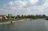
Saintes is located on the banks of the Charente RiverCharente River
The Charente is a 381 km long river in southwestern France.Its source is in the Haute-Vienne département at Chéronnac, a small village near Rochechouart. It flows through the departments of Haute-Vienne, Charente, Vienne and Charente-Maritime...
, in the center-eastern part of the department. The city is located 60 km southeast of La Rochelle, 33 kilometers northeast of Royan and about 100 km north of Bordeaux (to which it is linked by the A10 autoroute
A10 autoroute (France)
The A10, also called L'Aquitaine, is an Autoroute in France, running for 549 km from the A6 south of Paris to the A630 at Bordeaux. It generally parallels the N10 Route Nationale, but deviates significantly from the older N10 between Paris and Tours and between Poitiers and Bordeaux...
).
Geology
A chronostratigraphic stage has been named after Saintes, or more exactly after its ancient inhabitants, the SantonesSantones
The Santones or Santoni were a tribe of ancient Gaul located in the modern region of Saintonge and around the city of Saintes, city to which they gave their name. The Romans occupied the territory of the Santones from the 1st century BC....
: the Santonian
Santonian
The Santonian is an age in the geologic timescale or a chronostratigraphic stage. It is a subdivision of the Late Cretaceous epoch or Upper Cretaceous series. It spans the time between 85.8 ± 0.7 mya and 83.5 ± 0.7 mya...
(approximately 84 Ma ago, after the Coniacian
Coniacian
The Coniacian is an age or stage in the geologic timescale. It is a subdivision of the Late Cretaceous epoch or Upper Cretaceous series and spans the time between 89.3 ± 1 Ma and 85.8 ± 0.7 Ma...
and Campanian
Campanian
The Campanian is, in the ICS' geologic timescale, the fifth of six ages of the Late Cretaceous epoch . The Campanian spans the time from 83.5 ± 0.7 Ma to 70.6 ± 0.6 Ma ...
). Saintes is indeed built on rocks dating from this period, limestone that consist of particular flint
Flint
Flint is a hard, sedimentary cryptocrystalline form of the mineral quartz, categorized as a variety of chert. It occurs chiefly as nodules and masses in sedimentary rocks, such as chalks and limestones. Inside the nodule, flint is usually dark grey, black, green, white, or brown in colour, and...
nodules of quartz
Quartz
Quartz is the second-most-abundant mineral in the Earth's continental crust, after feldspar. It is made up of a continuous framework of SiO4 silicon–oxygen tetrahedra, with each oxygen being shared between two tetrahedra, giving an overall formula SiO2. There are many different varieties of quartz,...
geodes and nodules of iron
Iron
Iron is a chemical element with the symbol Fe and atomic number 26. It is a metal in the first transition series. It is the most common element forming the planet Earth as a whole, forming much of Earth's outer and inner core. It is the fourth most common element in the Earth's crust...
. Ancient stone quarries located in Capitol Hill or Bellevue, partially filled or converted to permit fungiculture
Fungiculture
Fungiculture is the process of producing food, medicine, and other products by the cultivation of mushrooms and other fungi.The word is also commonly used to refer to the practice of cultivating fungi by leafcutter ants, termites, ambrosia beetles, and marsh periwinkles.- Introduction :Mushrooms...
, make remember that they were long used for the construction of various buildings, though they can be cracked by frost.
Nearer to the river, the Createceous pleateau gives way to more or less recent alluvial grasslands composed of bri, a type of clay.
The uplifting of Alps
Alps
The Alps is one of the great mountain range systems of Europe, stretching from Austria and Slovenia in the east through Italy, Switzerland, Liechtenstein and Germany to France in the west....
and Pyrenees
Pyrenees
The Pyrenees is a range of mountains in southwest Europe that forms a natural border between France and Spain...
began during the Maastrichtian
Maastrichtian
The Maastrichtian is, in the ICS' geologic timescale, the latest age or upper stage of the Late Cretaceous epoch or Upper Cretaceous series, the Cretaceous period or system, and of the Mesozoic era or erathem. It spanned from 70.6 ± 0.6 Ma to 65.5 ± 0.3 Ma...
, 65 Ma ago, and continued for a part of the Paleogene
Paleogene
The Paleogene is a geologic period and system that began 65.5 ± 0.3 and ended 23.03 ± 0.05 million years ago and comprises the first part of the Cenozoic Era...
.
City shape
The town is divided in several administrative areas : Les Boiffiers, Les Tourneurs, L'Ormeau de Pied, Recouvrance, La Fenêtre, Saint-Rémy, Saint-Vivien, Saint-Eutrope, Saint-Pierre, Saint-Pallais, Saint-Sébastien de Bouard, La Récluse, Le Maine-Saint-Sorlin and Bellevue.Left bank (Rive gauche)
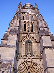
The neighborhood of Saint-Pierre lies between the hill of the Capitole and the Charente. It possesses a significant number of historic monuments, which explains its integration in a conservation area that lies over more of 65 ha. Built around the cathedral Saint-Pierre, the place du marché and the place du Synode, it is crossed by pedestrian alleys around which can be found numerous medieval, renaissance and classic buildings.A little westwards lies the neighborhood of Saint-Eutrope, that has developed over the centuries around a rocky elevation limited by two small valleys perpendicular to the river. Dominated by the basilica Saint-Eutrope, it also contains the remains of a clunian priory and several hillside houses. Little alleys lead to the vallon des Arènes below, where is situated the Roman amphiteatre, in a park named "Parc des Arènes".
The cours Reverseaux and the cours des Apôtres de la liberté separate the neighborhood of Saint-Eutrope from the faubourg Berthonnière, bordered by the hill of Saint-Eutrope at the west and by the hill of the Capitole at the north. Once located out of the city walls, it included some hostelries and inns for pilgrims. The streets of the faubourg converge toward the place Saint-Louis, the place de l'Aubarrée and the place Blair, dominated by a column of Liberty erected during the Revolution. The square Goulebenéze stands between the place Blair and the river.
The neighborhoods of les Boiffiers and Bellevue are separated from the rest of the city by the avenue de Saintonge ; they consist mainly in low-rent housing (HLM) and suburban housing standing on a plateau limited by the Charente. Bellevue counts inhabitants on 17 ha ; it is listed as a zone urbaine sensible
Sensitive urban zone
A sensitive urban zone is an urban area in France defined by the authorities to be a high-priority target for city policy, taking into consideration local circumstances related to the problems of its residents...
(ZUS).
In a triangle formed by the cours du maréchal Leclerc, the cours Genet and the rocade ouest (bypass), the neighborhood of Recouvrance contains a lycée, the former seminary, the Yvon Chevalier stadium and a shopping mall. The water tower of Recouvrance is decorated by frescoes by contemporary artist Michel Genty.
The northern part of the agglomeration is formed by the Saint-Vivien neighborhood, an old faubourg occupied since the Antiquity and where are situated the thermes de Saint-Saloine, ancient roman baths.
Right bank (Rive droite)
The neighborhood of Saint-Pallais was probably urbanized in Antiquity. Structured around the main access way of the roman city, it was then linked to the town center by a bridge with a monumental entrance, the Arch of GermanicusArch of Germanicus
The Arch of Germanicus is an ancient Roman triumphal arch in Saintes, Charente-Maritime in France. It was built in 18 or 19 by a rich citizen of the town , C. Julius Rufus, and dedicated to the emperor Tiberius and his adoptive sons Drusus Caesar and Germanicus...
. Knowing a relative development during the Middle Ages, it sees the establishment of a funeral basilica dedicated to the bishop Palladius (later replaced by the église Saint-Pallais, which gives its name to the neighborhood), then a Benedictine abbey of women amongst the largest in the region, the Abbaye aux Dames de Saintes. The presence of this monumental heritage led to the integration of part of the neighborhood in a conservation area. It is during the XIXth century that the neighborhood begins to develop. The antic bridge is destroyed and replaced in 1879 by the pont Bernard-Palissy, a few meters upstream ; the avenue Gambetta
Gambetta
Gambetta may refer to:People*Léon Gambetta , French statesman.*Schubert Gambetta , Uruguayan footballer*Diego Gambetta, Italian sociologistOther uses*Gambetta...
and the place Bassompierre are formed ; the train station, the Gare de Saintes
Gare de Saintes
Gare de Saintes is a railway station serving the town Saintes, Charente-Maritime department, western France.-Services:The following services currently call at Saintes:*intercity services Quimper - Nantes - La Rochelle - Bordeaux - Toulouse...
, the prison, the Haras national de Saintes, the parc Pierre-Mendès France, the Jardin public Fernand Chapsal and the protected area of the prairie de la Palu were subsequently created.
Adjacent communes
Roads
Saintes is a transportation hub of some importance, connected by two motorwaysAutoroute
Autoroute may refer to:* Controlled-access highway, particularly in French speaking countries* Routing , when routes to wires in a design are automatically assigned...
and several secondary roads, national and departmental, that converge towards the rocade (partly a 2x2) that bypasses the city on its western and southern sides.
The A10 autoroute (France)
A10 autoroute (France)
The A10, also called L'Aquitaine, is an Autoroute in France, running for 549 km from the A6 south of Paris to the A630 at Bordeaux. It generally parallels the N10 Route Nationale, but deviates significantly from the older N10 between Paris and Tours and between Poitiers and Bordeaux...
, operated locally by Autoroutes du Sud de la France, passes through the commune in its western part, in a north-south axis. It can be accessed by the interchange 35. By the A10, Saintes is 125 km from Bordeaux
Bordeaux
Bordeaux is a port city on the Garonne River in the Gironde department in southwestern France.The Bordeaux-Arcachon-Libourne metropolitan area, has a population of 1,010,000 and constitutes the sixth-largest urban area in France. It is the capital of the Aquitaine region, as well as the prefecture...
, 140 km from Poitiers
Poitiers
Poitiers is a city on the Clain river in west central France. It is a commune and the capital of the Vienne department and of the Poitou-Charentes region. The centre is picturesque and its streets are interesting for predominant remains of historical architecture, especially from the Romanesque...
, 470 km from Paris
Paris
Paris is the capital and largest city in France, situated on the river Seine, in northern France, at the heart of the Île-de-France region...
.
The A837 autoroute
A837 autoroute
The A837 autoroute is a motorway in western France it is also known as the Autoroute des Oiseaux.Approximately 38 km long it connects Saintes to Rochefort.-Junctions:*Exchange A10-A837 Junction with A10 to Bordeaux to Paris....
is a spur road of the A10 that links Saintes to Rochefort
Rochefort, Charente-Maritime
Rochefort is a commune in southwestern France, a port on the Charente estuary. It is a sub-prefecture of the Charente-Maritime department.-History:...
, the third city in the department.
Saintes is also located on the way of the Route Centre-Europe Atlantique, an expressway that links it to Limoges
Limoges
Limoges |Limousin]] dialect of Occitan) is a city and commune, the capital of the Haute-Vienne department and the administrative capital of the Limousin région in west-central France....
and Lyon
Lyon
Lyon , is a city in east-central France in the Rhône-Alpes region, situated between Paris and Marseille. Lyon is located at from Paris, from Marseille, from Geneva, from Turin, and from Barcelona. The residents of the city are called Lyonnais....
in the east. The section Saintes-Saujon
Saujon
Saujon is a commune in the Charente-Maritime department in southwestern France.-Population:-References:*...
(2x2 ways) has been opened to traffic in 2008 ; the towns are now 25 minutes apart by car. An extension towards Royan
Royan
Royan is a commune in the Charente-Maritime department, along the Atlantic Ocean, in southwestern France.A seaside resort, Royan is in the heart of an urban area estimated at 38,638 inhabitants, which makes it the fourth-largest conurbation in the department, after La Rochelle, Rochefort and Saintes...
will be made.
The rocade is formed in its western part by the national road 137, that meets two important ways, the departmental road 728 (that links Saintes to the Island of Oleron
Oléron
Île d'Oléron is an island off the Atlantic coast of France , on the southern side of the Pertuis d'Antioche strait....
by Marennes
Marennes, Charente-Maritime
Marennes is a commune in the Charente-Maritime department in southwestern France.For a long time it was one of the most prosperous cities of the Saintonge due to its location in the middle of the salt-water marshes at a time where salt was a valuable commodity.Marennes is a center for oyster...
) and the departmental road 150 that intersects with the rocade near the locality of Diconche. In its southern part, the rocade integrates the national road 141, that runs towards Cognac
Cognac
Cognac is a commune in the Charente department in southwestern France. It is a sub-prefecture of the department.-Geography:Cognac is situated on the river Charente between the towns of Angoulême and Saintes. The majority of the town has been built on the river's left bank, with the smaller right...
, Angoulême
Angoulême
-Main sights:In place of its ancient fortifications, Angoulême is encircled by boulevards above the old city walls, known as the Remparts, from which fine views may be obtained in all directions. Within the town the streets are often narrow. Apart from the cathedral and the hôtel de ville, the...
and Limoges
Limoges
Limoges |Limousin]] dialect of Occitan) is a city and commune, the capital of the Haute-Vienne department and the administrative capital of the Limousin région in west-central France....
. The departmental road 150, at the end of the east part, runs towards Niort
Niort
Niort is a commune in the Deux-Sèvres department in western France.The Latin name of the city was Novioritum.The population of Niort is 60,486 and more than 137,000 people live in the urban area....
by Saint-Hilaire-de-Villefranche
Saint-Hilaire-de-Villefranche
Saint-Hilaire-de-Villefranche is a commune in the Charente-Maritime department in southwestern France.-Population:-References:*...
et Saint-Jean-d'Angély
Saint-Jean-d'Angély
Saint-Jean-d'Angély is a commune in the Charente-Maritime department in southwestern France.The commune has its historical origins in the Abbey of Saint-Jean-d'Angély.-Royal abbey:...
. The town center of Saintes is bypassed by the avenue de Saintonge or departmental road 24, that crosses the Charente with the bridge de Saintonge, opened in 1969.
Train
The Gare de SaintesGare de Saintes
Gare de Saintes is a railway station serving the town Saintes, Charente-Maritime department, western France.-Services:The following services currently call at Saintes:*intercity services Quimper - Nantes - La Rochelle - Bordeaux - Toulouse...
(train station) is located at the focal point of five railways that link the agglomeration to Nantes
Nantes
Nantes is a city in western France, located on the Loire River, from the Atlantic coast. The city is the 6th largest in France, while its metropolitan area ranks 8th with over 800,000 inhabitants....
(by La Rochelle
La Rochelle
La Rochelle is a city in western France and a seaport on the Bay of Biscay, a part of the Atlantic Ocean. It is the capital of the Charente-Maritime department.The city is connected to the Île de Ré by a bridge completed on 19 May 1988...
), Bordeaux, Angoulême, Niort and Royan ; the trains are mainly part of the regional rail
Regional rail
Commuter rail, also called suburban rail, is a passenger rail transport service that primarily operates between a city center, and the middle to outer suburbs beyond 15km and commuter towns or other locations that draw large numbers of commuters—people who travel on a daily basis...
network TER Poitou-Charentes
TER Poitou-Charentes
TER Poitou-Charentes the regional rail network serving the Poitou-Charentes région, France.- Rail :- Road :* Angoulême - Jonzac* Poitiers - Parthenay - Bressuire - Cholet - Nantes* Thouars - Loudun - Chinon...
and the network Corail Intercités
Intercités
Intercités is a brand name used by France’s national railway company, SNCF, to denote medium-distance passenger rail services in France. SNCF established the Intercités system in January 2006 as an upgrade of the former Corail network...
In 1894, the station was the starting point of a 3 km long network of tramways that was stopped in 1934. In 1894 was also founded a secondary railway 42 km long linking Saintes to Mortagne-sur-Gironde
Mortagne-sur-Gironde
Mortagne-sur-Gironde is a commune in the Charente-Maritime department in southwestern France.-Population:-References:*...
, by Gémozac
Gémozac
Gémozac is a commune in the Charente-Maritime department in southwestern France.-Population:-References:*...
, then a somewhat important economic center ; however, this railway was dismantled in 1947.
The importance of this railway network is explained by the designation of Saintes as the seat of the Compagnie des chemins de fer des Charentes in 1867, then as the regional seat of the VIIIth arrondissement of the Chemins de fer de l'État from 1911 to 1971. The SNCF is still a major employer in the city, and new depots and workshops have been opened in 2009 and 2010.
Population
Sights
- The Arch of GermanicusArch of GermanicusThe Arch of Germanicus is an ancient Roman triumphal arch in Saintes, Charente-Maritime in France. It was built in 18 or 19 by a rich citizen of the town , C. Julius Rufus, and dedicated to the emperor Tiberius and his adoptive sons Drusus Caesar and Germanicus...
, a triumphal archTriumphal archA triumphal arch is a monumental structure in the shape of an archway with one or more arched passageways, often designed to span a road. In its simplest form a triumphal arch consists of two massive piers connected by an arch, crowned with a flat entablature or attic on which a statue might be...
, was built at the entrance to a bridge, where the main Roman roadRoman roadThe Roman roads were a vital part of the development of the Roman state, from about 500 BC through the expansion during the Roman Republic and the Roman Empire. Roman roads enabled the Romans to move armies and trade goods and to communicate. The Roman road system spanned more than 400,000 km...
crossed the Charente River. The bridge was demolished in 1843 but the Arch was saved by Prosper MériméeProsper MériméeProsper Mérimée was a French dramatist, historian, archaeologist, and short story writer. He is perhaps best known for his novella Carmen, which became the basis of Bizet's opera Carmen.-Life:...
and rebuilt at its present location on the bank of the river. - Ruins of the Roman amphitheatreAmphitheatreAn amphitheatre is an open-air venue used for entertainment and performances.There are two similar, but distinct, types of structure for which the word "amphitheatre" is used: Ancient Roman amphitheatres were large central performance spaces surrounded by ascending seating, and were commonly used...
can be found on the left bank of the Charente, near the summit of the hill upon which the town was built. It is notable in that its tiers (the caveaCaveaIn Roman times the cavea were the subterranean cells in which wild animals were confined before the combats in the Roman arena or amphitheatre....
) are built against the hill and an embankment. - Some remnants of the thermaeThermaeIn ancient Rome, thermae and balnea were facilities for bathing...
of Saint-Saloine (First century) are also visible, in particular an aqueductAqueductAn aqueduct is a water supply or navigable channel constructed to convey water. In modern engineering, the term is used for any system of pipes, ditches, canals, tunnels, and other structures used for this purpose....
. - Fragments of the 3rd century rampart can be seen in the Place des Récollets. It was built with stones taken from the Roman buildings.
- The Abbaye-aux-DamesSainte-Marie-des-DamesThe Abbey of Sainte-Marie-des-Dames was the first Benedictine abbey for women in Saintes in Charente-Maritime in France. It was founded in 1047 by Geoffrey II, Count of Anjou...
, Madame de Montespan was educated here. - Saintes is also known for its other churches: the Basilique Saint-Eutrope and the Cathédrale Saint-Pierre. Saintes Cathedral: http://www.bernezac.com/Saintes_StPierre_clocher_02.jpg Basilique Saint-Eutrope: http://www.bernezac.com/Sainte_Eutrope_arenes_05.jpg,http://www.bernezac.com/Saintes_Eutrope_clocher_02.jpg
The main museums include:
- the Musée archéologique, which owns a Roman cart of the 1st century amongst a collection of sculptures and inscriptions.
- the Musée du Présidial, which has a manneristMannerismMannerism is a period of European art that emerged from the later years of the Italian High Renaissance around 1520. It lasted until about 1580 in Italy, when a more Baroque style began to replace it, but Northern Mannerism continued into the early 17th century throughout much of Europe...
architecture and a collection of regional ceramics and paintings of the 15th to 18th century. - the Musée de l'Échevinage, which exhibits porcelain of SèvresSèvresSèvres is a commune in the southwestern suburbs of Paris, France. It is located from the centre of Paris.The town is known for its porcelain manufacture, the Manufacture nationale de Sèvres, making the famous Sèvres porcelain, as well as being the location of the International Bureau of Weights...
and paintings of the 19th and 20th century
Education
Saintes is located in the académie de Poitiers.Public Kindergartens and elementary schools
Private elementary schools
|
Public collèges
Collège privé
Public lycées of general education
Private lycée of general education
|
Public professional lycées
Private professional lycée
Military chool
Superior education
|
- The collègesSecondary education in FranceIn France, secondary education is in two stages:* collèges cater for the first four years of secondary education from the ages of 11 to 14...
include: the Collège René Caillié, the Collège Agrippa d'Aubigné, the Collège Edgar Quinet and the Collège Jeanne d'Arc. - The lycéesSecondary education in FranceIn France, secondary education is in two stages:* collèges cater for the first four years of secondary education from the ages of 11 to 14...
include: the Lycée de Bellevue, the Lycée Bernard-Palissy, the Lycée Notre-Dame-de-Recouvrance and the Lycée Georges Desclaude (agricultural instruction). - Two American Universities conduct year round study abroad programs at the C.E.A.U., the University of Houston's Gerald D. Hines College of Architecture, and the University of Southern California.
Twin towns
Saintes is twinned with :– Nivelles
Nivelles
Nivelles is a Walloon city and municipality located in the Belgian province of Walloon Brabant. The Nivelles municipality includes the old communes of Baulers, Bornival, Thines, and Monstreux....
, Belgium – Timbuktu
Timbuktu
Timbuktu , formerly also spelled Timbuctoo, is a town in the West African nation of Mali situated north of the River Niger on the southern edge of the Sahara Desert. The town is the capital of the Timbuktu Region, one of the eight administrative regions of Mali...
, Mali – Vladimir, Russia – Salisbury
Salisbury
Salisbury is a cathedral city in Wiltshire, England and the only city in the county. It is the second largest settlement in the county...
, England, United Kingdom – Cuevas del Almanzora
Cuevas del Almanzora
-External links:* - Sistema de Información Multiterritorial de Andalucía - Diputación Provincial de Almería...
, Spain – Xanten
Xanten
Xanten is a historic town in the North Rhine-Westphalia state of Germany, located in the district of Wesel.Xanten is known for the Archaeological Park or archaeological open air museum , its medieval picturesque city centre with Xanten Cathedral and many museums, its large man-made lake for...
, Germany