

Sahuarita, Arizona
Encyclopedia
Sahuarita is a town in Pima County
, Arizona
, United States
. Sahuarita is located south of the Tohono O'odham
Nation and abuts the north end of Green Valley
, 15 miles (24 km) south of Tucson
. The population was 25,259 at the 2010 census.
people, which may be the ancestors of the modern day Tohono O'odham nation. The Hohokam were known for their highly innovative and extensive use of irrigation. The Hohokam were a very peaceful people, they had extensive trade routes extending to mesoamerica, and showed many cultural influences from their southern neighbors.
were possibly related to the Hohokam, and occupied the Southern portion of the Santa Cruz, with the Pima to their North and South. While Coronado passed just East of Sahuarita in 1521, it wasn't until Eusebio Kino
's 1691 journey along the Santa Cruz River that he met the leaders of the Sobaipuri people. Kino was a true champion of the indigenous Indians, opposing forced labor in mines by Spanish overseers. Kino would later go on to found the Mission San Xavier del Bac
in 1699, just north of Sahuarita. In 1775, Francisco Garcés would follow the same path, laying the groundwork for the founding of Tucson.
in 1821, the region came under Mexican control until they sold the land to the United States as part of the Gadsden Purchase
.
, Sahuarita would become a part of the Territory of New Mexico
, in the United States of America. In the same year, Andrew B. Gray would travel the region on behalf of the Texas Western Railroad, in order to run a preliminary survey of the region. Meanwhile, the native American peoples of the region were being pushed onto each other's land through American expansionism. In 1857, the Sobaipuri, who had acted as a buffer between the hostile Mexicans to the south and Apache to the north, finally collapsed under the pressure and vacated the area, generally moving westward to Papago territory. Sahuarita was part of the Confederate
Arizona Territory
between 1861 and 1862 before being captured by the Union
and incorporated into Arizona Territory
in 1863. In 1867, Fort Crittenden was created between Sonoita and Patagonia in order to support the establishment of American settlements in the Santa Cruz Valley. In 1874, the San Xavier reservation was created, presently called the Tohono O'odham Reservation, and native Americans were forcibly relocated to the reservation.
Finally, a 1925 map of "Auto Trails" (e.g. roadways) of Arizona and New Mexico lists "Continental" instead of Sahuarita. The roadway at the time was an "improved road", one step inferior to a "paved road", laying the route to what today is called the Old Nogales Highway.
s in the area. The ranch was used as a staging area between Tucson, Arivaca
, and Quijotoa. A small community developed in the area named Sahuarito, while the railroad laid tracks through the area (which remain to this day) and established a station and post office. Although originally surveyed by the Texas Western Railroad, the route would soon be run by the Southern Pacific Railroad
up until the late 20th century. Brown sold his ranch in 1886 which caused the region to stagnate for three decades.
During this time, the hub of Sahuarita commerce was at the intersection of Sahuarita Road and Nogales Highway, in the form of the One Stop Market and Sahuarita Bar and Grill. These 130-year-old buildings remain intact, but they are scheduled to be demolished for a road expansion: "While some have said the 1 Stop and the shuttered Sahuarita Bar on the north side of Sahuarita Road were long-time fixtures that might deserve historic recognition, the longest-serving council member, Charles Oldham, and the council member who lives closest, Marty Moreno, both said the convenience store should make way for badly needed road improvements. Oldham said, “It’s in the way”."
, Joseph Kennedy and J.P. Morgan founded the farm along the Santa Cruz River with hopes of growing guayule: plants that provide rubber. The project was abandoned after the end of World War I, and in 1922, was sold to Queen Wilhelmina of the Netherlands
. The Queen rented the land to cotton farmers, in what would be the primary crop for the following four decades. In 1948, R. Keith Walden relocated the Farmers Investment Co. (FICO) from California to Arizona, buying the Continental Farm lands from the Queen. In 1965, over fears of a fall in demand for cotton resulting from the advent of synthetic fibers, Walden switched his crop to pecans. Today, the FICO pecan orchard is the largest in the world, with over 6000 acres (24.3 km²) and 106,000 trees.
pilots for service in the war. Camp Continental, a labor camp for German prisoners of war was also located in Sahuarita. The location of the camp was around what is now Continental Ranch, West of the Nogales Highway and the Quail Crossing Boulevard intersection. It was established around November, 1944, as one of 21 "branch" POW camps established throughout the state. The population of 250 prisoners primarily worked in agriculture, tending to cotton and vegetable crops. More than one escape attempt was made by the Germans, all of which failed.
first used this 27046 acres (109.5 km²) range in April, 1942 for practice bombing runs. The Sahuarita Flight Strip was completed in 1943, with a 5540 feet (1,688.6 m) paved runway, and the bombing runs ceased shortly thereafter. The site included 12 buildings in addition to the airstrip, and four observational towers. In 1950, bomber crews operating out of Carswell AFB, TX, restarted bombing runs on the range, which would last until 1962, with the airway strip remaining in use as an emergency landing strip thereafter. The Federal government soon released the land to the State of Arizona in 1978, who in turn leased the land to a cattle rancher. Presently, the former airstrip has been converted into a roadway that leads to "Sahuarita Park", while the remaining land remains in use for cattle grazing. The U.S. Army Corps of Engineers is continuing its longstanding efforts of identifying remaining munitions, preventing environmental contamination, and protecting several endangered species in the area, including jaguars, spotted owls, among others. Several different types of expended ammunition rounds can be found throughout the range. most of which found are 10 to 20 mm anti-aircraft rounds. Shrapnel from the dropped ordnance
also litters the range, as well as dozens of crushed olive drab ammunition boxes. Shell casings and magazine clips can also be found, along with JATO
tanks and large cross targets, constructed of wood with orange reflectors for visibility from the air. The crosses were used as targets for the airmen in training. Many United States Tobacco Company
tins have been found, discarded by the several different aviators who occupied the area during its military days. The actual airstrip is now used as a road
leading to Sahuarita Park and the Edge Charter School. Both of which were built among the remains of the older air force buildings.
, built in 1963 during the height of the Cold War
, which is the only Titan Missile
site in the world accessible to the public. The actual Titan II missile, the most powerful nuclear missile on standby in the US, remains in the silo for visitors to see. The Sahuarita Airstrip continued to be used by the U.S. Airforce throughout most of the Cold War.
The Upper Santa Cruz Valley has several "major water users", all pumping water out of the same aquifer. None of these are owned by Pima County, the town of Sahuarita, nor Green Valley. The major water users are all private companies: ASARCO-Mission Mine, Phelps Dodge Sierrita Mine; Farmers Water Company; Sahuarita Water Company, Las Quintas Serenas Water Company, Quail Creek Water Company, Community Water Company of Green Valley, and the Green Valley Water District. The proliferation of water companies can be partially explained by the fact that the actual water in the aquifer is not owned by anyone, thus any amount of water can be pumped out, with costs limited only to drilling, pumping, distribution, etc.
, while in 2000, the population rose to 3,242. The U.S. Census Bureau estimated that it had a population of 13,027 in 2006.
In contrast to federal census data, in 2006 the Arizona Department of Economic Security assessed the town population at 18,035. The town has guessed that its 2008 population was around 24,000.
, the town has a total area of 15.2 square miles (39.4 km²), all of it land. Since the most recent census was taken in 2000, the town has annexed more land; its area is presently about 30 sq mi (80 km²). The Santa Cruz River (Arizona) runs through the desert
town, flowing north towards Tucson, mostly during the monsoons, or extended climatic wet periods. Late 19th century and early 20th century still contained beaver
in the river from Tucson, southwards. Madera Canyon
, located just southeast of the town is another important landmark, day trip site, and a birdwatching
point.
 The lake is a "managed lake", which means that natural ecological changes within the lake that do "not fit within the parameters set by man", are cause for remedial action to return to the goals of the management plan. Air compressors located at various points under the lake continually inject air through diffusers which aids the movement of water in a process called vertical mixing. This system of continual aeration enables the circulation of all water in the lake on a daily basis, and therefore creates an ecological balance and uniform appearance. The lake also contains fish and frogs, the former of which are regularly stocked by the Arizona State Department of Game and Fish, and is an attraction to ducks and various kinds of birds.
The lake consumes water to the extent that all the water in the lake must be replenished every year. Regarding water evaporation, lake documents state that according to the USDA Water Conservation Laboratory in Phoenix, the mean annual evaporation rate for Sahuarita is 69 inches (1,752.6 mm) per year. This results in a mean water loss of 57.5 acre.ft per year. Regarding water loss due to seepage, initial estimates indicated an annual loss of 10 acre.ft of water, or 17% of total capacity per year. The J. Harlan Glenn Engineers that provided this estimate indicated that this equates to an "extremely low seepage rate". On average, 65 gpm (gallons of water per minute) must be pumped into the lake to maintain its current level. A nearby well site that draws on the shared Upper Santa Cruz Valley aquifer is used to refill the lake. In 2006, 105.3 acre.ft of water was used for the entire Sahuarita lake park, which includes water for the 5 acres (20,234.3 m²) of grass and restroom facilities.
of 2000, there were 3,242 people, 1,155 households, and 927 families residing in the town. The population density
was 213.2 people per square mile (82.3/km²). There were 1,247 housing units at an average density of 82.0 per square mile (31.7/km²). The racial makeup of the town was 87.85% White
, 0.59% Black
or African American
, 1.08% Native American
, 0.99% Asian
, 7.40% from other races
, and 2.10% from two or more races. 24.18% of the population were Hispanic
or Latino
of any race.
There were 1,155 households out of which 33.4% had children under the age of 18 living with them, 70.6% were married couples
living together, 6.8% had a female householder with no husband present, and 19.7% were non-families. 15.3% of all households were made up of individuals and 5.1% had someone living alone who was 65 years of age or older. The average household size was 2.78 and the average family size was 3.09.
In the town the population was spread out with 25.6% under the age of 18, 7.2% from 18 to 24, 27.1% from 25 to 44, 24.7% from 45 to 64, and 15.4% who were 65 years of age or older. The median age was 38 years. For every 100 females there were 96.7 males. For every 100 females age 18 and over, there were 98.4 males.
The median income for a household in the town was $53,194, and the median income for a family was $55,338. Males had a median income of $42,258 versus $26,174 for females. The per capita income
for the town was $22,075. About 4.0% of families and 5.7% of the population were below the poverty line, including 6.6% of those under age 18 and 7.0% of those age 65 or over.
conducted an assessment survey of Sahuarita residents due to the town's 529% growth since the 2000 Census, because data from that census "on workforce and community characteristics is no longer applicable." The survey was mailed to 7,805 households and was weighted by area to ensure a representative sampling.
The survey reported that in educational attainment 19.7% of residents are high school graduates; 32.4% have an Associates Degree or some college; 26.9% have a Bachelor's degree, and 14.6% have a Master's degree, and 3.3% have a Doctoral degree. These statistics lead to the finding that "demonstrates significantly higher concentrations in associate’s, bachelor’s and graduate/professional degrees than the county as a whole, or the state."
For places of work, 57% of residents reported working in Tucson, with 16.6% working in Sahuarita, and 12.7% in Green Valley. It found that local workers specialized more than workers elsewhere in Pima County, being most concentrated in the following occupations:
Sahuarita is administered by the seven member town council, which includes a Mayor and Vice Mayor. The Mayor and Vice Mayor are not elected into those positions, but are instead chosen among elected council members. The town council oversees all issues pertaining to Sahuarita, including residential and commercial development and natural preservation.
The Town of Sahuarita is a general law town, and does not have a town charter. As a result, Sahuarita operates fully under Title 9: Cities and Towns, of the Arizona Revised Statutes.
Pima County, Arizona
-2010:Whereas according to the 2010 U.S. Census Bureau:*74.3% White*3.5% Black*3.3% Native American*2.6% Asian*0.2% Native Hawaiian or Pacific Islander*3.7% Two or more races*12.4% Other races*34.6% Hispanic or Latino -2000:...
, Arizona
Arizona
Arizona ; is a state located in the southwestern region of the United States. It is also part of the western United States and the mountain west. The capital and largest city is Phoenix...
, United States
United States
The United States of America is a federal constitutional republic comprising fifty states and a federal district...
. Sahuarita is located south of the Tohono O'odham
Tohono O'odham
The Tohono O'odham are a group of Native American people who reside primarily in the Sonoran Desert of the southeastern Arizona and northwest Mexico...
Nation and abuts the north end of Green Valley
Green Valley, Arizona
Green Valley is a census-designated place in Pima County, Arizona, United States. The population was 17,283 at the 2000 census.-Geography:Green Valley is located at ....
, 15 miles (24 km) south of Tucson
Tucson, Arizona
Tucson is a city in and the county seat of Pima County, Arizona, United States. The city is located 118 miles southeast of Phoenix and 60 miles north of the U.S.-Mexico border. The 2010 United States Census puts the city's population at 520,116 with a metropolitan area population at 1,020,200...
. The population was 25,259 at the 2010 census.
Hohokam (200 to 1450)
The first known human inhabitants of the Sahuarita region were the HohokamHohokam
Hohokam is one of the four major prehistoric archaeological Oasisamerica traditions of what is now the American Southwest. Many local residents put the accent on the first syllable . Variant spellings in current, official usage include Hobokam, Huhugam and Huhukam...
people, which may be the ancestors of the modern day Tohono O'odham nation. The Hohokam were known for their highly innovative and extensive use of irrigation. The Hohokam were a very peaceful people, they had extensive trade routes extending to mesoamerica, and showed many cultural influences from their southern neighbors.
Sobaipuri (1400 - 1900)
The SobaipuriSobaipuri
The Sobaipuri are one of many indigenous groups occupying Sonora at the time Europeans first entered the American Southwest. They were a Piman group who occupied southern Arizona and northern Sonora in the 15th-19th centuries...
were possibly related to the Hohokam, and occupied the Southern portion of the Santa Cruz, with the Pima to their North and South. While Coronado passed just East of Sahuarita in 1521, it wasn't until Eusebio Kino
Eusebio Kino
Eusebio Francisco Kino S.J. was an Italian Roman Catholic priest who became famous in what is now northwestern Mexico and the southwestern United States in the region then known as the Pimaria Alta...
's 1691 journey along the Santa Cruz River that he met the leaders of the Sobaipuri people. Kino was a true champion of the indigenous Indians, opposing forced labor in mines by Spanish overseers. Kino would later go on to found the Mission San Xavier del Bac
Mission San Xavier del Bac
Mission San Xavier del Bac is a historic Spanish Catholic mission located about 10 miles south of downtown Tucson, Arizona, on the Tohono O'odham San Xavier Indian Reservation...
in 1699, just north of Sahuarita. In 1775, Francisco Garcés would follow the same path, laying the groundwork for the founding of Tucson.
Spanish & Mexican control (1775 - 1853)
In 1775, after building a series of missions in the region, the Spanish established a fort in the Tucson region to control the native American settlements nearby. This just north of Sahuarita, which effectively placed the region under Spanish control. Eventually a town came to be and was named Tucson. After the Mexican War of IndependenceMexican War of Independence
The Mexican War of Independence was an armed conflict between the people of Mexico and the Spanish colonial authorities which started on 16 September 1810. The movement, which became known as the Mexican War of Independence, was led by Mexican-born Spaniards, Mestizos and Amerindians who sought...
in 1821, the region came under Mexican control until they sold the land to the United States as part of the Gadsden Purchase
Gadsden Purchase
The Gadsden Purchase is a region of present-day southern Arizona and southwestern New Mexico that was purchased by the United States in a treaty signed by James Gadsden, the American ambassador to Mexico at the time, on December 30, 1853. It was then ratified, with changes, by the U.S...
.
Incorporation into the U.S. (1854 -1874 )
In 1854, following the Gadsden PurchaseGadsden Purchase
The Gadsden Purchase is a region of present-day southern Arizona and southwestern New Mexico that was purchased by the United States in a treaty signed by James Gadsden, the American ambassador to Mexico at the time, on December 30, 1853. It was then ratified, with changes, by the U.S...
, Sahuarita would become a part of the Territory of New Mexico
New Mexico Territory
thumb|right|240px|Proposed boundaries for State of New Mexico, 1850The Territory of New Mexico was an organized incorporated territory of the United States that existed from September 9, 1850, until January 6, 1912, when the final extent of the territory was admitted to the Union as the State of...
, in the United States of America. In the same year, Andrew B. Gray would travel the region on behalf of the Texas Western Railroad, in order to run a preliminary survey of the region. Meanwhile, the native American peoples of the region were being pushed onto each other's land through American expansionism. In 1857, the Sobaipuri, who had acted as a buffer between the hostile Mexicans to the south and Apache to the north, finally collapsed under the pressure and vacated the area, generally moving westward to Papago territory. Sahuarita was part of the Confederate
Confederate States of America
The Confederate States of America was a government set up from 1861 to 1865 by 11 Southern slave states of the United States of America that had declared their secession from the U.S...
Arizona Territory
Arizona Territory (CSA)
The Territory of Arizona was a territory claimed by the Confederate States of America during the American Civil War, between 1861 and 1865. It consisted of the portion of the New Mexico Territory south of the 34th parallel north including parts of the modern states of New Mexico and Arizona. Its...
between 1861 and 1862 before being captured by the Union
Union Army
The Union Army was the land force that fought for the Union during the American Civil War. It was also known as the Federal Army, the U.S. Army, the Northern Army and the National Army...
and incorporated into Arizona Territory
Arizona Territory
The Territory of Arizona was an organized incorporated territory of the United States that existed from February 24, 1863 until February 14, 1912, when it was admitted to the Union as the 48th state....
in 1863. In 1867, Fort Crittenden was created between Sonoita and Patagonia in order to support the establishment of American settlements in the Santa Cruz Valley. In 1874, the San Xavier reservation was created, presently called the Tohono O'odham Reservation, and native Americans were forcibly relocated to the reservation.
Sahuarita on the map (1870 - 1925)
An 1870 map of Arizona shows an "Indian Village" just north of Sahuarita. The earliest known reference to the town can be found on a German map from 1875, which labels the town "Sahuarito". The first known US map to list the town came in 1879, by the US Department of Interior, calling the town "Saurita". The Saurita town name would continue to be found on successive maps of 1880 and 1890.Finally, a 1925 map of "Auto Trails" (e.g. roadways) of Arizona and New Mexico lists "Continental" instead of Sahuarita. The roadway at the time was an "improved road", one step inferior to a "paved road", laying the route to what today is called the Old Nogales Highway.
Sahuarita Ranch (1879 - 1886)
In 1879 Sahuarita Ranch was created by James Kilroy Brown. Brown choose the name Sahuarita due to the preponderance of saguaroSaguaro
The saguaro is a large, tree-sized cactus species in the monotypic genus Carnegiea. It is native to the Sonoran Desert in the U.S. state of Arizona, the Mexican state of Sonora, a small part of Baja California in the San Felipe Desert and an extremely small area of California, U.S...
s in the area. The ranch was used as a staging area between Tucson, Arivaca
Arivaca, Arizona
Arivaca is an unincorporated community in Pima County, Arizona, United States. It is located north of the Mexican border and northwest of the port of entry at Nogales. The European-American history of the area dates back at least to 1695, although the community was not founded until 1878....
, and Quijotoa. A small community developed in the area named Sahuarito, while the railroad laid tracks through the area (which remain to this day) and established a station and post office. Although originally surveyed by the Texas Western Railroad, the route would soon be run by the Southern Pacific Railroad
Southern Pacific Railroad
The Southern Pacific Transportation Company , earlier Southern Pacific Railroad and Southern Pacific Company, and usually simply called the Southern Pacific or Espee, was an American railroad....
up until the late 20th century. Brown sold his ranch in 1886 which caused the region to stagnate for three decades.
During this time, the hub of Sahuarita commerce was at the intersection of Sahuarita Road and Nogales Highway, in the form of the One Stop Market and Sahuarita Bar and Grill. These 130-year-old buildings remain intact, but they are scheduled to be demolished for a road expansion: "While some have said the 1 Stop and the shuttered Sahuarita Bar on the north side of Sahuarita Road were long-time fixtures that might deserve historic recognition, the longest-serving council member, Charles Oldham, and the council member who lives closest, Marty Moreno, both said the convenience store should make way for badly needed road improvements. Oldham said, “It’s in the way”."
Continental Farm (1915 - present)
The Continental Farm of Sahuarita plays a central role in town history. In 1915, worried about the possibility of a German blockade of rubber imports, Bernard BaruchBernard Baruch
Bernard Mannes Baruch was an American financier, stock-market speculator, statesman, and political consultant. After his success in business, he devoted his time toward advising U.S. Presidents Woodrow Wilson and Franklin D. Roosevelt on economic matters and became a philanthropist.-Early life...
, Joseph Kennedy and J.P. Morgan founded the farm along the Santa Cruz River with hopes of growing guayule: plants that provide rubber. The project was abandoned after the end of World War I, and in 1922, was sold to Queen Wilhelmina of the Netherlands
Wilhelmina of the Netherlands
Wilhelmina was Queen regnant of the Kingdom of the Netherlands from 1890 to 1948. She ruled the Netherlands for fifty-eight years, longer than any other Dutch monarch. Her reign saw World War I and World War II, the economic crisis of 1933, and the decline of the Netherlands as a major colonial...
. The Queen rented the land to cotton farmers, in what would be the primary crop for the following four decades. In 1948, R. Keith Walden relocated the Farmers Investment Co. (FICO) from California to Arizona, buying the Continental Farm lands from the Queen. In 1965, over fears of a fall in demand for cotton resulting from the advent of synthetic fibers, Walden switched his crop to pecans. Today, the FICO pecan orchard is the largest in the world, with over 6000 acres (24.3 km²) and 106,000 trees.
World War II (1941 - 1945)
During World War II, Sahuarita was home to the Sahuarita Airstrip which was used to train bomberBomber
A bomber is a military aircraft designed to attack ground and sea targets, by dropping bombs on them, or – in recent years – by launching cruise missiles at them.-Classifications of bombers:...
pilots for service in the war. Camp Continental, a labor camp for German prisoners of war was also located in Sahuarita. The location of the camp was around what is now Continental Ranch, West of the Nogales Highway and the Quail Crossing Boulevard intersection. It was established around November, 1944, as one of 21 "branch" POW camps established throughout the state. The population of 250 prisoners primarily worked in agriculture, tending to cotton and vegetable crops. More than one escape attempt was made by the Germans, all of which failed.
Sahuarita Bombing & Gunnery Range (1942 - 1978)
The Army Air Corp from Davis-Monthan Air Force BaseDavis-Monthan Air Force Base
Davis–Monthan Air Force Base is a United States Air Force base located within the city limits, and approximately south-southeast of downtown, Tucson, Arizona....
first used this 27046 acres (109.5 km²) range in April, 1942 for practice bombing runs. The Sahuarita Flight Strip was completed in 1943, with a 5540 feet (1,688.6 m) paved runway, and the bombing runs ceased shortly thereafter. The site included 12 buildings in addition to the airstrip, and four observational towers. In 1950, bomber crews operating out of Carswell AFB, TX, restarted bombing runs on the range, which would last until 1962, with the airway strip remaining in use as an emergency landing strip thereafter. The Federal government soon released the land to the State of Arizona in 1978, who in turn leased the land to a cattle rancher. Presently, the former airstrip has been converted into a roadway that leads to "Sahuarita Park", while the remaining land remains in use for cattle grazing. The U.S. Army Corps of Engineers is continuing its longstanding efforts of identifying remaining munitions, preventing environmental contamination, and protecting several endangered species in the area, including jaguars, spotted owls, among others. Several different types of expended ammunition rounds can be found throughout the range. most of which found are 10 to 20 mm anti-aircraft rounds. Shrapnel from the dropped ordnance
Aircraft ordnance
Aircraft ordnance or ordnance is weapons used by aircraft. The term is often used when describing the weight of air-to-ground weaponry that can be carried by an aircraft or the weight that has been dropped...
also litters the range, as well as dozens of crushed olive drab ammunition boxes. Shell casings and magazine clips can also be found, along with JATO
JATO
JATO is an acronym for jet-fuel assisted take off. It is a system for helping overloaded aircraft into the air by providing additional thrust in the form of small rockets....
tanks and large cross targets, constructed of wood with orange reflectors for visibility from the air. The crosses were used as targets for the airmen in training. Many United States Tobacco Company
U.S. Smokeless Tobacco Company
U.S. Smokeless Tobacco Company manufactures dipping tobacco and is a subsidiary of Altria.Its corporate headquarters are located in Stamford, Connecticut, and it maintains factories in Clarksville and Nashville, Tennessee, Franklin Park, Illinois, and Hopkinsville, Kentucky.Copenhagen and Skoal...
tins have been found, discarded by the several different aviators who occupied the area during its military days. The actual airstrip is now used as a road
Road
A road is a thoroughfare, route, or way on land between two places, which typically has been paved or otherwise improved to allow travel by some conveyance, including a horse, cart, or motor vehicle. Roads consist of one, or sometimes two, roadways each with one or more lanes and also any...
leading to Sahuarita Park and the Edge Charter School. Both of which were built among the remains of the older air force buildings.
Cold War
Sahuarita contains the Titan Missile MuseumTitan Missile Museum
The Titan Missile Museum, also known as Air Force Facility Missile Site 8 or as Titan II ICBM Site 571-7, is a former ICBM missile site located at 1580 West Duval Mine Road, Sahuarita, Arizona. It is located about 15 miles south of Tucson...
, built in 1963 during the height of the Cold War
Cold War
The Cold War was the continuing state from roughly 1946 to 1991 of political conflict, military tension, proxy wars, and economic competition between the Communist World—primarily the Soviet Union and its satellite states and allies—and the powers of the Western world, primarily the United States...
, which is the only Titan Missile
Titan (rocket family)
Titan was a family of U.S. expendable rockets used between 1959 and 2005. A total of 368 rockets of this family were launched, including all the Project Gemini manned flights of the mid-1960s...
site in the world accessible to the public. The actual Titan II missile, the most powerful nuclear missile on standby in the US, remains in the silo for visitors to see. The Sahuarita Airstrip continued to be used by the U.S. Airforce throughout most of the Cold War.
Water sustainability
In the desert southwest, water sustainability is a major concern. According to a 2007 report by Pima County, 76000 acre.ft of water was pumped from the aquifer in the Upper Santa Cruz Valley in 2006 [in the report referred to as the Green Valley area, which includes Sahuarita], with 85 percent of that water being used for mining and agriculture. The remaining 15 percent was split between water used for golf courses and residential/commercial water use. The report explains that "The Green Valley area does not have a sustainable water supply given current groundwater pumping rates... the water table in Green Valley has been declining in past years, and is expected to decline even faster as water demands [continue to increase]...". The report concludes that "Water supplies will become critical within the next ten years."The Upper Santa Cruz Valley has several "major water users", all pumping water out of the same aquifer. None of these are owned by Pima County, the town of Sahuarita, nor Green Valley. The major water users are all private companies: ASARCO-Mission Mine, Phelps Dodge Sierrita Mine; Farmers Water Company; Sahuarita Water Company, Las Quintas Serenas Water Company, Quail Creek Water Company, Community Water Company of Green Valley, and the Green Valley Water District. The proliferation of water companies can be partially explained by the fact that the actual water in the aquifer is not owned by anyone, thus any amount of water can be pumped out, with costs limited only to drilling, pumping, distribution, etc.
Population
The population of the town was 1,629 in 1990United States Census, 1990
The Twenty-first United States Census, conducted by the Census Bureau, determined the resident population of the United States to be 248,709,873, an increase of 9.8 percent over the 226,545,805 persons enumerated during the 1980 Census....
, while in 2000, the population rose to 3,242. The U.S. Census Bureau estimated that it had a population of 13,027 in 2006.
In contrast to federal census data, in 2006 the Arizona Department of Economic Security assessed the town population at 18,035. The town has guessed that its 2008 population was around 24,000.
Geography
Sahuarita is located at 31°55′45"N 110°58′56"W (31.929245, -110.982241). According to the United States Census BureauUnited States Census Bureau
The United States Census Bureau is the government agency that is responsible for the United States Census. It also gathers other national demographic and economic data...
, the town has a total area of 15.2 square miles (39.4 km²), all of it land. Since the most recent census was taken in 2000, the town has annexed more land; its area is presently about 30 sq mi (80 km²). The Santa Cruz River (Arizona) runs through the desert
Desert
A desert is a landscape or region that receives an extremely low amount of precipitation, less than enough to support growth of most plants. Most deserts have an average annual precipitation of less than...
town, flowing north towards Tucson, mostly during the monsoons, or extended climatic wet periods. Late 19th century and early 20th century still contained beaver
Beaver
The beaver is a primarily nocturnal, large, semi-aquatic rodent. Castor includes two extant species, North American Beaver and Eurasian Beaver . Beavers are known for building dams, canals, and lodges . They are the second-largest rodent in the world...
in the river from Tucson, southwards. Madera Canyon
Madera Canyon
Madera Canyon is a canyon on the northwestern face of the Santa Rita Mountains, located 25 miles southeast of Tucson, Arizona. As part of the Coronado National Forest, the canyon has campsites, picnic areas, and miles of hiking trails. The canyon is used as a resting place for migrating birds, and...
, located just southeast of the town is another important landmark, day trip site, and a birdwatching
Birdwatching
Birdwatching or birding is the observation of birds as a recreational activity. It can be done with the naked eye, through a visual enhancement device like binoculars and telescopes, or by listening for bird sounds. Birding often involves a significant auditory component, as many bird species are...
point.
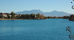
Sahuarita Lake
Sahuarita Lake is an artificial lake that was completed on June 22, 2001, by Rancho Sahuarita. The lake surface area is 435600 square feet (40,468.6 m²), with a 1 miles (1.6 km) long perimeter and maximum depth of 10 feet (3 m), holding approximately 70 acre.ft of water. This reflects a water amount equivalent to less than one tenth of one percent (< 0.1%) of the 76000 acre.ft of water used by all of Sahuarita and Green Valley in 2006.The lake consumes water to the extent that all the water in the lake must be replenished every year. Regarding water evaporation, lake documents state that according to the USDA Water Conservation Laboratory in Phoenix, the mean annual evaporation rate for Sahuarita is 69 inches (1,752.6 mm) per year. This results in a mean water loss of 57.5 acre.ft per year. Regarding water loss due to seepage, initial estimates indicated an annual loss of 10 acre.ft of water, or 17% of total capacity per year. The J. Harlan Glenn Engineers that provided this estimate indicated that this equates to an "extremely low seepage rate". On average, 65 gpm (gallons of water per minute) must be pumped into the lake to maintain its current level. A nearby well site that draws on the shared Upper Santa Cruz Valley aquifer is used to refill the lake. In 2006, 105.3 acre.ft of water was used for the entire Sahuarita lake park, which includes water for the 5 acres (20,234.3 m²) of grass and restroom facilities.
2000 census
As of the censusCensus
A census is the procedure of systematically acquiring and recording information about the members of a given population. It is a regularly occurring and official count of a particular population. The term is used mostly in connection with national population and housing censuses; other common...
of 2000, there were 3,242 people, 1,155 households, and 927 families residing in the town. The population density
Population density
Population density is a measurement of population per unit area or unit volume. It is frequently applied to living organisms, and particularly to humans...
was 213.2 people per square mile (82.3/km²). There were 1,247 housing units at an average density of 82.0 per square mile (31.7/km²). The racial makeup of the town was 87.85% White
Race (United States Census)
Race and ethnicity in the United States Census, as defined by the Federal Office of Management and Budget and the United States Census Bureau, are self-identification data items in which residents choose the race or races with which they most closely identify, and indicate whether or not they are...
, 0.59% Black
Race (United States Census)
Race and ethnicity in the United States Census, as defined by the Federal Office of Management and Budget and the United States Census Bureau, are self-identification data items in which residents choose the race or races with which they most closely identify, and indicate whether or not they are...
or African American
Race (United States Census)
Race and ethnicity in the United States Census, as defined by the Federal Office of Management and Budget and the United States Census Bureau, are self-identification data items in which residents choose the race or races with which they most closely identify, and indicate whether or not they are...
, 1.08% Native American
Race (United States Census)
Race and ethnicity in the United States Census, as defined by the Federal Office of Management and Budget and the United States Census Bureau, are self-identification data items in which residents choose the race or races with which they most closely identify, and indicate whether or not they are...
, 0.99% Asian
Race (United States Census)
Race and ethnicity in the United States Census, as defined by the Federal Office of Management and Budget and the United States Census Bureau, are self-identification data items in which residents choose the race or races with which they most closely identify, and indicate whether or not they are...
, 7.40% from other races
Race (United States Census)
Race and ethnicity in the United States Census, as defined by the Federal Office of Management and Budget and the United States Census Bureau, are self-identification data items in which residents choose the race or races with which they most closely identify, and indicate whether or not they are...
, and 2.10% from two or more races. 24.18% of the population were Hispanic
Race (United States Census)
Race and ethnicity in the United States Census, as defined by the Federal Office of Management and Budget and the United States Census Bureau, are self-identification data items in which residents choose the race or races with which they most closely identify, and indicate whether or not they are...
or Latino
Race (United States Census)
Race and ethnicity in the United States Census, as defined by the Federal Office of Management and Budget and the United States Census Bureau, are self-identification data items in which residents choose the race or races with which they most closely identify, and indicate whether or not they are...
of any race.
There were 1,155 households out of which 33.4% had children under the age of 18 living with them, 70.6% were married couples
Marriage
Marriage is a social union or legal contract between people that creates kinship. It is an institution in which interpersonal relationships, usually intimate and sexual, are acknowledged in a variety of ways, depending on the culture or subculture in which it is found...
living together, 6.8% had a female householder with no husband present, and 19.7% were non-families. 15.3% of all households were made up of individuals and 5.1% had someone living alone who was 65 years of age or older. The average household size was 2.78 and the average family size was 3.09.
In the town the population was spread out with 25.6% under the age of 18, 7.2% from 18 to 24, 27.1% from 25 to 44, 24.7% from 45 to 64, and 15.4% who were 65 years of age or older. The median age was 38 years. For every 100 females there were 96.7 males. For every 100 females age 18 and over, there were 98.4 males.
The median income for a household in the town was $53,194, and the median income for a family was $55,338. Males had a median income of $42,258 versus $26,174 for females. The per capita income
Per capita income
Per capita income or income per person is a measure of mean income within an economic aggregate, such as a country or city. It is calculated by taking a measure of all sources of income in the aggregate and dividing it by the total population...
for the town was $22,075. About 4.0% of families and 5.7% of the population were below the poverty line, including 6.6% of those under age 18 and 7.0% of those age 65 or over.
2007 workforce survey
In April 2007, the Eller College of ManagementEller College of Management
The Eller College of Management is a business and public administration school at the University of Arizona located in Tucson, Arizona. The Eller College of Management began in 1913 as bachelor's degree program in commerce before becoming the University of Arizona School of Business and Public...
conducted an assessment survey of Sahuarita residents due to the town's 529% growth since the 2000 Census, because data from that census "on workforce and community characteristics is no longer applicable." The survey was mailed to 7,805 households and was weighted by area to ensure a representative sampling.
The survey reported that in educational attainment 19.7% of residents are high school graduates; 32.4% have an Associates Degree or some college; 26.9% have a Bachelor's degree, and 14.6% have a Master's degree, and 3.3% have a Doctoral degree. These statistics lead to the finding that "demonstrates significantly higher concentrations in associate’s, bachelor’s and graduate/professional degrees than the county as a whole, or the state."
For places of work, 57% of residents reported working in Tucson, with 16.6% working in Sahuarita, and 12.7% in Green Valley. It found that local workers specialized more than workers elsewhere in Pima County, being most concentrated in the following occupations:
- Management
- Business and financial
- Computer and mathematics
- Architecture and engineering
- Healthcare practitioner and technical
- Protective service
Law and Government
The Town of Sahuarita operates under the council-manager form of government. The Sahuarita town council is responsible for the policy matters of the town, and the management of a town manager to oversee staff and carry out the day to day functions of the town.Sahuarita is administered by the seven member town council, which includes a Mayor and Vice Mayor. The Mayor and Vice Mayor are not elected into those positions, but are instead chosen among elected council members. The town council oversees all issues pertaining to Sahuarita, including residential and commercial development and natural preservation.
The Town of Sahuarita is a general law town, and does not have a town charter. As a result, Sahuarita operates fully under Title 9: Cities and Towns, of the Arizona Revised Statutes.