
.gif)
Route 36 (New Jersey)
Encyclopedia
Route 36 is a state highway
in Monmouth County
, New Jersey
, United States
. The 24.4 miles (39.27 km) long route, shaped as a backwards C, begins at an intersection with Garden State Parkway
and County Route 51 (Hope Road) in Eatontown
and runs east to Long Branch
. From Long Branch, the route follows the Atlantic Ocean
north to Sea Bright
and turns west, running to the south of the Raritan Bay
. Route 36 ends in Keyport
at an interchange with the Garden State Parkway and Route 35. It varies in width from a six-lane divided highway
to a two-lane undivided road. The route is signed east–west between Eatontown and Long Branch and north–south between Long Branch and Keyport.
Route 36 was created in 1927 to run from Keyport to Highlands
along a winding route that went through the downtowns of Keyport, Keansburg
, and Atlantic Highlands
. In 1929, the route was modified to bypass the downtown areas. Route 36 was extended to Eatontown in 1940 with only the portion within Eatontown and West Long Branch
built. The remainder of the route was created with the takeover of Joline Avenue in Long Branch and Ocean Avenue in Monmouth Beach
and Sea Bright from Monmouth County on October 17, 1972 and the completion of Ocean Boulevard in Long Branch in late 1983.
in Eatontown
, heading east along a four-lane divided highway
. Soon after beginning, it features ramps that provide access to Route 18 in the westbound direction and from Route 18 in the eastbound direction. The route widens to six lanes and crosses County Route 547
(Wyckoff Road). After that intersection, Route 36 passes by the Monmouth Mall
and intersects Route 35 at the former Eatontown Circle
, which has been reconstructed to an at-grade intersection with ramps. Route 36 continues east through commercial development and crosses into West Long Branch
, where it comes to an intersection with Route 71. The route heads northeast, becoming Monmouth Park Highway, and crosses County Route 537
(Eatontown Boulevard/Broadway). Route 36 meets County Route 11 (Oceanport Avenue) and comes to the entrance to the Monmouth Park Racetrack
.
Route 36 narrows to a two-lane undivided highway and crosses into Long Branch
, where it becomes Joline Avenue. In Long Branch, the route crosses County Route 29 (Myrtle Avenue) and New Jersey Transit
’s North Jersey Coast Line
. Route 36 heads toward the Atlantic Ocean
, where at the intersection with County Route 57 (Ocean Boulevard), the route turns north and runs along the Atlantic Ocean on Ocean Boulevard, a four-lane divided road. Route 36 intersects County Route 29 (Atlantic Avenue) and crosses into Monmouth Beach
, where it narrows to a two-lane undivided road and takes on the name Ocean Avenue. It continues through Monmouth Beach and enters Sea Bright
, where Route 36 heads north onto a narrow peninsula between the Shrewsbury River
and the Atlantic Ocean, meeting the eastern terminus of County Route 520
(Rumson Road). The route continues north along the peninsula to a trumpet interchange that provides access to Gateway National Recreation Area
at Sandy Hook
.
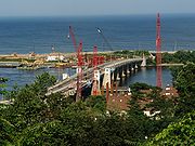
Route 36 turns west and crosses the Shrewsbury River on the four-lane Highlands-Sea Bright Bridge
, continuing into Highlands
. It intersects County Route 8 at an interchange and continues west on Navesink Avenue, a four-lane, divided highway with a Jersey barrier
and some intersections featuring jughandle
s that runs a short distance to the south of the Raritan Bay
. The route then forms the border between Highlands and Middletown Township
, with Highlands to the north and Middletown Township to the south. Route 36 intersects two separate sections of County Route 8, Linden Avenue and Ocean Boulevard soon after, before intersecting County Route 8B (Navesink Avenue) and fully entering Middletown Township. The name changes to Memorial Parkway and Route 36 crosses into Atlantic Highlands
. In Atlantic Highlands, the route intersects County Route 8A (Valley Drive East) and another section of County Route 8 (First Avenue). It crosses back into Middletown Township and meets the eastern terminus of County Route 516
(Leonardville Road).
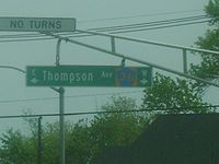 Route 36 passes under Normandy Road, which serves as a road and railroad link between the two sections of Naval Weapons Station Earle
, with an entrance present to Normandy Road. The route drops the Memorial Parkway name and meets County Route 36 (Thompson Avenue). It then crosses County Route 7 (Palmer Avenue/Main Street) and forms the border between Hazlet Township
to the south and Keansburg
to the north. Route 36 eventually fully enters Hazlet Township and intersects County Route 7 (Munroe Avenue) again. The route then forms the border between Hazlet Township to the south and Union Beach
to the north and passes over Natco Lake. It intersects County Route 39 (Union Avenue) and then County Route 6 (Stone Road), where Route 36 fully enters Hazlet Township again. The route crosses County Route 516 (Middle Avenue) and later enters Keyport
. Route 36 intersects County Route 4 (Broad Street) and continues to its terminus at an interchange with Route 35 and the Garden State Parkway
at Exit 117. The overall shape of Route 36 is that of a backwards C.
 Route 36 was established by the Laws of 1927, Chapter 319
to run between Keyport
and Highlands
. The route was to run up Broad Street from Front Street in Keyport, follow First Street east to the Second Street Bridge, and run east along Stone Road to Keansburg
. It would pass through Keansburg on Church Street and follow Shore Road east to the Belford
drawbridge and then on through more rural fields and meadows. Route 36 would head along Center Avenue from Ocean View to Atlantic Highlands
, where it would turn north on First Avenue and run east along Ocean Boulevard to Navesink Avenue in Highlands. The route would follow Navesink Avenue east to the drawbridge over the Shrewsbury River
. This routing as proposed was considered impractical as it consisted entirely of local roads, went through the downtown areas of Keyport, Keansburg and Atlantic Highlands, and contained many hazardous sharp curves. This was remedied in 1929, when Route 36 was designated to bypass the downtowns and sharp curves.
In 1940, Route 36 was extended south to Route 35 in Eatontown
, but only a portion was constructed in Eatontown and West Long Branch
. As a result, this extension remained unsigned in the 1953 New Jersey state highway renumbering
. Additional parts of this extension were taken over on October 17, 1972, with the takeover of County Route 9, which was Ocean Avenue between the Long Branch
/Monmouth Beach
border and the Sea Bright
/Middletown Township
border, and County Route 44, which was Joline Avenue between Branchport Avenue and Ocean Avenue in Long Branch. County Route 9 was initially taken over as a county highway
by resolution of the Monmouth County Board of Chosen Freeholders
on September 1, 1903 running from Rumson Road north to the Middletown Township border at Sandy Hook. It was extended to the southern border of Monmouth Beach by two resolutions dated February 4, 1920. County Route 44 was taken over as a county road on October 18, 1939. Following the takeover of County Routes 9 and 44, a short gap of Route 36 remained in Long Branch (Ocean Avenue between Joline Avenue and the Monmouth Beach border) that was municipally maintained; with the completion of Ocean Boulevard in late 1983 that link has been added.
Between 2008 and 2011, the Highlands-Sea Bright Bridge
, currently a drawbridge
, will be replaced with a fixed span 30 feet (9.1 m) higher than the current bridge.
is located along Route 36 in Belford
. Additionally, the "Quick Stop Groceries" and "RST Video" stores from the 1994 film Clerks
are located just north of the highway's intersection with Leonard Avenue in Leonardo
. Both films were created by former New Jersey
resident Kevin Smith
.
|-
!Location
!Mile
!Road(s)
!Notes
|-
|rowspan=4|Eatontown
|0.00
|
|Western terminus; GSP Exit 105
|-
|0.26
|
|Interchange; Westbound exit, eastbound entrance
|-
|1.27
|
|
|-
|1.54
|
|Former Eatontown Circle
|-
|rowspan=2|West Long Branch
|2.78
|
|
|-
|3.26
|
|
|-
|rowspan=2|Sea Bright
|9.37
|
|
|-
|11.48
|Gateway National Recreation Area
- Sandy Hook
|Interchange
|-
|rowspan=2|Highlands
|11.63
|colspan=5 align="center"|Highlands-Sea Bright Bridge
over Shrewsbury River
|-
|11.77
|
|Interchange
|-
|Middletown Township
|15.39
|
|
|-
|Hazlet Township
|23.59
|
|
|-
|Keyport
|24.40
|
|Northern terminus; Interchange; GSP Exit 117
|-
State highway
State highway, state road or state route can refer to one of three related concepts, two of them related to a state or provincial government in a country that is divided into states or provinces :#A...
in Monmouth County
Monmouth County, New Jersey
Monmouth County is a county located in the U.S. state of New Jersey, within the New York metropolitan area. As of the 2010 Census, the population was 630,380, up from 615,301 at the 2000 census. Its county seat is Freehold Borough. The most populous municipality is Middletown Township with...
, New Jersey
New Jersey
New Jersey is a state in the Northeastern and Middle Atlantic regions of the United States. , its population was 8,791,894. It is bordered on the north and east by the state of New York, on the southeast and south by the Atlantic Ocean, on the west by Pennsylvania and on the southwest by Delaware...
, United States
United States
The United States of America is a federal constitutional republic comprising fifty states and a federal district...
. The 24.4 miles (39.27 km) long route, shaped as a backwards C, begins at an intersection with Garden State Parkway
Garden State Parkway
The Garden State Parkway is a 172.4-mile limited-access toll parkway that stretches the length of New Jersey from the New York line at Montvale, New Jersey, to Cape May at New Jersey's southernmost tip. Its name refers to New Jersey's nickname, the "Garden State." Most New Jersey residents refer...
and County Route 51 (Hope Road) in Eatontown
Eatontown, New Jersey
Eatontown is a borough in Monmouth County, New Jersey, United States. As of the 2010 census, the borough population was 12,709.What is now Eatontown was originally incorporated as Eatontown Township by an Act of the New Jersey Legislature on April 4, 1873, from portions of Ocean Township and...
and runs east to Long Branch
Long Branch, New Jersey
Long Branch is a city in Monmouth County, New Jersey, United States. As of the 2010 United States Census, the city population was 30,719.Long Branch was formed on April 11, 1867, as the Long Branch Commission, from portions of Ocean Township...
. From Long Branch, the route follows the Atlantic Ocean
Atlantic Ocean
The Atlantic Ocean is the second-largest of the world's oceanic divisions. With a total area of about , it covers approximately 20% of the Earth's surface and about 26% of its water surface area...
north to Sea Bright
Sea Bright, New Jersey
Sea Bright is a borough in Monmouth County, New Jersey, United States. As of the 2010 United States Census, the borough population was 1,412.Sea Bright was formed as a borough by an act of the New Jersey Legislature on March 21, 1889, from portions of Ocean Township, based on the results of a...
and turns west, running to the south of the Raritan Bay
Raritan Bay
Raritan Bay is a bay located at the southern portion of Lower New York Bay between the U.S. states of New York and New Jersey and is part of the New York Bight. The bay is bounded on the northwest by New York's Staten Island, on the west by Perth Amboy, New Jersey, on the south by the Raritan...
. Route 36 ends in Keyport
Keyport, New Jersey
Keyport is a borough in Monmouth County, New Jersey, United States. As of the 2010 United States Census, the borough population was 7,240. Keyport's nickname is the "Pearl of the Bayshore" or the "Gateway to the Bayshore"....
at an interchange with the Garden State Parkway and Route 35. It varies in width from a six-lane divided highway
Divided Highway
Divided Highway is a compilation album by American rock band The Doobie Brothers, released in 2003. . All tracks are taken from the albums Cycles and Brotherhood .-Track listing:...
to a two-lane undivided road. The route is signed east–west between Eatontown and Long Branch and north–south between Long Branch and Keyport.
Route 36 was created in 1927 to run from Keyport to Highlands
Highlands, New Jersey
Highlands is a borough in Monmouth County, New Jersey, United States. As of the 2010 United States Census, the borough population was 5,005. It is the home town of film maker, director, and comic book writer Kevin Smith. The eastern part of the town is built on a high bluff that overlooks Sandy...
along a winding route that went through the downtowns of Keyport, Keansburg
Keansburg, New Jersey
Keansburg is a borough in Monmouth County, New Jersey, United States. As of the 2010 United States Census, the borough population was 10,105.Keansburg was formed as a borough by an act of the New Jersey Legislature on March 26, 1917, from portions of both Middletown Township and Raritan Township ,...
, and Atlantic Highlands
Atlantic Highlands, New Jersey
Atlantic Highlands is a Borough in Monmouth County, New Jersey in the Bayshore Region. As of the 2010 United States Census, the borough population was 4,385...
. In 1929, the route was modified to bypass the downtown areas. Route 36 was extended to Eatontown in 1940 with only the portion within Eatontown and West Long Branch
West Long Branch, New Jersey
West Long Branch is a borough in Monmouth County, New Jersey, United States. As of the 2010 United States Census, the borough population was 8,097. It is the home of Monmouth University....
built. The remainder of the route was created with the takeover of Joline Avenue in Long Branch and Ocean Avenue in Monmouth Beach
Monmouth Beach, New Jersey
Monmouth Beach is a borough in Monmouth County, New Jersey, United States. As of the 2010 United States Census, the borough population was 3,279....
and Sea Bright from Monmouth County on October 17, 1972 and the completion of Ocean Boulevard in Long Branch in late 1983.
Route description
Route 36 begins at the intersection with County Route 51 (Hope Road) and Exit 105 of the Garden State ParkwayGarden State Parkway
The Garden State Parkway is a 172.4-mile limited-access toll parkway that stretches the length of New Jersey from the New York line at Montvale, New Jersey, to Cape May at New Jersey's southernmost tip. Its name refers to New Jersey's nickname, the "Garden State." Most New Jersey residents refer...
in Eatontown
Eatontown, New Jersey
Eatontown is a borough in Monmouth County, New Jersey, United States. As of the 2010 census, the borough population was 12,709.What is now Eatontown was originally incorporated as Eatontown Township by an Act of the New Jersey Legislature on April 4, 1873, from portions of Ocean Township and...
, heading east along a four-lane divided highway
Divided Highway
Divided Highway is a compilation album by American rock band The Doobie Brothers, released in 2003. . All tracks are taken from the albums Cycles and Brotherhood .-Track listing:...
. Soon after beginning, it features ramps that provide access to Route 18 in the westbound direction and from Route 18 in the eastbound direction. The route widens to six lanes and crosses County Route 547
County Route 547 (New Jersey)
County Route 547, abbreviated CR 547, is a county highway in the U.S. state of New Jersey. The highway extends from Route 70 in Lakehurst to Broad Street in Eatontown...
(Wyckoff Road). After that intersection, Route 36 passes by the Monmouth Mall
Monmouth Mall
Monmouth Mall, an enclosed shopping center in Eatontown, New Jersey owned by Vornado Realty Trust, is located on the corner of the intersection of NJ 35, NJ 36, and Wyckoff Road . Currently, the mall has a gross leasable area of , making it the fourth largest shopping mall in New Jersey , boasting...
and intersects Route 35 at the former Eatontown Circle
Eatontown Circle
The Eatontown Circle was a traffic circle in Eatontown, New Jersey, located at the intersection of Route 35, Route 36, Wall Street, and near Wyckoff Road CR 547, near the Monmouth Mall. At the time of its construction, the southwest quadrant was built on a farm owned by the Valentino Family from...
, which has been reconstructed to an at-grade intersection with ramps. Route 36 continues east through commercial development and crosses into West Long Branch
West Long Branch, New Jersey
West Long Branch is a borough in Monmouth County, New Jersey, United States. As of the 2010 United States Census, the borough population was 8,097. It is the home of Monmouth University....
, where it comes to an intersection with Route 71. The route heads northeast, becoming Monmouth Park Highway, and crosses County Route 537
County Route 537 (New Jersey)
County Route 537, abbreviated CR 537, is a county highway in the U.S. state of New Jersey. The highway extends from Delaware Avenue in Camden to Myrtle Avenue in Long Branch.-Camden County:...
(Eatontown Boulevard/Broadway). Route 36 meets County Route 11 (Oceanport Avenue) and comes to the entrance to the Monmouth Park Racetrack
Monmouth Park Racetrack
Monmouth Park Racetrack is an American race track for thoroughbred horse racing in Oceanport, New Jersey. It is owned by the New Jersey Sports and Exposition Authority and is operated under a five-year lease as a partnership with Resorts Casino Hotel in Atlantic City.Monmouth Park's marquee event...
.
Route 36 narrows to a two-lane undivided highway and crosses into Long Branch
Long Branch, New Jersey
Long Branch is a city in Monmouth County, New Jersey, United States. As of the 2010 United States Census, the city population was 30,719.Long Branch was formed on April 11, 1867, as the Long Branch Commission, from portions of Ocean Township...
, where it becomes Joline Avenue. In Long Branch, the route crosses County Route 29 (Myrtle Avenue) and New Jersey Transit
New Jersey Transit
The New Jersey Transit Corporation is a statewide public transportation system serving the United States state of New Jersey, and New York, Orange, and Rockland counties in New York State...
’s North Jersey Coast Line
North Jersey Coast Line
The North Jersey Coast Line is a New Jersey Transit commuter rail service operating between New York Penn Station or Hoboken Terminal and Bay Head, New Jersey...
. Route 36 heads toward the Atlantic Ocean
Atlantic Ocean
The Atlantic Ocean is the second-largest of the world's oceanic divisions. With a total area of about , it covers approximately 20% of the Earth's surface and about 26% of its water surface area...
, where at the intersection with County Route 57 (Ocean Boulevard), the route turns north and runs along the Atlantic Ocean on Ocean Boulevard, a four-lane divided road. Route 36 intersects County Route 29 (Atlantic Avenue) and crosses into Monmouth Beach
Monmouth Beach, New Jersey
Monmouth Beach is a borough in Monmouth County, New Jersey, United States. As of the 2010 United States Census, the borough population was 3,279....
, where it narrows to a two-lane undivided road and takes on the name Ocean Avenue. It continues through Monmouth Beach and enters Sea Bright
Sea Bright, New Jersey
Sea Bright is a borough in Monmouth County, New Jersey, United States. As of the 2010 United States Census, the borough population was 1,412.Sea Bright was formed as a borough by an act of the New Jersey Legislature on March 21, 1889, from portions of Ocean Township, based on the results of a...
, where Route 36 heads north onto a narrow peninsula between the Shrewsbury River
Shrewsbury River
The Shrewsbury River is a short stream and navigable estuary, approximately 8 mi long, in central New Jersey in the United States....
and the Atlantic Ocean, meeting the eastern terminus of County Route 520
County Route 520 (New Jersey)
County Route 520 is a county highway in the U.S. state of New Jersey. County Route 520 is a major road across Monmouth County connecting the county's central towns to the Jersey Shore at Sea Bright.-Route description:...
(Rumson Road). The route continues north along the peninsula to a trumpet interchange that provides access to Gateway National Recreation Area
Gateway National Recreation Area
Gateway National Recreation Area is a National Recreation Area in the Port of New York and New Jersey. Scattered over Brooklyn, Queens, and Staten Island, New York and Monmouth County, New Jersey, it provides recreational opportunities that are rare for a dense urban environment, including ocean...
at Sandy Hook
Sandy Hook
Sandy Hook is a barrier spit along the Atlantic coast of New JerseySandy Hook may also refer to:-Places:United States* Sandy Hook , a village in the town of Newtown, Connecticut* Sandy Hook, Kentucky, a city in Elliott County...
.
Route 36 turns west and crosses the Shrewsbury River on the four-lane Highlands-Sea Bright Bridge
Highlands-Sea Bright Bridge
The Highlands-Sea Bright Bridge was a 1,240-foot drawbridge, built in 1932, to connect Highlands, New Jersey in the west to Sea Bright, New Jersey in the east, across the Shrewsbury River. The eastern terminus is at the entrance to Sandy Hook. The span is part of Route 36. Between 2008 and 2011 it...
, continuing into Highlands
Highlands, New Jersey
Highlands is a borough in Monmouth County, New Jersey, United States. As of the 2010 United States Census, the borough population was 5,005. It is the home town of film maker, director, and comic book writer Kevin Smith. The eastern part of the town is built on a high bluff that overlooks Sandy...
. It intersects County Route 8 at an interchange and continues west on Navesink Avenue, a four-lane, divided highway with a Jersey barrier
Jersey barrier
A Jersey barrier or Jersey wall is a modular concrete barrier employed to separate lanes of traffic. It is designed to both minimize vehicle damage in cases of incidental contact while still preventing crossover in the case of head-on accidents....
and some intersections featuring jughandle
Jughandle
A jughandle is a type of ramp or slip road that changes the way traffic turns left at at-grade intersections. Instead of a standard left turn being made from the left lane, left-turning traffic uses a ramp on the right side of the road...
s that runs a short distance to the south of the Raritan Bay
Raritan Bay
Raritan Bay is a bay located at the southern portion of Lower New York Bay between the U.S. states of New York and New Jersey and is part of the New York Bight. The bay is bounded on the northwest by New York's Staten Island, on the west by Perth Amboy, New Jersey, on the south by the Raritan...
. The route then forms the border between Highlands and Middletown Township
Middletown Township, New Jersey
Middletown Township is a township in Monmouth County, New Jersey, United States. As of the 2010 United States Census, the township had a total population of 66,522...
, with Highlands to the north and Middletown Township to the south. Route 36 intersects two separate sections of County Route 8, Linden Avenue and Ocean Boulevard soon after, before intersecting County Route 8B (Navesink Avenue) and fully entering Middletown Township. The name changes to Memorial Parkway and Route 36 crosses into Atlantic Highlands
Atlantic Highlands, New Jersey
Atlantic Highlands is a Borough in Monmouth County, New Jersey in the Bayshore Region. As of the 2010 United States Census, the borough population was 4,385...
. In Atlantic Highlands, the route intersects County Route 8A (Valley Drive East) and another section of County Route 8 (First Avenue). It crosses back into Middletown Township and meets the eastern terminus of County Route 516
County Route 516 (New Jersey)
-Route description:The highway extends 19.27 miles from Route 18/CR 527 in Old Bridge Township to Route 36 in Middletown Township. It is known as Old Bridge-Matawan Road for its entire length in Old Bridge Township where it intersects US 9 then continues several more miles to the Old...
(Leonardville Road).
Naval Weapons Station Earle
Naval Weapons Station Earle is a United States Navy base in New Jersey. Its distinguishing feature is a 2.9-mile pier in Sandy Hook Bay where ammunition can be loaded and unloaded from warships at a safe distance from land....
, with an entrance present to Normandy Road. The route drops the Memorial Parkway name and meets County Route 36 (Thompson Avenue). It then crosses County Route 7 (Palmer Avenue/Main Street) and forms the border between Hazlet Township
Hazlet, New Jersey
Hazlet Township is a township in Monmouth County, New Jersey, United States. As of the 2010 United States Census, the township population was 20,334....
to the south and Keansburg
Keansburg, New Jersey
Keansburg is a borough in Monmouth County, New Jersey, United States. As of the 2010 United States Census, the borough population was 10,105.Keansburg was formed as a borough by an act of the New Jersey Legislature on March 26, 1917, from portions of both Middletown Township and Raritan Township ,...
to the north. Route 36 eventually fully enters Hazlet Township and intersects County Route 7 (Munroe Avenue) again. The route then forms the border between Hazlet Township to the south and Union Beach
Union Beach, New Jersey
Union Beach is a borough in Monmouth County, New Jersey, United States. As of the 2010 United States Census, the borough population was 6,245....
to the north and passes over Natco Lake. It intersects County Route 39 (Union Avenue) and then County Route 6 (Stone Road), where Route 36 fully enters Hazlet Township again. The route crosses County Route 516 (Middle Avenue) and later enters Keyport
Keyport, New Jersey
Keyport is a borough in Monmouth County, New Jersey, United States. As of the 2010 United States Census, the borough population was 7,240. Keyport's nickname is the "Pearl of the Bayshore" or the "Gateway to the Bayshore"....
. Route 36 intersects County Route 4 (Broad Street) and continues to its terminus at an interchange with Route 35 and the Garden State Parkway
Garden State Parkway
The Garden State Parkway is a 172.4-mile limited-access toll parkway that stretches the length of New Jersey from the New York line at Montvale, New Jersey, to Cape May at New Jersey's southernmost tip. Its name refers to New Jersey's nickname, the "Garden State." Most New Jersey residents refer...
at Exit 117. The overall shape of Route 36 is that of a backwards C.
History
1927 New Jersey state highway renumbering
In 1927, New Jersey's state highways were renumbered. The old system, which had been defined in sequence by the legislature, was growing badly, as several routes shared the same number, and many unnumbered state highways had been defined...
to run between Keyport
Keyport, New Jersey
Keyport is a borough in Monmouth County, New Jersey, United States. As of the 2010 United States Census, the borough population was 7,240. Keyport's nickname is the "Pearl of the Bayshore" or the "Gateway to the Bayshore"....
and Highlands
Highlands, New Jersey
Highlands is a borough in Monmouth County, New Jersey, United States. As of the 2010 United States Census, the borough population was 5,005. It is the home town of film maker, director, and comic book writer Kevin Smith. The eastern part of the town is built on a high bluff that overlooks Sandy...
. The route was to run up Broad Street from Front Street in Keyport, follow First Street east to the Second Street Bridge, and run east along Stone Road to Keansburg
Keansburg, New Jersey
Keansburg is a borough in Monmouth County, New Jersey, United States. As of the 2010 United States Census, the borough population was 10,105.Keansburg was formed as a borough by an act of the New Jersey Legislature on March 26, 1917, from portions of both Middletown Township and Raritan Township ,...
. It would pass through Keansburg on Church Street and follow Shore Road east to the Belford
Belford, New Jersey
Belford is a census-designated place and unincorporated area located within Middletown Township, in Monmouth County, New Jersey. As of the 2010 United States Census, the CDP population was 1,768.-Ferry:...
drawbridge and then on through more rural fields and meadows. Route 36 would head along Center Avenue from Ocean View to Atlantic Highlands
Atlantic Highlands, New Jersey
Atlantic Highlands is a Borough in Monmouth County, New Jersey in the Bayshore Region. As of the 2010 United States Census, the borough population was 4,385...
, where it would turn north on First Avenue and run east along Ocean Boulevard to Navesink Avenue in Highlands. The route would follow Navesink Avenue east to the drawbridge over the Shrewsbury River
Shrewsbury River
The Shrewsbury River is a short stream and navigable estuary, approximately 8 mi long, in central New Jersey in the United States....
. This routing as proposed was considered impractical as it consisted entirely of local roads, went through the downtown areas of Keyport, Keansburg and Atlantic Highlands, and contained many hazardous sharp curves. This was remedied in 1929, when Route 36 was designated to bypass the downtowns and sharp curves.
In 1940, Route 36 was extended south to Route 35 in Eatontown
Eatontown, New Jersey
Eatontown is a borough in Monmouth County, New Jersey, United States. As of the 2010 census, the borough population was 12,709.What is now Eatontown was originally incorporated as Eatontown Township by an Act of the New Jersey Legislature on April 4, 1873, from portions of Ocean Township and...
, but only a portion was constructed in Eatontown and West Long Branch
West Long Branch, New Jersey
West Long Branch is a borough in Monmouth County, New Jersey, United States. As of the 2010 United States Census, the borough population was 8,097. It is the home of Monmouth University....
. As a result, this extension remained unsigned in the 1953 New Jersey state highway renumbering
1953 New Jersey state highway renumbering
On January 1, 1953, the New Jersey Department of Transportation renumbered many of the State Routes. A few rules were followed in deciding what to renumber:...
. Additional parts of this extension were taken over on October 17, 1972, with the takeover of County Route 9, which was Ocean Avenue between the Long Branch
Long Branch, New Jersey
Long Branch is a city in Monmouth County, New Jersey, United States. As of the 2010 United States Census, the city population was 30,719.Long Branch was formed on April 11, 1867, as the Long Branch Commission, from portions of Ocean Township...
/Monmouth Beach
Monmouth Beach, New Jersey
Monmouth Beach is a borough in Monmouth County, New Jersey, United States. As of the 2010 United States Census, the borough population was 3,279....
border and the Sea Bright
Sea Bright, New Jersey
Sea Bright is a borough in Monmouth County, New Jersey, United States. As of the 2010 United States Census, the borough population was 1,412.Sea Bright was formed as a borough by an act of the New Jersey Legislature on March 21, 1889, from portions of Ocean Township, based on the results of a...
/Middletown Township
Middletown Township, New Jersey
Middletown Township is a township in Monmouth County, New Jersey, United States. As of the 2010 United States Census, the township had a total population of 66,522...
border, and County Route 44, which was Joline Avenue between Branchport Avenue and Ocean Avenue in Long Branch. County Route 9 was initially taken over as a county highway
County highway
A county highway is a road in the United States and in the Canadian province of Ontario that is designated and/or maintained by the county highway department...
by resolution of the Monmouth County Board of Chosen Freeholders
Board of Chosen Freeholders
In New Jersey, the Boards of Chosen Freeholders are the county legislatures in each of that state's 21 counties.- Origin :New Jersey's system of naming county legislators "freeholders" is unique in the United States...
on September 1, 1903 running from Rumson Road north to the Middletown Township border at Sandy Hook. It was extended to the southern border of Monmouth Beach by two resolutions dated February 4, 1920. County Route 44 was taken over as a county road on October 18, 1939. Following the takeover of County Routes 9 and 44, a short gap of Route 36 remained in Long Branch (Ocean Avenue between Joline Avenue and the Monmouth Beach border) that was municipally maintained; with the completion of Ocean Boulevard in late 1983 that link has been added.
Between 2008 and 2011, the Highlands-Sea Bright Bridge
Highlands-Sea Bright Bridge
The Highlands-Sea Bright Bridge was a 1,240-foot drawbridge, built in 1932, to connect Highlands, New Jersey in the west to Sea Bright, New Jersey in the east, across the Shrewsbury River. The eastern terminus is at the entrance to Sandy Hook. The span is part of Route 36. Between 2008 and 2011 it...
, currently a drawbridge
Drawbridge
A drawbridge is a type of movable bridge typically associated with the entrance of a castle surrounded by a moat. The term is often used to describe all different types of movable bridges, like bascule bridges and lift bridges.-Castle drawbridges:...
, will be replaced with a fixed span 30 feet (9.1 m) higher than the current bridge.
In popular culture
The "Marina Diner" from the 1997 film Chasing AmyChasing Amy
Chasing Amy is a 1997 romantic comedy film written and directed by Kevin Smith. The central tension revolves around sexuality, sexual history, and evolving friendships. It is the third film in Smith's View Askewniverse series....
is located along Route 36 in Belford
Belford, New Jersey
Belford is a census-designated place and unincorporated area located within Middletown Township, in Monmouth County, New Jersey. As of the 2010 United States Census, the CDP population was 1,768.-Ferry:...
. Additionally, the "Quick Stop Groceries" and "RST Video" stores from the 1994 film Clerks
Clerks
Clerks is a 1994 independent comedy film written and directed by Kevin Smith, who also appears in the film as Silent Bob. Starring Brian O'Halloran as Dante Hicks and Jeff Anderson as Randal Graves, it presents a day in the lives of two store clerks and their acquaintances...
are located just north of the highway's intersection with Leonard Avenue in Leonardo
Leonardo, New Jersey
Leonardo is a census-designated place located within Middletown Township, in Monmouth County, New Jersey. As of the 2010 United States Census, the CDP population was 2,757...
. Both films were created by former New Jersey
New Jersey
New Jersey is a state in the Northeastern and Middle Atlantic regions of the United States. , its population was 8,791,894. It is bordered on the north and east by the state of New York, on the southeast and south by the Atlantic Ocean, on the west by Pennsylvania and on the southwest by Delaware...
resident Kevin Smith
Kevin Smith
Kevin Patrick Smith is an American screenwriter, actor, film producer, and director, as well as a popular comic book writer, author, comedian/raconteur, and internet radio personality best recognized by viewers as Silent Bob...
.
Major intersections
{| class=wikitable|-
!Location
!Mile
!Road(s)
!Notes
|-
|rowspan=4|Eatontown
Eatontown, New Jersey
Eatontown is a borough in Monmouth County, New Jersey, United States. As of the 2010 census, the borough population was 12,709.What is now Eatontown was originally incorporated as Eatontown Township by an Act of the New Jersey Legislature on April 4, 1873, from portions of Ocean Township and...
|0.00
|
|Western terminus; GSP Exit 105
|-
|0.26
|
|Interchange; Westbound exit, eastbound entrance
|-
|1.27
|
|
|-
|1.54
|
|Former Eatontown Circle
Eatontown Circle
The Eatontown Circle was a traffic circle in Eatontown, New Jersey, located at the intersection of Route 35, Route 36, Wall Street, and near Wyckoff Road CR 547, near the Monmouth Mall. At the time of its construction, the southwest quadrant was built on a farm owned by the Valentino Family from...
|-
|rowspan=2|West Long Branch
West Long Branch, New Jersey
West Long Branch is a borough in Monmouth County, New Jersey, United States. As of the 2010 United States Census, the borough population was 8,097. It is the home of Monmouth University....
|2.78
|
|
|-
|3.26
|
|
|-
|rowspan=2|Sea Bright
Sea Bright, New Jersey
Sea Bright is a borough in Monmouth County, New Jersey, United States. As of the 2010 United States Census, the borough population was 1,412.Sea Bright was formed as a borough by an act of the New Jersey Legislature on March 21, 1889, from portions of Ocean Township, based on the results of a...
|9.37
|
|
|-
|11.48
|Gateway National Recreation Area
Gateway National Recreation Area
Gateway National Recreation Area is a National Recreation Area in the Port of New York and New Jersey. Scattered over Brooklyn, Queens, and Staten Island, New York and Monmouth County, New Jersey, it provides recreational opportunities that are rare for a dense urban environment, including ocean...
- Sandy Hook
Sandy Hook
Sandy Hook is a barrier spit along the Atlantic coast of New JerseySandy Hook may also refer to:-Places:United States* Sandy Hook , a village in the town of Newtown, Connecticut* Sandy Hook, Kentucky, a city in Elliott County...
|Interchange
|-
|rowspan=2|Highlands
Highlands, New Jersey
Highlands is a borough in Monmouth County, New Jersey, United States. As of the 2010 United States Census, the borough population was 5,005. It is the home town of film maker, director, and comic book writer Kevin Smith. The eastern part of the town is built on a high bluff that overlooks Sandy...
|11.63
|colspan=5 align="center"|Highlands-Sea Bright Bridge
Highlands-Sea Bright Bridge
The Highlands-Sea Bright Bridge was a 1,240-foot drawbridge, built in 1932, to connect Highlands, New Jersey in the west to Sea Bright, New Jersey in the east, across the Shrewsbury River. The eastern terminus is at the entrance to Sandy Hook. The span is part of Route 36. Between 2008 and 2011 it...
over Shrewsbury River
Shrewsbury River
The Shrewsbury River is a short stream and navigable estuary, approximately 8 mi long, in central New Jersey in the United States....
|-
|11.77
|
|Interchange
|-
|Middletown Township
Middletown Township, New Jersey
Middletown Township is a township in Monmouth County, New Jersey, United States. As of the 2010 United States Census, the township had a total population of 66,522...
|15.39
|
|
|-
|Hazlet Township
Hazlet, New Jersey
Hazlet Township is a township in Monmouth County, New Jersey, United States. As of the 2010 United States Census, the township population was 20,334....
|23.59
|
|
|-
|Keyport
Keyport, New Jersey
Keyport is a borough in Monmouth County, New Jersey, United States. As of the 2010 United States Census, the borough population was 7,240. Keyport's nickname is the "Pearl of the Bayshore" or the "Gateway to the Bayshore"....
|24.40
|
|Northern terminus; Interchange; GSP Exit 117
|-