

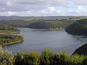
Roadstead of Brest
Encyclopedia
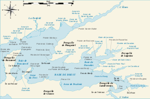
Roadstead
A roadstead is a place outside a harbor where a ship can lie at anchor. It is an enclosed area with an opening to the sea, narrower than a bay or gulf. It has a surface that cannot be confused with an estuary. It can be created artificially by jetties or dikes...
or bay
Bay
A bay is an area of water mostly surrounded by land. Bays generally have calmer waters than the surrounding sea, due to the surrounding land blocking some waves and often reducing winds. Bays also exist as an inlet in a lake or pond. A large bay may be called a gulf, a sea, a sound, or a bight...
located in the Finistère
Finistère
Finistère is a département of France, in the extreme west of Brittany.-History:The name Finistère derives from the Latin Finis Terræ, meaning end of the earth, and may be compared with Land's End on the opposite side of the English Channel...
department in Brittany in northwestern France
France
The French Republic , The French Republic , The French Republic , (commonly known as France , is a unitary semi-presidential republic in Western Europe with several overseas territories and islands located on other continents and in the Indian, Pacific, and Atlantic oceans. Metropolitan France...
. The surface area is about 180 km² (70 sq mi). The port of Brest is located on its northern edge and one of the two French naval base
Naval base
A naval base is a military base, where warships and naval ships are deployed when they have no mission at sea or want to restock. Usually ships may also perform some minor repairs. Some naval bases are temporary homes to aircraft that usually stay on the ships but are undergoing maintenance while...
s. It is linked to the Atlantic Ocean
Atlantic Ocean
The Atlantic Ocean is the second-largest of the world's oceanic divisions. With a total area of about , it covers approximately 20% of the Earth's surface and about 26% of its water surface area...
(called the Iroise Sea
Iroise Sea
The Iroise Sea or Mer d'Iroise is the part of the Atlantic Ocean which stretches from the Ile de Sein to Ushant off the coast of Brittany in north-western France. It borders on the English Channel to the north, the Celtic Sea to the west and the Bay of Biscay to the south. The origin of the name is...
at this point) by the Goulet de Brest
Goulet de Brest
The Goulet de Brest is a 3 km long strait linking the roadstead of Brest to the Atlantic Ocean. Only 1.8 km wide, it is situated between the Pointe du Petit Minou and the Pointe du Portzic to the north and the îlot des Capucins and the Pointe des Espagnols to the south.At each turn of...
, a strait
Strait
A strait or straits is a narrow, typically navigable channel of water that connects two larger, navigable bodies of water. It most commonly refers to a channel of water that lies between two land masses, but it may also refer to a navigable channel through a body of water that is otherwise not...
about 1.8 km wide. Three main rivers drain into the roadstead: the Penfeld
Penfeld
The Penfeld, Penfell in Breton, is a 16 km-long French coastal river. On its left bank has grown up the town of Brest in Finistère.-Course:...
(the first buildings of the naval base were built on
its banks), the Élorn
Élorn
The Élorn is a 56 km long river in Brittany, France. Its source is in the monts d'Arrée, 1.5km NNE of Le Tuchenn Kador, and it then runs through several small towns such as Sizun and Landivisiau before flowing out into the roadstead of Brest. This river is the birhplace of the legendary Dragon...
(or river of Landerneau
Landerneau
Landerneau is a commune in the Finistère department of Brittany in north-western France.It lies at the mouth of the Elorn River which divides the Breton provinces of Cornouaille and Léon, east of Brest...
) and the Aulne
Aulne
The Aulne is a 140 km long river of Brittany in north-western France, flowing down the hills and emptying into the roadstead of Brest, one of the many fjord-like bays just south of Brest. The river is part of the Canal de Nantes à Brest, the navigation canal that once connected the city of Nantes...
(or river of Châteaulin
Châteaulin
Châteaulin is a commune in the Finistère department in the region of Brittany in north-western France. It is a sub-prefecture of the department.-Geography:...
).
Strategic importance
For a number of centuries, Brest has been an important military port. The roadstead of Brest therefore has a number of military installations, for example:- Brest arsenal, on the north of the bay;
- the submarine base of the Île LongueÎle LongueÎle Longue is a peninsula of the roadstead of Brest. It is the base of the SNLE, the French ballistic missile submarines, and as such one of the most secretive and heavily defended places in France.-Geography:...
, to the south-west; - the École NavaleÉcole NavaleThe École Navale is the French Naval Academy in charge of the education of the officers of the French Navy.The academy was founded in 1830 by the order of King Louis-Philippe...
naval college and the Poulmic association of schools at LanvéocLanvéocLanvéoc is a commune in the Finistère department of Brittany in north-western France. The École Navale, the French naval academy, is located here.-References:** ;-External links:* *...
; - the naval 'graveyard' for ships at LandévennecLandévennecLandévennec is a commune in the Finistère department of Brittany in north-western France.-Ship graveyard:Shortly before entering the roadstead of Brest, the river Aulne forms a bend around the Île de Térénez then the pointe de Pen Forn near Landévennec, where there is 10m depth of water regardless...
.
One can also find many remains of old military fortifications and other ruins from past centuries, like the forts at Portzic
Fort de Portzic
The Fort de Portzic was built near the town of Brest by Vauban between 1693 and 1699 as part of the defences of the goulet de Brest. It faces the pointe des Espagnols and was improved and enlarged over time , since it formed the town's last and innermost defence...
, at pointe des Espagnols
Pointe des Espagnols
The Pointe des Espagnols is the north-east extremity of the Roscanvel peninsula, an outgrowth of the Crozon peninsula closing off the roadstead of Brest...
, etc.
Islands within the roadstead of Brest
- Plougastel Daoulas
- Île RondeÎle Ronde, BrestThe Île Ronde is a French islet 400m to the south west of Pointe de l’Armorique, in the roadstead of Brest, within the territory of the commune of Plougastel-Daoulas. Its highest point is 24m...
- Île Ronde
- Logonna Daoulas
- Île de la Pointe du Château
- Îles du Bindy
- Hôpital-CamfroutHôpital-CamfroutHôpital-Camfrout is a commune in the Finistère department of Brittany in north-western France.-Population:Inhabitants of Hôpital-Camfrout are called in French Hospitaliers or Camfroutois.-References:** ;-External links:* *...
- Île de TibidyÎle de TibidyTibidy is a French islet at the mouth of the river Faou, at the bottom of the roadstead of Brest, on land belonging to the commune of L'Hôpital-Camfrout. Its highest point is 15m...
- Île de Tibidy
- RosnoënRosnoënRosnoën is a commune in the Finistère department of Brittany in north-western France.-Population:Inhabitants of Rosnoën are called in French Rosnoënais.-References:** -External links:* *...
- Île d'ArunÎle d'ArunThe Île d'Arun is an islet in the confluence of the rivers Aulne and Le Faou, at the base of the roadstead of Brest. It is located in the territory of the commune of Rosnoën in Finistère, France, and its highest point above sea level is 11m. Accessible by a land route, it was the stopping-off...
- Île de TérénezÎle de TérénezÎle de Térénez is a French islet inside the last bend of the river Aulne, on the territory of the commune of Rosnoën. Its highest point is 18m....
- Île d'Arun
- CrozonCrozonCrozon is a commune in the Finistère department of Brittany in north-western France.Crozon is located on the Crozon peninsula on the west coast of Finistère. It is bordered by the communes of Camaret-sur-Mer to the west, Roscanvel to the northwest, Lanvéoc to the north, Landévennec to the...
- Île LongueÎle LongueÎle Longue is a peninsula of the roadstead of Brest. It is the base of the SNLE, the French ballistic missile submarines, and as such one of the most secretive and heavily defended places in France.-Geography:...
- Île du Renard
- Île Trébéron
- Île des MortsÎle des MortsÎle des Morts is a 7-hectare island in the Bay of Roscanvel, to the south-west of the roadstead of Brest, between the Quélern peninsula and Île Longue. It is 26m above sea level at its highest point.-History:...
- Île Perdue
- Île Longue
Rivers flowing into the roadstead of Brest
- PenfeldPenfeldThe Penfeld, Penfell in Breton, is a 16 km-long French coastal river. On its left bank has grown up the town of Brest in Finistère.-Course:...
; - ÉlornÉlornThe Élorn is a 56 km long river in Brittany, France. Its source is in the monts d'Arrée, 1.5km NNE of Le Tuchenn Kador, and it then runs through several small towns such as Sizun and Landivisiau before flowing out into the roadstead of Brest. This river is the birhplace of the legendary Dragon...
; - the river of DaoulasDaoulasDaoulas is a commune in the Finistère department of Brittany in north-western France.-Population:Inhabitants of Daoulas are called in French Daoulasiens.-References:** ;-External links:**...
; - AulneAulneThe Aulne is a 140 km long river of Brittany in north-western France, flowing down the hills and emptying into the roadstead of Brest, one of the many fjord-like bays just south of Brest. The river is part of the Canal de Nantes à Brest, the navigation canal that once connected the city of Nantes...
; - the river of FaouLe FaouLe Faou is a commune in the Finistère department in Bretagne in northwestern France.-Population:Inhabitants of Le Faou are called Faouistes.-Events:...
.
Environment
Thanks to its layout, the roadstead harbours a wide diversity of natural habitats and a high level of biodiversity. It also includes many sites of importance for birds, several networks of habitats and underwater corridors and coastal areas of importance. These areas have been greatly affected by the human activities in the north-west, but have justified the classification of around half of the roadstead as a zone in Natura 2000Natura 2000
Natura 2000 is an ecological network of protected areas in the territory of the European Union.-Origins:In May 1992, the governments of the European Communities adopted legislation designed to protect the most seriously threatened habitats and species across Europe. This legislation is called the...
.
Pollution
The rich ecology of the roadstead has been diminished by the past exploitation of certain resources, and by the presence of a number of pollutants including heavy metals and tributyltinTributyltin
Tributyltin compounds are a group of compounds containing the 3Sn moiety, such as tributyltin hydride or tributyltin oxide. They are the main active ingredients in certain biocides used to control a broad spectrum of organisms...
which were used as biocide
Biocide
A biocide is a chemical substance or microorganism which can deter, render harmless, or exert a controlling effect on any harmful organism by chemical or biological means. Biocides are commonly used in medicine, agriculture, forestry, and industry...
s in anti-fouling bottom paint
Bottom paint
Anti-fouling paint or bottom paint is a specialized coating applied to the hull of a ship or boat in order to slow the growth of organisms that attach to the hull and can affect a vessel's performance and durability...
s. These products are now illegal, but they remain present in sediments and certain organisms. The products which have replaced them for small boats (e.g. Diuron and Irgarol) pose similar problems and have been measured in non-negligible quantities in the roadstead by Ifremer
Ifremer
Ifremer, standing for French Research Institute for Exploitation of the Sea is an oceanographic institution in France.- Scope of works :...
in 2003-2004.
The roadstead is also a victim of the after-effects of war, and in particular the waves of pollution from the First and the Second World Wars. Pollutants trapped in submerged or unexploded munitions are expected to aggravate existing pollution with the first large leaks predicted by experts to occur in the years 2000-2010.