

River bifurcation
Encyclopedia
Stream
A stream is a body of water with a current, confined within a bed and stream banks. Depending on its locale or certain characteristics, a stream may be referred to as a branch, brook, beck, burn, creek, "crick", gill , kill, lick, rill, river, syke, bayou, rivulet, streamage, wash, run or...
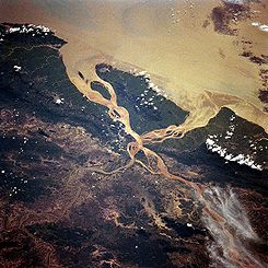
separates into two or more separate streams (called distributaries
Distributary
A distributary, or a distributary channel, is a stream that branches off and flows away from a main stream channel. They are a common feature of river deltas. The phenomenon is known as river bifurcation. The opposite of a distributary is a tributary...
) which continue downstream. Some rivers form complex networks of distributaries, especially in their deltas. If the streams eventually merge again or empty into the same body of water, then the bifurcation forms an island
Island
An island or isle is any piece of sub-continental land that is surrounded by water. Very small islands such as emergent land features on atolls can be called islets, cays or keys. An island in a river or lake may be called an eyot , or holm...
.
River bifurcation may be temporary or semi-permanent, depending on the strength of the material which separates the distributaries. For example, a mid-stream island of soil or silt in a delta is most likely temporary. A location where a river divides around a rock fin, e.g. a volcanically formed Dike
Dike (geology)
A dike or dyke in geology is a type of sheet intrusion referring to any geologic body that cuts discordantly across* planar wall rock structures, such as bedding or foliation...
, or a mountain, may be more lasting. A bifurcation may also be man-made, for example when two streams are separated by a long bridge
Bridge
A bridge is a structure built to span physical obstacles such as a body of water, valley, or road, for the purpose of providing passage over the obstacle...
pier.
Examples
One example of a natural bifurcation is the Casiquiare canalCasiquiare canal
The Casiquiare river is a distributary of the upper Orinoco flowing southward into the Rio Negro, in Venezuela, South America. As such, it forms a unique natural canal between the Orinoco and Amazon river systems. It is the largest river on the planet that links two major river systems, a...
that links the Orinoco River with the Amazon
Amazon River
The Amazon of South America is the second longest river in the world and by far the largest by waterflow with an average discharge greater than the next seven largest rivers combined...
.
Another occurrence of a river bifurcation was in Serbia
Serbia
Serbia , officially the Republic of Serbia , is a landlocked country located at the crossroads of Central and Southeast Europe, covering the southern part of the Carpathian basin and the central part of the Balkans...
, Europe in the Nerodimka River. The Nerodime Bifurcation was a hydrological curiosity: separate streams flowed into the Aegean
Aegean Sea
The Aegean Sea[p] is an elongated embayment of the Mediterranean Sea located between the southern Balkan and Anatolian peninsulas, i.e., between the mainlands of Greece and Turkey. In the north, it is connected to the Marmara Sea and Black Sea by the Dardanelles and Bosporus...
and the Black Sea
Black Sea
The Black Sea is bounded by Europe, Anatolia and the Caucasus and is ultimately connected to the Atlantic Ocean via the Mediterranean and the Aegean seas and various straits. The Bosphorus strait connects it to the Sea of Marmara, and the strait of the Dardanelles connects that sea to the Aegean...
s. The Bifurcation was located in the southern part of the Kosovo territory of Uroševac
Uroševac
Ferizaj or Uroševac is a city and municipality in southern Kosovo, located some south of the capital Pristina.Uroševac is the third most populous city in Kosovo, after Pristina and Prizren.It is the administrative centre of the homonymous district...
Municipality. The Bifurcation of Nerodimka was the first hydrological protected object in Serbia (1979). The Nerodimka Bifurcation is a strict wildlife sanctuary, category I according to (IUCN), with an area of 13.0 ha (about 32 acres). This bifurcation is considered to be an artificial phenomenon, but created under extremely favorable natural conditions.
In the past, the small Kalaus River in south-western Russia, when reaching the thalweg
Thalweg
Thalweg in geography and fluvial geomorphology signifies the deepest continuous inline within a valley or watercourse system.-Hydrology:In hydrological and fluvial landforms, the thalweg is a line drawn to join the lowest points along the entire length of a stream bed or valley in its downward...
of the Kuma-Manych Depression at 45°43′N 44°06′E, would split, the two distributaries becoming the headwaters of the West and East Manych Rivers
Manych River
Manych is a river in the western and central part of the Kuma-Manych Depression in southern Russia.Tributary to the river Don. The river is 219 km long; its source is Lake Manych-Gudilo in the south-westerm part of the Russian republic of Kalmykia...
. The former flows west into the Don River
Don River (Russia)
The Don River is one of the major rivers of Russia. It rises in the town of Novomoskovsk 60 kilometres southeast from Tula, southeast of Moscow, and flows for a distance of about 1,950 kilometres to the Sea of Azov....
and eventually into the Sea of Azov
Sea of Azov
The Sea of Azov , known in Classical Antiquity as Lake Maeotis, is a sea on the south of Eastern Europe. It is linked by the narrow Strait of Kerch to the Black Sea to the south and is bounded on the north by Ukraine mainland, on the east by Russia, and on the west by the Ukraine's Crimean...
, while the latter flows east, and is lost in the steppe before ever reaching the Caspian Sea
Caspian Sea
The Caspian Sea is the largest enclosed body of water on Earth by area, variously classed as the world's largest lake or a full-fledged sea. The sea has a surface area of and a volume of...
. However a dam was built, preventing water from flowing from the Kalaus into the East Manych; thus the Kalaus is now the source of the West Manych only.
The Bahr Yussef
Bahr Yussef
The Bahr Yussef, which roughly translates from Arabic as "the waterway of Joseph", is a canal which connects the Nile River with Fayyum in Egypt. This was originally in prehistoric times a natural offshoot of the Nile which created a lake to the west during high floods. Beginning with the 12th...
is a channel which splits off the west side of the Nile
Nile
The Nile is a major north-flowing river in North Africa, generally regarded as the longest river in the world. It is long. It runs through the ten countries of Sudan, South Sudan, Burundi, Rwanda, Democratic Republic of the Congo, Tanzania, Kenya, Ethiopia, Uganda and Egypt.The Nile has two major...
and drains into the Birket Qarun, an inland sea
Inland sea
An inland sea is a shallow sea that covers central areas of continents during periods of high sea level that result in marine transgressions. In modern times, continents stand high, eustatic sea levels are low, and there are few inland seas, none larger than the Caspian Sea...
in the Fayum Depression. Originally a natural bifurcation for flood waters, its flow was increased by canalisation in the 12th Dynasty (about 1900 BC). Around 230BC, the channel of the Nile from which it came (itself a bifurcation) dried up, but has since been fed by a new canal to allow water again to make it from the Nile to Al Fayyum
Al Fayyum
Faiyum is a city in Middle Egypt. Located 130 km southwest of Cairo, it is the capital of the modern Faiyum Governorate. The town occupies part of the ancient site of Crocodilopolis...
. The entire waterway is over 300km long, consisting of modern canals taking Nile water from Asyut
Asyut
Asyut is the capital of the modern Asyut Governorate in Egypt; the ancient city of the same name is situated nearby. The modern city is located at , while the ancient city is at .- Etymology :...
to Dairut
Dairut
Dairut is a city in Egypt. It is located on the west bank of the Nile, in the Asyut Governorate....
, the old Nile channel then runs alongside the Nile for over 150km to Lahun, then the Ancient Egyptian canal carries the water into the Fayum Depression.
Torne River
Torne River
The Torne River , is a river in northern Sweden and Finland. Approximately half of the river's length is a part of the border between these two countries. It rises at Lake Torne near the border with Norway and flows generally southeast for a distance of into the Gulf of Bothnia...
has a distributary called the Tärendö River
Tärendö River
The Tärendö River , is a small tributary river to the Kalix River in Norrbotten, Sweden.It is the second largest bifurcation in the world ....
, which on average transports 57% of the water of the Torne River into the Kalix River
Kalix River
The Kalix River is one of the four major rivers of Norrland, northern Sweden, that are untouched by water power...
.
Goat Island
Goat Island (New York)
Goat Island is a small island in the Niagara River, located in the middle of Niagara Falls between the Bridal Veil Falls and the Horseshoe Falls...
just above Niagara Falls
Niagara Falls
The Niagara Falls, located on the Niagara River draining Lake Erie into Lake Ontario, is the collective name for the Horseshoe Falls and the adjacent American Falls along with the comparatively small Bridal Veil Falls, which combined form the highest flow rate of any waterfalls in the world and has...
separates the Niagara River
Niagara River
The Niagara River flows north from Lake Erie to Lake Ontario. It forms part of the border between the Province of Ontario in Canada and New York State in the United States. There are differing theories as to the origin of the name of the river...
into two parts, creating the American and Canadian Falls, but this is too small to be considered a bifurcation.