
Porter Brook
Encyclopedia
The Porter Brook is a river
in the City of Sheffield
, England
descending over 300 metres (1,000 feet) from its source among the sedge grass on Burbage moor behind a small farm on Hangram just inside the Peak District National Park
in the west of the city at Clough Hollow, near the village of Ringinglow
. Porter Brook derives its name from its brownish colour, similar to the colour of Porter
, a brownish discolouration obtained as it passes over iron-ore deposits on its course from the source.
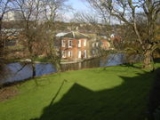
From here it flows eastward through Porter Clough through Mayfield Valley to the first of the remaining mill dams. Beyond Forge Dam the brook makes its way through Endcliffe Park
to Hunter's Bar
, before running between Ecclesall Road
and Sheffield General Cemetery
, past the former Wards brewery. The final section of the river from Pear Street, location of Sharrow Forge (No. 15), is now built over running through culverts beneath the intersection of London Road and the Inner Ring Road. It meets the similarly subterranean River Sheaf
beneath Sheffield Midland Station
.
. Lying at the edge of these hills, mill-owners found Millstone Grit
was an easily extractable resource. By 1740 Sheffield became the most extensive user of water-power in Britain and probably in Europe. Ninety mills had been built, two-thirds of them for grinding. By 1850 these mills numbered well over 100. In the Porter valley alone 21 mill dams served 19 water-wheels, mostly used for grinding corn, operating forge-hammers, and rolling mills, grinding knives and the various types of blade that made Sheffield famous. Most were active during the 18th and 19th centuries.
A mill is known to have existed at Fulwood in 1641, when Ulysses Fox its builder appeared before the Court of Kings Bench changed with "trespass", as the rights to grind corn were owned by the manor. Despite having to pay £35 8s 9d (£35.43) the mill survived. Later, there were two wheels served by two dams lying between Mill Lane and Mark Lane in Mayfield Valley above Forge Dam
. In 1760 the mill was used by Thomas Boulsover
for the production of Sheffield-plate buttons. A steam engine was used at the Nether or lower mill from 1847, and both were unused by 1884. The complex was given to Sheffield Corporation in 1937, but most of it has since been demolished. Unlike most installations in Sheffield, the dam impounded the whole of the flow from the Mayfield Brook, with the result that the dam (the normal local term for the lake, rather than the structure that creates the lake) has completely silted up.
Thomas Boulsover first used this site for the production of writing paper, but this was unsuccessful, as the water contained ochre. By 1765, it had become a forge and rolling mill, and by 1832 was used for the production of saws, while two drop-hammers were used to beat heated metal ingots into wrought-iron. Two water wheels were supplemented by a steam engine in 1835, and the operation ceased around 1887. A showman called Herbert Maxfield used the dam as a boating pool between 1900 and 1920, and the site was bought by Sheffield Corporation in 1939. The workers’ cottages became a café. The 40 feet (12.2 m) weir is still in good condition, but the dam has suffered from silting, as its layout was similar to the Fulwood dam.
The mill produced thin steel plate suitable for sawplate and for other items fashioned from strip steel, and wire used mainly in the cutlery industry. Wiremill Dam was once the site of the largest diameter water-wheel in Sheffield. Two overshot wheels were recorded in 1829, each 34.5 feet (10.5 m) in diameter and 4.25 feet (1.3 m) wide. They rotated at 6 rpm and were fed by a head of water of about 10 feet (3 m).
Named after Edward Shepherd, tenant at the wheel from 1749 to 1794, when 10 men were employed here. From the 1820s, the wheel was occupied by the Hinde family who worked here for over a hundred years and is now run as a museum by the Sheffield Industrial Museums Trust
.
During the early 1900s this dam became Porter Glen Boating Lake.
The dam became Endcliffe Boating Lake when Endcliffe Park was re-opened in 1887 to commemorate the Jubilee of Queen Victoria
following major re-design and landscaping by landscape architect William Goldring
. Porter Valley Parks are all part of the Sheffield Round Walk.
For a short while this dam at Hunter's Bar became Endcliffe Bathing Pool. It was closed at the outbreak of World War II
. Some 20 years later it was drained and filled in.
Both Lescar Wheel and Porter Works Dams were drained to provide housing between Ecclesall Road and Sharrow
Vale Road.
From here the brook follows Toad Walk (t'owd walk: Sheffield dialect) running beneath the high wall stone wall of Harland House, Wilson's Top mill and beneath the Egyptian-style gatehouse of Sheffield General Cemetery
.
Lying between Ecclesall Road
and the high wall stone wall of Sheffield General Cemetery
.
Drained and filled in, c. 1870. The land was developed to build houses in Napier Street and St Matthias Primary School.
Also drained and filled in, c. 1870.
The original grinding wheel (1810–1851) closed and the dam was leased to the Vulcan Works a forge, and rolling-mill providing water for boilers.
The White Lead Works was erected in 1759 producing pigments for paint and pottery glazes and continued in use until the later 19th century. When it closed, the dam was filled in and the site used to constructed a tram-depot c1910.
The Peak Park Anniversary Cycle Route follows the Porter Brook from Bingham Park to Porter Clough near Ringinglow.
River
A river is a natural watercourse, usually freshwater, flowing towards an ocean, a lake, a sea, or another river. In a few cases, a river simply flows into the ground or dries up completely before reaching another body of water. Small rivers may also be called by several other names, including...
in the City of Sheffield
Sheffield
Sheffield is a city and metropolitan borough of South Yorkshire, England. Its name derives from the River Sheaf, which runs through the city. Historically a part of the West Riding of Yorkshire, and with some of its southern suburbs annexed from Derbyshire, the city has grown from its largely...
, England
England
England is a country that is part of the United Kingdom. It shares land borders with Scotland to the north and Wales to the west; the Irish Sea is to the north west, the Celtic Sea to the south west, with the North Sea to the east and the English Channel to the south separating it from continental...
descending over 300 metres (1,000 feet) from its source among the sedge grass on Burbage moor behind a small farm on Hangram just inside the Peak District National Park
Peak District
The Peak District is an upland area in central and northern England, lying mainly in northern Derbyshire, but also covering parts of Cheshire, Greater Manchester, Staffordshire, and South and West Yorkshire....
in the west of the city at Clough Hollow, near the village of Ringinglow
Ringinglow
Ringinglow is a village in the western section of Sheffield, England. It is on the western border of Ecclesall Ward, and although it is within the boundary of Sheffield, it is self-contained, being entirely surrounded by open countryside....
. Porter Brook derives its name from its brownish colour, similar to the colour of Porter
Porter (beer)
Porter is a dark-coloured style of beer. The history and development of stout and porter are intertwined. The name was first used in the 18th century from its popularity with the street and river porters of London. It is generally brewed with dark malts...
, a brownish discolouration obtained as it passes over iron-ore deposits on its course from the source.
From here it flows eastward through Porter Clough through Mayfield Valley to the first of the remaining mill dams. Beyond Forge Dam the brook makes its way through Endcliffe Park
William Goldring (landscape architect)
William Goldring was a landscape architect. Goldring arrived in Royal Botanic Gardens, Kew where he was in charge of the Herbaceous Department at the world-famous botanical garden. He served as the Assistant Editor of The Garden , and the Editor of Woods and Forests...
to Hunter's Bar
Hunter's Bar
Hunter's Bar is a roundabout and former toll bar on Ecclesall Road in south-west Sheffield and was active until the late 19th century. The name also attaches to the area surrounding Hunter's Bar roundabout at the intersection of Ecclesall Road, Brocco Bank, Sharrow Vale Road and Junction Road. The...
, before running between Ecclesall Road
Ecclesall Road
|thumb|200px|right|Ecclesall Road South, which runs through a large part of the Hallam Constituency, the second wealthiest in the UK.Ecclesall Road is a road in Sheffield that runs for about 3.5 miles south-west from Sheffield's city centre under the number A625...
and Sheffield General Cemetery
Sheffield General Cemetery
The General Cemetery is a cemetery in the City of Sheffield, England that opened in 1836, and closed for burial in 1978. It was the principal cemetery in Victorian Sheffield with over 87,000 burials. Today it is a conservation area , and it is listed on the English Heritage National Register of...
, past the former Wards brewery. The final section of the river from Pear Street, location of Sharrow Forge (No. 15), is now built over running through culverts beneath the intersection of London Road and the Inner Ring Road. It meets the similarly subterranean River Sheaf
River Sheaf
The River Sheaf is a river in Sheffield, South Yorkshire, England. Its source is the union of the Totley Brook and the Old Hay Brook in Totley, now a suburb of Sheffield. It flows northwards, past Dore, through the valley called Abbeydale and north of Heeley...
beneath Sheffield Midland Station
Sheffield Midland station
Sheffield station, formerly Pond Street and later Sheffield Midland, is a railway station in Sheffield, England and is the busiest station in South Yorkshire...
.
Water power
The Porter, like the other rivers in Sheffield, is ideally suited for providing water power, as the final section falls some 450 feet (137.2 m) in a little over 4 miles (6.4 km). This enabled dams to be constructed reasonably close together, without the outflow from one mill being restricted by the next downstream dam. In addition to this water-power, natural sandstone was available in abundance in the nearby hills of Sheffield and the Peak District National ParkPeak District
The Peak District is an upland area in central and northern England, lying mainly in northern Derbyshire, but also covering parts of Cheshire, Greater Manchester, Staffordshire, and South and West Yorkshire....
. Lying at the edge of these hills, mill-owners found Millstone Grit
Gritstone
Gritstone or Grit is a hard, coarse-grained, siliceous sandstone. This term is especially applied to such sandstones that are quarried for building material. British gritstone was used for millstones to mill flour, to grind wood into pulp for paper and for grindstones to sharpen blades. "Grit" is...
was an easily extractable resource. By 1740 Sheffield became the most extensive user of water-power in Britain and probably in Europe. Ninety mills had been built, two-thirds of them for grinding. By 1850 these mills numbered well over 100. In the Porter valley alone 21 mill dams served 19 water-wheels, mostly used for grinding corn, operating forge-hammers, and rolling mills, grinding knives and the various types of blade that made Sheffield famous. Most were active during the 18th and 19th centuries.
- Fulwood Cornmill
A mill is known to have existed at Fulwood in 1641, when Ulysses Fox its builder appeared before the Court of Kings Bench changed with "trespass", as the rights to grind corn were owned by the manor. Despite having to pay £35 8s 9d (£35.43) the mill survived. Later, there were two wheels served by two dams lying between Mill Lane and Mark Lane in Mayfield Valley above Forge Dam
Forge Dam Park
Forge Dam Park is a park in Fulwood, in the city of Sheffield, South Yorkshire, England. It has a playground, thriving cafe and woods....
. In 1760 the mill was used by Thomas Boulsover
Thomas Boulsover
Thomas Boulsover , Sheffield cutler and the inventor of Sheffield Plate, was born in what is now the Ecclesfield district of the city and died at his home at Whiteley Wood Hall, on the River Porter....
for the production of Sheffield-plate buttons. A steam engine was used at the Nether or lower mill from 1847, and both were unused by 1884. The complex was given to Sheffield Corporation in 1937, but most of it has since been demolished. Unlike most installations in Sheffield, the dam impounded the whole of the flow from the Mayfield Brook, with the result that the dam (the normal local term for the lake, rather than the structure that creates the lake) has completely silted up.
- Forge DamForge Dam ParkForge Dam Park is a park in Fulwood, in the city of Sheffield, South Yorkshire, England. It has a playground, thriving cafe and woods....
(extant).
Thomas Boulsover first used this site for the production of writing paper, but this was unsuccessful, as the water contained ochre. By 1765, it had become a forge and rolling mill, and by 1832 was used for the production of saws, while two drop-hammers were used to beat heated metal ingots into wrought-iron. Two water wheels were supplemented by a steam engine in 1835, and the operation ceased around 1887. A showman called Herbert Maxfield used the dam as a boating pool between 1900 and 1920, and the site was bought by Sheffield Corporation in 1939. The workers’ cottages became a café. The 40 feet (12.2 m) weir is still in good condition, but the dam has suffered from silting, as its layout was similar to the Fulwood dam.
- Wiremill Dam (extant) Previously Whiteley Wood Rolling Mill, also known as Bowser Bottom or Thomas BoulsoverThomas BoulsoverThomas Boulsover , Sheffield cutler and the inventor of Sheffield Plate, was born in what is now the Ecclesfield district of the city and died at his home at Whiteley Wood Hall, on the River Porter....
's Rolling Mill.
The mill produced thin steel plate suitable for sawplate and for other items fashioned from strip steel, and wire used mainly in the cutlery industry. Wiremill Dam was once the site of the largest diameter water-wheel in Sheffield. Two overshot wheels were recorded in 1829, each 34.5 feet (10.5 m) in diameter and 4.25 feet (1.3 m) wide. They rotated at 6 rpm and were fed by a head of water of about 10 feet (3 m).
- Nether Wheel
- Shepherd's WheelShepherd WheelShepherd Wheel is a working museum in a former water-powered grinding workshop situated on the Porter Brook in the south-west of the City of Sheffield, England. One of the earliest wheels on the River Porter, it is one of the few remaining—and effectively complete—examples of this kind of...
(extant)
Named after Edward Shepherd, tenant at the wheel from 1749 to 1794, when 10 men were employed here. From the 1820s, the wheel was occupied by the Hinde family who worked here for over a hundred years and is now run as a museum by the Sheffield Industrial Museums Trust
Sheffield Industrial Museums Trust
The Sheffield Industrial Museums Trust is an independent charitable trust based in Sheffield, England, that runs the Sheffield City Council-owned Kelham Island, Abbeydale Industrial Hamlet, and Shepherd Wheel museums....
.
- Ibbotson’s Wheel (extant) previously Upper Spurgear Wheel or 4th Endcliffe Wheel.
During the early 1900s this dam became Porter Glen Boating Lake.
- Nether Spurgear Wheel (extant) also known as 3rd Endcliffe Wheel
- Second Endcliffe Wheel
- Holme Wheel (extant) also known as Nether Mill, Leather Wheel, or Whiteley Woods Bottoms Wheel (1754).
The dam became Endcliffe Boating Lake when Endcliffe Park was re-opened in 1887 to commemorate the Jubilee of Queen Victoria
Victoria of the United Kingdom
Victoria was the monarch of the United Kingdom of Great Britain and Ireland from 20 June 1837 until her death. From 1 May 1876, she used the additional title of Empress of India....
following major re-design and landscaping by landscape architect William Goldring
William Goldring (landscape architect)
William Goldring was a landscape architect. Goldring arrived in Royal Botanic Gardens, Kew where he was in charge of the Herbaceous Department at the world-famous botanical garden. He served as the Assistant Editor of The Garden , and the Editor of Woods and Forests...
. Porter Valley Parks are all part of the Sheffield Round Walk.
- First Endcliffe Wheel
For a short while this dam at Hunter's Bar became Endcliffe Bathing Pool. It was closed at the outbreak of World War II
World War II
World War II, or the Second World War , was a global conflict lasting from 1939 to 1945, involving most of the world's nations—including all of the great powers—eventually forming two opposing military alliances: the Allies and the Axis...
. Some 20 years later it was drained and filled in.
- Lescar Wheel Dam (Possible mis-spelling of Lascar, probably a trade mark?)
- Porter Works Dam
Both Lescar Wheel and Porter Works Dams were drained to provide housing between Ecclesall Road and Sharrow
Sharrow
For the village in North Yorkshire, see Sharow. For the shared lane roadway marking, see Shared lane marking.Sharrow is a district of Sheffield directly south west of Sheffield city centre....
Vale Road.
- Wilsons of Sharrow (extant) also known as Wilson's Bottom mill.
From here the brook follows Toad Walk (t'owd walk: Sheffield dialect) running beneath the high wall stone wall of Harland House, Wilson's Top mill and beneath the Egyptian-style gatehouse of Sheffield General Cemetery
Sheffield General Cemetery
The General Cemetery is a cemetery in the City of Sheffield, England that opened in 1836, and closed for burial in 1978. It was the principal cemetery in Victorian Sheffield with over 87,000 burials. Today it is a conservation area , and it is listed on the English Heritage National Register of...
.
- Stalker Wheel also known as Three-Square Dams
Lying between Ecclesall Road
Ecclesall Road
|thumb|200px|right|Ecclesall Road South, which runs through a large part of the Hallam Constituency, the second wealthiest in the UK.Ecclesall Road is a road in Sheffield that runs for about 3.5 miles south-west from Sheffield's city centre under the number A625...
and the high wall stone wall of Sheffield General Cemetery
Sheffield General Cemetery
The General Cemetery is a cemetery in the City of Sheffield, England that opened in 1836, and closed for burial in 1978. It was the principal cemetery in Victorian Sheffield with over 87,000 burials. Today it is a conservation area , and it is listed on the English Heritage National Register of...
.
- SharrowSharrowFor the village in North Yorkshire, see Sharow. For the shared lane roadway marking, see Shared lane marking.Sharrow is a district of Sheffield directly south west of Sheffield city centre....
Forge
Drained and filled in, c. 1870. The land was developed to build houses in Napier Street and St Matthias Primary School.
- Broomhall Cornmill
Also drained and filled in, c. 1870.
- Bennett's Wheel also known as Little Sheffield Moor or Vulcan Works Dam
The original grinding wheel (1810–1851) closed and the dam was leased to the Vulcan Works a forge, and rolling-mill providing water for boilers.
- Leadmill Dam also known as Marriott's Wheel (1732–1780s).
The White Lead Works was erected in 1759 producing pigments for paint and pottery glazes and continued in use until the later 19th century. When it closed, the dam was filled in and the site used to constructed a tram-depot c1910.
- Ponds Lane Dam
The Peak Park Anniversary Cycle Route follows the Porter Brook from Bingham Park to Porter Clough near Ringinglow.