
River Mun
Encyclopedia
| River Mun | |
|---|---|
| Geography | |
| Origin: | Northrepps, Norfolk |
| Grid reference: | |
| Terminates: | In to the North Sea at Mundesley, Norfolk |
| Grid reference: | |
| Length: | Unknown |
| fall: | Unknown |
| Catchment Area: | Unknown |
| Tributaries: | Unknown |
| Water Mills: | Two Watermills, Gimingham and Mundesley |
.jpg)
Norfolk
Norfolk is a low-lying county in the East of England. It has borders with Lincolnshire to the west, Cambridgeshire to the west and southwest and Suffolk to the south. Its northern and eastern boundaries are the North Sea coast and to the north-west the county is bordered by The Wash. The county...
, England
England
England is a country that is part of the United Kingdom. It shares land borders with Scotland to the north and Wales to the west; the Irish Sea is to the north west, the Celtic Sea to the south west, with the North Sea to the east and the English Channel to the south separating it from continental...
. The source of the river can be found in the Parish of Northrepps. The river finally runs into the North Sea
North Sea
In the southwest, beyond the Straits of Dover, the North Sea becomes the English Channel connecting to the Atlantic Ocean. In the east, it connects to the Baltic Sea via the Skagerrak and Kattegat, narrow straits that separate Denmark from Norway and Sweden respectively...
in the village of Mundesley
Mundesley
Mundesley is a coastal village and a civil parish in the English county of Norfolk. The village is 20.3 miles north-north east of Norwich, 7.3 miles south east of Cromer and 136 miles north east of London. The village lies 5.6 miles north-north east of the town of North Walsham. The nearest...
.
The source
The source of the River Mun can be found next to Craft Lane, close to Furyhill plantation between NorthreppsNorthrepps
Northrepps is a village and a civil parish in the English county of Norfolk. The village is southeast of Cromer, north of Norwich and north of London. The village lies west of the A149 which runs between Kings Lynn and Great Yarmouth. The nearest railway station is at Cromer for the Bittern...
and the hamlet of Frogshall
Frogshall
Frogshall is a small hamlet within the civil parish of Northrepps in the English county of Norfolk . The hamlet is southeast of Cromer, north of Norwich and north of London. Craft Lane runs through the hamlet between Northrepps and Southrepps. The nearest railway station is at Gunton on the...
. It runs in a south easterly direction through a wooded valley and passes under Craft Lane close to Frogshall Farm House. From here it runs through woodland for a short distance and into a large pool called Little Broad. From Little Broad, still in woodland, the river falls over a weir and into some marshy woodland known as Osier Carr. Deep in the heart of Osier Carr
Freshwater mussels
Freshwater pearl mussel
The freshwater pearl mussel, scientific name Margaritifera margaritifera, is an endangered species of freshwater mussel, an aquatic bivalve mollusc in the family Margaritiferidae....
(Bivalvia: Unionidae) can be found. The mussels are filter feeders, removing phytoplankton and other suspended particulate matter from the river. This removal of suspended matter from the water is often considered ecologically desirable, as it reduces phytoplankton blooms and in the treatment of drinking water. The river now passes under another lane from Sidestrand
Sidestrand
Sidestrand is a village and a civil parish in the English county of Norfolk. The village is North of Norwich, South East of Cromer and north-east of London.The nearest railway station is at North Walsham for the Bittern Line which runs between Cromer and Norwich...
. From here the river feeds a system of ponds and sluices in an area known as the Grove. Many drains feed into the river here. The river now turns almost south and passes under another lane called Cromer
Cromer
Cromer is a coastal town and civil parish in north Norfolk, England. The local government authority is North Norfolk District Council, whose headquarters is in Holt Road in the town. The town is situated 23 miles north of the county town, Norwich, and is 4 miles east of Sheringham...
Road and crosses countryside towards Ash Tree Farm and Ash Plantation
Plantation
A plantation is a long artificially established forest, farm or estate, where crops are grown for sale, often in distant markets rather than for local on-site consumption...
. The river now widens slightly and begins to cross open countryside, slowly turning south east again. Along this section the Mun runs adjacent to several small reservoirs and ponds and drains.
Gimingham watermill
.jpg)
Gimingham
Gimingham is a village and civil parish in the English county of Norfolk. The village is north of North Walsham and east of Cromer. It is north of the city of Norwich. Nearby road communications with Gimingham are the A140 to Norwich, the A148 and A149 to King's Lynn, and the A149 into the...
the river flows into a series of Mill Ponds. These ponds fed Gimingham watermill (Nat Grid Ref TG28663690) which is the first of two mills that stood on the river. The Mill dam once held back a 20 acres (80,937.2 m²) broad fed by the River. The water ran under the Mill street to reach the waterwheel, which was probably originally overshot.
There has been a mill at this point since the time of the Domesday book
Domesday Book
Domesday Book , now held at The National Archives, Kew, Richmond upon Thames in South West London, is the record of the great survey of much of England and parts of Wales completed in 1086...
. The last mill to work here was built of local brick and flint brought in from local beaches. The original waterwheel went fairly early on, first being supplemented by steam and then replaced by a turbine
Turbine
A turbine is a rotary engine that extracts energy from a fluid flow and converts it into useful work.The simplest turbines have one moving part, a rotor assembly, which is a shaft or drum with blades attached. Moving fluid acts on the blades, or the blades react to the flow, so that they move and...
with half twist drive in 1912 and then later by diesel engine
Diesel engine
A diesel engine is an internal combustion engine that uses the heat of compression to initiate ignition to burn the fuel, which is injected into the combustion chamber...
s, although water was still used for cooling them. The mill carried on working until 30 November 1976, using its diesel power to mill animal feedstuffs. The watermill was worked in conjunction with the nearby Gimingham postmill until 1877. The original heavy diesel oil engine has been carefully preserved and stands on Mill Street just below the old mill. Gimingham Mill Lake is a very popular fishing location. In the lake, pit and river, Bream, Carp
Carp
Carp are various species of oily freshwater fish of the family Cyprinidae, a very large group of fish native to Europe and Asia. The cypriniformes are traditionally grouped with the Characiformes, Siluriformes and Gymnotiformes to create the superorder Ostariophysi, since these groups have certain...
, Tench
Tench
The tench or doctor fish is a freshwater and brackish water fish of the cyprinid family found throughout Eurasia from Western Europe including the British Isles east into Asia as far as the Ob and Yenisei Rivers. It is also found in Lake Baikal...
and Roach can be caught.
From Gimingham the river cross more open farm land now heading east, passing on its left Mundesley
Mundesley
Mundesley is a coastal village and a civil parish in the English county of Norfolk. The village is 20.3 miles north-north east of Norwich, 7.3 miles south east of Cromer and 136 miles north east of London. The village lies 5.6 miles north-north east of the town of North Walsham. The nearest...
Hospital which was refurbished in 1997 and is now the Diana Princess of Wales Treatment Centre for Drug
Drug
A drug, broadly speaking, is any substance that, when absorbed into the body of a living organism, alters normal bodily function. There is no single, precise definition, as there are different meanings in drug control law, government regulations, medicine, and colloquial usage.In pharmacology, a...
and Alcohol
Alcohol
In chemistry, an alcohol is an organic compound in which the hydroxy functional group is bound to a carbon atom. In particular, this carbon center should be saturated, having single bonds to three other atoms....
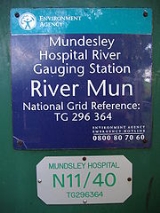
Problems. Where the road leading up to the hospital crosses the River Mun, the Environment Agency has a Water Resource Management gauging station. From here the river begins to skirt the southern side of the coastal village of Mundesley
Mundesley
Mundesley is a coastal village and a civil parish in the English county of Norfolk. The village is 20.3 miles north-north east of Norwich, 7.3 miles south east of Cromer and 136 miles north east of London. The village lies 5.6 miles north-north east of the town of North Walsham. The nearest...
.
Mun valley and Mundesley golf course
.jpg)
.jpg)
Harry Vardon
Harry Vardon was a Jersey professional golfer and member of the fabled Great Triumvirate of the sport in his day, along with John Henry Taylor and James Braid. He won The Open Championship a record six times and also won the U.S. Open.-Biography:Vardon was born in Grouville, Jersey, Channel Islands...
(1870–1937), built on the rolling hillside of the River Mun valley. Today its nine holes, with 18 tees, offer a satisfying challenge to players of all abilities. Harry Vardon’s association with Mundesley Golf Club spanned many years, from consultation, in 1900 to his misfortune to contract tuberculosis
Tuberculosis
Tuberculosis, MTB, or TB is a common, and in many cases lethal, infectious disease caused by various strains of mycobacteria, usually Mycobacterium tuberculosis. Tuberculosis usually attacks the lungs but can also affect other parts of the body...
in 1903, and it was to Mundesley’s sanatorium
Sanatorium
A sanatorium is a medical facility for long-term illness, most typically associated with treatment of tuberculosis before antibiotics...
that he went for treatment. While recuperating in 1904, still at the sanatorium, he ventured along the lane which bisects the course to enjoy a round of golf. Here he experienced his only career hole-in-one, on what is now the sixth, a feat which no doubt contributed to the success of his convalescence.
From the golf
Golf
Golf is a precision club and ball sport, in which competing players use many types of clubs to hit balls into a series of holes on a golf course using the fewest number of strokes....
course the river travels a short distance due east and enters the village under Trunch
Trunch
Trunch is a village and parish in Norfolk, England, situated three miles north of North Walsham and two miles from the coast at Mundesley. At the Census 2001 the village had a population of 805, and 388 households. The parish covers an area of ....
Road close to its junction with High Street and Heath Road. Just past Trunch Road the river falls over another weir
Weir
A weir is a small overflow dam used to alter the flow characteristics of a river or stream. In most cases weirs take the form of a barrier across the river that causes water to pool behind the structure , but allows water to flow over the top...
before turning north into the eastern side of the village.
Mundesley Watermill
.jpg)
Dam
A dam is a barrier that impounds water or underground streams. Dams generally serve the primary purpose of retaining water, while other structures such as floodgates or levees are used to manage or prevent water flow into specific land regions. Hydropower and pumped-storage hydroelectricity are...
the river to form the mill pond we see today which is some considerable height above the road. When the mill was working, 8 million gallons of water flowed through per day. When the mill was worked by the Larter family in the 1920s, the deeds stated that anyone interfering with the river had to pay dues to the millers. The Larter family also used the mill to generate electricity, which also supplied power to some of the surrounding properties including a Bell's grocery shop, Larter & Rudran's bicycle garage and a property at The Dell. The mill burnt down in November 1956. Some of the cog wheels were still visible in their mountings within the shell of the building in 1959. The remains of the building were finally pulled down in the summer of 1965. The waterwheel was large with a diameter of 26 feet (7.9 m) and the owner of the Mill House decided to enclose the wheel behind a grill and to leave it as a showpiece. The wooden spokes and the rim can still be seen, and some of the metal scoops and some wooden cogs have been replaced. For many years it still turned whenever enough water was available. The river's water flowed over the wheel and then under the road and into the North sea through a pipe.
See also
- There is also a Mun RiverMun RiverThe Mun River , sometimes spelled Moon River, is a tributary of the Mekong river. It carries approximately 21,000 cubic kilometres of water per year.-Geography:...
(Thai: แม่น้ำมูล) in ThailandThailandThailand , officially the Kingdom of Thailand , formerly known as Siam , is a country located at the centre of the Indochina peninsula and Southeast Asia. It is bordered to the north by Burma and Laos, to the east by Laos and Cambodia, to the south by the Gulf of Thailand and Malaysia, and to the...
, sometimes spelled Moon River, it is a tributary
Tributary
A tributary or affluent is a stream or river that flows into a main stem river or a lake. A tributary does not flow directly into a sea or ocean...
of the Mekong river. It carries approximately 21,000 cubic kilometres of water per year.
- Cooking Freshwater Mussels at http://en.wikibooks.org/wiki/Cookbook:Mussel