
Rio de la Plata Earthquake 1888
Encyclopedia
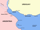
The 1888 Río de la Plata earthquake occurred on June 5, 1888, measuring 5.5 on the Richter scale, and shook the upper Río de la Plata
at 3:20 UTC-3
. The epicentre was located 15 kilometres (9 mi) southwest of Colonia del Sacramento
(Uruguay
) and 42 kilometres (26 mi) east of Buenos Aires
(Argentina
), with a hypocentre at a depth of 30 kilometres (19 mi).
journal La Tribuna Popular reported the earthquake and its effects: The houses' woodwork creaked loudly, lamps swung, furniture moved and paintings fell off walls. Glassware objects broke and porcelain could be seen jolting out of cupboards. Astonished at the strong earthquake, inhabitants have had a sleepless night...
Also, a Colonia del Sacramento local journal La Lucha reported on a particular event: The steamer 'Saturno' en route from the neighbouring country's capital (Buenos Aires) was calmly sailing in 20 feet (6 m) of water along the centre of the channel when she came to a sudden halt, as though she had run aground. The captain had soundings taken but the vessel, as if moved by some hidden force, was freed from the ground and continued on her way.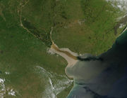
However, at no time since this earthquake have antiseismic building measures been taken in either of the two nations. This is particularly worrying since a major 42 km Buenos Aires-Colonia bridge is being planned for the near future.
It is worth mentioning, though, that there are no aseismic regions in the world. Such an event could therefore happen again in the River Plate as evidenced by the 26th June 1988 and 10 January 1990 earthquakes, the latter being the only one registered on Uruguayan mainland territory.
These earthquakes are believed to have originated in a particular region, the Punta del Este
basin, which is highly faulted and where tectonic plates might experience certain movement thus causing the earthquake waves, according to Alberto Benavídez Sosa MGEOPHYS, agronomical engineer and former president of CERESIS (Seismology Regional Centre for South America)
Earthquakes in the easternmost edge of the Pacific tectonic plates
can occasionally be felt in the Argentine Atlantic coast, including Buenos Aires and only rarely on the Uruguayan coast.
Río de la Plata
The Río de la Plata —sometimes rendered River Plate in British English and the Commonwealth, and occasionally rendered [La] Plata River in other English-speaking countries—is the river and estuary formed by the confluence of the Uruguay River and the Paraná River on the border between Argentina and...
at 3:20 UTC-3
UTC-3
UTC−03:00 is an identifier for a time offset from UTC of −03:00.-As standard time :*Suriname*Falkland Islands*French Guiana*Brazil - East Northern and Northeastern States...
. The epicentre was located 15 kilometres (9 mi) southwest of Colonia del Sacramento
Colonia del Sacramento
Colonia del Sacramento is a city in southwestern Uruguay, by the Río de la Plata, facing Buenos Aires, Argentina. It is the oldest town in Uruguay and capital of the departamento of Colonia. It has a population of around 22,000.It is renowned for its historic quarter, a World Heritage Site...
(Uruguay
Uruguay
Uruguay ,officially the Oriental Republic of Uruguay,sometimes the Eastern Republic of Uruguay; ) is a country in the southeastern part of South America. It is home to some 3.5 million people, of whom 1.8 million live in the capital Montevideo and its metropolitan area...
) and 42 kilometres (26 mi) east of Buenos Aires
Buenos Aires
Buenos Aires is the capital and largest city of Argentina, and the second-largest metropolitan area in South America, after São Paulo. It is located on the western shore of the estuary of the Río de la Plata, on the southeastern coast of the South American continent...
(Argentina
Argentina
Argentina , officially the Argentine Republic , is the second largest country in South America by land area, after Brazil. It is constituted as a federation of 23 provinces and an autonomous city, Buenos Aires...
), with a hypocentre at a depth of 30 kilometres (19 mi).
Newspaper articles
On June 5 1888 the MontevideoMontevideo
Montevideo is the largest city, the capital, and the chief port of Uruguay. The settlement was established in 1726 by Bruno Mauricio de Zabala, as a strategic move amidst a Spanish-Portuguese dispute over the platine region, and as a counter to the Portuguese colony at Colonia del Sacramento...
journal La Tribuna Popular reported the earthquake and its effects: The houses' woodwork creaked loudly, lamps swung, furniture moved and paintings fell off walls. Glassware objects broke and porcelain could be seen jolting out of cupboards. Astonished at the strong earthquake, inhabitants have had a sleepless night...
Also, a Colonia del Sacramento local journal La Lucha reported on a particular event: The steamer 'Saturno' en route from the neighbouring country's capital (Buenos Aires) was calmly sailing in 20 feet (6 m) of water along the centre of the channel when she came to a sudden halt, as though she had run aground. The captain had soundings taken but the vessel, as if moved by some hidden force, was freed from the ground and continued on her way.
Consequences
Every settlement along the Río de la Plata's shore was affected, especially the cities of Buenos Aires and Montevideo. Only slight damage occurred since there were no high buildings or underground trains in those cities at the time.However, at no time since this earthquake have antiseismic building measures been taken in either of the two nations. This is particularly worrying since a major 42 km Buenos Aires-Colonia bridge is being planned for the near future.
Background, precedents and provisions
The panic caused by this earthquake among the inhabitants of both banks of Río de la Plata was marked, because they were unfamiliar with seismic events, as are today’s inhabitants. However, a previous event had been recorded: the 15 August 1848 earthquake which, just as that of 1888, caused no major damage and may have been seen as an isolated phenomenon or since its epicentre was faraway from the continent and thus distant from settlements, it may have been considered that future quakes would probably occur in those latitudes and cause no damage on the continent.It is worth mentioning, though, that there are no aseismic regions in the world. Such an event could therefore happen again in the River Plate as evidenced by the 26th June 1988 and 10 January 1990 earthquakes, the latter being the only one registered on Uruguayan mainland territory.
These earthquakes are believed to have originated in a particular region, the Punta del Este
Punta del Este
Punta del Este is a resort town on the Atlantic Coast in the Maldonado Department of southeastern Uruguay. It is located on the intersection of Route 10 with Route 39, directly southeast of the department capital Maldonado and about east of Montevideo...
basin, which is highly faulted and where tectonic plates might experience certain movement thus causing the earthquake waves, according to Alberto Benavídez Sosa MGEOPHYS, agronomical engineer and former president of CERESIS (Seismology Regional Centre for South America)
Earthquakes in the easternmost edge of the Pacific tectonic plates
Tectonic Plates
Tectonic Plates is a 1992 independent Canadian film directed by Peter Mettler. Mettler also wrote the screenplay based on the play by Robert Lepage. The film stars Marie Gignac, Céline Bonnier and Robert Lepage.-Plot summary:...
can occasionally be felt in the Argentine Atlantic coast, including Buenos Aires and only rarely on the Uruguayan coast.
External links
- CERESIS (Seismology Regional Centre for South America) http://www.ceresis.org
- Assignment Report for the Buenos Aires-Colonia Bridge Project. http://www.puentep-laracolonia.com.ar/ingles/cooperacion/informe.html
- Benavídez Sosa, Alberto. Seismicity and Seismotectonics in Uruguay(Spanish) http://www.ucm.es/BUCM/revistas/fis/02144557/articulos/FITE9898110167A.PDF