

Rio Grande Trail
Encyclopedia
Rio Grande
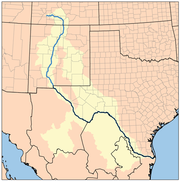
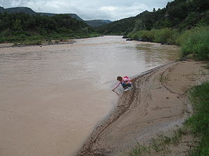
The Rio Grande is a river that flows from southwestern Colorado in the United States to the Gulf of Mexico. Along the way it forms part of the Mexico – United States border. Its length varies as its course changes...
in the U.S. state
U.S. state
A U.S. state is any one of the 50 federated states of the United States of America that share sovereignty with the federal government. Because of this shared sovereignty, an American is a citizen both of the federal entity and of his or her state of domicile. Four states use the official title of...
of New Mexico
New Mexico
New Mexico is a state located in the southwest and western regions of the United States. New Mexico is also usually considered one of the Mountain States. With a population density of 16 per square mile, New Mexico is the sixth-most sparsely inhabited U.S...
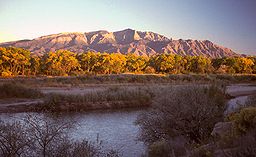
. The river extends over 1,800 total miles, some 700 miles (1,126.5 km) of which pass though the heart of New Mexico. It is the state's primary drainage feature and most valuable natural and cultural resource. The river and its bosque
Bosque
Bosque is the name for areas of gallery forest found along the riparian flood plains of stream and river banks in the southwestern United States...
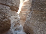
provide a wide variety of recreation, including hunting and fishing, birdwatching, river rafting, hiking, biking, and horseback riding. The river also flows through or beside numerous spectacular and geologically interesting landform
Landform
A landform or physical feature in the earth sciences and geology sub-fields, comprises a geomorphological unit, and is largely defined by its surface form and location in the landscape, as part of the terrain, and as such, is typically an element of topography...
s, the result of extensive volcanism
Volcanism
Volcanism is the phenomenon connected with volcanoes and volcanic activity. It includes all phenomena resulting from and causing magma within the crust or mantle of a planet to rise through the crust and form volcanic rocks on the surface....
and erosion
Erosion
Erosion is when materials are removed from the surface and changed into something else. It only works by hydraulic actions and transport of solids in the natural environment, and leads to the deposition of these materials elsewhere...
within the Rio Grande Rift
Rio Grande Rift
The Rio Grande Rift is a north-trending continental rift zone. It separates the Colorado Plateau in the west from the interior of the North American craton on the east. The rift extends from central Colorado in the north to the state of Chihuahua, Mexico in the south. The rift zone consists of four...
. Although some trail advocates would like to see the trail extended the full distance through New Mexico, from the Colorado
Colorado
Colorado is a U.S. state that encompasses much of the Rocky Mountains as well as the northeastern portion of the Colorado Plateau and the western edge of the Great Plains...
border to the United States–Mexico border
United States–Mexico border
The United States–Mexico border is the international border between the United States and Mexico. It runs from Imperial Beach, California, and Tijuana, Baja California, in the west to Matamoros, Tamaulipas, and Brownsville, Texas, in the east, and traverses a variety of terrains, ranging from major...
, the portion proposed for initial development extends 300 miles (482.8 km), from Bernalillo
Bernalillo, New Mexico
Bernalillo is a town in Sandoval County, New Mexico, in the United States. As of the 2000 census, the town population was 6,611. It is the county seat of Sandoval County.Bernalillo is part of the Albuquerque Metropolitan Statistical Area.-Geography:...
south to Las Cruces
Las Cruces, New Mexico
Las Cruces, also known as "The City of the Crosses", is the county seat of Doña Ana County, New Mexico, United States. The population was 97,618 in 2010 according to the 2010 Census, making it the second largest city in the state....
.
History
Governor Bill Richardson and New Mexico State Parks proposed the establishment of this trail. In 2006 the New Mexico Legislature provided funding to begin planning and development of the project.The core of the proposed trail is the existing Paseo del Bosque Trail in Albuquerque, a product of long-standing collaboration among numerous interest groups and agencies including the Middle Rio Grande Conservancy District (MRGCD). MRGCD also maintains ditchbank trails in Corrales
Corrales, New Mexico
Corrales is a village in Sandoval County, New Mexico, United States. The population was 8,329 at the 2010 Census. It is part of the Albuquerque Metropolitan Statistical Area. With proximity to the Rio Grande, the village was founded for agricultural purposes. The Rio Grande Bosque on the eastern...
and other communities in the area.
Proposed trail corridor
In many locations the basic infrastructure already exists in the form of either designated trails or informal trails. Informal trails exist on ditchbanks of local acequiaAcequia
An acequia or séquia is a community-operated waterway used in Spain and former Spanish colonies in the Americas for irrigation. Particularly in Spain, the Andes, northern Mexico, and the modern-day American Southwest, acequias are usually historically engineered canals that carry snow runoff or...
s and irrigation districts, on abandoned right-of-ways of old railroads, and on some publicly owned land. Most notable of these are the 16 miles (25.7 km) Paseo del Bosque Trail, and the abandoned right-of-way of the Chili Line
Chili Line
The Chili Line, officially known as the Santa Fe Branch, was a narrow gauge branch of the Denver and Rio Grande Western Railroad . It ran from Antonito, Colorado, to Santa Fe, New Mexico, United States...
of the Denver and Rio Grande Western Railroad
Denver and Rio Grande Western Railroad
The Denver & Rio Grande Western Railroad , often shortened to Rio Grande or D&RGW, formerly the Denver & Rio Grande Railroad, is a defunct U.S. railroad company. The railroad started as a narrow gauge line running south from Denver, Colorado in 1870; however, served mainly as a transcontinental...
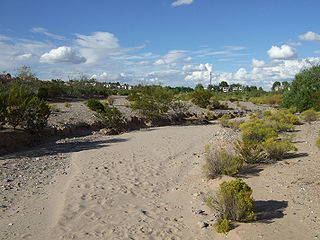
(San Luis Valley Route). Spur trails also exist, both designated trails and informal trails as above plus tributary arroyos
Arroyo (creek)
An arroyo , a Spanish word translated as brook, and also called a wash is usually a dry creek or stream bed—gulch that temporarily or seasonally fills and flows after sufficient rain. Wadi is a similar term in Africa. In Spain, a rambla has a similar meaning to arroyo.-Types and processes:Arroyos...
.
The Paseo del Bosque Trail is the nucleus of the proposed trail. The Mid-Region Council of Governments (MRCOG), the regional planning group for Albuquerque and its surrounds, decided to extend the trail north to Bernalillo and south to Belen, about 40 miles (64.4 km) in all. In 2005, New Mexico State Parks committed $3 million to MRCOG to develop this plan. In 2006, New Mexico State Parks determined its next priority to be the segment from Belen south to Las Cruces. This was determined in part due to the potential for synergy with established state parks and ongoing trail development projects. For planning purposes, the 300 miles (482.8 km) trail corridor from Bernalillo south to Las Cruces was divided into six sections: MRCOG Bosque, Sevilleta Corridor, BLM Socorro Bosque, Camino Real Corridor, Elephant Butte Corridor, and Southern State Parks Corridor. In 2007, under the federal Recreational Trails Program, New Mexico State Parks awarded $474,698 to Elephant Butte Lake State Park for a West Lakeshore Trail. Meanwhile, as community trail development activities grew north of Bernalillo, especially in and north of the Santa Fe area, NMSP awarded $80,000 to the Santa Fe National Forest
Santa Fe National Forest
The Santa Fe National Forest is a protected national forest in northern New Mexico in the Southwestern United States. It was established in 1915 and covers 1,567,181 acres . Elevations range from 5,300 feet to 13,103 feet at the summit of Truchas Peak, located within the Pecos Wilderness...
for a developed trailhead near Santa Fe on the Caja del Rio.
Pojoaque, New Mexico
Pojoaque is a census-designated place in Santa Fe County, New Mexico, United States. It is part of the Santa Fe, New Mexico Metropolitan Statistical Area. The population was 1,261 at the 2000 census. Pojoaque and Pojoaque Pueblo are neighboring communities...
and Los Alamos
Los Alamos, New Mexico
Los Alamos is a townsite and census-designated place in Los Alamos County, New Mexico, United States, built upon four mesas of the Pajarito Plateau and the adjoining White Rock Canyon. The population of the CDP was 12,019 at the 2010 Census. The townsite or "the hill" is one part of town while...
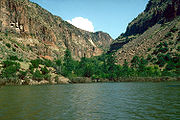
), the Rio Grande passes through several pueblo
Pueblo
Pueblo is a term used to describe modern communities of Native Americans in the Southwestern United States of America. The first Spanish explorers of the Southwest used this term to describe the communities housed in apartment-like structures built of stone, adobe mud, and other local material...
s and White Rock Canyon. This presents several kinds of obstacles to trail development. In particular, the lake behind Cochiti Dam
Cochiti Dam
The Cochiti Dam is an earthen fill dam located on the Rio Grande River in Sandoval County, New Mexico approximately 50 miles north of Albuquerque, New Mexico in the United States...
backs into White Rock Canyon.
List of features
Features of the proposed trail corridor are listed in order from north to south. Bridges across the Rio Grande (listed separately) are candidate locations for trailheads.
Rio Arriba County, New Mexico
-2010:Whereas according to the 2010 U.S. Census Bureau:*51.6% White*0.5% Black*16.0% Native American*0.4% Asian*0.0% Native Hawaiian or Pacific Islander*3.3% Two or more races*28.2% Other races*71.3% Hispanic or Latino -2000:...
- EarthshipEarthshipAn earthship is a type of passive solar house made of natural and recycled materials. Designed and marketed by Earthship Biotecture of Taos, New Mexico, the homes are primarily constructed to work as autonomous buildings and are generally made of earth-filled tires, using thermal mass...
s
- Rio Grande GorgeRio Grande GorgeThe Rio Grande Gorge runs from northwest to southeast of Taos, New Mexico, through the basalt flows of the Taos Plateau volcanic field. The gorge depth is 800 feet just south of the Gorge Bridge, which spans the gorge ten miles northwest of Taos....
- Orilla Verde Recreation Area
- Embudo StationEmbudo, New MexicoEmbudo is an unincorporated community in Rio Arriba County, New Mexico, United States. It is on NM State Road 68. The Embudo Station is located 2.9 miles south of the intersection of NM State Road 75, near where the Embudo River flows into the Rio Grande.The name "Embudo", meaning "funnel" in...
- Lyden, New Mexico
- Ohkay Owingeh (formerly San Juan PuebloSan Juan PuebloSan Juan Pueblo may refer to*old name of Ohkay Owingeh, New Mexico*San Juan Pueblo...
) - Española, New MexicoEspañola, New MexicoEspañola also known as Espanola , is a city primarily in Rio Arriba County, New Mexico, in the United States. A portion of the central and eastern section of the city is in Santa Fe County. Española was founded in 1880 as a railroad village, incorporated as a city in 1925. The city is situated in...
- Old Spanish Trail (trade route)Old Spanish Trail (trade route)The Old Spanish Trail is a historical trade route which connected the northern New Mexico settlements near or in Santa Fe, New Mexico with that of Los Angeles, California and southern California. Approximately long, it ran through areas of high mountains, arid deserts, and deep canyons. It is...
Santa Fe County, New Mexico
Santa Fe County, New Mexico
-2010:Whereas according to the 2010 U.S. Census Bureau:*76.2% White*0.9% Black*3.1% Native American*1.2% Asian*0.1% Native Hawaiian or Pacific Islander*3.6% Two or more races*14.9% Other races*50.6% Hispanic or Latino -2000:...
- Santa Clara Pueblo
- San Ildefonso Pueblo
- Pajarito PlateauPajarito PlateauThe Pajarito Plateau is a volcanic plateau in north central New Mexico, United States. The plateau, part of the Jemez Mountains, is bounded on the west by the Valles Caldera and on the east by the White Rock Canyon of the Rio Grande...
- White Rock Canyon
- Bandelier National MonumentBandelier National MonumentBandelier National Monument is a National Monument preserving the homes of the Ancestral Pueblo People. It is named after Swiss anthropologist Adolph Bandelier, who researched the cultures of the area. Bandelier was designated a National Monument on February 11, 1916, and most of its backcountry...
- Caja del Rio
Sandoval County, New Mexico
Sandoval County, New Mexico
-Indian reservations:Sandoval County has 12 Indian reservations and two joint-use areas lying within its borders, the second most of any county in the United States -Indian reservations:Sandoval County has 12 Indian reservations and two joint-use areas lying within its borders, the second most of...
- Santo Domingo Pueblo
- Kasha-Katuwe Tent Rocks National MonumentKasha-Katuwe Tent Rocks National MonumentKasha-Katuwe Tent Rocks National Monument, located 40 miles southwest of Santa Fe, New Mexico , is a Bureau of Land Management managed site that was established as a U.S...
- Cochiti LakeCochiti DamThe Cochiti Dam is an earthen fill dam located on the Rio Grande River in Sandoval County, New Mexico approximately 50 miles north of Albuquerque, New Mexico in the United States...
- Cochiti Pueblo
Bernalillo County, New Mexico
Bernalillo County, New Mexico
-2010:Whereas according to the 2010 U.S. Census Bureau:*69.4% White*3.0% Black*4.8% Native American*2.3% Asian*0.1% Native Hawaiian or Pacific Islander*4.4% Two or more races*16.0% Other races*47.9% Hispanic or Latino -2000:...
- San Felipe PuebloSan Felipe Pueblo, New MexicoSan Felipe Pueblo is a census-designated place in Sandoval County, New Mexico, United States and is located 10 miles north of Bernalillo. As of the 2000 census, the CDP population was 2,080. It is part of the Albuquerque Metropolitan Statistical Area...
- BernalilloBernalillo, New MexicoBernalillo is a town in Sandoval County, New Mexico, in the United States. As of the 2000 census, the town population was 6,611. It is the county seat of Sandoval County.Bernalillo is part of the Albuquerque Metropolitan Statistical Area.-Geography:...
- Rio Rancho Bosque
- Paseo del Bosque Trail
- AlbuquerqueAlbuquerque, New MexicoAlbuquerque is the largest city in the state of New Mexico, United States. It is the county seat of Bernalillo County and is situated in the central part of the state, straddling the Rio Grande. The city population was 545,852 as of the 2010 Census and ranks as the 32nd-largest city in the U.S. As...
- Isleta PuebloIsleta PuebloIsleta Pueblo is an unincorporated Tanoan pueblo in Bernalillo County, New Mexico, United States, originally established around the 14th century.-Overview:...
- Los LunasLos Lunas, New Mexico-2010:Whereas according to the 2010 U.S. Census Bureau:*72.1% White*2.0% Black*2.5% Native American*0.8% Asian*0.1% Native Hawaiian or Pacific Islander*4.2% Two or more races*18.3% Other races*57.9% Hispanic or Latino -2000:...
- BelenBelen, New MexicoBelen is a city in Valencia County, New Mexico, United States. Belen is Spanish for Bethlehem, and over time has gained the nickname "Hub City" because of the Belen Cutoff of the Atchison, Topeka and Santa Fe Railway. The Cutoff made it possible for many more trains to travel east and west across...
- Bosque
- Bernardo
- Escondida
Socorro County
Socorro County, New Mexico
-2010:Whereas according to the 2010 U.S. Census Bureau:*75.1% White*1.1% Black*11.7% Native American*1.2% Asian*0.0% Native Hawaiian or Pacific Islander*2.8% Two or more races*8.1% Other races*48.5% Hispanic or Latino -2000:...
- Sevilleta National Wildlife RefugeSevilleta National Wildlife RefugeThe Sevilleta National Wildlife Refuge is a protected area of New Mexico managed by the United States Fish and Wildlife Service as part of the National Wildlife Refuge System. It is located in the Chihuahuan desert 20 miles north of Socorro, New Mexico...
- San Lorenzo Canyon Recreation Area
- San AntonioSan Antonio, New MexicoSan Antonio is an unincorporated community in Socorro County, New Mexico, United States, roughly in the center of the state. The entire population of the county is around 18,000; the population of San Antonio is hard to pin down because the area is somewhat ill-defined.San Antonio is nowadays...
- Bosque del Apache National Wildlife RefugeBosque del Apache National Wildlife RefugeThe Bosque del Apache National Wildlife Refuge , in southern Socorro County, New Mexico, is administered by the U.S. Fish and Wildlife Service. It sits near the Rio Grande astride New Mexico Route 1, formerly U.S. Highway 85. The refuge was founded in 1939....
- SocorroSocorro, New MexicoSocorro is a city in Socorro County in the U.S. state of New Mexico. It stands in the Rio Grande Valley at an elevation of . The population was 9,051 at the 2010 census...
- Trinity (nuclear test)
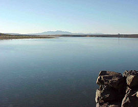
- Elephant Butte Lake
- Truth or ConsequencesTruth or Consequences, New MexicoTruth or Consequences is a spa city and the county seat of Sierra County, New Mexico, United States. As of the 2000 census, the population was 7,289. It is commonly known within New Mexico as T or C....
- Caballo LakeCaballo LakeCaballo Lake is a reservoir on the Rio Grande River in southern New Mexico, United States. It is the fourth largest reservoir in New Mexico in terms of surface area and the fifth largest body of water in New Mexico in terms of volume...
Sierra County
Sierra County, New Mexico
-2010:Whereas according to the 2010 U.S. Census Bureau:*85.6% White*0.4% Black*1.7% Native American*0.4% Asian*0.0% Native Hawaiian or Pacific Islander*3.3% Two or more races*8.6% Other races*28.0% Hispanic or Latino -2000:...
- Derry and ArreyArrey, New MexicoArrey is an unincorporated town in Sierra County, New Mexico, United States. It lies about 22 miles south of Truth or Consequences....
- SalemSalem, New MexicoSalem is a census-designated place in Doña Ana County, New Mexico, United States. The population was 795 at the 2000 census. It is part of the Las Cruces Metropolitan Statistical Area.-Geography:Salem is located at ....
- HatchHatch, New MexicoHatch is a village in Doña Ana County, New Mexico, United States. The population was 1,673 at the 2000 census. It is part of the Las Cruces Metropolitan Statistical Area. The town is experiencing moderate growth, along with its outliers of Salem, Arrey, Derry, and Rincon...
- RinconRincon, New MexicoRincon is a census-designated place in Doña Ana County, New Mexico, in the United States. As of the 2000 census, the CDP population was 220...
Doña Ana County
Doña Ana County, New Mexico
-2010:Whereas according to the 2010 U.S. Census Bureau:*74.1% White*1.7% Black*1.5% Native American*1.1% Asian*0.1% Native Hawaiian or Pacific Islander*3.0% Two or more races*18.5% Other races*65.7% Hispanic or Latino -2000:...
- Radium Springs, New MexicoRadium Springs, New MexicoRadium Springs is a census-designated place in Doña Ana County, New Mexico, United States. The population was 1,518 at the 2000 census. It is part of the Las Cruces Metropolitan Statistical Area.-Geography:...
- Fort SeldenFort SeldenFort Selden was a United States Army post, occupying the area in what is now Radium Springs, New Mexico. Established in 1865 for the purpose of protecting westward settlers from Native American raids, the post fell into disrepair after the American Civil War...
- Jornada del MuertoJornada del MuertoThe Jornada del Muerto in the U.S. state of New Mexico was the name given by the Spanish conquistadors to the Jornada del Muerto Desert basin, and the particularly dry stretch of a route through it.The trail lead northward from central Spanish colonial New Spain, present-day Mexico, to the farthest...
- Doña Ana, New MexicoDoña Ana, New MexicoDoña Ana is a census-designated place in Doña Ana County, New Mexico, in the United States. The population was 1,379 at the 2000 census. It is part of the Las Cruces Metropolitan Statistical Area.-Geography:...
- Las Cruces, New MexicoLas Cruces, New MexicoLas Cruces, also known as "The City of the Crosses", is the county seat of Doña Ana County, New Mexico, United States. The population was 97,618 in 2010 according to the 2010 Census, making it the second largest city in the state....
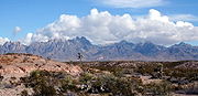
- Organ MountainsOrgan MountainsThe Organ Mountains are a rugged mountain range in southern New Mexico in the Southwestern United States. They lie east of the city of Las Cruces, in Doña Ana County.-Geography:...
- Mesilla Valley Bosque State ParkMesilla Valley Bosque State ParkMesilla Valley Bosque State Park is a state park of New Mexico, USA, preserving a riverside forest along the Rio Grande. The park is located near Las Cruces and just west of Mesilla. The park itself encompasses approximately , at an elevation of ....
- Mesilla, New MexicoMesilla, New MexicoMesilla is a town in Doña Ana County, New Mexico, United States. The population was 2,180 at the 2000 census...
- Mesquite, New MexicoMesquite, New MexicoMesquite is a census-designated place in Doña Ana County, New Mexico, United States. The population was 948 at the 2000 census. It is part of the Las Cruces Metropolitan Statistical Area.-Geography:Mesquite is located at ....
- Vado, New MexicoVado, New MexicoVado is a census-designated place in Doña Ana County, New Mexico, United States. The population was 3,003 at the 2000 census. As of 5 May 2010, its lone ZIP code is 88072, its telephone Area Code is 575, and it is part of the Las Cruces Metropolitan Statistical Area.-Geography:Vado is located at ...
and La Mesa, New Mexico - Berino, New MexicoBerino, New MexicoBerino is an unincorporated community in Doña Ana County, New Mexico, United States. Berino is located along Interstate 10 south of Las Cruces....
- Anthony, New MexicoAnthony, New MexicoAnthony is a city in Doña Ana County, New Mexico, USA. The population was 7,904 at the 2000 census. It is located on the New Mexico–Texas state line in the Upper Mesilla Valley, and on Interstate 10, 27 miles south of Las Cruces and 21 miles north of El Paso, Texas...
- Sunland Park, New MexicoSunland Park, New MexicoSunland Park is a city in Doña Ana County, New Mexico, United States. The population was 14,106 at the 2010 census. Though it lies directly across from El Paso, Texas, being in Doña Ana County makes it instead a part of the Las Cruces Metropolitan Statistical Area, some 30 miles to the north.The...
and El Paso, TexasEl Paso, TexasEl Paso, is a city in and the county seat of El Paso County, Texas, United States, and lies in far West Texas. In the 2010 census, the city had a population of 649,121. It is the sixth largest city in Texas and the 19th largest city in the United States...
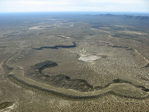
- Potrillo volcanic fieldPotrillo volcanic fieldThe Potrillo Volcanic Field is a monogenetic volcanic field located on the Rio Grande Rift, in a portion of its rift valley, in southern New Mexico, USA and northern Chihuahua, Mexico...
- United States–Mexico borderUnited States–Mexico borderThe United States–Mexico border is the international border between the United States and Mexico. It runs from Imperial Beach, California, and Tijuana, Baja California, in the west to Matamoros, Tamaulipas, and Brownsville, Texas, in the east, and traverses a variety of terrains, ranging from major...
See also
- El Camino Real de Tierra Adentro
- Santa Fe River TrailSanta Fe River (New Mexico)The Santa Fe River is a tributary of the Rio Grande in northern New Mexico. It starts in the Sangre de Cristo mountain range and passes through the state capital, Santa Fe providing approximately 40% of the city's water supply. It is an...
- Santa Fe TrailSanta Fe TrailThe Santa Fe Trail was a 19th-century transportation route through central North America that connected Missouri with Santa Fe, New Mexico. Pioneered in 1822 by William Becknell, it served as a vital commercial and military highway until the introduction of the railroad to Santa Fe in 1880...
- Grand Enchantment TrailGrand Enchantment TrailThe Grand Enchantment Trail is a wilderness recreation trail running between Phoenix, Arizona and Albuquerque, New Mexico. It crosses the Arizona Trail and Continental Divide Trail and at Albuquerque it meets the Rio Grande Trail and El Camino Real de Tierra Adentro.-External links:** -...