
.gif)
Ridgeway (track)
Encyclopedia
Ridgeways are a particular type of ancient road that exploits the hard surface of hilltop ridges for use as unpaved, zero-maintenance roads, though they often have the disadvantage of steeper gradients along their courses, and sometimes quite narrow widths. Before the advent of turnpikes or toll roads
, ridgeway trails continued to provide the firmest and safest cart tracks. They are generally an opposite to level, valley-bottom, paved
roads, which require engineering work to shore up and maintain. Unmaintained valley routes may require greater travelling distances than ridgeways.
Prehistoric roads in Europe often variously comprised stretches of ridgeway above the line of springs, sections of causeway
through bog and marsh, and other trackways of neither sort which crossed flat country.
A revival of interest in ancient roads and recreational walking in the 19th century brought the concept back into common use. Some ancient routes, in particular The Ridgeway
National Trail of southern England, have been reprised as long-distance footpaths
.
 Along ridge lines of hills, soil is often exposed and dry because of wind and natural drainage, and vegetation tends to be thinner. Where a beaten track evolves into a busier "road," constant passage by beasts, sleds and wheeled vehicles suppresses regrowth of vegetation. With the help of rain (and soil creep), a shallow trail can be worn down into the topsoil and smoothed without any purposeful road-making work. The thin soil and rocky subsoil, combined with the natural drainage provided by the slopes on each side, also tended to keep such roads dry.
In western Europe, where prehistoric roads have been extensively documented with the help of itineraries, traces on old maps and extant marks on the landscape, ridgeways are a typical feature of long-distance ancient routes through rugged, high-rainfall parts of Germany and across the island of Great Britain. These ancient trackways generally ran along the hilltops, only descending when necessary to cross valleys.
As such, they are an opposite to modern-style roads, which tend to run along the valleys and only ascend when necessary to cross the hilltops.
 In rugged parts of central Germany, ridgeways tend to strictly follow the watershed line proper, since traversing steep slopes was difficult for wheeled vehicles and uncomfortable for foot travellers unless someone had cut a track into the hillside and shored it up against washouts and slips. However, deviations around high peaks were common, usually taking the south side of the peak, presumably because the warmer side was usually drier. On flatter British hills, the line of the tracks often runs a little below the actual crest of the ridge, possibly to afford some shelter from the wind or to avoid travellers presenting themselves to marauders as a target on the skyline.
The discomfort of following ridgeways arises from their exposure to harsh weather and the fact that they are rarely level. The ridge line rises and falls. Moreover, at some point the ridge ends, so that the route must descend to ford a stream before rising again to follow the next ridge. Loads on two-wheeled carts had to be constantly shifted to the back during descents and to the front during ascents so that the animals could draw efficiently.
In medieval and later times ridgeways in England were used as drovers roads.
Since ridgeways were informal routes, and the rounded tops of many British and German ridges might be hundreds of metres wide, the track might change seasonally, or spontaneously, if any land alongside the trail appeared drier and firmer. But where the tracks were seen as marking boundaries, the course could no longer change without causing a property dispute. English ridgeway routes became fixed in the course of enclosures beginning about 1750.
Notable prehistoric ridgeways include:
in England
in Germany
, even though the prevailing Roman road-construction practice was to build straight roads from point to point, rising and falling with the landscape.
Some German ridgeways were deliberately closed to force traffic into towns. In one instance, the central purpose of the Rheingauer Gebück, a 38-kilometre fence erected in the 12th century, may have been to close down a German ridgeway and force traffic onto the Rhine river. Many ridgeways have continued in use with macadam
or paved
surfaces in modern times. Others fell into disuse when more level paved routes, either along valley bottoms or cut transversely along hillsides, were built parallel to them.
Noting the existence of such parallel routes, antiquarians in Britain came to associate ridgeways culturally with ancient Britons
. However the evidence for the great antiquity of ridgeway routes is ambiguous. In the modern era, new cart tracks have generally avoided inhospitable high ground: the 1840s and 1850s Wagon Trails
from the Missouri River
to Oregon
and California
— rutted trails in bare earth — generally followed low courses.
as a generic term to distinguish any high travel route from a lower one. The earliest extant written form is spelled hrycweg, dating from 938. In German, a variety of terms of similar date match the concept of a ridgeway: Rennweg (since circa 860: Rennewec), Rennstieg (1162: Rinnestich), Bergstrasse (C9: Birgistrotun) and hohe Strasse (circa 1000 Howestraze).
A revival of interest in ancient roads in the 19th century brought the concept back into common use. Although the Great Ridgeway
northwest of London was the best known of such routes, 19th-century British antiquarians rediscovered numerous other local ridgeways and speculated that names such as Ryknild Street (a valley route) contained the word ridge in modified form. Scholars such as Georg Landau (1807–1865) began mapping and walking ancient ridgeway roads across Germany in the 19th century.
Recording prehistoric ridgeways today can be difficult. Trails only lightly worn into soil along ridge lines are generally no longer visible, but their courses are sometimes marked by modern roads and footpaths that have perpetuated the ridgeway routes.
A ridgeway previously used by carts often remains physically evident in the form of a hollow way: a trench or fosse eroded deep into the soil by constant passage of wheels and hooves. These are most common at inclines. Sleds, axles scraping the soil between wheel ruts, locked wheels skidding downhill and heavy weights dragged over the ground to brake the carts' descents would all continue eroding the surface down to the bedrock, if any, which then forms a natural pavement.
When it rains, the mud and debris
in an inclined hollow way tend to be washed down the channel, slowly flushing it out and leaving banks on either side where hedgerows may develop and collect more material. Hollow ways can of course occur in any firm-ground trackway, not just in ridgeway sections. On level sections of a ridgeway, banks are less common' perhaps because travellers avoided large puddles and constantly changed the courses, or because any banks eroded.
 From the 19th century onwards, old ridgeways which had not been converted into highways were often revived by hiking clubs or tourism authorities, marked out as scenic trails for walking, horse-riding or mountain biking far from the disturbances of motor traffic. An 1890 Baedeker
guide recommended walks on The Ridgeway, and efforts to give that ridgeway legislative recognition began in 1947.
Some completely new recreational ridgeways have been devised where there was no tradition of the route being used for trade in previous centuries.
Examples include the Kammweg established in 1904 in eastern Germany and the 197-kilometre Wessex Ridgeway
in England, devised in the 1980s by the Ramblers Association, following ridges between the Atlantic coast and Avebury
, with a preference for firm paths, good scenery and free access.
Toll road
A toll road is a privately or publicly built road for which a driver pays a toll for use. Structures for which tolls are charged include toll bridges and toll tunnels. Non-toll roads are financed using other sources of revenue, most typically fuel tax or general tax funds...
, ridgeway trails continued to provide the firmest and safest cart tracks. They are generally an opposite to level, valley-bottom, paved
Pavement (material)
Road surface or pavement is the durable surface material laid down on an area intended to sustain vehicular or foot traffic, such as a road or walkway. In the past cobblestones and granite setts were extensively used, but these surfaces have mostly been replaced by asphalt or concrete. Such...
roads, which require engineering work to shore up and maintain. Unmaintained valley routes may require greater travelling distances than ridgeways.
Prehistoric roads in Europe often variously comprised stretches of ridgeway above the line of springs, sections of causeway
Causeway
In modern usage, a causeway is a road or railway elevated, usually across a broad body of water or wetland.- Etymology :When first used, the word appeared in a form such as “causey way” making clear its derivation from the earlier form “causey”. This word seems to have come from the same source by...
through bog and marsh, and other trackways of neither sort which crossed flat country.
A revival of interest in ancient roads and recreational walking in the 19th century brought the concept back into common use. Some ancient routes, in particular The Ridgeway
The Ridgeway
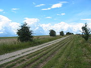
thumb|right|thumb|The ancient tree-lined path winds over the downs countrysideThe Ridgeway is a ridgeway or ancient trackway described as Britain's oldest road...
National Trail of southern England, have been reprised as long-distance footpaths
Long-distance trail
Long-distance trails are the longer recreational trails mainly through rural areas, used for non-motorised recreational travelling ....
.
Origin
In western Europe, where prehistoric roads have been extensively documented with the help of itineraries, traces on old maps and extant marks on the landscape, ridgeways are a typical feature of long-distance ancient routes through rugged, high-rainfall parts of Germany and across the island of Great Britain. These ancient trackways generally ran along the hilltops, only descending when necessary to cross valleys.
As such, they are an opposite to modern-style roads, which tend to run along the valleys and only ascend when necessary to cross the hilltops.
Courses
The discomfort of following ridgeways arises from their exposure to harsh weather and the fact that they are rarely level. The ridge line rises and falls. Moreover, at some point the ridge ends, so that the route must descend to ford a stream before rising again to follow the next ridge. Loads on two-wheeled carts had to be constantly shifted to the back during descents and to the front during ascents so that the animals could draw efficiently.
In medieval and later times ridgeways in England were used as drovers roads.
Since ridgeways were informal routes, and the rounded tops of many British and German ridges might be hundreds of metres wide, the track might change seasonally, or spontaneously, if any land alongside the trail appeared drier and firmer. But where the tracks were seen as marking boundaries, the course could no longer change without causing a property dispute. English ridgeway routes became fixed in the course of enclosures beginning about 1750.
Notable prehistoric ridgeways include:
in England
- The RidgewayThe Ridgewaythumb|right|thumb|The ancient tree-lined path winds over the downs countrysideThe Ridgeway is a ridgeway or ancient trackway described as Britain's oldest road...
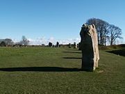
between AveburyAveburyAvebury is a Neolithic henge monument containing three stone circles which is located around the village of Avebury in Wiltshire, south west England. Unique amongst megalithic monuments, Avebury contains the largest stone circle in Europe, and is one of the best known prehistoric sites in Britain...
and StreatleyStreatley, BerkshireStreatley is a village and civil parish on the River Thames in Berkshire, England.-Location:Streatley is about from Reading and from Oxford. It is in the Goring Gap on the River Thames and is directly across the river from the Oxfordshire village of Goring-on-Thames...
in southern England - The Icknield WayIcknield WayThe Icknield Way is an ancient trackway in southern England. It follows the chalk escarpment that includes the Berkshire Downs and Chiltern Hills.-Background:...
on the escarpment of the Chiltern HillsChiltern HillsThe Chiltern Hills form a chalk escarpment in South East England. They are known locally as "the Chilterns". A large portion of the hills was designated officially as an Area of Outstanding Natural Beauty in 1965.-Location:...
and extending towards Norfolk in southern England - The Old Shaftesbury Drove and the Ox Drove leading from ShaftesburyShaftesburyShaftesbury is a town in Dorset, England, situated on the A30 road near the Wiltshire border 20 miles west of Salisbury. The town is built 718 feet above sea level on the side of a chalk and greensand hill, which is part of Cranborne Chase, the only significant hilltop settlement in Dorset...
and Blandford to SalisburySalisburySalisbury is a cathedral city in Wiltshire, England and the only city in the county. It is the second largest settlement in the county...
in Germany
- The Rennweg (Arnsberger Wald), an old trade route along the Arnsberg Forest
- The Brüderstrasse between Cologne and Siegen, Germany
- The RennsteigRennsteigThe Rennsteig is a ridge walk as well as an historical boundary path in the Thuringian Forest, Thuringian Highland and Franconian Forest in central Germany....
from Gerstungen through the Thuringian mountains of Germany, restored from 1896 onwards as a 169-kilometre trail
Evaluation
Some modern authors have suggested several advantages a ridgeway might possess:- A ridgeway trail preserves itself without paving and constant maintenance, which were not available in medieval or early modern times in Europe.
- A watershed route can cover long distances without crossing water: valley roads require fords or bridges over tributary streams.
- In some landscapes, a line along a hill is generally more direct, taking a route as the crow flies, whereas valley routes tend to wind.
- Routes well away from arable land in valleys can avoid tolls and customs charges imposed by land-owners or potentates.
- Despite laws on rights of way, lowland farmers encroach on paths which they themselves do not use. Travellers can bypass villages on higher ground.
- Treeless hilltops may be safer from attack by robbers or fierce animals than densely forested valleys.
Demise
Some ridgeway routes were adopted and paved by the RomansAncient Rome
Ancient Rome was a thriving civilization that grew on the Italian Peninsula as early as the 8th century BC. Located along the Mediterranean Sea and centered on the city of Rome, it expanded to one of the largest empires in the ancient world....
, even though the prevailing Roman road-construction practice was to build straight roads from point to point, rising and falling with the landscape.
Some German ridgeways were deliberately closed to force traffic into towns. In one instance, the central purpose of the Rheingauer Gebück, a 38-kilometre fence erected in the 12th century, may have been to close down a German ridgeway and force traffic onto the Rhine river. Many ridgeways have continued in use with macadam
Macadam
Macadam is a type of road construction pioneered by the Scotsman John Loudon McAdam in around 1820. The method simplified what had been considered state-of-the-art at that point...
or paved
Pavement (material)
Road surface or pavement is the durable surface material laid down on an area intended to sustain vehicular or foot traffic, such as a road or walkway. In the past cobblestones and granite setts were extensively used, but these surfaces have mostly been replaced by asphalt or concrete. Such...
surfaces in modern times. Others fell into disuse when more level paved routes, either along valley bottoms or cut transversely along hillsides, were built parallel to them.
Noting the existence of such parallel routes, antiquarians in Britain came to associate ridgeways culturally with ancient Britons
Britons (historical)
The Britons were the Celtic people culturally dominating Great Britain from the Iron Age through the Early Middle Ages. They spoke the Insular Celtic language known as British or Brythonic...
. However the evidence for the great antiquity of ridgeway routes is ambiguous. In the modern era, new cart tracks have generally avoided inhospitable high ground: the 1840s and 1850s Wagon Trails
Emigrant Trail
The Emigrant Trails were the northern networks of overland wagon trails throughout the American West, used by emigrants from the eastern United States to settle lands west of the Interior Plains during the overland migrations of the mid-19th century...
from the Missouri River
Missouri River
The Missouri River flows through the central United States, and is a tributary of the Mississippi River. It is the longest river in North America and drains the third largest area, though only the thirteenth largest by discharge. The Missouri's watershed encompasses most of the American Great...
to Oregon
Oregon
Oregon is a state in the Pacific Northwest region of the United States. It is located on the Pacific coast, with Washington to the north, California to the south, Nevada on the southeast and Idaho to the east. The Columbia and Snake rivers delineate much of Oregon's northern and eastern...
and California
California
California is a state located on the West Coast of the United States. It is by far the most populous U.S. state, and the third-largest by land area...
— rutted trails in bare earth — generally followed low courses.
Rediscovery
In Britain, the term ridgeway has been in continuous use since Anglo-Saxon timesas a generic term to distinguish any high travel route from a lower one. The earliest extant written form is spelled hrycweg, dating from 938. In German, a variety of terms of similar date match the concept of a ridgeway: Rennweg (since circa 860: Rennewec), Rennstieg (1162: Rinnestich), Bergstrasse (C9: Birgistrotun) and hohe Strasse (circa 1000 Howestraze).
A revival of interest in ancient roads in the 19th century brought the concept back into common use. Although the Great Ridgeway
The Ridgeway
thumb|right|thumb|The ancient tree-lined path winds over the downs countrysideThe Ridgeway is a ridgeway or ancient trackway described as Britain's oldest road...
northwest of London was the best known of such routes, 19th-century British antiquarians rediscovered numerous other local ridgeways and speculated that names such as Ryknild Street (a valley route) contained the word ridge in modified form. Scholars such as Georg Landau (1807–1865) began mapping and walking ancient ridgeway roads across Germany in the 19th century.
Recording prehistoric ridgeways today can be difficult. Trails only lightly worn into soil along ridge lines are generally no longer visible, but their courses are sometimes marked by modern roads and footpaths that have perpetuated the ridgeway routes.
A ridgeway previously used by carts often remains physically evident in the form of a hollow way: a trench or fosse eroded deep into the soil by constant passage of wheels and hooves. These are most common at inclines. Sleds, axles scraping the soil between wheel ruts, locked wheels skidding downhill and heavy weights dragged over the ground to brake the carts' descents would all continue eroding the surface down to the bedrock, if any, which then forms a natural pavement.
When it rains, the mud and debris
Debris
Debris is rubble, wreckage, ruins, litter and discarded garbage/refuse/trash, scattered remains of something destroyed, or, in geology, large rock fragments left by a melting glacier etc. The singular form of debris is debris...
in an inclined hollow way tend to be washed down the channel, slowly flushing it out and leaving banks on either side where hedgerows may develop and collect more material. Hollow ways can of course occur in any firm-ground trackway, not just in ridgeway sections. On level sections of a ridgeway, banks are less common' perhaps because travellers avoided large puddles and constantly changed the courses, or because any banks eroded.
Recreational
Baedeker
Verlag Karl Baedeker is a Germany-based publisher and pioneer in the business of worldwide travel guides. The guides, often referred as simply "Baedekers" , contain important introductions, descriptions of buildings, of museum collections, etc., written by the best specialists, and...
guide recommended walks on The Ridgeway, and efforts to give that ridgeway legislative recognition began in 1947.
Some completely new recreational ridgeways have been devised where there was no tradition of the route being used for trade in previous centuries.
Examples include the Kammweg established in 1904 in eastern Germany and the 197-kilometre Wessex Ridgeway
Wessex Ridgeway
The Wessex Ridgeway is a long distance footpath in England. It runs from Marlborough in Wiltshire to Lyme Regis in Dorset via the edge of Salisbury Plain and Cranborne Chase. The footpath was opened in 1994...
in England, devised in the 1980s by the Ramblers Association, following ridges between the Atlantic coast and Avebury
Avebury
Avebury is a Neolithic henge monument containing three stone circles which is located around the village of Avebury in Wiltshire, south west England. Unique amongst megalithic monuments, Avebury contains the largest stone circle in Europe, and is one of the best known prehistoric sites in Britain...
, with a preference for firm paths, good scenery and free access.
See also
- Ancient trackwayAncient trackwayAncient trackway can refer to any track or trail whose origin is lost in antiquity. Such paths existed from the earliest prehistoric times and in every inhabited part of the globe...
- CausewayCausewayIn modern usage, a causeway is a road or railway elevated, usually across a broad body of water or wetland.- Etymology :When first used, the word appeared in a form such as “causey way” making clear its derivation from the earlier form “causey”. This word seems to have come from the same source by...
- Ford (crossing)Ford (crossing)A ford is a shallow place with good footing where a river or stream may be crossed by wading or in a vehicle. A ford is mostly a natural phenomenon, in contrast to a low water crossing, which is an artificial bridge that allows crossing a river or stream when water is low.The names of many towns...
- Hollow way
- Drainage divide
- RidgeRidgeA ridge is a geological feature consisting of a chain of mountains or hills that form a continuous elevated crest for some distance. Ridges are usually termed hills or mountains as well, depending on size. There are several main types of ridges:...
- List of ancient roadsAncient roadsAncient roads covered major long-distances and there are many other historic roads of significant value.-Europe:In Europe, with the exception of the Roman roads, the paths were not always fixed and at times depended on the topology and geography of the land. In the early Middle Ages, valleys were...
- Trade routeTrade routeA trade route is a logistical network identified as a series of pathways and stoppages used for the commercial transport of cargo. Allowing goods to reach distant markets, a single trade route contains long distance arteries which may further be connected to several smaller networks of commercial...
- Salt roadSalt RoadA salt road ) is any of the prehistoric and historical trade routes by which essential salt has been transported to regions that lacked it ....