.gif)
Resolution Island (Nunavut)
Encyclopedia

Canadian Arctic Archipelago
The Canadian Arctic Archipelago, also known as the Arctic Archipelago, is a Canadian archipelago north of the Canadian mainland in the Arctic...
in Qikiqtaaluk Region, Nunavut
Nunavut
Nunavut is the largest and newest federal territory of Canada; it was separated officially from the Northwest Territories on April 1, 1999, via the Nunavut Act and the Nunavut Land Claims Agreement Act, though the actual boundaries had been established in 1993...
. It is a Baffin Island
Baffin Island
Baffin Island in the Canadian territory of Nunavut is the largest island in the Canadian Arctic Archipelago, the largest island in Canada and the fifth largest island in the world. Its area is and its population is about 11,000...
offshore island located in Hudson Strait
Hudson Strait
Hudson Strait links the Atlantic Ocean to Hudson Bay in Canada. It lies between Baffin Island and the northern coast of Quebec, its eastern entrance marked by Cape Chidley and Resolution Island. It is long...
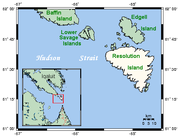
. It has an area of 1015 km² (391.9 sq mi). The Lower Savage Islands
Lower Savage Islands
The Lower Savage Islands are an uninhabited offshore island group of Baffin Island, located in the Canadian Arctic Archipelago in the territory of Nunavut. The islands lie in...
lie between Resolution Island and Baffin Island, while Graves Strait separates Resolution Island from the more northern Edgell Island
Edgell Island
Edgell Island is one of Baffin Island's small offshore islands, located in the Canadian Arctic Archipelago in the territory of Nunavut. It lies in Hudson Strait, near the entrance into Frobisher Bay. Graves Strait, about long and wide, separates it from Resolution Island. Edgell Island has an...
.
History
English explorer Martin FrobisherMartin Frobisher
Sir Martin Frobisher was an English seaman who made three voyages to the New World to look for the Northwest Passage...
landed on the island on July 28, 1576, while on a voyage to discover the fabled Northwest Passage
Northwest Passage
The Northwest Passage is a sea route through the Arctic Ocean, along the northern coast of North America via waterways amidst the Canadian Arctic Archipelago, connecting the Atlantic and Pacific Oceans...
.
The island was home to an American military base, now CFS Resolution Island
CFS Resolution Island
CFS Resolution Island is a short-range radar site. It is located north-northwest of CFB Goose Bay, Labrador and Newfoundland. It is part of the North Warning System...
, that became operational in 1954 as part of the Distant Early Warning
Distant Early Warning Line
The Distant Early Warning Line, also known as the DEW Line or Early Warning Line, was a system of radar stations in the far northern Arctic region of Canada, with additional stations along the North Coast and Aleutian Islands of Alaska, in addition to the Faroe Islands, Greenland, and Iceland...
(DEW) line. The base was vacated in 1973 and turned over to the Canadian government in 1974.
It was during site investigations between 1987 and 1990 that contamination at the site was first discovered. The contamination originates largely from spills from the radar equipment, which used polychlorinated biphenyl
Polychlorinated biphenyl
Polychlorinated biphenyls are a class of organic compounds with 2 to 10 chlorine atoms attached to biphenyl, which is a molecule composed of two benzene rings. The chemical formula for PCBs is C12H10-xClx...
s (PCBs) as insulators. Other pollutants include unused transformer fluids, hydrocarbon
Hydrocarbon
In organic chemistry, a hydrocarbon is an organic compound consisting entirely of hydrogen and carbon. Hydrocarbons from which one hydrogen atom has been removed are functional groups, called hydrocarbyls....
s, asbestos
Asbestos
Asbestos is a set of six naturally occurring silicate minerals used commercially for their desirable physical properties. They all have in common their eponymous, asbestiform habit: long, thin fibrous crystals...
and heavy metals
Heavy metals
A heavy metal is a member of a loosely-defined subset of elements that exhibit metallic properties. It mainly includes the transition metals, some metalloids, lanthanides, and actinides. Many different definitions have been proposed—some based on density, some on atomic number or atomic weight,...
in the buildings and sprinkled throughout the site. Resolution Island has been identified as having the highest level of PCB contamination of all former military sites that fall under Indian and Northern Affairs Canada
Indian and Northern Affairs Canada
The Department of Aboriginal Affairs and Northern Development is the department of the government of Canada with responsibility for policies relating to Aboriginal peoples...
’s (INAC) responsibility in the North.
In 1993 and 1994, an environmental site assessment of the area was completed. As a result, temporary barriers were placed across drainage paths to stop the migration of PCBs into the water. Further investigations were done and, in 1997, INAC initiated remediation work with Qikiqtaaluk Corporation (QC). A large-scale remediation plan was developed, in cooperation with Environment Canada
Environment Canada
Environment Canada , legally incorporated as the Department of the Environment under the Department of the Environment Act Environment Canada (EC) (French: Environnement Canada), legally incorporated as the Department of the Environment under the Department of the Environment Act Environment...
, QC and Queen’s University. Steps were taken at that time to ensure that the contaminants were not posing a risk to humans and wildlife.

