

Quitchupah Creek
Encyclopedia
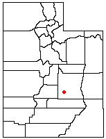
Sevier County, Utah
As of the census of 2000, there were 18,842 people, 6,081 households, and 4,907 families residing in the county. The population density was 10 people per square mile . There were 7,016 housing units at an average density of 4 per square mile...
Counties in central Utah
Utah
Utah is a state in the Western United States. It was the 45th state to join the Union, on January 4, 1896. Approximately 80% of Utah's 2,763,885 people live along the Wasatch Front, centering on Salt Lake City. This leaves vast expanses of the state nearly uninhabited, making the population the...
, in the western United States
United States
The United States of America is a federal constitutional republic comprising fifty states and a federal district...
. Quitchupah Creek is significant for its rock art remains of the Fremont culture
Fremont culture
The Fremont culture or Fremont people is a pre-Columbian archaeological culture which received its name from the Fremont River in the U.S. state of Utah where the first Fremont sites were discovered. The Fremont River itself is named for John Charles Frémont, an American explorer. It inhabited...
that line its banks. Quitchupah is Ute
Ute Tribe
The Ute are an American Indian people now living primarily in Utah and Colorado. There are three Ute tribal reservations: Uintah-Ouray in northeastern Utah ; Southern Ute in Colorado ; and Ute Mountain which primarily lies in Colorado, but extends to Utah and New Mexico . The name of the state of...
for "animals fare poorly." The drainage area is located within the Colorado River
Colorado River
The Colorado River , is a river in the Southwestern United States and northwestern Mexico, approximately long, draining a part of the arid regions on the western slope of the Rocky Mountains. The watershed of the Colorado River covers in parts of seven U.S. states and two Mexican states...
Basin near the south end of the Wasatch Plateau. All drainage from the area flows to Quitchupah Creek or its tributaries, including East Spring Canyon, Water Hollow, and North Fork and flows through Convulsion Canyon.
It begins at an elevation of 9,000 feet above sea level. It exits Convulsion Canyon and crosses under Utah State Route 10
Utah State Route 10
State Route 10 is a State Highway in the U.S. state of Utah. The highway follows a long valley in Eastern Utah between the Wasatch Plateau on the west and the San Rafael Swell on the east....
, south of the town of Emery
Emery, Utah
Emery is a town in Emery County, Utah, United States. The population was 308 at the 2000 census.-Prehistoric:Emery sits at the base of the mountains that contain the North Horn Formation. Named after North Horn Mountain, near Castle Dale, Utah this formation in Emery County contain numerous...
, and then flows southeasterly and intersects with Ivie Creek, which ultimately merges with Muddy Creek
Muddy Creek
Muddy Creek may refer to:*Muddy Creek , a tributary of the Colorado River*Muddy Creek *Muddy Creek *Muddy Creek , a list of Muddy Creeks in the state*In Pennsylvania...
and passing the Hidden Splendor Mine area, it passes through the San Rafael Reef
San Rafael Reef
The San Rafael Reef is a geologic feature located in Emery County in central Utah, part of the Colorado Plateau. Approximately 75 miles long, it is the name given to the distinctive eastern edge of the San Rafael Swell...
at the Muddy Creek Gorge. Finally, after an estimated length of 100 miles (160 km) and a drop of 6000 feet (1825 m), it combines with the Fremont River to form the Dirty Devil River
Dirty Devil River
The Dirty Devil River is a long tributary of the Colorado River, located in the U.S. state of Utah. It flows through southern Utah from the confluence of Fremont River and Muddy Creek to the Colorado River.-Course:...
just north of the town of Hanksville
Hanksville, Utah
Hanksville is a small town in Wayne County, Utah, United States, at the junction of State Routes 24 and 95. The town is just south of the confluence of the Fremont River and Muddy Creek, which together form the Dirty Devil River, which then flows southeast to the Colorado River...
.
The Old Spanish Trail
Old Spanish Trail
Old Spanish Trail may refer to:*Old Spanish Trail , connecting Santa Fe, New Mexico with Los Angeles, California in the 19th century...
crossed Quitchupah Creek. Mormon
Mormon
The term Mormon most commonly denotes an adherent, practitioner, follower, or constituent of Mormonism, which is the largest branch of the Latter Day Saint movement in restorationist Christianity...
settlers moved along its banks in the 1880s, but the settlement was later abandoned. Quitchupah Creek was recently in the news for a proposed road along the creek from Convulsion Canyon coal mines to Utah State Route 10.