

Promontory Mountains
Encyclopedia
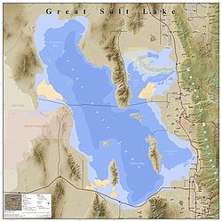
The Promontory Mountains are a range
in Box Elder County, Utah
. The range is oriented north-south and has a length of about 35 miles (56.3 km). The southern portion forms a cape
extending 20 miles (32.2 km) south into the Great Salt Lake
. Promontory Point
is at the southern tip of the range, and the First Transcontinental Railroad
was completed with the Golden Spike
just north of the range at Promontory Summit in the Utah Territory
. Today, trains cross the point via the Lucin Cutoff
railroad causeway
across the lake.
and on to the south shore of the lake to the west side of the Oquirrh Mountains
where it continues on strike
as the Oquirrh Fault. The East Antelope Island fault runs from the east side of Antelope Island to the north beneath the lake to the east side of the Promentaries where it continues as the East Promontory Mountains fault zone. These two fault systems parallel the larger Wasatch Fault
which runs to the east of Great Salt Lake. The faults are normal faults which dip to the west.
(north) and the replacement 1904 Lucin Cutoff
trestle through Promontory Point (south), which was replaced by a 1959 causeway
.
Mountain range
A mountain range is a single, large mass consisting of a succession of mountains or narrowly spaced mountain ridges, with or without peaks, closely related in position, direction, formation, and age; a component part of a mountain system or of a mountain chain...
in Box Elder County, Utah
Box Elder County, Utah
Box Elder County is a county located in the U.S. state of Utah. It lies on the north end of the Great Salt Lake, covering a large area north to the Idaho border and west to the Nevada border. Included in this area are large tracts of barren desert, contrasted by high, forested mountains. The...
. The range is oriented north-south and has a length of about 35 miles (56.3 km). The southern portion forms a cape
Cape (geography)
In geography, a cape or headland is a point or body of land extending into a body of water, usually the sea.A cape usually represents a marked change in trend of the coastline. Their proximity to the coastline makes them prone to natural forms of erosion, mainly tidal actions. This results in capes...
extending 20 miles (32.2 km) south into the Great Salt Lake
Great Salt Lake
The Great Salt Lake, located in the northern part of the U.S. state of Utah, is the largest salt water lake in the western hemisphere, the fourth-largest terminal lake in the world. In an average year the lake covers an area of around , but the lake's size fluctuates substantially due to its...
. Promontory Point
Promontory Point, Utah
Promontory Point, Utah, is the southernmost edge of the Promontory Mountains in southern Box Elder County, Utah, centered approximately at , with an elevation of 1285 meters above sea level...
is at the southern tip of the range, and the First Transcontinental Railroad
First Transcontinental Railroad
The First Transcontinental Railroad was a railroad line built in the United States of America between 1863 and 1869 by the Central Pacific Railroad of California and the Union Pacific Railroad that connected its statutory Eastern terminus at Council Bluffs, Iowa/Omaha, Nebraska The First...
was completed with the Golden Spike
Golden spike
The "Golden Spike" is the ceremonial final spike driven by Leland Stanford to join the rails of the First Transcontinental Railroad across the United States connecting the Central Pacific and Union Pacific railroads on May 10, 1869, at Promontory Summit, Utah Territory...
just north of the range at Promontory Summit in the Utah Territory
Utah Territory
The Territory of Utah was an organized incorporated territory of the United States that existed from September 9, 1850, until January 4, 1896, when the final extent of the territory was admitted to the Union as the State of Utah....
. Today, trains cross the point via the Lucin Cutoff
Lucin Cutoff
The Lucin Cutoff is a railroad line which included a railroad trestle which crossed the Great Salt Lake in Utah. Built by the Southern Pacific Company between February 1902 and March 1904 across Promontory Point, it bypassed the original Central Pacific Railroad route through Promontory Summit...
railroad causeway
Causeway
In modern usage, a causeway is a road or railway elevated, usually across a broad body of water or wetland.- Etymology :When first used, the word appeared in a form such as “causey way” making clear its derivation from the earlier form “causey”. This word seems to have come from the same source by...
across the lake.
Geology
The Promontory Mountains are a block fault range typical of the Basin and Range Province. The west side of the range is bounded by the East Great Salt Lake normal fault which passes under the lake along the west side of Antelope IslandAntelope Island
Antelope Island, with an area of , is the largest island of 10 islands located within the Great Salt Lake, Utah, United States. The island lies in the southeastern portion of the lake, near Salt Lake City and Davis County, and becomes a peninsula when the lake is at extremely low levels. Antelope...
and on to the south shore of the lake to the west side of the Oquirrh Mountains
Oquirrh Mountains
The Oquirrh Mountains is a mountain range that run north-south for approximately 30 miles to form the west side of Utah's Salt Lake Valley, separating it from Tooele Valley. The range begins in northwest Utah County and stops at the south shore of the Great Salt Lake. The highest elevation is...
where it continues on strike
Strike and dip
Strike and dip refer to the orientation or attitude of a geologic feature. The strike line of a bed, fault, or other planar feature is a line representing the intersection of that feature with a horizontal plane. On a geologic map, this is represented with a short straight line segment oriented...
as the Oquirrh Fault. The East Antelope Island fault runs from the east side of Antelope Island to the north beneath the lake to the east side of the Promentaries where it continues as the East Promontory Mountains fault zone. These two fault systems parallel the larger Wasatch Fault
Wasatch Fault
The Wasatch Fault is an earthquake fault located primarily on the western edge of the Wasatch Mountains in the U.S. state of Utah. The fault is 240 miles long, stretching from southern Idaho, through northern Utah, before terminating in central Utah near the town of Fayette...
which runs to the east of Great Salt Lake. The faults are normal faults which dip to the west.
History
The Promontory Mountains of 35 mi (56.3 km) were bypassed by the First Transcontinental RailroadFirst Transcontinental Railroad
The First Transcontinental Railroad was a railroad line built in the United States of America between 1863 and 1869 by the Central Pacific Railroad of California and the Union Pacific Railroad that connected its statutory Eastern terminus at Council Bluffs, Iowa/Omaha, Nebraska The First...
(north) and the replacement 1904 Lucin Cutoff
Lucin Cutoff
The Lucin Cutoff is a railroad line which included a railroad trestle which crossed the Great Salt Lake in Utah. Built by the Southern Pacific Company between February 1902 and March 1904 across Promontory Point, it bypassed the original Central Pacific Railroad route through Promontory Summit...
trestle through Promontory Point (south), which was replaced by a 1959 causeway
Causeway
In modern usage, a causeway is a road or railway elevated, usually across a broad body of water or wetland.- Etymology :When first used, the word appeared in a form such as “causey way” making clear its derivation from the earlier form “causey”. This word seems to have come from the same source by...
.