

Poznań Old Town
Encyclopedia
Poznan
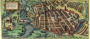
Poznań is a city on the Warta river in west-central Poland, with a population of 556,022 in June 2009. It is among the oldest cities in Poland, and was one of the most important centres in the early Polish state, whose first rulers were buried at Poznań's cathedral. It is sometimes claimed to be...
in western Poland, covering the area of the walled medieval city of Poznań. It is called Stare Miasto in Polish (although that name may also refer to the wider administrative district of Stare Miasto, which extends to most of the city centre and northern parts of the city).
The original settlement of Poznań was on the river island of Ostrów Tumski
Ostrów Tumski, Poznań
Ostrów Tumski is an island between two branches of the river Warta in the city of Poznań in western Poland. Poznań Cathedral and other ecclesiastical buildings occupy the central part of the island...
, and dates from at least the 9th century. The Old Town neighbourhood, however, corresponds to the city on the left bank of the Warta, to the west of Ostrów Tumski, which received its charter in 1253 (work on the Royal Castle
Royal Castle, Poznan
The Royal Castle in Poznań dates from 1249 and the reign of Przemysł I. Located in the Polish city of Poznań, it was largely destroyed during the Second World War but has since been partly rebuilt.-History and modern view:...
, which would be at the western side of the ring of walls, began several years earlier). The city walls were taken down when the city expanded in the early 19th century, but the street layout of the Old Town still corresponds closely to that of the former walled city, with a grid of narrow streets. Surviving fragments of the walls, some of which have been further reconstructed, can be seen on ul. Stawna and ul. Masztalarska in the north, and next to Chopin Park in the south.
The Old Town is centred on Stary Rynek, the Old Market Square. The historic Town Hall (Ratusz) stands in the middle of that square. At the western end of the Old Town is the hill (Góra Przemysła) on which the castle stood.
Old Market Square
The Old Market Square (Stary Rynek) is the large square on which the Old Town neighbourhood is centred. The sides of the square measure approximately 140 metres (459.3 ft). There is a group of buildings in the central part of the square, chief of which is the Old Town Hall (Ratusz). On each side of the square are tall rows of former tenement houses (kamieniceKamienica (architecture)
Kamienica is a Polish term describing a type of residential building made of brick or stone, with at least 2 floors. The word is usually used to describe a building which is incorporated with other, similar buildings....
), many of which are now used as restaurants, cafés and pubs (often with outdoor tables on the square itself). The square was originally laid out in around 1253, with each side divided into 16 equal plots, and many changes to architectural layout and style were made over the centuries. Major changes were made from 1550 onwards by Giovanni Battista di Quadro
Giovanni Battista di Quadro
Giovanni Battista di Quadro was a Polish-Italian renaissance architect, one of the most famous architects in Central Europe in his epoque....
, who reconstructed the Town Hall and several other buildings in Renaissance
Renaissance
The Renaissance was a cultural movement that spanned roughly the 14th to the 17th century, beginning in Italy in the Late Middle Ages and later spreading to the rest of Europe. The term is also used more loosely to refer to the historical era, but since the changes of the Renaissance were not...
style (severe damage had been done to the buildings by a fire of 1536). Most of the buildings in the square were reconstructed following heavy damage in the Battle of Poznań (1945)
Battle of Poznan (1945)
The Battle of Poznań during World War II in 1945 was a massive assault by the Soviet Union's Red Army that had as its objective the elimination of the Nazi German garrison in the stronghold city of Poznań in occupied Poland...
.
The central group of buildings includes:
- The Old Town Hall (see separate article), standing in the north-east corner of the central building group (facing east).
- A row of merchants' houses (domki budnicze), dating from the 16th century, painted in a multicoloured design (1953–1961), with an arcadeArcade (architecture)An arcade is a succession of arches, each counterthrusting the next, supported by columns or piers or a covered walk enclosed by a line of such arches on one or both sides. In warmer or wet climates, exterior arcades provide shelter for pedestrians....
containing souvenir stalls, facing east. One of the houses (no. 17) displays the coat of arms – a herring and three palms – of the merchants' guildGuildA guild is an association of craftsmen in a particular trade. The earliest types of guild were formed as confraternities of workers. They were organized in a manner something between a trade union, a cartel, and a secret society...
from which the houses take their name. - The former town chancellery, adjoining the merchants' houses, facing south.
- The old town weighing house (Waga Miejska), behind the Town Hall, facing north. This was first built 1532–1534, reconstructed 1563, demolished as unsafe in 1890 (replaced by a Renaissance-style "new town hall" used by the city government, heavily damaged in 1945), rebuilt in its former style in 1950–1960 based on surviving prints, renovated in 2002, now used for weddings and other functions.
- The guardhouseGuardhouseA guardhouse is a building used to house personnel and security equipment...
(Odwach), facing west, originally a 18th-century wooden building, rebuilt in ClassicalClassical architectureClassical architecture is a mode of architecture employing vocabulary derived in part from the Greek and Roman architecture of classical antiquity, enriched by classicizing architectural practice in Europe since the Renaissance...
style in 1783–1787, heavily damaged in 1945, rebuilt 1949–1951 and used as a museum. It now houses a museum dedicated to the Greater Poland Uprising (1918–1919)Greater Poland Uprising (1918–1919)The Greater Poland Uprising of 1918–1919, or Wielkopolska Uprising of 1918–1919 or Posnanian War was a military insurrection of Poles in the Greater Poland region against Germany...
. - The Arsenał gallery, a post-war building (1959–1962), standing on the site of a former market building which was used as an arsenalArsenalAn arsenal is a place where arms and ammunition are made, maintained and repaired, stored, issued to authorized users, or any combination of those...
from the 17th century, and was destroyed in 1945. - The Wielkopolska Military Museum, a modern building (1959–1962) standing on the site of a former cloth hallCloth hallA cloth hall or linen hall is a historic building located in the centre of main marketplaces of European towns. They contained trading stalls, particularly for the selling of cloth as well as leather, wax and salt, including exotic imports such as spices and silk...
(sukiennice). The cloth hall existed from 1386 (reconstructed in 1563) until being converted into houses in the 19th century (destroyed in World War II).
Notable houses among those around the edge of the square include:
- nos. 45, 46 and 47 on the east side of the square, which house a Museum of Musical Instruments.
- no. 48, a reconstructed Gothic building, behind which archaeologists have discovered the remains of a late 13th-century merchant's house, the oldest known brick building in the left-bank city, which probably belonged to the city's founder, Thomas of GubenGubenGuben is a town on the Lusatian Neisse river in the state of Brandenburg, Germany. Located in the Spree-Neiße district, Guben has a population of 20,049...
. - no. 50, a reconstructed late-Gothic building, on whose wall is a plaque showing the maximum water level during the city's worst ever flood in 1736.
- no. 78 on the west side, known as the "Działyńskis' palace".
- no. 91 on the north side, known as the "Mielżyńskis' palace".
Other features of the square are a punishment post ("pranger
Pranger
The pranger is a German physical punishment device related to the stocks and the pillory. The Middle Low German word means something that pinches badly.The pranger chained the victim's neck to a pair of leg restraints fastened around the ankles...
", Polish pręgierz) and a fountain depicting Proserpina
Proserpina
Proserpina or Proserpine is an ancient Roman goddess whose story is the basis of a myth of Springtime. Her Greek goddess' equivalent is Persephone. The probable origin of her name comes from the Latin, "proserpere" or "to emerge," in respect to the growing of grain...
, on the eastern side in front of the Town Hall; a statue of St. John Nepomucene; and fountains depicting the gods Apollo
Apollo
Apollo is one of the most important and complex of the Olympian deities in Greek and Roman mythology...
, Neptune and Mars. Within the central group of buildings is a water fountain depicting a Bamber
Bambrzy
Bambrzy are Poles who are partly descended from Germans who moved from the area of Bamberg to villages surrounding Poznań, Poland...
woman (Bamberka).
Streets in the Old Town

The following is a list of present-day names of streets within the area of the former walled city (ul. stands for ulica, meaning "street").
Streets to the north of the market square:
- ul. Stawna ("Pond Street"), approximately following the line of the northern section of the former town walls.
- ul. Masztalarska ("Stableman Street"), running west and then south at the north-east corner of the Old Town. Part of a bastionBastionA bastion, or a bulwark, is a structure projecting outward from the main enclosure of a fortification, situated in both corners of a straight wall , facilitating active defence against assaulting troops...
from the town wall system (mostly reconstructed) stands adjacent to the street. There is also a section of wall, again mostly reconstructed, running between Masztalarska and Stawna (up to the Wronki Gate). - ul. Mokra ("Wet Street"), connecting Wroniecka and Żydowska.
- ul. Dominikańska ("DominicanDominican OrderThe Order of Preachers , after the 15th century more commonly known as the Dominican Order or Dominicans, is a Catholic religious order founded by Saint Dominic and approved by Pope Honorius III on 22 December 1216 in France...
Street"), running east from Żydowska. - ul. Kramarska ("Stallkeepers' Street"), parallel to the north edge of the market square.
- ul. 23 Lutego ("February 23rd Street"), an extension of Kramarska, leading west out of the Old Town neighbourhood (its name commemorates the day of victory in the 1945 Battle of PoznańBattle of Poznan (1945)The Battle of Poznań during World War II in 1945 was a massive assault by the Soviet Union's Red Army that had as its objective the elimination of the Nazi German garrison in the stronghold city of Poznań in occupied Poland...
). - ul. Szewska ("Tailors' Street"), running north and south from Dominikańska.
- ul. Żydowska ("Jewish Street"), running north from the north-east corner of the square. The north-eastern part of the town was formerly the Jewish QuarterJewish QuarterThe Jewish Quarter is one of the four traditional quarters of the Old City of Jerusalem. The 116,000 square meter area lies in the southeastern sector of the walled city, and stretches from the Zion Gate in the south, along the Armenian Quarter on the west, up to the Street of the Chain in the...
. - ul. Wroniecka ("WronkiWronkiWronki is a town in the Szamotuły County, western-central Poland, situated in the Greater Poland Voivodeship , previously in Piła Voivodeship . It is located close to the Warta River to the northwest of Poznań, and has a population of approximately 11,000...
Street"), running north, centrally in relation to the square. It led to the Wronki Gate (Brama Wroniecka), beginning a northward route which crossed the Warta river at Wronki. - ul. Rynkowa ("Market Street"), a short street between the north-west corner of the square and Kramarska.
Streets to the east of the market square:
- ul. Wielka ("Great Street"), running east from the north-east corner of the square. It led to the "Great Gate" (Brama Wielka), the main eastern exit from the town towards the cathedral.
- ul. Woźna ("Carriage Street"), running east, centrally in relation to the square.
- ul. Wodna ("Water Street"), running east from the south-east corner of the square. It led to the "Water Gate" (Brama Wodna), which gave access to the island of Grobla; the name alludes to the river. On the street close to the market square is the former "palace" of the Górka family, now an archeological museum.
- ul. Klasztorna ("Abbey Street"), parallel to the east side of the square.
- ul. Ślusarska ("Metalworkers' Street"), parallel to and east of Klasztorna.
Streets to the south of the market square:
- ul. Kozia ("Goat Street"), parallel to the south side of the square. It was probably named after a sign showing goats (the name was originally applied to ul. Świętosławska).
- ul. Gołębia ("Pigeon Street"), parallel to and south of Kozia.
- ul. Jaskółcza ("Swallow Street"), connecting Szkolna and Wrocławska, south of Gołębia, on the line of the former walls.
- ul. Szkolna ("School Street"), running south from the south-west corner of the square.
- ul. Wrocławska ("Wrocław Street"), running south, centrally in relation to the square.
- ul. Świętosławska, running south from the south-east corner of the square, to the Fara (traditional parish church). It is named after St. Świętosław, the church's patron.
- Plac Kolegiacki, a square at the east end of Kozia and Gołębia, with the former Jesuit College, which now serves as the city government's offices, on its southern side.
- ul. Za Bramką ("Beyond the Gate"), leading south from Plac Kolegiacki.
(For ul. Klasztorna, which extends as far as Gołębia, see above.)
Streets to the west of the market square:
- ul. Paderewskiego ("Paderewski Street"), running west from the south-east corner of the square. This street was extended westwards at the time of the demolition of the city walls at the start of the 19th century, to connect the Old Town with the new district around today's Plac Wolności. Its present name is linked to the speech given by Ignacy Paderewski at the Bazar hotel (whose building stands at the western end of the street) in 1918, precipitating the Greater Poland Uprising.
- ul. Franciszkańska ("FranciscanFranciscanMost Franciscans are members of Roman Catholic religious orders founded by Saint Francis of Assisi. Besides Roman Catholic communities, there are also Old Catholic, Anglican, Lutheran, ecumenical and Non-denominational Franciscan communities....
Street"), running west, centrally in relation to the square. A Franciscan monastery stands there. - Góra Przemysława ("Przemysław's (Przemysł's) Hill"), a street named after the hill on which the Royal CastleRoyal Castle, PoznanThe Royal Castle in Poznań dates from 1249 and the reign of Przemysł I. Located in the Polish city of Poznań, it was largely destroyed during the Second World War but has since been partly rebuilt.-History and modern view:...
stood, running on the slope of that hill, between Zamkowa and Franciszkańska. - ul. Zamkowa ("Castle Street"), a short street leading west and then north, from the north-west corner of the square.
- ul. Sieroca ("Orphan Street"), parallel to the west side of the square.
- ul. Murna ("Wall Street"), connecting Paderewskiego and Kozia.
- ul. Ludgardy, connecting Paderewskiego and Franciszkańska, on the line of the former walls. A monument to the Greater Poland Uprising (1918) stands there.