

Pottsville Formation
Encyclopedia
Pennsylvanian
The Pennsylvanian is, in the ICS geologic timescale, the younger of two subperiods of the Carboniferous Period. It lasted from roughly . As with most other geochronologic units, the rock beds that define the Pennsylvanian are well identified, but the exact date of the start and end are uncertain...
Pottsville Formation is a mapped bedrock unit in Pennsylvania
Pennsylvania
The Commonwealth of Pennsylvania is a U.S. state that is located in the Northeastern and Mid-Atlantic regions of the United States. The state borders Delaware and Maryland to the south, West Virginia to the southwest, Ohio to the west, New York and Ontario, Canada, to the north, and New Jersey to...
, western Maryland
Maryland
Maryland is a U.S. state located in the Mid Atlantic region of the United States, bordering Virginia, West Virginia, and the District of Columbia to its south and west; Pennsylvania to its north; and Delaware to its east...
, West Virginia
West Virginia
West Virginia is a state in the Appalachian and Southeastern regions of the United States, bordered by Virginia to the southeast, Kentucky to the southwest, Ohio to the northwest, Pennsylvania to the northeast and Maryland to the east...
, and Ohio
Ohio
Ohio is a Midwestern state in the United States. The 34th largest state by area in the U.S.,it is the 7th‑most populous with over 11.5 million residents, containing several major American cities and seven metropolitan areas with populations of 500,000 or more.The state's capital is Columbus...
. The formation is also recognized in Alabama
Alabama
Alabama is a state located in the southeastern region of the United States. It is bordered by Tennessee to the north, Georgia to the east, Florida and the Gulf of Mexico to the south, and Mississippi to the west. Alabama ranks 30th in total land area and ranks second in the size of its inland...
. It is a major ridge-former In the Ridge-and-Valley Appalachians
Ridge-and-valley Appalachians
The Ridge-and-Valley Appalachians, also called the Ridge and Valley Province or the Valley and Ridge Appalachians, are a physiographic province of the larger Appalachian division and are also a belt within the Appalachian Mountains extending from southeastern New York through northwestern New...
of the eastern United States
United States
The United States of America is a federal constitutional republic comprising fifty states and a federal district...
. The Pottsville Formation is conspicuous at many sites along the Allegheny Front
Allegheny Front
The Allegheny Front is the major southeast- or east-facing escarpment in the Allegheny Mountains in southern Pennsylvania, western Maryland, and eastern West Virginia, USA. The Allegheny Front delineates the Ridge-and-Valley Appalachians to its east from the Appalachian Plateau to its west...
, the eastern escarpment of the Allegheny or Appalachian Plateau
Appalachian Plateau
The Appalachian Plateau is the western part of the Appalachian mountains, stretching from New York and Alabama. The plateau is a second level United States physiographic region....
.
Description
The Pottsville Formation consists of a gray conglomerateConglomerate (geology)
A conglomerate is a rock consisting of individual clasts within a finer-grained matrix that have become cemented together. Conglomerates are sedimentary rocks consisting of rounded fragments and are thus differentiated from breccias, which consist of angular clasts...
, fine to coarse grained sandstone
Sandstone
Sandstone is a sedimentary rock composed mainly of sand-sized minerals or rock grains.Most sandstone is composed of quartz and/or feldspar because these are the most common minerals in the Earth's crust. Like sand, sandstone may be any colour, but the most common colours are tan, brown, yellow,...
, and is known to contain limestone
Limestone
Limestone is a sedimentary rock composed largely of the minerals calcite and aragonite, which are different crystal forms of calcium carbonate . Many limestones are composed from skeletal fragments of marine organisms such as coral or foraminifera....
, siltstone
Siltstone
Siltstone is a sedimentary rock which has a grain size in the silt range, finer than sandstone and coarser than claystones.- Description :As its name implies, it is primarily composed of silt sized particles, defined as grains 1/16 - 1/256 mm or 4 to 8 on the Krumbein phi scale...
and shale
Shale
Shale is a fine-grained, clastic sedimentary rock composed of mud that is a mix of flakes of clay minerals and tiny fragments of other minerals, especially quartz and calcite. The ratio of clay to other minerals is variable. Shale is characterized by breaks along thin laminae or parallel layering...
, as well as anthracite and bituminous
Bituminous coal
Bituminous coal or black coal is a relatively soft coal containing a tarlike substance called bitumen. It is of higher quality than lignite coal but of poorer quality than Anthracite...
coal.
It is considered a classic orogenic molasse
Molasse
The term "molasse" refers to the sandstones, shales and conglomerates formed as terrestrial or shallow marine deposits in front of rising mountain chains. The molasse is deposited in a foreland basin, especially on top of flysch, for example that left from the rising Alps, or erosion in the Himalaya...
. The formation was first described from a railroad cut south of Pottsville, Pennsylvania
Pottsville, Pennsylvania
Pottsville is the only city in and the county seat of Schuylkill County, Pennsylvania, United States. The population was 15,549 at the 2000 census. The city lies along the west bank of the Schuylkill River, north-west of Philadelphia...
.
Nomenclature and Stratigraphy
The relationship to the term "Pottsville" and actual litholgic units is complex. Most fundamentally, the unit may be considered a Formation or a Group.As a Formation, the Pottsville may encompass the following members depending on the state in which it occurs: Alton Coal Member, Anthony Shale Member, Bear Run Member, Bedford Clay Bed, Boggs Member, Boyles Sandstone Member, Bremen Sandstone Member, Brookville Clay Member, Camp Branch Sandstone Member, Campbell Ledge Shale Member, Chestnut Sandstone Member, Connoquenessing Sandstone Member, Dundee Sandstone Member, Flint Ridge Clay Bed or Flint Ridge Shale Member, Harrison Member, Homewood Sandstone Member, Huckleberry Clay Bed, Kanawha Member, Lick Creek Sandstone Member, Lowellville Limestone Member, Lower Mercer Limestone Member, Massilon Sandstone Member, McArthur Member, Mercer Member, Middle Mercer Shale Member, Mount Savage Clay Bed, Olean Conglomerate Member of Olean Sandstone Member, Pine Sandstone Member, Poverty Run Member, Razburg Sandstone Member, Rocky Ridge Sandstone Member, Schuylkill Member, Sciotoville Clay Member, Shades Sandstone Member, Sharon Coal Bed, Sharon Member, Sharp Mountain Member, Straight Ridge Sandstone Member, Straven Conglomerate Member, Tionesta Clay Bed, Tumbling Run Member, Upper Mercer Limestone Member or Upper Mercer Bed, Vandusen Shale Member, Wolf Ridge Sandstone Member.
As a Group, the Pottsville may encompass the following Formations depending on the state in which it occurs: Connoquenessing Formation, Curwensville Formation, Elliott Park Formation, Gurnee Formation, Hance Formation, Homewood Formation or Homewood Sandstone, Mercer Formation, New River Formation, Olean Conglomerate or Olean Formation, Pocahontas Formation, Schuylkill Formation, Sharon Formation or Sharon Sandstone, Sharp Mountain Formation, Tumbling Run Formation.
The Pottsville was previously mapped in the Illinois basin as well at the Formation level, but was renamed the Tradewater Formation in 1997.
Fossils
A 1.3-m interval at the base of the Pottsville in the Broad TopBroad Top
Broad Top is a plateau located in south-central Pennsylvania. It extends into Huntingdon County to the north, Fulton County to the southeast, and Bedford County to the southwest. It is bounded to the west by Saxton Mountain and Terrace Mountain, and to the east by Sideling Hill. In Bedford...
basin in Pennsylvania contains both marine invertebrates and plant fossils of middle Morrowan age.
Age
Relative age dating of the Pottsville places it in the early to middle PennsylvanianPennsylvanian
The Pennsylvanian is, in the ICS geologic timescale, the younger of two subperiods of the Carboniferous Period. It lasted from roughly . As with most other geochronologic units, the rock beds that define the Pennsylvanian are well identified, but the exact date of the start and end are uncertain...
period.
Notable exposures
Pennsylvania:- Bilger's RocksBilger's rocksBilger's Rocks is a site in Clearfield County, Pennsylvania, near the town of Grampian in Bloom Township. The surrounding area is intricately laced with hills, mountains, and river valleys that generally follow the Appalachian mountain range in a northwest to southeast direction...
- Worlds End State ParkWorlds End State ParkWorlds End State Park is a Pennsylvania state park in Sullivan County, Pennsylvania, in the United States. The park, nearly surrounded by Loyalsock State Forest, is in the Loyalsock Creek valley on Pennsylvania Route 154, in Forks and Shrewsbury Townships just east of the borough of Forksville....
Maryland:
- Dans Rock, on Dans MountainDans MountainDans Mountain is located in Allegany County, Maryland, USA between Georges Creek and the North Branch Potomac River. The highest point on Dans Mountain is called Dan's Rock which has an elevation of . The mountain rises above the town of LaVale and the summit is the highest point in Allegany County...
West Virginia:
- Bear Rocks Preserve, Dolly SodsDolly Sods WildernessThe Dolly Sods Wilderness — originally simply Dolly Sods — is a U.S. Wilderness Area in the Allegheny Mountains of eastern West Virginia, USA, and is part of the Monongahela National Forest of the U.S. Forest Service ....
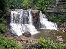
- Blackwater Falls and the Blackwater CanyonBlackwater CanyonBlackwater Canyon is a rugged, heavily-wooded, eight-mile long gorge carved by the Blackwater River in the Allegheny Mountains of eastern West Virginia, USA...
- Canaan ValleyCanaan ValleyCanaan Valley is an oval, bowl-like upland valley in northeastern Tucker County, West Virginia, USA. Within it are extensive wetlands and the headwaters of the Blackwater River which spills out of the valley at Blackwater Falls...
(surrounding mountains) - Cheat River GorgeCheat CanyonCheat Canyon — also called Cheat River Canyon or Cheat River Gorge — is a 10-mile long, forested canyon of the Cheat River at the western edge of the Allegheny Mountains in northeastern West Virginia, USA...
- Spruce KnobSpruce KnobSpruce Knob, at , is the highest point in the state of West Virginia and the summit of Spruce Mountain, the tallest mountain in the Alleghenies.-Overview:...