
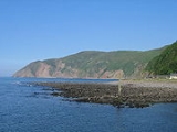
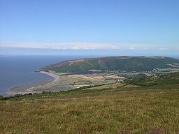
Porlock Bay
Encyclopedia
Bristol Channel
The Bristol Channel is a major inlet in the island of Great Britain, separating South Wales from Devon and Somerset in South West England. It extends from the lower estuary of the River Severn to the North Atlantic Ocean...
, between Hurlstone Point and Porlock Weir
Porlock Weir
Porlock Weir lies about 1.5 miles west of Porlock, Somerset, England and is a small settlement which has grown up around the harbour. It is a popular visitor attraction....
in Somerset
Somerset
The ceremonial and non-metropolitan county of Somerset in South West England borders Bristol and Gloucestershire to the north, Wiltshire to the east, Dorset to the south-east, and Devon to the south-west. It is partly bounded to the north and west by the Bristol Channel and the estuary of the...
, England.
The coastline includes shingle ridges, salt marshes and a submerged forest. In 1052 the Saxon king, Harold
Harold Godwinson
Harold Godwinson was the last Anglo-Saxon King of England.It could be argued that Edgar the Atheling, who was proclaimed as king by the witan but never crowned, was really the last Anglo-Saxon king...
, landed at Porlock Bay from Ireland
Ireland
Ireland is an island to the northwest of continental Europe. It is the third-largest island in Europe and the twentieth-largest island on Earth...
, and burnt the town before marching on London
London
London is the capital city of :England and the :United Kingdom, the largest metropolitan area in the United Kingdom, and the largest urban zone in the European Union by most measures. Located on the River Thames, London has been a major settlement for two millennia, its history going back to its...
.
Much of the coastline is under the care of the National Trust
National Trust for Places of Historic Interest or Natural Beauty
The National Trust for Places of Historic Interest or Natural Beauty, usually known as the National Trust, is a conservation organisation in England, Wales and Northern Ireland...
, and the coastline forms part of the South West Coast Path
South West Coast Path
The South West Coast Path is Britain's longest waymarked long-distance footpath and a National Trail. It stretches for , running from Minehead in Somerset, along the coasts of Devon and Cornwall, to Poole Harbour in Dorset. Since it rises and falls with every river mouth, it is also one of the more...
.
Porlock Ridge and Saltmarsh
Porlock Ridge and Saltmarsh is a 186.3 hectareHectare
The hectare is a metric unit of area defined as 10,000 square metres , and primarily used in the measurement of land. In 1795, when the metric system was introduced, the are was defined as being 100 square metres and the hectare was thus 100 ares or 1/100 km2...
(460.4 acre) biological Site of Special Scientific Interest on Porlock Bay, notified in 1990.
This site is notified for its nationally important active coastal geomorphological features. It is also nationally important for the salt marsh
Salt marsh
A salt marsh is an environment in the upper coastal intertidal zone between land and salt water or brackish water, it is dominated by dense stands of halophytic plants such as herbs, grasses, or low shrubs. These plants are terrestrial in origin and are essential to the stability of the salt marsh...
and coastal vegetated shingle
Shingle beach
A shingle beach is a beach which is armoured with pebbles or small- to medium-sized cobbles. Typically, the stone composition may grade from characteristic sizes ranging from two to 200 mm diameter....
habitats which occur here.
At Bossington a shingle beach, through which flows the River Horner
River Horner
The River Horner also known as Horner Water rises near Luccombe on Exmoor, Somerset, and flows past Porlock into Porlock Bay near Hurlstone Point on the Bristol Channel....
, rising sea levels in the 1990s caused the creation of salt marshes and lagoons developed in the area behind the boulder bank.
Geomorphological
This site comprises a shingle ridge and associated saltmarsh hinterland extending for a distance of approximately 4 kilometres along the west Somerset coast, immediately north of PorlockPorlock
Porlock is a coastal village and civil parish in Somerset, England, situated in a deep hollow below Exmoor, west of Minehead. The parish, which includes Hawkcombe and Doverhay, has a population of 1,377....
village. The type of geomorphological development seen at Porlock has been noted for coastal shingle systems elsewhere (e.g. west coast of Newfoundland, Canada
Canada
Canada is a North American country consisting of ten provinces and three territories. Located in the northern part of the continent, it extends from the Atlantic Ocean in the east to the Pacific Ocean in the west, and northward into the Arctic Ocean...
). Although other UK systems probably developed and are developing in a similar manner, Porlock provides the only fully documented example of a nationally important coastal geomorphological system which has undergone catastrophic failure and subsequent evolution following sediment
Sediment
Sediment is naturally occurring material that is broken down by processes of weathering and erosion, and is subsequently transported by the action of fluids such as wind, water, or ice, and/or by the force of gravity acting on the particle itself....
inhibition and a great storm in October 1996 which caused the single ridge to be breached allowing the marsh to be inundated with salt water at New Works (the drainage facilities for the previous managed fresh water marsh). This storm created a brand new tidal lagoon, which since that storm is rapidly developing with creeks forming and land that was recently farmed pasture now tidal salt marsh.
Biological
A large part of this site is lower saltmarsh dominated by common glasswort (Salicornia europaea andannual) and sea-blite (Suaeda maritima). Also found here is the nationally scarce Babington’s leekAllium ampeloprasum
Allium ampeloprasum is a member of the onion genus Allium. The wild plant is commonly known as Wild Leek - not to be confused with the N. American Allium tricoccum of the same name. Its native range is S. Europe to W...
Allium ampeloprasum ssp babingtonii. The site is visited regularly by grey heron
Grey Heron
The Grey Heron , is a wading bird of the heron family Ardeidae, native throughout temperate Europe and Asia and also parts of Africa. It is resident in the milder south and west, but many birds retreat in winter from the ice in colder regions...
(Ardea cinerea), little egret
Little Egret
The Little Egret is a small white heron. It is the Old World counterpart to the very similar New World Snowy Egret.-Subspecies:Depending on authority, two or three subspecies of Little Egret are currently accepted....
(Egretta garzetta) and shelduck
Common Shelduck
The Common Shelduck is a waterfowl species shelduck genus Tadorna. It is widespread and common in Eurasia, mainly breeding in temperate and wintering in subtropical regions; in winter, it can also be found in the Maghreb...
(Tadorna tadorna). Small winter flocks of lapwing
Northern Lapwing
The Northern Lapwing , also known as the Peewit, Green Plover or just Lapwing, is a bird in the plover family. It is common through temperate Eurasia....
(Vanellus vanellus), curlew
Eurasian Curlew
The Eurasian Curlew, Numenius arquata, is a wader in the large family Scolopacidae. It is one of the most widespread of the curlews, breeding across temperate Europe and Asia...
(Numenius arquata), and teal
Common Teal
The Eurasian Teal or Common Teal is a common and widespread duck which breeds in temperate Eurasia and migrates south in winter. The Eurasian Teal is often called simply the Teal due to being the only one of these small dabbling ducks in much of its range...
Anas crecca occur on the site as a whole. The site is also visited by a very wide range of migratory species.
Submerged forest
At low tide the remains of a submerged forestSubmerged forest
Submerged forest is a term used to describe the remains of trees which have been submerged by marine transgression, i.e. sea level rise and petrified. Examples can be found at low tide on the fringes of the submerged landmass known as Doggerland, around the coast of England and Wales, the Channel...
can be seen on Porlock Beach. The area was several miles inland until the sea level in the Bristol Channel rose about 7,000 to 8,000 years ago.