

Poppit Sands
Encyclopedia
Blue Flag beach
The Blue Flag is a certification by the Foundation for Environmental Education that a beach or marina meets its stringent standards.The Blue Flag is a trademark owned by FEE which is a not-for-profit, non-governmental organisation consisting of 65 organisations in 60 member countries in Europe,...
beach
Beach
A beach is a geological landform along the shoreline of an ocean, sea, lake or river. It usually consists of loose particles which are often composed of rock, such as sand, gravel, shingle, pebbles or cobblestones...
in northern Pembrokeshire
Pembrokeshire
Pembrokeshire is a county in the south west of Wales. It borders Carmarthenshire to the east and Ceredigion to the north east. The county town is Haverfordwest where Pembrokeshire County Council is headquartered....
, Wales
Wales
Wales is a country that is part of the United Kingdom and the island of Great Britain, bordered by England to its east and the Atlantic Ocean and Irish Sea to its west. It has a population of three million, and a total area of 20,779 km²...
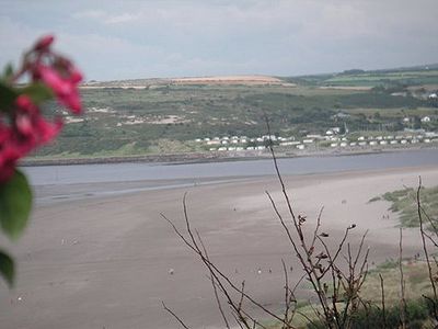
It lies on the estuary of the River Teifi
River Teifi
The River Teifi forms the boundary between the counties of Ceredigion and Carmarthenshire in south-west Wales for most of its 75 mile length, flowing into the sea below the town of Cardigan. The catchment of the river is estimated to be 1,008 square kilometres yielding an average flow at Glan...
near Cardigan
Cardigan, Ceredigion
Cardigan is a town in the county of Ceredigion in Mid Wales. It lies on the estuary of the River Teifi at the point where Ceredigion meets Pembrokeshire. It was the county town of the pre-1974 county of Cardiganshire. It is the second largest town in Ceredigion. The town's population was 4,203...
, and is adjacent to St. Dogmael's beach, at its eastern estuary end. The nearest village is St Dogmaels, and it offers views across the estuary and bay towards Gwbert
Gwbert
Gwbert , also known as Gwbert-on-Sea, is a small cliff top coastal hamlet in Y Ferwig community, Ceredigion, Wales. It lies at the most southerly coastal point of Ceredigion, on the eastern shore of the Teifi estuary, from where there are views westwards over Cardigan Bay, and south-westwards to...
and Cardigan Island
Cardigan Island
Cardigan Island is a small, uninhabited island lying north of Cardigan, in Ceredigion, south-west Wales. It reaches a height of 52 m a.s.l....
. Apart from the beach, it is also a small, dispersed settlement.
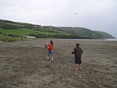
The beach
Backed by low dunes, the top of the beach comprises about 80m of dry, very loose sand, making it very popular with families. Lower down it is hard-packed. The beach slopes gently, and therefore the sea is shallow for quite a long way out. Even at high tide there is plenty of soft sand exposed.On the eastern side of the dunes, erosion has formed sand cliffs over 4 metres (13 feet) high. New dunes are now building up close to the access boardwalk.
When the tide is fully out, the flats at the far south-eastern end extend for nearly a mile and almost reach Gwbert on the other side. However, due to the estuary there are unpredictable currents at this end of the beach.
At the north-western end of the beach there are rock pools which support a myriad of sea-life.
The area is a gathering spot for surfers and boogie-boarders
Bodyboarding
Bodyboarding is a surface water sport . The average board consists of a small, rectangular piece of hydrodynamic foam, sometimes containing a ridged spine called a 'stringer'...
. As such, daily surf reports are issued. The hard sand below the high tide line also attracts power-kiting, land-boarding and buggying.
The beach is dog-friendly. Although some restrictions apply in the summer months, there is nevertheless a large area set aside for dog-walkers. The beach and the estuary flats are popular with dog-walkers all year round.
For fishermen the beach offers good catches of flounder
Flounder
The flounder is an ocean-dwelling flatfish species that is found in coastal lagoons and estuaries of the Northern Atlantic and Pacific Oceans.-Taxonomy:There are a number of geographical and taxonomical species to which flounder belong.*Western Atlantic...
, cod
Cod
Cod is the common name for genus Gadus, belonging to the family Gadidae, and is also used in the common name for various other fishes. Cod is a popular food with a mild flavor, low fat content and a dense, flaky white flesh. Cod livers are processed to make cod liver oil, an important source of...
and whiting
Whiting
Whiting is the name of several species of fish:*Merlangius merlangus, the original species to receive the name; a common food fish of the cod family found in the northeastern Atlantic Ocean around Europe and the Mediterranean regions...
in winter, and mullet
Mullet
- Fish :* Mullet , or "grey mullets", of the family Mugilidae, of which the most widely known species is the striped mullet, Mugil cephalus* Goatfish, or "red mullets", of the family Mullidae; in particular, red mullets of the genus Mullus...
can be caught near the river mouth. Salmon
Salmon
Salmon is the common name for several species of fish in the family Salmonidae. Several other fish in the same family are called trout; the difference is often said to be that salmon migrate and trout are resident, but this distinction does not strictly hold true...
and sea trout run the river from March to October (an Environment Agency rod licence is necessary if trying for sea trout on the incoming tide).
Local photographer Michael Jackson spent a considerable amount of time between 2007 and 2011 photographing Poppit Sands beach, from above and at dusk. His work won numerous awards, including 3 Hasselblad Masters
Hasselblad Award
The Hasselblad Foundation International Award in Photography is an award granted to "a photographer recognized for major achievements".The award – and the foundation – was set up from the estate of Erna and Victor Hasselblad...
Finalist places (in 2008, 2009 & 2010). The work has been exhibited in the UK, Hong Kong, Copenhagen and New York , and has also been published in a book entitled "Poppit Sands Moonscapes".
Beach safety
The beach has Blue Flag status. Lifeguards patrol the beach from late June to early September, from 10.00 - 6.00 each day, and bathing is safe within the patrolled area, marked by flags.Water users are advised not to swim in the estuary to the south due to fast currents, but rather to stay at the main beach.
There is a Poppit Sands Surf Lifesaving Club. In June 2011 it was announced that the Club had been awarded £35,980 from the Big Lottery Fund
Big Lottery Fund
The Big Lottery Fund is a grant-making non-departmental public body in the United Kingdom created by the Government to administer the funding of "good causes" following the creation of the National Lottery. It has an annual expenditure of £630 million...
, for use on new equipment and to provide additional opportunities for recruiting new members.
Lifeboat station
An RNLI lifeboat station, housing two inshore lifeboats, also operates from the beach, and the lifeboat crew have training sessions twice a week - on Sunday mornings and Wednesday evenings. A station was first opened at Poppit Sands in 1971, the previous station (on the south side of the River Teifi below Penrhyn Castle) having closed in 1932. In 1987 a new boathouse, built for the new C class lifeboat, was officially opened. Then in 1998 a new double boathouse was completed for a B class and D class lifeboats, for launching vehicles, and it also provided improved crew facilities. The station is known as RNLI Lifeboat Station : Cardigan, and the crews have been presented with 15 awards for gallantry.The station also houses an RNLI shop, open throughout the year, volunteers permitting.
Facilities and access
Poppit Sands lies at the northern end of the Pembrokeshire Coast PathPembrokeshire Coast Path
The Pembrokeshire Coast Path is a National Trail in southwest Wales. It was established in 1970, and is 186 miles long, mostly at cliff-top level, with 35,000 feet of ascent and descent. The northern end is at Poppit Sands, near St...
, an 180 mile long-distance walk. There is a large pay car-park, with adjacent public toilets.
The cafe and shop, located by the car park, has been recently refurbished, and also sells beach items like beach balls, inflatables, buckets and spades, and a limited range of body boards and wetsuits.
The main beach is accessed from a boardwalk, and is suitable for disabled access.
Poppit Sands gives its name to "The Poppit Rocket", a local bus service which largely follows the coast between Cardigan
Cardigan
Cardigan may refer to:In geography:* Cardigan, Prince Edward Island, Canada* Cardigan , an electoral district in Prince Edward Island* Mount Cardigan, a mountain in New Hampshire, U.S.* Cardigan, Ceredigion, Wales...
and Fishguard
Fishguard
Fishguard is a coastal town in Pembrokeshire, south-west Wales, with a population of 3,300 . The community of Fishguard and Goodwick had a population of 5043 at the 2001 census....
, and which calls at the beach here.
Poppit Sands Youth Hostel, a former inn, is up the lane towards Cemaes Head, has views over the estuary and bay.
Camping, with hard-standing for camper-vans, is available at Poppit Sands.
Wildlife & plant life
The dunes at Poppit Sands are important for wildlife, especially rare plants such as the bee orchidBee Orchid
The Bee Orchid is an herbaceous perennial plant belonging to the family Orchidaceae.-Etymology:The name "Ophrys" derives from the Greek word "ophrys", meaning "eyebrow", while the Latin name of the species "apifera" refers to the bee-shaped lip.-Description: The Bee Orchid grows to a height of ....
. National Park staff manage over 20 hectares (50 acres) of dune, marsh and grazing land here, and one of its projects is to turn the willow
Willow
Willows, sallows, and osiers form the genus Salix, around 400 species of deciduous trees and shrubs, found primarily on moist soils in cold and temperate regions of the Northern Hemisphere...
scrub behind the dunes back to a reed bed
Reed bed
Reed beds are natural habitats found in floodplains, waterlogged depressions andestuaries. Reed beds are part of a succession from young reed colonising open water or wet ground through a gradation of increasingly dry ground...
.
In the summer months it is often possible to observe Bottlenose Dolphin
Bottlenose Dolphin
Bottlenose dolphins, the genus Tursiops, are the most common and well-known members of the family Delphinidae, the family of oceanic dolphins. Recent molecular studies show the genus contains two species, the common bottlenose dolphin and the Indo-Pacific bottlenose dolphin , instead of one...
s, porpoises and Atlantic Grey Seals in this part of Cardigan Bay. Occasional boat trips around the bay, with wildlife spotting their main aim, leave from Poppit sands during the summer months.
Geology
The rocks of the area are mostly mudstoneMudstone
Mudstone is a fine grained sedimentary rock whose original constituents were clays or muds. Grain size is up to 0.0625 mm with individual grains too small to be distinguished without a microscope. With increased pressure over time the platey clay minerals may become aligned, with the...
, deposited in a deep ocean basin some 450 million years ago. Very few fossils are found in the rocks because the sediments were deposited in such deep water. Associated locally with the mudstone are beds of hard sandstone
Sandstone
Sandstone is a sedimentary rock composed mainly of sand-sized minerals or rock grains.Most sandstone is composed of quartz and/or feldspar because these are the most common minerals in the Earth's crust. Like sand, sandstone may be any colour, but the most common colours are tan, brown, yellow,...
(turbidites); at Poppit Sands these beds are up to a metre or two thick. Deposited as muds and sands on the ocean floor, they were subsequently squeezed and folded by major earth movements, which changed the mudstones into slates. Excellent examples of these folded rocks can be seen at the western end of Poppit Sands.
Climate
As with the rest of the British IslesBritish Isles
The British Isles are a group of islands off the northwest coast of continental Europe that include the islands of Great Britain and Ireland and over six thousand smaller isles. There are two sovereign states located on the islands: the United Kingdom of Great Britain and Northern Ireland and...
, Poppit Sands experiences a maritime climate with cool summers and mild winters. The nearest official Met Office
Met Office
The Met Office , is the United Kingdom's national weather service, and a trading fund of the Department for Business, Innovation and Skills...
weather station
Weather station
A weather station is a facility, either on land or sea, with instruments and equipment for observing atmospheric conditions to provide information for weather forecasts and to study the weather and climate. The measurements taken include temperature, barometric pressure, humidity, wind speed, wind...
for which online records are available is at Aberporth
Aberporth
Aberporth is a community and small town in Ceredigion on the west coast of Wales. The population was 2,485 in 2001.- Location :The town lies at the southern end of Cardigan Bay about six miles north of Cardigan and ten miles south of New Quay approximately one mile west of the A487, on the...
, which is 6.5 miles (10.7 km) ENE of Poppit Sands, and has a similar coastal aspect.
Typically, less than 3 days of the year will reach 25.1 °C (77.2 °F) of above, the warmest of which should rise to 26.8 °C (80.2 °F) - The highest temperature recorded was 32.7 °C (90.9 °F), during July 2006.
On average 18.3 nights will report air frost and the coldest night of the year should fall to -4.5 C. The lowest recorded temperature was -9.9 C, during January 1963.
Rainfall averages around 870mm a year, with at least 1mm falling on 143.5 days.
A detailed daily weather forecast for the area, including sea temperature, can be found here.
Etymology
Despite the wealth of travel literature and gazetteers which prevailed in the 19th century, and which include information on nearby Cardigan, the growing resort of Gwbert (across the estuary), and the Abbey at St. Dogmaels, they fail to record any beach here, and it seems it did not become known as a resort until later in the 20th century.The earliest published reference to the name "Poppit" appears to be in Archaeologia Cambrensis by W. Pickering, 1902, where there is a reference to "the main road to Poppit".
The name "Poppit", however, can be traced back to the 16th century, and is found in documents relating to the Dissolution of the Monasteries
Dissolution of the Monasteries
The Dissolution of the Monasteries, sometimes referred to as the Suppression of the Monasteries, was the set of administrative and legal processes between 1536 and 1541 by which Henry VIII disbanded monasteries, priories, convents and friaries in England, Wales and Ireland; appropriated their...
, in particular with regard to lands owned by nearby St. Dogmael's Abbey. A document of 1537 records :
- "One close called Potpitt containing 15 acres adjacent to the seashore - 6s.8d."
A later Patent Roll of 1544 records :
- "Charter of John Bradshaw to him and his heirs .... Also all that our close called Potpyt containing by estimation fifteen acres adjacent to the seashore."
In "The History of St. Dogmaels Abbey", by Emily M. Pritchard, 1907, it states :
- "Among the particulars for grants, dated March 1537, is the preliminary account of the Manor and property of the Abbey of St. Dogmaels .... . These [Abbey] deeds should be specially interesting to the present inhabitants of St Dogmaels, owing to the family names, which are still mostly the same, and also the place names of various portions of land, lately belonging to the Abbey. Among these, Potpitt , now Poppitt , formerly the name for 'Pwll-cam' (the crooked pool)."
- "It is between this Manaian Marsh and the sea that this Poppit lays, mentioned as Potpitt in one of the Abbey grants ; the sands also on the same side of the river are called the Poppit Sands."
External links
- Poppit Sands - Cardiganshire Coast Official website
- Poppit Sands Cafe & Shop
- Poppit Sands Daily Surf Report
- Poppet Sands Surf Lifesaving Club
- Tide Times for Poppit Sands (Cardigan)