

Iowa Highway 415
Encyclopedia
Iowa Highway 415 is a short state highway
that runs mostly north-to-south in central Iowa
. Iowa 415 begins at U.S. Route 6
in Des Moines and ends at Iowa Highway 141
east of Granger
. Prior to 2003, Iowa 415 extended north from Polk City
and ended at Iowa Highway 17 south of Madrid
. Now, Iowa 415 turns west at Polk City
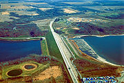
and crosses the Des Moines River
at Saylorville Lake
prior to ending at Iowa 141. Since the rerouting in 2003, the northern terminus for Iowa 415 is now farther south than its northernmost point in Polk City
.
. Iowa 415 heads north along Second Avenue through Des Moines' Highland Park neighborhood. It exits Des Moines and enters Saylor Township, where it passes a Firestone Tire and Rubber Company
factory and intersects Interstate 35 / Interstate 80. Iowa 415 continues north as a four-lane divided highway
and passes the Margo Frankel Woods State Park. Just east of Saylorville
, Iowa 415 intersects NE 66 Avenue at a diamond interchange
.
 On the southern edge of Ankeny
, Iowa 415 turns west at the intersection of State Street and Oralabor Road, which is also the western end of Iowa Highway 160
. The highway goes west for 2 miles (3.2 km) before turning to the north and reaching the access road to the Saylorville Lake
causeway. Iowa 415 stays about one mile (1.6 km) east and north of Saylorville Lake coast, following the general northwest angle of the lake. Along the northern coast of the lake, Iowa 415 provides marina and beach access for those seeking recreation.
At Polk City
, Iowa 415 turns to the west along West Bridge Road, which becomes NW 112 Avenue as it leaves Polk City and turns to the southwest. NW 112 Avenue crosses Saylorville Lake over the Mile Long Bridge. Northbound Iowa 415, heading southwest, intersects NW Beaver Drive just west of the western coast. It continues south and west for 1+1/2 mi where it ends at a trumpet interchange with Iowa Highway 141
in Jefferson Township, east of Granger
.
from Des Moines
to Polk City
. It was created from an abandoned segment of Iowa Highway 60
, which had been relocated to the west. In the early 1980s, it was extended north from Polk City to 2 miles (3.2 km) south of Madrid
, on Iowa Highway 17. This route stayed the same until 2003 when it was rerouted from Polk City across Saylorville Lake
to a new interchange at Iowa Highway 141
.
Highway
A highway is any public road. In American English, the term is common and almost always designates major roads. In British English, the term designates any road open to the public. Any interconnected set of highways can be variously referred to as a "highway system", a "highway network", or a...
that runs mostly north-to-south in central Iowa
Iowa
Iowa is a state located in the Midwestern United States, an area often referred to as the "American Heartland". It derives its name from the Ioway people, one of the many American Indian tribes that occupied the state at the time of European exploration. Iowa was a part of the French colony of New...
. Iowa 415 begins at U.S. Route 6
U.S. Route 6 in Iowa
U.S. Route 6 is an east–west U.S. highway which runs across the U.S. state of Iowa. It is signed in places as the Grand Army of the Republic Highway. Like all state highways in Iowa, it is maintained by the Iowa Department of Transportation. The route begins at the Missouri River...
in Des Moines and ends at Iowa Highway 141
Iowa Highway 141
Iowa Highway 141 is a major east–west highway in the western and central portions of the state. It is the most direct link between Sioux City and Des Moines. It also serves as a freeway link between Des Moines and the outlying communities of Perry, Granger, and Grimes. Iowa 141's western...
east of Granger
Granger, Iowa
As of the census of 2000, there were 583 people, 245 households, and 150 families residing in the city. The population density was 1,136.6 people per square mile . There were 265 housing units at an average density of 516.6 per square mile . The racial makeup of the city was 98.63% White, 0.17%...
. Prior to 2003, Iowa 415 extended north from Polk City
Polk City, Iowa
As of the census of 2000, there were 2,344 people, 826 households, and 645 families residing in the city. The population density was 862.4 people per square mile . There were 842 housing units at an average density of 309.8 per square mile...
and ended at Iowa Highway 17 south of Madrid
Madrid, Iowa
Madrid is a city in Douglas Township, Boone County, Iowa, United States. The population was 2,264 at the 2000 census. It is part of the 'Boone, Iowa Micropolitan Statistical Area', which is a part of the larger 'Ames-Boone, Iowa Combined Statistical Area'....
. Now, Iowa 415 turns west at Polk City
Polk City, Iowa
As of the census of 2000, there were 2,344 people, 826 households, and 645 families residing in the city. The population density was 862.4 people per square mile . There were 842 housing units at an average density of 309.8 per square mile...
and crosses the Des Moines River
Des Moines River
The Des Moines River is a tributary river of the Mississippi River, approximately long to its farther headwaters, in the upper Midwestern United States...
at Saylorville Lake
Saylorville Lake
Saylorville Lake is a reservoir on the Des Moines River in Iowa. It is located upstream from the city of Des Moines, and from the mouth of the Des Moines River at the Mississippi River...
prior to ending at Iowa 141. Since the rerouting in 2003, the northern terminus for Iowa 415 is now farther south than its northernmost point in Polk City
Polk City, Iowa
As of the census of 2000, there were 2,344 people, 826 households, and 645 families residing in the city. The population density was 862.4 people per square mile . There were 842 housing units at an average density of 309.8 per square mile...
.
Route description
Iowa Highway 415 begins at an intersection with U.S. Route 6, which runs along Euclid Avenue, in Des MoinesDes Moines, Iowa
Des Moines is the capital and the most populous city in the US state of Iowa. It is also the county seat of Polk County. A small portion of the city extends into Warren County. It was incorporated on September 22, 1851, as Fort Des Moines which was shortened to "Des Moines" in 1857...
. Iowa 415 heads north along Second Avenue through Des Moines' Highland Park neighborhood. It exits Des Moines and enters Saylor Township, where it passes a Firestone Tire and Rubber Company
Firestone Tire and Rubber Company
The Firestone Tire and Rubber Company is an American tire company founded by Harvey Firestone in 1900 to supply pneumatic tires for wagons, buggies, and other forms of wheeled transportation common in the era. Firestone soon saw the huge potential for marketing tires for automobiles. The company...
factory and intersects Interstate 35 / Interstate 80. Iowa 415 continues north as a four-lane divided highway
Divided Highway
Divided Highway is a compilation album by American rock band The Doobie Brothers, released in 2003. . All tracks are taken from the albums Cycles and Brotherhood .-Track listing:...
and passes the Margo Frankel Woods State Park. Just east of Saylorville
Saylorville, Iowa
Saylorville is a census-designated place in Polk County, Iowa, United States. The population was 3,238 at the 2000 census. It is part of the Des Moines–West Des Moines Metropolitan Statistical Area. The Saydel Community School District is located in this area...
, Iowa 415 intersects NE 66 Avenue at a diamond interchange
Diamond interchange
A diamond interchange is a common type of road junction, used where a freeway crosses a minor road. The freeway itself is grade-separated from the minor road, one crossing the other over a bridge...
.
Ankeny, Iowa
Ankeny is a city in Polk County, Iowa, United States. The population was 45,562 in the 2010 census, an increase of 68% from the 27,117 population in the 2000 census. It is part of the Des Moines–West Des Moines Metropolitan Statistical Area.-History:...
, Iowa 415 turns west at the intersection of State Street and Oralabor Road, which is also the western end of Iowa Highway 160
Iowa Highway 160
Iowa Highway 160 is a short state highway that runs from west to east in central Iowa. Its western terminus is at Iowa Highway 415 in Ankeny. Its eastern terminus is at Exit 90 of Interstate 35 in Ankeny. Originally ending at a Y intersection, south of the current intersection with IA 415, the...
. The highway goes west for 2 miles (3.2 km) before turning to the north and reaching the access road to the Saylorville Lake
Saylorville Lake
Saylorville Lake is a reservoir on the Des Moines River in Iowa. It is located upstream from the city of Des Moines, and from the mouth of the Des Moines River at the Mississippi River...
causeway. Iowa 415 stays about one mile (1.6 km) east and north of Saylorville Lake coast, following the general northwest angle of the lake. Along the northern coast of the lake, Iowa 415 provides marina and beach access for those seeking recreation.
At Polk City
Polk City, Iowa
As of the census of 2000, there were 2,344 people, 826 households, and 645 families residing in the city. The population density was 862.4 people per square mile . There were 842 housing units at an average density of 309.8 per square mile...
, Iowa 415 turns to the west along West Bridge Road, which becomes NW 112 Avenue as it leaves Polk City and turns to the southwest. NW 112 Avenue crosses Saylorville Lake over the Mile Long Bridge. Northbound Iowa 415, heading southwest, intersects NW Beaver Drive just west of the western coast. It continues south and west for 1+1/2 mi where it ends at a trumpet interchange with Iowa Highway 141
Iowa Highway 141
Iowa Highway 141 is a major east–west highway in the western and central portions of the state. It is the most direct link between Sioux City and Des Moines. It also serves as a freeway link between Des Moines and the outlying communities of Perry, Granger, and Grimes. Iowa 141's western...
in Jefferson Township, east of Granger
Granger, Iowa
As of the census of 2000, there were 583 people, 245 households, and 150 families residing in the city. The population density was 1,136.6 people per square mile . There were 265 housing units at an average density of 516.6 per square mile . The racial makeup of the city was 98.63% White, 0.17%...
.
History
Iowa Highway 415 was designated in 1959, first appearing on state maps in 1960, as a spur routeSpur route
A spur route is a short road forming a branch from a longer, more important route . A bypass or beltway is never considered a true spur route as it typically reconnects with the major road...
from Des Moines
Des Moines, Iowa
Des Moines is the capital and the most populous city in the US state of Iowa. It is also the county seat of Polk County. A small portion of the city extends into Warren County. It was incorporated on September 22, 1851, as Fort Des Moines which was shortened to "Des Moines" in 1857...
to Polk City
Polk City, Iowa
As of the census of 2000, there were 2,344 people, 826 households, and 645 families residing in the city. The population density was 862.4 people per square mile . There were 842 housing units at an average density of 309.8 per square mile...
. It was created from an abandoned segment of Iowa Highway 60
Iowa Highway 60 (former)
Iowa Highway 60, or Iowa 60, is a route in northwestern Iowa.The former Iowa Highway 60 may refer to these routes:* Iowa Highway 5, the route from Missouri Route 5 to Interstate 35 at West Des Moines.* Iowa Highway 415, the route from U.S...
, which had been relocated to the west. In the early 1980s, it was extended north from Polk City to 2 miles (3.2 km) south of Madrid
Madrid, Iowa
Madrid is a city in Douglas Township, Boone County, Iowa, United States. The population was 2,264 at the 2000 census. It is part of the 'Boone, Iowa Micropolitan Statistical Area', which is a part of the larger 'Ames-Boone, Iowa Combined Statistical Area'....
, on Iowa Highway 17. This route stayed the same until 2003 when it was rerouted from Polk City across Saylorville Lake
Saylorville Lake
Saylorville Lake is a reservoir on the Des Moines River in Iowa. It is located upstream from the city of Des Moines, and from the mouth of the Des Moines River at the Mississippi River...
to a new interchange at Iowa Highway 141
Iowa Highway 141
Iowa Highway 141 is a major east–west highway in the western and central portions of the state. It is the most direct link between Sioux City and Des Moines. It also serves as a freeway link between Des Moines and the outlying communities of Perry, Granger, and Grimes. Iowa 141's western...
.