
Point Conception Light
Encyclopedia
Point Conception Light is a lighthouse
on Point Conception
at the west entrance of the Santa Barbara Channel
, California
. It is one of the earliest California lighthouses and is listed on the National Register of Historic Places
.
 Juan Rodríguez Cabrillo
sailed along the California coast in search for glory and gold. On October 18, 1542, he encountered heavy winds upon rounding the Point and was forced to turn back to San Miguel Island where he died. Second-in-command Bartolomé Ferrelo
took charge and again tried to round the Point but he was also unsuccessful.
The Point was named Punta de la Limpia Concepcion by Sebastián Vizcaíno
in 1602, who was the next Spanish sailor to venture the Pacific waters along the California coast after Juan Cabrillo. The 1835 experience of the sailing ship Pilgrim, which was damaged and nearly capsized in a sudden change of weather here, is typical of boaters even today.
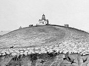
It was here at Point Conception in 1856, that the lighthouse was built high on the sandstone cliffs, above the location of the present lighthouse. The lens and steel tower for the lighthouse were made in France at a cost of $65,068 and was transported around Cape Horn
. A report indicates that the lighthouse was severely damaged during the Fort Tejon earthquake
of January 9, 1857.
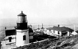
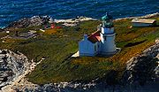 The lighthouse was moved in 1881 because the fog would be less likely to obscure the light, and was rebuilt from the top of the bluff
to a mesa
halfway down, 133 feet (40.5 m) above the Pacific Ocean
. The light station was automated by the United States Coast Guard
in 1973.
In recent years Vandenberg Air Force Base
restricts access from the northwest, and a private ranch restricts access from the adjoining land although a few people have reached the lighthouse by hiking west along the narrow rugged public beach several miles from the nearest road during low tide. Some have also arranged well in advance with the Coast Guard for access.
Lighthouse
A lighthouse is a tower, building, or other type of structure designed to emit light from a system of lamps and lenses or, in older times, from a fire, and used as an aid to navigation for maritime pilots at sea or on inland waterways....
on Point Conception
Point Conception
Point Conception is a headland along the Pacific coast of U.S. state of California, located in southwestern Santa Barbara County. It is the point where the Santa Barbara Channel meets the Pacific Ocean, and as the corner between the mostly north-south trending portion of coast to the north and the...
at the west entrance of the Santa Barbara Channel
Santa Barbara Channel
The Santa Barbara Channel is a portion of the Pacific Ocean which separates the mainland of California from the northern Channel Islands. It is generally south of the city of Santa Barbara, and west of the city of Ventura....
, California
California
California is a state located on the West Coast of the United States. It is by far the most populous U.S. state, and the third-largest by land area...
. It is one of the earliest California lighthouses and is listed on the National Register of Historic Places
National Register of Historic Places
The National Register of Historic Places is the United States government's official list of districts, sites, buildings, structures, and objects deemed worthy of preservation...
.
History
Juan Rodríguez Cabrillo
Juan Rodriguez Cabrillo was a Portuguese explorer noted for his exploration of the west coast of North America on behalf of Spain. Cabrillo was the first European explorer to navigate the coast of present day California in the United States...
sailed along the California coast in search for glory and gold. On October 18, 1542, he encountered heavy winds upon rounding the Point and was forced to turn back to San Miguel Island where he died. Second-in-command Bartolomé Ferrelo
Bartolomé Ferrelo
Bartolomé Ferrelo, also known as Bartolomé Ferrer, born 1499 in Bilbao Spain, died 1550 in Mexico.He was the pilot for Juan Rodrigo Cabrillo, the Portuguese captain who was sent by the viceroy of Mexico, with two ships in 1542 to explore what is now Northern California...
took charge and again tried to round the Point but he was also unsuccessful.
The Point was named Punta de la Limpia Concepcion by Sebastián Vizcaíno
Sebastián Vizcaíno
Sebastián Vizcaíno was a Spanish soldier, entrepreneur, explorer, and diplomat whose varied roles took him to New Spain, the Philippines, the Baja California peninsula, the California coast and Japan.-Early career:...
in 1602, who was the next Spanish sailor to venture the Pacific waters along the California coast after Juan Cabrillo. The 1835 experience of the sailing ship Pilgrim, which was damaged and nearly capsized in a sudden change of weather here, is typical of boaters even today.
It was here at Point Conception in 1856, that the lighthouse was built high on the sandstone cliffs, above the location of the present lighthouse. The lens and steel tower for the lighthouse were made in France at a cost of $65,068 and was transported around Cape Horn
Cape Horn
Cape Horn is the southernmost headland of the Tierra del Fuego archipelago of southern Chile, and is located on the small Hornos Island...
. A report indicates that the lighthouse was severely damaged during the Fort Tejon earthquake
Fort Tejon earthquake
The Fort Tejon earthquake occurred at about 8:20 AM on January 9, 1857. It ruptured the San Andreas Fault for a length of about 225 miles , between Parkfield and Wrightwood. The average slip along the fault was 4.5 meters , and a maximum offset of 9 meters was recorded in the Carrizo Plain area...
of January 9, 1857.
Hill
A hill is a landform that extends above the surrounding terrain. Hills often have a distinct summit, although in areas with scarp/dip topography a hill may refer to a particular section of flat terrain without a massive summit A hill is a landform that extends above the surrounding terrain. Hills...
to a mesa
Mesa
A mesa or table mountain is an elevated area of land with a flat top and sides that are usually steep cliffs. It takes its name from its characteristic table-top shape....
halfway down, 133 feet (40.5 m) above the Pacific Ocean
Pacific Ocean
The Pacific Ocean is the largest of the Earth's oceanic divisions. It extends from the Arctic in the north to the Southern Ocean in the south, bounded by Asia and Australia in the west, and the Americas in the east.At 165.2 million square kilometres in area, this largest division of the World...
. The light station was automated by the United States Coast Guard
United States Coast Guard
The United States Coast Guard is a branch of the United States Armed Forces and one of the seven U.S. uniformed services. The Coast Guard is a maritime, military, multi-mission service unique among the military branches for having a maritime law enforcement mission and a federal regulatory agency...
in 1973.
In recent years Vandenberg Air Force Base
Vandenberg Air Force Base
Vandenberg Air Force Base is a United States Air Force Base, located approximately northwest of Lompoc, California. It is under the jurisdiction of the 30th Space Wing, Air Force Space Command ....
restricts access from the northwest, and a private ranch restricts access from the adjoining land although a few people have reached the lighthouse by hiking west along the narrow rugged public beach several miles from the nearest road during low tide. Some have also arranged well in advance with the Coast Guard for access.
See also
- Point ConceptionPoint ConceptionPoint Conception is a headland along the Pacific coast of U.S. state of California, located in southwestern Santa Barbara County. It is the point where the Santa Barbara Channel meets the Pacific Ocean, and as the corner between the mostly north-south trending portion of coast to the north and the...
- Point Arguello LightPoint Arguello LightPoint Arguello Lighthouse is a lighthouse on Point Arguello, serving the Santa Barbara Channel, California adjoining Vandenberg Air Force Base near the city of Lompoc, California....
- Vandenberg Air Force BaseVandenberg Air Force BaseVandenberg Air Force Base is a United States Air Force Base, located approximately northwest of Lompoc, California. It is under the jurisdiction of the 30th Space Wing, Air Force Space Command ....
- Channel Islands National Marine SanctuaryChannel Islands National Marine SanctuaryThe Channel Islands National Marine Sanctuary is a reserve area off the Pacific coast of the United States, near California.Established in 1980, the sanctuary in the Santa Barbara Channel is an area of national significance because of its exceptional natural beauty and resources. It has an area of...
- Channel Islands of CaliforniaChannel Islands of CaliforniaThe Channel Islands of California are a chain of eight islands located in the Pacific Ocean off the coast of Southern California along the Santa Barbara Channel in the United States of America...