
Point Arguello Light
Encyclopedia
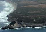
Point Arguello Lighthouse is a lighthouse
on Point Arguello
, serving the Santa Barbara Channel
, California
adjoining Vandenberg Air Force Base
near the city of Lompoc, California
.
The original Point Arguello lighthouse, built in 1901, had a white square cylindrical tower attached to a one story keeper's house. It had a fourth order Fresnel lens
, which was transferred from the Point Hueneme Light
house. The tower was replaced in 1934 by a square pyramidal skeletal steel
tower, which was in turn replaced by the current post light.
Indian' name "Nocto" and was part of the territory ruled by Chief Salipuata at the time of the occupation by the Spanish missionaries
. The Native American
s were part of the third indigenous people in the area, the Canalino branch of the Chumash people. In Paleo-indian times, a people of Mongolian heritage first settled along the Southern California
coast in areas where oak trees
were plentiful, from which characteristic they have been named "The Oak Tree (Grove) People". They vanished some hundreds of years B.C.E., and after a period without archaeological evidence, a second semi—nomadic group arrived. These "hunting people" gradually merged with a third group, the Chumash people, as they settled here.
On August 28, 1769, the Portola expedition
camped near Point Arguello, where they found a small Chumash rancheria
. This area had many excellent flint
s, and so they named it Los Pederales, The Flints. This name continued to be used for the point on Spanish maps until Mexican Independence
in 1821. The American and non-Spanish European designation was Point Arguello, from the name given by George Vancouver
in 1793, in honor of José Darío Argüello
, then Commandant of the Presidio of Monterey.
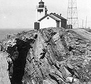
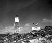 In 1901, the lighthouse service built the first light station at Point Arguello. Due to erosion, The tower was replaced in 1911 with a standalone tower. Between 1934 and 1938, increased in coastwise shipping necessitated the service establish a lifeboat station.http://www.lighthousefriends.com/light.asp?ID=645.com/light.asp?ID=645 In 1934, the tower was razed and replaced with a skeleton tower.
On July 1, 1939, the Lighthouse Service was combined with the Coast Guard to augment the Service by 8,000 men who took their place in forming a nucleus for our present day light stations and aids to navigation work. During the interim of World War II, the Coast Guard manned Point Arguello Light and Point Arguello Lifeboat station, as well as a newly established LORAN Station. After 12 years-operation following the War, it was deemed economical to disestablish the lifeboat station and so in 1958, Point Arguello Lifeboat Station was retired.
Point Arguello had, until 1967, an allowance of 12 enlisted personnel and accommodations for eight families.
In 1923 what has been called the U.S. Navy’s greatest peacetime disaster, the Honda Point Disaster
, occurred off the Point when seven 4—stacker destroyer
s mistook Point Arguello for Point Conception
and sank, with 22 sailors lost. Mariners say that the chief reason that so many boats have struck there is that in bad weather typical of that shoreline, sailing a boat into the channel between San Miguel Island and Points Arguello and Conception is like sailing into the eye of a needle.
facilities in North America, at Vandenberg Air Force Base
where many other rocket launch sites have been built since the start of the Space Age
.
. The weather station disseminates information upon which conditions for the western portion of the Santa Barbara Channel
are based. Facilities at the light include a 36-inch revolving beacon of 1,100,000 candle power that can be seen approximately 17 miles (27.4 km) at sea. The light itself is 124 feet (37.8 m) above the water. A two-tone diaphone fog signal is placed in operation when visibility is less than five miles (8 km). The diaphone when operating is synchronized with a radio beacon every three minutes for distance finding.
Lighthouse
A lighthouse is a tower, building, or other type of structure designed to emit light from a system of lamps and lenses or, in older times, from a fire, and used as an aid to navigation for maritime pilots at sea or on inland waterways....
on Point Arguello
Point Arguello
Point Arguello is a headland used as a launch site by the United States Navy. Point Arguello was first used in 1959 for the launch of military and sounding rockets. It was transferred to the United States Air Force in 1964, at which time it became part of Vandenberg Air Force Base.There were 6...
, serving the Santa Barbara Channel
Santa Barbara Channel
The Santa Barbara Channel is a portion of the Pacific Ocean which separates the mainland of California from the northern Channel Islands. It is generally south of the city of Santa Barbara, and west of the city of Ventura....
, California
California
California is a state located on the West Coast of the United States. It is by far the most populous U.S. state, and the third-largest by land area...
adjoining Vandenberg Air Force Base
Vandenberg Air Force Base
Vandenberg Air Force Base is a United States Air Force Base, located approximately northwest of Lompoc, California. It is under the jurisdiction of the 30th Space Wing, Air Force Space Command ....
near the city of Lompoc, California
Lompoc, California
Lompoc is a city in Santa Barbara County, California, United States. The city was incorporated in 1888. The population was 42,434 at the 2010 census, up from 41,103 at the 2000 census....
.
The original Point Arguello lighthouse, built in 1901, had a white square cylindrical tower attached to a one story keeper's house. It had a fourth order Fresnel lens
Fresnel lens
A Fresnel lens is a type of lens originally developed by French physicist Augustin-Jean Fresnel for lighthouses.The design allows the construction of lenses of large aperture and short focal length without the mass and volume of material that would be required by a lens of conventional design...
, which was transferred from the Point Hueneme Light
Point Hueneme Light
Point Hueneme Lighthouse is a lighthouse on the southeast entrance to the Santa Barbara Channel, in Ventura County, California-History:thumb|left|Original 1874 Lighthouse, [[USCG]] photo...
house. The tower was replaced in 1934 by a square pyramidal skeletal steel
Steel
Steel is an alloy that consists mostly of iron and has a carbon content between 0.2% and 2.1% by weight, depending on the grade. Carbon is the most common alloying material for iron, but various other alloying elements are used, such as manganese, chromium, vanadium, and tungsten...
tower, which was in turn replaced by the current post light.
Point Arguello
The area of land now known as Point Arguello was originally known by the 'Chumashan—CanalinoChumashan languages
Chumashan is a family of languages that were spoken on the southern California coast by Native American Chumash people.From the Coastal plains and valleys of San Luis Obispo to Malibu), neighboring inland and Transverse Ranges valleys and canyons east to bordering the San Joaquin Valley; and on...
Indian' name "Nocto" and was part of the territory ruled by Chief Salipuata at the time of the occupation by the Spanish missionaries
Spanish colonization of the Americas
Colonial expansion under the Spanish Empire was initiated by the Spanish conquistadores and developed by the Monarchy of Spain through its administrators and missionaries. The motivations for colonial expansion were trade and the spread of the Christian faith through indigenous conversions...
. The Native American
Native Americans in the United States
Native Americans in the United States are the indigenous peoples in North America within the boundaries of the present-day continental United States, parts of Alaska, and the island state of Hawaii. They are composed of numerous, distinct tribes, states, and ethnic groups, many of which survive as...
s were part of the third indigenous people in the area, the Canalino branch of the Chumash people. In Paleo-indian times, a people of Mongolian heritage first settled along the Southern California
Southern California
Southern California is a megaregion, or megapolitan area, in the southern area of the U.S. state of California. Large urban areas include Greater Los Angeles and Greater San Diego. The urban area stretches along the coast from Ventura through the Southland and Inland Empire to San Diego...
coast in areas where oak trees
California oak woodland
California oak woodland is a plant community found throughout the California chaparral and woodlands ecoregion of California in the United States and northwestern Baja California in Mexico...
were plentiful, from which characteristic they have been named "The Oak Tree (Grove) People". They vanished some hundreds of years B.C.E., and after a period without archaeological evidence, a second semi—nomadic group arrived. These "hunting people" gradually merged with a third group, the Chumash people, as they settled here.
On August 28, 1769, the Portola expedition
Portola expedition
250px|right|Point of San Francisco Bay DiscoveryThe Portolá Expedition was led by Gaspar de Portolá from July 14, 1769 to January 24, 1770. It was the first recorded Spanish land entry and exploration of present day California, United States...
camped near Point Arguello, where they found a small Chumash rancheria
Ranchería
The Spanish word ranchería, or rancherío, refers to a small, rural settlement. In the Americas the term was applied to native villages and to the workers' quarters of a ranch. English adopted the term with both these meanings, usually to designate the residential area of a rancho in the American...
. This area had many excellent flint
Flint
Flint is a hard, sedimentary cryptocrystalline form of the mineral quartz, categorized as a variety of chert. It occurs chiefly as nodules and masses in sedimentary rocks, such as chalks and limestones. Inside the nodule, flint is usually dark grey, black, green, white, or brown in colour, and...
s, and so they named it Los Pederales, The Flints. This name continued to be used for the point on Spanish maps until Mexican Independence
Mexican War of Independence
The Mexican War of Independence was an armed conflict between the people of Mexico and the Spanish colonial authorities which started on 16 September 1810. The movement, which became known as the Mexican War of Independence, was led by Mexican-born Spaniards, Mestizos and Amerindians who sought...
in 1821. The American and non-Spanish European designation was Point Arguello, from the name given by George Vancouver
George Vancouver
Captain George Vancouver RN was an English officer of the British Royal Navy, best known for his 1791-95 expedition, which explored and charted North America's northwestern Pacific Coast regions, including the coasts of contemporary Alaska, British Columbia, Washington and Oregon...
in 1793, in honor of José Darío Argüello
José Darío Argüello
José Darío Argüello was a Spanish soldier and California pioneer, and twice governor of California.-Biography:José Darío Argüello was born in Santiago de Querétaro, New Spain ....
, then Commandant of the Presidio of Monterey.
Lighthouse
On July 1, 1939, the Lighthouse Service was combined with the Coast Guard to augment the Service by 8,000 men who took their place in forming a nucleus for our present day light stations and aids to navigation work. During the interim of World War II, the Coast Guard manned Point Arguello Light and Point Arguello Lifeboat station, as well as a newly established LORAN Station. After 12 years-operation following the War, it was deemed economical to disestablish the lifeboat station and so in 1958, Point Arguello Lifeboat Station was retired.
Point Arguello had, until 1967, an allowance of 12 enlisted personnel and accommodations for eight families.
Shipwrecks
The history of Point Arguello has been one of shipwrecks, the area having been termed the "Graveyard of the Pacific;" probably the most famous tragedy was the wreck of the "Yankee Blade" on the 1st of October 1854. 415 people perished when the steamship hit the rocks 200 to 300 yards offshore. She carried a fortune in gold bullion which has since been recovered.In 1923 what has been called the U.S. Navy’s greatest peacetime disaster, the Honda Point Disaster
Honda Point Disaster
The Honda Point Disaster was the largest peacetime loss of U.S. Navy ships. On the evening of September 8, 1923, seven destroyers, while traveling at 20 knots , ran aground at Honda Point, a few miles from the northern side of the Santa Barbara Channel off Point Arguello on the coast in Santa...
, occurred off the Point when seven 4—stacker destroyer
Destroyer
In naval terminology, a destroyer is a fast and maneuverable yet long-endurance warship intended to escort larger vessels in a fleet, convoy or battle group and defend them against smaller, powerful, short-range attackers. Destroyers, originally called torpedo-boat destroyers in 1892, evolved from...
s mistook Point Arguello for Point Conception
Point Conception
Point Conception is a headland along the Pacific coast of U.S. state of California, located in southwestern Santa Barbara County. It is the point where the Santa Barbara Channel meets the Pacific Ocean, and as the corner between the mostly north-south trending portion of coast to the north and the...
and sank, with 22 sailors lost. Mariners say that the chief reason that so many boats have struck there is that in bad weather typical of that shoreline, sailing a boat into the channel between San Miguel Island and Points Arguello and Conception is like sailing into the eye of a needle.
Rockets History
Point Arguello also boasts one of the few space launchPoint Arguello
Point Arguello is a headland used as a launch site by the United States Navy. Point Arguello was first used in 1959 for the launch of military and sounding rockets. It was transferred to the United States Air Force in 1964, at which time it became part of Vandenberg Air Force Base.There were 6...
facilities in North America, at Vandenberg Air Force Base
Vandenberg Air Force Base
Vandenberg Air Force Base is a United States Air Force Base, located approximately northwest of Lompoc, California. It is under the jurisdiction of the 30th Space Wing, Air Force Space Command ....
where many other rocket launch sites have been built since the start of the Space Age
Space Age
The Space Age is a time period encompassing the activities related to the Space Race, space exploration, space technology, and the cultural developments influenced by these events. The Space Age is generally considered to have begun with Sputnik...
.
Light operation
The Point Arguello Light is a reporting point for the National Weather ServiceNational Weather Service
The National Weather Service , once known as the Weather Bureau, is one of the six scientific agencies that make up the National Oceanic and Atmospheric Administration of the United States government...
. The weather station disseminates information upon which conditions for the western portion of the Santa Barbara Channel
Santa Barbara Channel
The Santa Barbara Channel is a portion of the Pacific Ocean which separates the mainland of California from the northern Channel Islands. It is generally south of the city of Santa Barbara, and west of the city of Ventura....
are based. Facilities at the light include a 36-inch revolving beacon of 1,100,000 candle power that can be seen approximately 17 miles (27.4 km) at sea. The light itself is 124 feet (37.8 m) above the water. A two-tone diaphone fog signal is placed in operation when visibility is less than five miles (8 km). The diaphone when operating is synchronized with a radio beacon every three minutes for distance finding.