

Pittston Township, Pennsylvania
Encyclopedia
Pittston Township is a township in Luzerne County
, Pennsylvania
, United States
. The township is located within the Greater Pittston
metro area
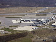
. The population was 3,450 at the 2000 census. The Wilkes-Barre/Scranton International Airport
is located in Pittston Township.
. Years later, coal mining
became the prominent industry in the area.
It remained an active mining
region for many decades, until the Knox Mine Disaster
(1959) in nearby Port Griffith
ended the industry completely.
, the township has a total area of 14.4 square miles (37.2 km²), of which, 14.4 square miles (37.2 km²) of it is land and 0.04 square miles (0.1 km²) of it (0.14%) is water. It is the largest community in all of Greater Pittston
. The township is served by the Pittston Area School District. The eastern part of the township is made up of mountains and thick forests. Most of the township's residents and businesses are located in the western half of the town. The elevation
drops from east to west.
Its villages include Browntown, Glendale, and Suscon. Its numbered routes are U.S. Route 11
, Interstate 81
, Interstate 476
, Route 315
, and Route 502
. The interstates connect via 315 at the Wyoming Valley Interchange just east of Browntown. Suscon Road connects Dupont with Thornhurst on the Lehigh River. Oak Street and William Street (Route 11) connect the township with the city of Pittston.
of 2000, there were 3,450 people, 1,340 households, and 975 families residing in the township. The population density
was 240.2 people per square mile (92.8/km²). There were 1,437 housing units at an average density of 100.1/sq mi (38.6/km²). The racial makeup of the township was 99.16% White, 0.29% African American, 0.09% Asian, 0.06% from other races
, and 0.41% from two or more races. Hispanic or Latino of any race were 0.35% of the population.
There were 1,340 households out of which 27.5% had children under the age of 18 living with them, 55.7% were married couples
living together, 12.1% had a female householder with no husband present, and 27.2% were non-families. 24.4% of all households were made up of individuals and 12.5% had someone living alone who was 65 years of age or older. The average household size was 2.54 and the average family size was 3.03.
In the township the population was spread out with 20.9% under the age of 18, 7.2% from 18 to 24, 28.7% from 25 to 44, 25.3% from 45 to 64, and 17.9% who were 65 years of age or older. The median age was 41 years. For every 100 females there were 97.4 males. For every 100 females age 18 and over, there were 92.0 males.
The median income for a household in the township was $41,339, and the median income for a family was $47,933. Males had a median income of $32,013 versus $22,077 for females. The per capita income
for the township was $18,660. About 7.1% of families and 11.6% of the population were below the poverty line, including 16.0% of those under age 18 and 16.0% of those age 65 or over.
_map.svg.png)
passes through Pittston Township. Combined with all of Interstate 59
and a portion of Interstate 75
, Interstate 81 follows U.S. 11 for its entire journey from New Orleans, Louisiana
to northern New York
State. I-81 does not enter major metropolitan areas; it instead serves smaller cities such as Roanoke
and Winchester, Virginia
; Hagerstown, Maryland
; Harrisburg
, Wilkes-Barre
and Scranton, Pennsylvania
; and Binghamton and Syracuse
, New York
. After passing through Watertown, NY, Interstate 81 crosses the St. Lawrence Seaway
to meet Highway 401
in Canada
. The city
is also located near the Northeast Extension of the Pennsylvania Turnpike
, Interstate 476
providing service from Clarks Summit
to Philadelphia.
is actually in Pittston Township. The airport is serviced by eight international airlines and hosted Air Force One
on regional presidential visits several times in the past. In the spring of 2002, the airport began offering an increased number of non-stop flights across the nation. Service is provided by Continental Airlines
, Delta
, Northwest Airlines
, United Airlines
, and US Airways
.
and Lackawanna County
. Martz Trailways also provides commuter, tour, and trip service from Pittston, nearby Wilkes-Barre and Scranton to points east and south, such as Philadelphia, New York City, and Atlantic City.
, Canadian Pacific Railway
(successor to the Delaware and Hudson) and the Luzerne & Susquehanna Railroad (designated-operator of the county-owned shortline) provide freight service within Pittston City and Pittston Township. A proposed nearby commuter train from Scranton to New York City
has received government funding.
Luzerne County, Pennsylvania
- Demographics :As of the 2010 census, the county was 90.7% White, 3.4% Black or African American, 0.2% Native American, 1.0% Asian, 3.3% were of some other race, and 1.5% were two or more races. 6.7% of the population was of Hispanic or Latino ancestry...
, Pennsylvania
Pennsylvania
The Commonwealth of Pennsylvania is a U.S. state that is located in the Northeastern and Mid-Atlantic regions of the United States. The state borders Delaware and Maryland to the south, West Virginia to the southwest, Ohio to the west, New York and Ontario, Canada, to the north, and New Jersey to...
, United States
United States
The United States of America is a federal constitutional republic comprising fifty states and a federal district...
. The township is located within the Greater Pittston
Greater Pittston
Greater Pittston is a region in Luzerne County, Pennsylvania, in reference to the area in and around Pittston. The total population of the Greater Pittston area is around 50,000 people...
metro area
Metro Area
Metro Area is a Brooklyn-based dance music production team composed of Morgan Geist and Darshan Jesrani.- History :Geist grew up in Wayne, New Jersey, while Jesrani is from upstate New York...
. The population was 3,450 at the 2000 census. The Wilkes-Barre/Scranton International Airport
Wilkes-Barre/Scranton International Airport
Wilkes-Barre/Scranton International Airport is an airport located in Pittston Township, Pennsylvania, near the border of Luzerne County and Lackawanna County, halfway between the cities of Wilkes-Barre and Scranton...
is located in Pittston Township.
History
Pittston Township was established in 1790 by European immigrantsImmigration
Immigration is the act of foreigners passing or coming into a country for the purpose of permanent residence...
. Years later, coal mining
Coal mining
The goal of coal mining is to obtain coal from the ground. Coal is valued for its energy content, and since the 1880s has been widely used to generate electricity. Steel and cement industries use coal as a fuel for extraction of iron from iron ore and for cement production. In the United States,...
became the prominent industry in the area.
It remained an active mining
Mining
Mining is the extraction of valuable minerals or other geological materials from the earth, from an ore body, vein or seam. The term also includes the removal of soil. Materials recovered by mining include base metals, precious metals, iron, uranium, coal, diamonds, limestone, oil shale, rock...
region for many decades, until the Knox Mine Disaster
Knox Mine disaster
The Knox Mine disaster was a mining accident that took place in Port Griffith, a town in Jenkins Township, Pennsylvania, near Pittston, on January 22, 1959....
(1959) in nearby Port Griffith
Port Griffith, Pennsylvania
-External links:* at Mine Country History...
ended the industry completely.
Geography
According to the United States Census BureauUnited States Census Bureau
The United States Census Bureau is the government agency that is responsible for the United States Census. It also gathers other national demographic and economic data...
, the township has a total area of 14.4 square miles (37.2 km²), of which, 14.4 square miles (37.2 km²) of it is land and 0.04 square miles (0.1 km²) of it (0.14%) is water. It is the largest community in all of Greater Pittston
Greater Pittston
Greater Pittston is a region in Luzerne County, Pennsylvania, in reference to the area in and around Pittston. The total population of the Greater Pittston area is around 50,000 people...
. The township is served by the Pittston Area School District. The eastern part of the township is made up of mountains and thick forests. Most of the township's residents and businesses are located in the western half of the town. The elevation
Elevation
The elevation of a geographic location is its height above a fixed reference point, most commonly a reference geoid, a mathematical model of the Earth's sea level as an equipotential gravitational surface ....
drops from east to west.
Its villages include Browntown, Glendale, and Suscon. Its numbered routes are U.S. Route 11
U.S. Route 11
U.S. Route 11 is a north–south United States highway extending 1,645 miles across the eastern United States. The southern terminus of the route is at U.S. Route 90 in the Bayou Sauvage National Wildlife Refuge in eastern New Orleans, Louisiana. The northern terminus is at the United...
, Interstate 81
Interstate 81
Interstate 81 is an Interstate Highway in the eastern part of the United States. Its southern terminus is at Interstate 40 in Dandridge, Tennessee; its northern terminus is on Wellesley Island at the Canadian border, where the Thousand Islands Bridge connects it to Highway 401, the main freeway...
, Interstate 476
Interstate 476
Interstate 476 is a auxiliary Interstate Highway in the U.S. state of Pennsylvania designated between Interstate 95 near Chester and Interstate 81 near Scranton, serving as the primary north–south Interstate corridor through eastern Pennsylvania....
, Route 315
Pennsylvania Route 315
Pennsylvania Route 315 is an long state highway located in Luzerne County in Pennsylvania. The southern terminus is at PA 309 in Wilkes-Barre...
, and Route 502
Pennsylvania Route 502
Pennsylvania Route 502 is an long state highway located in Lackawanna and Luzerne counties in Pennsylvania. The western terminus is at US 11 in Moosic. The eastern terminus is at PA 435 in Covington Township....
. The interstates connect via 315 at the Wyoming Valley Interchange just east of Browntown. Suscon Road connects Dupont with Thornhurst on the Lehigh River. Oak Street and William Street (Route 11) connect the township with the city of Pittston.
Demographics
As of the censusCensus
A census is the procedure of systematically acquiring and recording information about the members of a given population. It is a regularly occurring and official count of a particular population. The term is used mostly in connection with national population and housing censuses; other common...
of 2000, there were 3,450 people, 1,340 households, and 975 families residing in the township. The population density
Population density
Population density is a measurement of population per unit area or unit volume. It is frequently applied to living organisms, and particularly to humans...
was 240.2 people per square mile (92.8/km²). There were 1,437 housing units at an average density of 100.1/sq mi (38.6/km²). The racial makeup of the township was 99.16% White, 0.29% African American, 0.09% Asian, 0.06% from other races
Race (United States Census)
Race and ethnicity in the United States Census, as defined by the Federal Office of Management and Budget and the United States Census Bureau, are self-identification data items in which residents choose the race or races with which they most closely identify, and indicate whether or not they are...
, and 0.41% from two or more races. Hispanic or Latino of any race were 0.35% of the population.
There were 1,340 households out of which 27.5% had children under the age of 18 living with them, 55.7% were married couples
Marriage
Marriage is a social union or legal contract between people that creates kinship. It is an institution in which interpersonal relationships, usually intimate and sexual, are acknowledged in a variety of ways, depending on the culture or subculture in which it is found...
living together, 12.1% had a female householder with no husband present, and 27.2% were non-families. 24.4% of all households were made up of individuals and 12.5% had someone living alone who was 65 years of age or older. The average household size was 2.54 and the average family size was 3.03.
In the township the population was spread out with 20.9% under the age of 18, 7.2% from 18 to 24, 28.7% from 25 to 44, 25.3% from 45 to 64, and 17.9% who were 65 years of age or older. The median age was 41 years. For every 100 females there were 97.4 males. For every 100 females age 18 and over, there were 92.0 males.
The median income for a household in the township was $41,339, and the median income for a family was $47,933. Males had a median income of $32,013 versus $22,077 for females. The per capita income
Per capita income
Per capita income or income per person is a measure of mean income within an economic aggregate, such as a country or city. It is calculated by taking a measure of all sources of income in the aggregate and dividing it by the total population...
for the township was $18,660. About 7.1% of families and 11.6% of the population were below the poverty line, including 16.0% of those under age 18 and 16.0% of those age 65 or over.
Government
A second class township government consists of 3 supervisors, each with equal voting power. The three current supervisors are:- Joseph Adams
- Stephen Rinaldi
- Ron Marcellini
List of recent Pittston Township Supervisors
| Supervisor 1 | Supervisor 2 | Supervisor 3 | |||
|---|---|---|---|---|---|
| Joseph Adams | ? – present | Tony Attardo | 1978–2009 | John Paglianite | ? – 2007 |
| Barbara Attardo | 2009 | Ron Marcellini | 2007 – present | ||
| Stephen Rinaldi | 2009 – present |
Transportation
Highways
Interstate 81Interstate 81 in Pennsylvania
Interstate 81 is an long north–south Interstate Highway, stretching from Dandridge, Tennessee to Fisher's Landing, New York at the US/Canadian border...
passes through Pittston Township. Combined with all of Interstate 59
Interstate 59
Interstate 59 is an Interstate Highway in the southern United States. Its southern terminus is near Slidell, Louisiana, a suburb of New Orleans, at an intersection with Interstate 10 and Interstate 12, its northern terminus is at Wildwood, Georgia, at an intersection with Interstate 24.The road's...
and a portion of Interstate 75
Interstate 75
Interstate 75 is a major north–south Interstate Highway in the Great Lakes and Southeastern regions of the United States. It travels from State Road 826 and State Road 924 in Hialeah, Florida to Sault Ste. Marie, Michigan, at the Ontario, Canada, border...
, Interstate 81 follows U.S. 11 for its entire journey from New Orleans, Louisiana
New Orleans, Louisiana
New Orleans is a major United States port and the largest city and metropolitan area in the state of Louisiana. The New Orleans metropolitan area has a population of 1,235,650 as of 2009, the 46th largest in the USA. The New Orleans – Metairie – Bogalusa combined statistical area has a population...
to northern New York
New York
New York is a state in the Northeastern region of the United States. It is the nation's third most populous state. New York is bordered by New Jersey and Pennsylvania to the south, and by Connecticut, Massachusetts and Vermont to the east...
State. I-81 does not enter major metropolitan areas; it instead serves smaller cities such as Roanoke
Roanoke, Virginia
Roanoke is an independent city in the Mid-Atlantic U.S. state of Virginia and is the tenth-largest city in the Commonwealth. It is located in the Roanoke Valley of the Roanoke Region of Virginia. The population within the city limits was 97,032 as of 2010...
and Winchester, Virginia
Winchester, Virginia
Winchester is an independent city located in the northwestern portion of the Commonwealth of Virginia in the USA. The city's population was 26,203 according to the 2010 Census...
; Hagerstown, Maryland
Hagerstown, Maryland
Hagerstown is a city in northwestern Maryland, United States. It is the county seat of Washington County, and, by many definitions, the largest city in a region known as Western Maryland. The population of Hagerstown city proper at the 2010 census was 39,662, and the population of the...
; Harrisburg
Harrisburg, Pennsylvania
Harrisburg is the capital of Pennsylvania. As of the 2010 census, the city had a population of 49,528, making it the ninth largest city in Pennsylvania...
, Wilkes-Barre
Wilkes-Barre, Pennsylvania
Wilkes-Barre is a city in the U.S. state of Pennsylvania, the county seat of Luzerne County. It is at the center of the Wyoming Valley area and is one of the principal cities in the Scranton/Wilkes-Barre metropolitan area, which had a population of 563,631 as of the 2010 Census...
and Scranton, Pennsylvania
Scranton, Pennsylvania
Scranton is a city in the northeastern part of Pennsylvania, United States. It is the county seat of Lackawanna County and the largest principal city in the Scranton/Wilkes-Barre metropolitan area. Scranton had a population of 76,089 in 2010, according to the U.S...
; and Binghamton and Syracuse
Syracuse, New York
Syracuse is a city in and the county seat of Onondaga County, New York, United States, the largest U.S. city with the name "Syracuse", and the fifth most populous city in the state. At the 2010 census, the city population was 145,170, and its metropolitan area had a population of 742,603...
, New York
New York
New York is a state in the Northeastern region of the United States. It is the nation's third most populous state. New York is bordered by New Jersey and Pennsylvania to the south, and by Connecticut, Massachusetts and Vermont to the east...
. After passing through Watertown, NY, Interstate 81 crosses the St. Lawrence Seaway
Saint Lawrence Seaway
The Saint Lawrence Seaway , , is the common name for a system of locks, canals and channels that permits ocean-going vessels to travel from the Atlantic Ocean to the North American Great Lakes, as far as Lake Superior. Legally it extends from Montreal to Lake Erie, including the Welland Canal...
to meet Highway 401
Highway 401 (Ontario)
King's Highway 401, also known by its official name as the Macdonald–Cartier Freeway and colloquially as the four-oh-one, is a 400-Series Highway in the Canadian province of Ontario stretching from Windsor to the Quebec border...
in Canada
Canada
Canada is a North American country consisting of ten provinces and three territories. Located in the northern part of the continent, it extends from the Atlantic Ocean in the east to the Pacific Ocean in the west, and northward into the Arctic Ocean...
. The city
City
A city is a relatively large and permanent settlement. Although there is no agreement on how a city is distinguished from a town within general English language meanings, many cities have a particular administrative, legal, or historical status based on local law.For example, in the U.S...
is also located near the Northeast Extension of the Pennsylvania Turnpike
Pennsylvania Turnpike
The Pennsylvania Turnpike is a toll highway system operated by the Pennsylvania Turnpike Commission in the Commonwealth of Pennsylvania, United States. The three sections of the turnpike system total . The main section extends from Ohio to New Jersey and is long...
, Interstate 476
Interstate 476
Interstate 476 is a auxiliary Interstate Highway in the U.S. state of Pennsylvania designated between Interstate 95 near Chester and Interstate 81 near Scranton, serving as the primary north–south Interstate corridor through eastern Pennsylvania....
providing service from Clarks Summit
Clarks Summit, Pennsylvania
Clarks Summit is a borough in Lackawanna County northwest of Scranton in northeastern Pennsylvania, United States. The population was 5,116 at the 2010 census. It is also the northern terminus of the Pennsylvania Turnpike Northeast Extension, I-476.-History:...
to Philadelphia.
Air
The Wilkes-Barre/Scranton International AirportWilkes-Barre/Scranton International Airport
Wilkes-Barre/Scranton International Airport is an airport located in Pittston Township, Pennsylvania, near the border of Luzerne County and Lackawanna County, halfway between the cities of Wilkes-Barre and Scranton...
is actually in Pittston Township. The airport is serviced by eight international airlines and hosted Air Force One
Air Force One
Air Force One is the official air traffic control call sign of any United States Air Force aircraft carrying the President of the United States. In common parlance the term refers to those Air Force aircraft whose primary mission is to transport the president; however, any U.S. Air Force aircraft...
on regional presidential visits several times in the past. In the spring of 2002, the airport began offering an increased number of non-stop flights across the nation. Service is provided by Continental Airlines
Continental Airlines
Continental Airlines was a major American airline now merged with United Airlines. On May 3, 2010, Continental Airlines, Inc. and UAL, Inc. announced a merger via a stock swap, and on October 1, 2010, the merger closed and UAL changed its name to United Continental Holdings, Inc...
, Delta
Delta Air Lines
Delta Air Lines, Inc. is a major airline based in the United States and headquartered in Atlanta, Georgia. The airline operates an extensive domestic and international network serving all continents except Antarctica. Delta and its subsidiaries operate over 4,000 flights every day...
, Northwest Airlines
Northwest Airlines
Northwest Airlines, Inc. was a major United States airline founded in 1926 and absorbed into Delta Air Lines by a merger approved on October 29, 2008, making Delta the largest airline in the world...
, United Airlines
United Airlines
United Air Lines, Inc., is the world's largest airline with 86,852 employees United Air Lines, Inc., is the world's largest airline with 86,852 employees United Air Lines, Inc., is the world's largest airline with 86,852 employees (which includes the entire holding company United Continental...
, and US Airways
US Airways
US Airways, Inc. is a major airline based in the U.S. city of Tempe, Arizona. The airline is an operating unit of US Airways Group and is the sixth largest airline by traffic and eighth largest by market value in the country....
.
Public transportation
Pittston is served by the Luzerne County Transportation Authority and COLTS, which provides bus services to the city and other communities within Luzerne CountyLuzerne County, Pennsylvania
- Demographics :As of the 2010 census, the county was 90.7% White, 3.4% Black or African American, 0.2% Native American, 1.0% Asian, 3.3% were of some other race, and 1.5% were two or more races. 6.7% of the population was of Hispanic or Latino ancestry...
and Lackawanna County
Lackawanna County, Pennsylvania
As of the census of 2000, there were 213,295 people, 86,218 households, and 55,783 families residing in the county. The population density was 465 people per square mile . There were 95,362 housing units at an average density of 208 per square mile...
. Martz Trailways also provides commuter, tour, and trip service from Pittston, nearby Wilkes-Barre and Scranton to points east and south, such as Philadelphia, New York City, and Atlantic City.
Rail
At present, the Reading Blue Mountain & Northern RailroadReading Blue Mountain & Northern Railroad
The Reading Blue Mountain and Northern Railroad is a shortline railroad operating in eastern Pennsylvania. It is also known as the Reading and Northern.It operates on of track with two routes...
, Canadian Pacific Railway
Canadian Pacific Railway
The Canadian Pacific Railway , formerly also known as CP Rail between 1968 and 1996, is a historic Canadian Class I railway founded in 1881 and now operated by Canadian Pacific Railway Limited, which began operations as legal owner in a corporate restructuring in 2001...
(successor to the Delaware and Hudson) and the Luzerne & Susquehanna Railroad (designated-operator of the county-owned shortline) provide freight service within Pittston City and Pittston Township. A proposed nearby commuter train from Scranton to New York City
New York City
New York is the most populous city in the United States and the center of the New York Metropolitan Area, one of the most populous metropolitan areas in the world. New York exerts a significant impact upon global commerce, finance, media, art, fashion, research, technology, education, and...
has received government funding.