Tiltmeter
Encyclopedia

Inclinometer
An inclinometer or clinometer is an instrument for measuring angles of slope , elevation or depression of an object with respect to gravity...
. Tiltmeters are used extensively for monitoring volcano
Volcano
2. Bedrock3. Conduit 4. Base5. Sill6. Dike7. Layers of ash emitted by the volcano8. Flank| 9. Layers of lava emitted by the volcano10. Throat11. Parasitic cone12. Lava flow13. Vent14. Crater15...
s, the response of dams to filling, the small movements of potential landslide
Landslide
A landslide or landslip is a geological phenomenon which includes a wide range of ground movement, such as rockfalls, deep failure of slopes and shallow debris flows, which can occur in offshore, coastal and onshore environments...
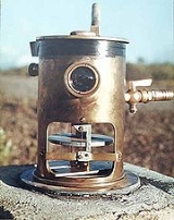
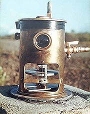
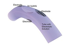
s, the orientation and volume of hydraulic fractures, and the response of structures to various influences such as loading and foundation settlement. Tiltmeters may be purely mechanical or incorporate vibrating-wire or electrolytic sensors for electronic measurement. A sensitive instrument can detect changes of as little as one arc second
Minute of arc
A minute of arc, arcminute, or minute of angle , is a unit of angular measurement equal to one sixtieth of one degree. In turn, a second of arc or arcsecond is one sixtieth of one minute of arc....
.
Tiltmeters have a long history, somewhat parallel to the history of the seismometer
Seismometer
Seismometers are instruments that measure motions of the ground, including those of seismic waves generated by earthquakes, volcanic eruptions, and other seismic sources...
. The very first tiltmeter was a long-length stationary pendulum
Pendulum
A pendulum is a weight suspended from a pivot so that it can swing freely. When a pendulum is displaced from its resting equilibrium position, it is subject to a restoring force due to gravity that will accelerate it back toward the equilibrium position...
. These were used in the very first large concrete dams, and are still in use today, augmented with newer technology such as laser
Laser
A laser is a device that emits light through a process of optical amplification based on the stimulated emission of photons. The term "laser" originated as an acronym for Light Amplification by Stimulated Emission of Radiation...
reflectors. Although they had been used for other applications such as volcano monitoring, they have distinct disadvantages, such as their huge length and sensitivity to air currents. Even in dams, they are slowly being replaced by the modern electronic tiltmeter.
Volcano and earth-movement monitoring then used the water-tube, long baseline tiltmeter. This was a simple arrangement of two water pots, connected by a long water-filled tube. Any change in tilt would be registered by a difference in fill-mark of one pot compared to the other. Although extensively used throughout the world for earth-science research, they have proven to be quite difficult to operate. For example, due to their high sensitivity to temperature differentials, these always have to be read in the middle of the night.

Microelectromechanical systems
Microelectromechanical systems is the technology of very small mechanical devices driven by electricity; it merges at the nano-scale into nanoelectromechanical systems and nanotechnology...
electronics, but it is not clear whether this can eventually displace the common bubble.

Hawaii
Hawaii is the newest of the 50 U.S. states , and is the only U.S. state made up entirely of islands. It is the northernmost island group in Polynesia, occupying most of an archipelago in the central Pacific Ocean, southwest of the continental United States, southeast of Japan, and northeast of...
(Kilauea
Kilauea
Kīlauea is a volcano in the Hawaiian Islands, and one of five shield volcanoes that together form the island of Hawaii. Kīlauea means "spewing" or "much spreading" in the Hawaiian language, referring to its frequent outpouring of lava. The Puu Ōō cone has been continuously erupting in the eastern...
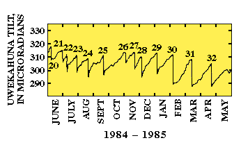
) had a habit of filling the main chamber with magma, and then discharging to a side vent. The graph shows this repeated action, with a pattern of swelling of the main chamber (recorded by the tiltmeter), draining of that chamber, and then an eruption of the adjoining vent. Each number at the peak of tilt, on the graph, is a recorded eruption.
See also
- Tilt testTilt testThe Tilt test is a type of safety test that certain government vehicle certification bodies require new vehicle designs to pass before being allowed on the road or rail track....
- Dam safety systemDam safety systemDam safety systems are systems monitoring the state of dams used for hydropower or other purposes. This includes the use of differential GPS and SAR remote sensing to monitor the risks imposed by landslides and subsidence. For large dams seismographs are used to detect Reservoir Induced...
- Differential GPSDifferential GPSDifferential Global Positioning System is an enhancement to Global Positioning System that provides improved location accuracy, from the 15-meter nominal GPS accuracy to about 10 cm in case of the best implementations....
- Remote sensingRemote sensingRemote sensing is the acquisition of information about an object or phenomenon, without making physical contact with the object. In modern usage, the term generally refers to the use of aerial sensor technologies to detect and classify objects on Earth by means of propagated signals Remote sensing...
methods - Rock mechanicsRock mechanicsRock mechanics is the theoretical and applied science of the mechanical behaviour of rock and rock masses;also compared to the geology, it is that branch of mechanics concerned with the response of rock and rock masses to the force fields of their physical environment.Rock mechanics itself forms...
- Geomechanic

