
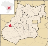
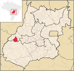
Piranhas, Goiás
Encyclopedia
| Piranhas | |
|---|---|
| State | Goiás Goiás Goiás is a state of Brazil, located in the central part of the country. The name Goiás comes from the name of an indigenous community... |
| Area: | 2,047 km² (10/10/2002) |
| Population: | 11,139 (IBGE 2007) |
| Elevation: | 389m above sea level |
| Postcode (CEP): | 76230-000 |
| Became a city: | 1953 |
| Mayor: | Eurides Naves |
| Distance to Goiânia Goiânia -Climate:The city has a tropical wet and dry climate with an average temperature of . There's a wet season, from October to April, and a dry one, from May to September. Annual rainfall is around 1,520 mm.... : |
321 km. |
| IBGE statistical microregion: | Aragarças Microregion Aragarças Microregion The Aragarças Microregion is a geographical division in Goiás state, Brazil. It consists of 7 municipalities located near Aragarças in western Goiás. For a map see -Important Data :*Population: 53,541*Cities: 7*Total Area: 11,091.90 km²... |
| Website: | n/a |
| Coordinates: | 16°24′59"S 51°48′57"W |
Municipality
A municipality is essentially an urban administrative division having corporate status and usually powers of self-government. It can also be used to mean the governing body of a municipality. A municipality is a general-purpose administrative subdivision, as opposed to a special-purpose district...
in western Goiás
Goiás
Goiás is a state of Brazil, located in the central part of the country. The name Goiás comes from the name of an indigenous community...
state, Brazil
Brazil
Brazil , officially the Federative Republic of Brazil , is the largest country in South America. It is the world's fifth largest country, both by geographical area and by population with over 192 million people...
. It is a large producer of milk and has a large herd of cattle.
Location
Piranhas is located on the Piranhas River and is served by highways: BR-158, which connects JataíJataí
Jataí is a municipality in southern Goiás state, Brazil. Its population was 88,048 in a total area of 7,174.2 km². Jataí is a major producer of agricultural products, including soybeans, rice, and corn. It has the largest herd of cattle in the state and is a large producer of poultry and...
to Aragarças
Aragarças
Aragarças is a small town and municipality in southwest Goiás state, Brazil.-Location:Aragarças is the most important town in the Aragarças Microregion. It is 410 km...
; and GO-060, which connects Piranhas to Iporá
Iporá
Iporá is a small city and municipality in west-central Goiás state, Brazil. The population was 31,060 in a total area of 1,026.4 km² . It is known as the City of the Clear Waters because of its many streams and rivers.-Location:...
.
The distance to the state capital, Goiânia
Goiânia
-Climate:The city has a tropical wet and dry climate with an average temperature of . There's a wet season, from October to April, and a dry one, from May to September. Annual rainfall is around 1,520 mm....
, is 321 km. Highway connections are made by GO-060 / Trindade
Trindade, Goiás
Trindade is a city and municipality in Goiás state, Brazil. It is famous for the religious celebrations held there in July and is now the third most important pilgrimage site in Brazil....
/ Nazário
Nazário
Nazário is a small town and municipality in eastern Goiás state, Brazil.-Location:Nazário is located 74 km. west of the state capital, Goiânia a few kilometers west of the Rio dos Bois, a major tributary of the Paranaíba River. The regional center, Anicuns, is 21 km to the northwest...
/ São Luís de Montes Belos
São Luís de Montes Belos
São Luís de Montes Belos is a small city and municipality in the State of Goiás, Brazil.-Location:It is located in the Anicuns Microregion, 123 kilometers from the state capital, Goiânia, to which it is connected by highway GO-060...
/ Israelândia
Israelândia
Israelândia is a small town and municipality in eastern Goiás state, Brazil.-Location:Israelândia is located in the Iporá Microregion, 28 km. northeast of regional center Iporá. State capital Goiânia is 199 km. to the east...
/ Iporá
Iporá
Iporá is a small city and municipality in west-central Goiás state, Brazil. The population was 31,060 in a total area of 1,026.4 km² . It is known as the City of the Clear Waters because of its many streams and rivers.-Location:...
/ Arenópolis
Arenópolis
Arenópolis is a small town and municipality in eastern Goiás state, Brazil. The population was 3,495 in a total area of 1,074.5 km².-Location and Connections with Goiânia:...
.
Municipal boundaries are with:
- north and west: Bom Jardim de GoiásBom Jardim de GoiásBom Jardim de Goiás is a small town and municipality in western Goiás state, Brazil. The population was 8,372 in a total area of 1,557 km². Bom Jardim is a large producer of cattle.-Location:...
- east: ArenópolisArenópolisArenópolis is a small town and municipality in eastern Goiás state, Brazil. The population was 3,495 in a total area of 1,074.5 km².-Location and Connections with Goiânia:...
- south: Palestina de GoiásPalestina de GoiásPalestina de Goiás is a small town and municipality in eastern Goiás state, Brazil.-Location:Palestina is located in the Sudoeste de Goiás Microregion between the Rio Bonito and the Rio Caiapó. There are paved road connections linking the town to Jataí in the south and to Iporá in the northeast...
and DoverlândiaDoverlândiaDoverlândia is a small city and municipality in eastern Goiás state, Brazil. It is a large producer of cattle and soybeans.-Location and Highway Connections:...
Demographic Information
The population density was 5.44 inhab/km² in 2007. There were 8,872 urban dwellers and 2,267 rural dwellers. The population has declined by about 4,000 people since 1980.Economic Information
The economy is based on mining, agriculture, cattle raising, services, public administration, and small transformation industries. In 2007 there were 19 small transformation industries and 128 commercial units. There were three banks: Banco do Brasil S.A. - BRADESCO S.A. - Banco Itaú S.A.There were two dairies: Maroca Indústria de Laticínios. - Lactosul Ind. de Laticínios Ltda (May 2006)
The main crops in 2006 were pineapple, rice, bananas, beans, manioc, soybeans, and corn. The cattle herd was large with 192,000 head in 2006.
Agricultural data 2006
- Number of farms: 790
- Total area: 207,550 ha.
- Area of permanent crops: 162 ha. (bananas and pineapple)
- Area of perennial crops: 1,421 ha. (soybeans, corn, rice)
- Area of natural pasture: 152,180 ha.
- Area of woodland and forests: 45,753 ha.
- Cattle herd: 192,000
- Number of workers: 1,800
- Number of farms with tractors: 142
- Number of tractors: 179 IBGE
Education and Health
In 2006 there were 12 schools, 103 classrooms, 194 teachers, and 3,602 students. In 2007 there were 3 hospitals with 87 beds.- Higher education: Campus of the State University of Goiás
- Adult literacy rate: 84.8% (2000) (national average was 86.4%)
- Infant mortality rate: 28.24 (2000) (national average was 33.0).
Tourism
There is potential for eco-tourism with conditions for hiking, going down rapids, and other sports activities practiced near nature. The São Domingos river is ideal for canoeing, and descending on rafts or tire-tubes. Hikers can walk through virgin forests, which have unexplored caves.- Municipal Human Development IndexHuman Development IndexThe Human Development Index is a composite statistic used to rank countries by level of "human development" and separate "very high human development", "high human development", "medium human development", and "low human development" countries...
: 0.773 - Ranking in state: 118/245
- National ranking: 2249/5507
History
Settlement began in 1948 when engineers and workers building the road between CaiapôniaCaiapônia
Caiapônia is a small town and municipality in south-central Goiás state, Brazil. It has the third largest cattle herd in the state and is a major producer of grains. The town is also known as Torres Do Rio Bonito or just Rio Bonito.-Geography:...
and Aragarças
Aragarças
Aragarças is a small town and municipality in southwest Goiás state, Brazil.-Location:Aragarças is the most important town in the Aragarças Microregion. It is 410 km...
arrived in the region and set up camp on the banks of the Piranhas River. A settlement was created with the name of Piranhas, after the river. In 1952 it became a district of Caiapônia
Caiapônia
Caiapônia is a small town and municipality in south-central Goiás state, Brazil. It has the third largest cattle herd in the state and is a major producer of grains. The town is also known as Torres Do Rio Bonito or just Rio Bonito.-Geography:...
, receiving its municipal autonomy in 1953.
Sources of Data
For the complete list see Frigoletto.com.br