
Bom Jardim de Goiás
Encyclopedia
| Bom Jardim de Goiás | |
|---|---|
| State | Goiás Goiás Goiás is a state of Brazil, located in the central part of the country. The name Goiás comes from the name of an indigenous community... |
| Area: | 1,557 km² |
| Population: | 8,372 (IBGE 2007) |
| Urban and Rural Population: | 6,102 / 2,270 |
| Population density: | 4.52 inhab/km² (2007) |
| Elevation: | 386 m above sea level |
| Postcode (CEP): | 73245-000 |
| IBGE statistical microregion: | Aragarças Microregion Aragarças Microregion The Aragarças Microregion is a geographical division in Goiás state, Brazil. It consists of 7 municipalities located near Aragarças in western Goiás. For a map see -Important Data :*Population: 53,541*Cities: 7*Total Area: 11,091.90 km²... |
| Became a city: | 1953 |
| Mayor: | Manoel Luiz Alves |
| Distance to Goiânia Goiânia -Climate:The city has a tropical wet and dry climate with an average temperature of . There's a wet season, from October to April, and a dry one, from May to September. Annual rainfall is around 1,520 mm.... : |
371 km. |
| Website: | none |
| Coordinates: | 16°12′06"S 52°10′13"W |
Municipality
A municipality is essentially an urban administrative division having corporate status and usually powers of self-government. It can also be used to mean the governing body of a municipality. A municipality is a general-purpose administrative subdivision, as opposed to a special-purpose district...
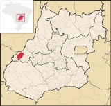
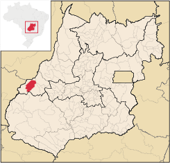
in western Goiás
Goiás
Goiás is a state of Brazil, located in the central part of the country. The name Goiás comes from the name of an indigenous community...
state, Brazil
Brazil
Brazil , officially the Federative Republic of Brazil , is the largest country in South America. It is the world's fifth largest country, both by geographical area and by population with over 192 million people...
. The population was 8,372 (2007) in a total area of 1,557 km². Bom Jardim is a large producer of cattle.
Location
Bom Jardim is located 371 km. from the state capital, GoiâniaGoiânia
-Climate:The city has a tropical wet and dry climate with an average temperature of . There's a wet season, from October to April, and a dry one, from May to September. Annual rainfall is around 1,520 mm....
. It is almost due west of the capital and is just south of Aragarças
Aragarças
Aragarças is a small town and municipality in southwest Goiás state, Brazil.-Location:Aragarças is the most important town in the Aragarças Microregion. It is 410 km...
on the Araguaia River
Araguaia River
The Araguaia River or, in Portuguese, Rio Araguaia is one of the major rivers of Brazil, and the principal tributary of the Tocantins. It has a total length of approximately 2,627 km. Araguaia means "river of macaws" in the Tupi language....
. Highway connections from Goiânia
Goiânia
-Climate:The city has a tropical wet and dry climate with an average temperature of . There's a wet season, from October to April, and a dry one, from May to September. Annual rainfall is around 1,520 mm....
are made by GO-060 / Trindade
Trindade, Goiás
Trindade is a city and municipality in Goiás state, Brazil. It is famous for the religious celebrations held there in July and is now the third most important pilgrimage site in Brazil....
/ Turvânia
Turvânia
Turvânia is a small town and municipality in eastern Goiás state, Brazil.-Location:Turvânia is located west of Goiânia, east of São Luís de Montes Belos....
/ Israelândia
Israelândia
Israelândia is a small town and municipality in eastern Goiás state, Brazil.-Location:Israelândia is located in the Iporá Microregion, 28 km. northeast of regional center Iporá. State capital Goiânia is 199 km. to the east...
/ Iporá
Iporá
Iporá is a small city and municipality in west-central Goiás state, Brazil. The population was 31,060 in a total area of 1,026.4 km² . It is known as the City of the Clear Waters because of its many streams and rivers.-Location:...
/ Piranhas
Piranhas, Goiás
Piranhas is a small town and municipality in western Goiás state, Brazil. It is a large producer of milk and has a large herd of cattle.-Location:...
/ BR-158.
The municipality has boundaries with Aragarças
Aragarças
Aragarças is a small town and municipality in southwest Goiás state, Brazil.-Location:Aragarças is the most important town in the Aragarças Microregion. It is 410 km...
, Baliza
Baliza
Baliza is a small town and municipality in eastern Goiás state, Brazil. The population was 3,299 in a total area of 1,783.00 km².-Location:...
, Caiapônia
Caiapônia
Caiapônia is a small town and municipality in south-central Goiás state, Brazil. It has the third largest cattle herd in the state and is a major producer of grains. The town is also known as Torres Do Rio Bonito or just Rio Bonito.-Geography:...
, Piranhas
Piranhas, Goiás
Piranhas is a small town and municipality in western Goiás state, Brazil. It is a large producer of milk and has a large herd of cattle.-Location:...
, and Montes Claros de Goiás
Montes Claros de Goiás
Montes Claros de Goiás is a small town and municipality in western Goiás state, Brazil-Location and connections:Montes Claros is located in the extreme west of the state, about 70 km east of the Araguaia River. It is east of Aragarças and west of Jussara.Montes Claros is connected by poor...
. Important rivers are the Piranhas, Macaco and Bom Jardim.
Economy
The economy is based on cattle raising and agriculture. The lands produce rice, bananas, hearts of palm, beans, corn, soybeans and others. There are also deposits of copper and granite. There were 136,000 head of cattle in 2007.The main areas of employment in 2007 were commerce, small transformation industries, agriculture, public administration, and the informal economy. There were 2 financial institutions in 2007--Banco do Brasil S.A. and Bradesco S.A.
Agricultural data 2006
- Number of farms: 832
- Total area: 176,795 ha.
- Area of permanent crops: 162 ha. (bananas, sugarcane, and hearts of palm)
- Area of perennial crops: 1,238 ha. (soybeans, corn, rice)
- Area of natural pasture: 131,817 ha.
- Area of woodland and forests: 42,006 ha.
- Cattle herd: 136,000
- Number of agricultural workers: 2,800
- Number of farms with tractors: 99
- Number of tractors: 111 IBGE
Health and education
- Infant Mortality in 2000: 21.93 for 1,000 live births
- Literacy rate in 2000: 84,6
- Hospitals: 02 with 44 beds
- Schools; 7 with 2,195 students
- Municipal Human Development IndexHuman Development IndexThe Human Development Index is a composite statistic used to rank countries by level of "human development" and separate "very high human development", "high human development", "medium human development", and "low human development" countries...
: 0.737 - State ranking: 117 (out of 242 municipalities)
- National ranking: 2,247 (out of 5,507 municipalities)
History
Before European exploration this region was inhabited by the Bororó Indians. In the middle of the nineteenth century Manoel Perdigão discovered gold at a place called Buriti on the banks of the Macacos River. In 1912 the Felizardo family arrived and began a farm called Bom Jardim. A chapel was built in 1914 and Dona Ana Rufina de Faria donated lands for a future town. In 1924 Bom Jardim was elevated to the category of district in the municipality of Rio Bonito, which is present-day CaiapôniaCaiapônia
Caiapônia is a small town and municipality in south-central Goiás state, Brazil. It has the third largest cattle herd in the state and is a major producer of grains. The town is also known as Torres Do Rio Bonito or just Rio Bonito.-Geography:...
. In 1943 the name was changed to Ibotim, of unknown origin, and in 1953 it became a municipality, with the new name of Bom Jardim de Goiás.