
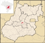
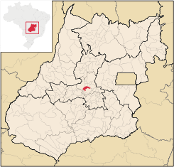
Itauçu
Encyclopedia
| Itauçu | |
|---|---|
| State | Goiás Goiás Goiás is a state of Brazil, located in the central part of the country. The name Goiás comes from the name of an indigenous community... |
| Coordinates: | 16°12′14"S 49°36′09"W |
| Area: | 383.7 km² |
| Population: | 8,710 (IBGE 2007 estimate) |
| Population Density: | 22.70 hab/km² (2007) |
| Elevation: | 839 m above sea level |
| Postcode (CEP): | 75450-000 |
| Became a city: | 1948 |
| Distance to Goiânia Goiânia -Climate:The city has a tropical wet and dry climate with an average temperature of . There's a wet season, from October to April, and a dry one, from May to September. Annual rainfall is around 1,520 mm.... : |
64 km. |
| IBGE statistical microregion: | Anápolis Microregion Anápolis Microregion The Anápolis Microregion is a region of central Goiás state, Brazil, including municipalities surrounding the city of Anápolis. For a map see *Population: 517,221 inhabitants *Cities: 19*Total Area: 8,386.80 km²... |
| Website: | n/a |
Town
A town is a human settlement larger than a village but smaller than a city. The size a settlement must be in order to be called a "town" varies considerably in different parts of the world, so that, for example, many American "small towns" seem to British people to be no more than villages, while...
and municipality
Municipality
A municipality is essentially an urban administrative division having corporate status and usually powers of self-government. It can also be used to mean the governing body of a municipality. A municipality is a general-purpose administrative subdivision, as opposed to a special-purpose district...
in central Goiás
Goiás
Goiás is a state of Brazil, located in the central part of the country. The name Goiás comes from the name of an indigenous community...
state, Brazil
Brazil
Brazil , officially the Federative Republic of Brazil , is the largest country in South America. It is the world's fifth largest country, both by geographical area and by population with over 192 million people...
.
Location
Itauçu is located 64 km. northwest of the state capital, GoiâniaGoiânia
-Climate:The city has a tropical wet and dry climate with an average temperature of . There's a wet season, from October to April, and a dry one, from May to September. Annual rainfall is around 1,520 mm....
and is part of the Anápolis Microregion
Anápolis Microregion
The Anápolis Microregion is a region of central Goiás state, Brazil, including municipalities surrounding the city of Anápolis. For a map see *Population: 517,221 inhabitants *Cities: 19*Total Area: 8,386.80 km²...
. It is connected to the capital by highway BR-070, which links Goiânia
Goiânia
-Climate:The city has a tropical wet and dry climate with an average temperature of . There's a wet season, from October to April, and a dry one, from May to September. Annual rainfall is around 1,520 mm....
with Aragarças
Aragarças
Aragarças is a small town and municipality in southwest Goiás state, Brazil.-Location:Aragarças is the most important town in the Aragarças Microregion. It is 410 km...
.
It has boundaries with the following municipalities:
- north: Taquaral de GoiásTaquaral de GoiásTaquaral de Goiás is a small town and municipality in central Goiás state, Brazil.-Location:Taquaral is located approximately 100 km. northwest of regional center, Anápolis. It is 22 km. west of Santa Rosa de Goiás and 25 km. east of Itaberaí...
and Santa Rosa de GoiásSanta Rosa de GoiásSanta Rosa de Goiás is a small town and municipality in central Goiás state, Brazil.-Location:Santa Rosa is located 78 km. northwest of the regional center, Anápolis. It is approximately half the distance between Taquaral de Goiás and Petrolina de Goiás. Highway connections are made from... - west: ItaberaíItaberaíItaberaí is a small city and municipality in central Goiás state, Brazil. Itaberaí is a large producer of agricultural products including corn, rice, soybeans, tomatoes, and sugarcane.-Location:...
- east: Petrolina de GoiásPetrolina de GoiásPetrolina de Goiás is a small town and municipality in central Goiás state, Brazil.-Location:Petrolina de Goiás is located 81 km. almost due north of Goiânia, the state capital. It is 23 km. southwest of São Francisco de Goiás, 23 km. northwest of Ouro Verde de Goiás, 21 km....
- south: AraçuAraçuAraçu is a small town and municipality in central Goiás state, Brazil.-Location:Araçu is part of the Anápolis Microregion and is a short distance northwest of the state capital, Goiânia. It has boundaries with Itaberaí, Itauçu, and Caturaí...
and InhumasInhumasInhumas is a small city and municipality in central Goiás state, Brazil. The population was 47,361 in a total area of 613.3 km²...
Demographics
- Population growth rate 1991/2000: 0.24.%
- Population in 2007: 8,710
- Population in 1980: 9,770
- Urban population in 2007: 6,404
- Rural population in 2007: 2,306
The economy
The economy is based on cattle raising (49,000 head in 2004) and cultivation of soybeans, rice, corn, sugarcane, and beans.- Number of industrial establishments: 24
- Number of retail establishments: 71
- Banking establishments: Banco Itaú S.A.
- Dairies: Laticínios Alvorada Ind. Com. Ltda. (22/05/2006)
- Automobiles: 757
Agricultural data 2006
- Farms: 446
- Total area: 41,650 ha.
- Area of permanent crops: 21,088 ha. (bananas, sugarcane, citrus fruits)
- Area of perennial crops: 3,555 ha.
- Area of natural pasture: 3,618 ha.
- Area of woodland and forests: 3,471 ha.
- Persons dependent on farming: 1,000
- Farms with tractors: 19
- Number of tractors: 24
- Cattle herd: 49,000 head IBGE
Health and education
In the educational sector there were 9 schools in activity in 2006, with 2,128 students. The literacy rate was 85.1%. In the health sector there was 1 hospital with 22 beds. The infant mortality rate was 19.60 (in 1,000 live births)Itauçu had a score of 0.742 (2000) on the Municipal Human Development Index
Human Development Index
The Human Development Index is a composite statistic used to rank countries by level of "human development" and separate "very high human development", "high human development", "medium human development", and "low human development" countries...
giving a state ranking of 103 (out of 242 municipalities in 2000) and a national ranking of 2,118 (out of 5,507 municipalities in 2000). For the complete list see frigoletto.com.br
Sources of Data
See also
List of municipalities in Goiás