
Pennsylvania Regions
Encyclopedia
Geographic regions of the Commonwealth
of Pennsylvania
, United States of America
.
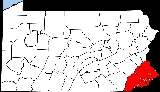
 The Delaware Valley is named for the Delaware River which flows through the region.
Consisting of the following counties:
This valley primarily contains the Philadelphia Metro Area.
 The Pennsylvania Piedmont region is a heavily agricultural section of the Piedmont Plateau located in Eastern Pennsylvania frequently cited as a candidate for extensive ecological preservation.
Consisting of the following counties:
 Pennsylvania Dutch Country refers to an area of southeastern Pennsylvania that has a high percentage of Amish, Mennonite and "Fancy Dutch" inhabitants and where the Pennsylvania German language was historically common.
Consisting of the following counties:
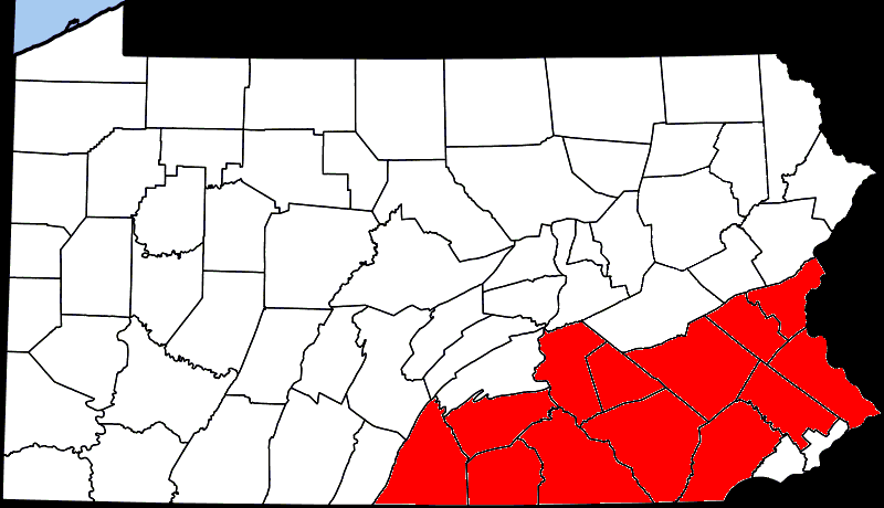
 Located along the Lehigh River
.
Consisting of following counties:
This valley primarily contains the Allentown Metro Area.
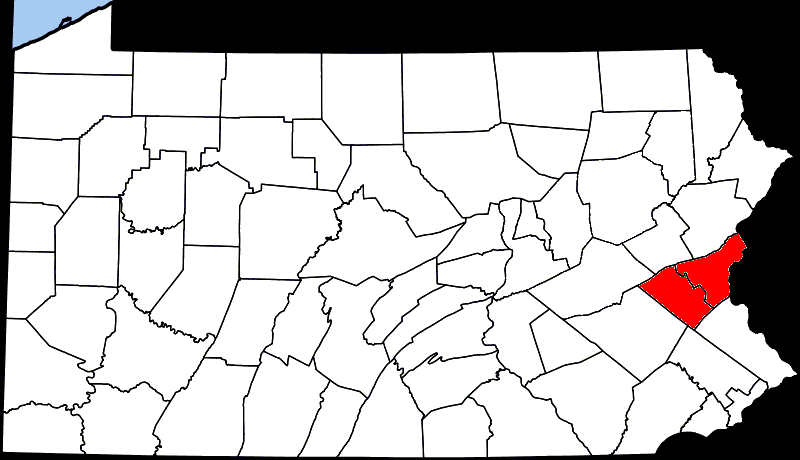
 This mountainous area of Pennsylvania
includes the Pocono Mountains, the Endless Mountains
and former anthracite coal
mining cities, boroughs, and villages.
Consisting of the following counties:
Consisting of the following counties:
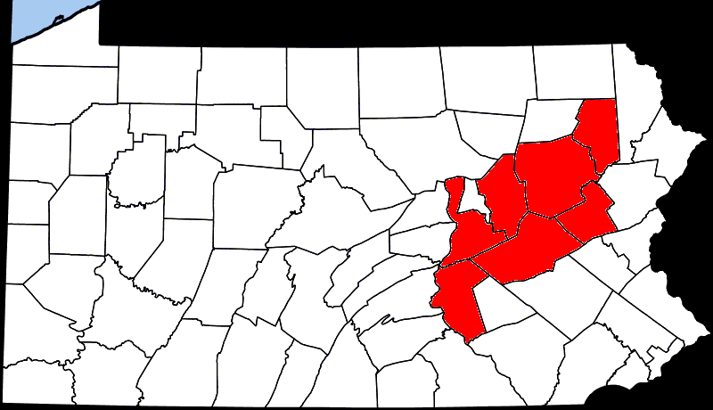 The Coal Region is a term used to refer to an area of Northeastern Pennsylvania in the central Appalachian Mountains. The region is home to the largest known deposits of anthracite coal found in the Americas, with an estimated reserve of seven billion short tons.
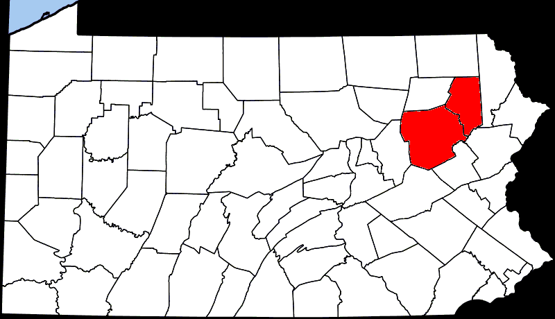 Wyoming Valley is a region of northeastern Pennsylvania. The valley is a crescent-shaped depression, a part of the ridge-and-valley or folded Appalachians, which includes the metropolitan areas of Scranton, and Wilkes-Barre, Pennsylvania.
Consisting of the following counties:
This valley primarily contains the Wilkes-Barre Metro Area and the Scranton Metro Area.
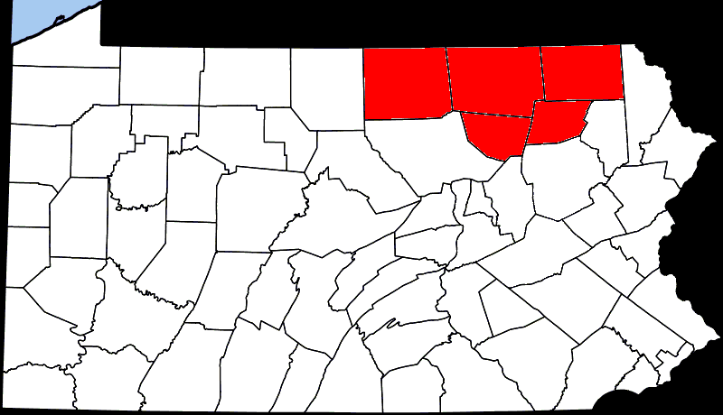
 The Endless Mountains are a chain of mountains in northeastern Pennsylvania which are part of the Appalachian Mountains
chain. The "mountains" are not true mountains, geologically speaking, but are a dissected plateau and are part of the Allegheny Plateau
, along with the higher Catskill Mountains
to the east of the Endless Mountains in New York
.
Consisting of the following counties:
 The Northern Tier is a geographic region in north-central Pennsylvania.
Consisting of the following counties:
 The Susquehanna River is a river in the northeastern United States. At approximately 410 mi (715 km) long, it is the longest river on the American East Coast.
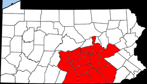 South Central Pennsylvania is a geographic region that lies between the Delaware Valley
and Western Pennsylvania
, United States.
Consisting of the following counties:
 Happy Valley is a large valley located in central Pennsylvania. The Pennsylvania State University
is located in the valley.
Consisting of the following county:
 The Cumberland Valley is a geographic region that lies between South Mountain and the Blue Ridge Mountains of central Pennsylvania and western Maryland, United States.
Consisting of the following counties:
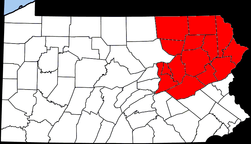
 The Laurel Highlands, in the southwestern part of the state of Pennsylvania, traverses the Laurel and Chestnut ridges of the Allegheny Mountains
.
Consisting of the following counties:
 Consisting of the following counties:
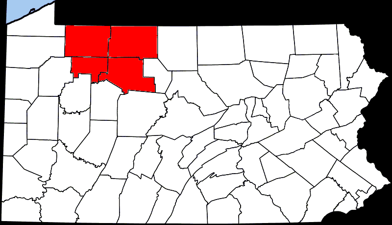 The Allegheny National Forest is a National Forest located in northwestern Pennsylvania. The forest covers over 500,000 acres (2,000 km²) of land.
Consisting of the following counties:

Commonwealth (United States)
Four of the constituent states of the United States officially designate themselves Commonwealths: Kentucky, Massachusetts, Pennsylvania and Virginia....
of Pennsylvania
Pennsylvania
The Commonwealth of Pennsylvania is a U.S. state that is located in the Northeastern and Mid-Atlantic regions of the United States. The state borders Delaware and Maryland to the south, West Virginia to the southwest, Ohio to the west, New York and Ontario, Canada, to the north, and New Jersey to...
, United States of America
United States
The United States of America is a federal constitutional republic comprising fifty states and a federal district...
.
Delaware Valley
Consisting of the following counties:
- BucksBucks County, Pennsylvania- Industry and commerce :The boroughs of Bristol and Morrisville were prominent industrial centers along the Northeast Corridor during World War II. Suburban development accelerated in Lower Bucks in the 1950s with the opening of Levittown, Pennsylvania, the second such "Levittown" designed by...
- PhiladelphiaPhiladelphia County, Pennsylvania-History:Tribes of Lenape were the first known occupants in the area which became Philadelphia County. The first European settlers were Swedes and Finns who arrived in 1638. The Netherlands seized the area in 1655, but permanently lost control to England in 1674...
- DelawareDelaware County, PennsylvaniaDelaware County is a county located in the U.S. state of Pennsylvania. As of 2010, the population was 558,979, making it Pennsylvania's fifth most populous county, behind Philadelphia, Allegheny, Montgomery, and Bucks counties....
- MontgomeryMontgomery County, PennsylvaniaMontgomery County is a county located in the U.S. state of Pennsylvania, in the United States. As of 2010, the population was 799,874, making it the third most populous county in Pennsylvania . The county seat is Norristown.The county was created on September 10, 1784, out of land originally part...
- ChesterChester County, Pennsylvania-State parks:*French Creek State Park*Marsh Creek State Park*White Clay Creek Preserve-Demographics:As of the 2010 census, the county was 85.5% White, 6.1% Black or African American, 0.2% Native American or Alaskan Native, 3.9% Asian, 0.0% Native Hawaiian, 1.8% were two or more races, and 2.4% were...
This valley primarily contains the Philadelphia Metro Area.
Pennsylvania Piedmont
Consisting of the following counties:
- FranklinFranklin County, PennsylvaniaAs of the census of 2000, there were 129,313 people, 50,633 households, and 36,405 families residing in the county. The population density was 168 people per square mile . There were 53,803 housing units at an average density of 70 per square mile...
- AdamsAdams County, PennsylvaniaAdams County is a county in the U.S. state of Pennsylvania. As of the 2010 census, the population was 101,407. It was created on January 22, 1800, from part of York County and named in honor of the second President of the United States, John Adams...
- CumberlandCumberland County, PennsylvaniaCumberland County is a county located in the U.S. state of Pennsylvania and is one of three counties comprising the Harrisburg–Carlisle Metropolitan Statistical Area. As of 2010, the population was 235,406.-History:...
- YorkYork County, PennsylvaniaYork County is a county in the U.S. state of Pennsylvania. As of 2010, the population was 434,972. It is in the Susquehanna Valley, a large fertile agricultural region in South Central Pennsylvania....
- DauphinDauphin County, PennsylvaniaDauphin County is a county in the U.S. state of Pennsylvania and is one of the three counties comprising the Harrisburg–Carlisle Metropolitan Statistical Area. As of 2010 census, the population was 268,100. The county includes the city of Harrisburg, which has served as the state capital...
- LancasterLancaster County, PennsylvaniaLancaster County, known as the Garden Spot of America or Pennsylvania Dutch Country, is a county located in the southeastern part of the Commonwealth of Pennsylvania, in the United States. As of 2010 the population was 519,445. Lancaster County forms the Lancaster Metropolitan Statistical Area, the...
- LebanonLebanon County, PennsylvaniaAs of the census of 2000, there were 120,327 people and 32,771 families residing in the county. The population density was 332 people per square mile . There were 49,320 housing units at an average density of 136 per square mile...
- ChesterChester County, Pennsylvania-State parks:*French Creek State Park*Marsh Creek State Park*White Clay Creek Preserve-Demographics:As of the 2010 census, the county was 85.5% White, 6.1% Black or African American, 0.2% Native American or Alaskan Native, 3.9% Asian, 0.0% Native Hawaiian, 1.8% were two or more races, and 2.4% were...
- BerksBerks County, Pennsylvania-Demographics:As of the census of 2000, there were 373,638 people, 141,570 households, and 98,532 families residing in the county. The population density was 435 people per square mile . There were 150,222 housing units at an average density of 175 per square mile...
- MontgomeryMontgomery County, PennsylvaniaMontgomery County is a county located in the U.S. state of Pennsylvania, in the United States. As of 2010, the population was 799,874, making it the third most populous county in Pennsylvania . The county seat is Norristown.The county was created on September 10, 1784, out of land originally part...
- BucksBucks County, Pennsylvania- Industry and commerce :The boroughs of Bristol and Morrisville were prominent industrial centers along the Northeast Corridor during World War II. Suburban development accelerated in Lower Bucks in the 1950s with the opening of Levittown, Pennsylvania, the second such "Levittown" designed by...
- LehighLehigh County, Pennsylvania-Climate:Most of the county's climate is considered to fall in the humid continental climate zone. Summers are typically hot and muggy, fall and spring are generally mild, and winter is cold. Precipitation is almost uniformly distributed throughout the year....
- NorthamptonNorthampton County, PennsylvaniaAs of the 2010 census, the county was 86.3% White, 5.0% Black or African American, 0.2% Native American or Alaskan Native, 2.4% Asian, 0.0% Native Hawaiian, 2.2% were two or more races, and 3.8% were some other race. 10.5% of the population were of Hispanic or Latino ancestry.As of the census of...
Pennsylvania Dutch Country
Consisting of the following counties:
- LehighLehigh County, Pennsylvania-Climate:Most of the county's climate is considered to fall in the humid continental climate zone. Summers are typically hot and muggy, fall and spring are generally mild, and winter is cold. Precipitation is almost uniformly distributed throughout the year....
- BerksBerks County, Pennsylvania-Demographics:As of the census of 2000, there were 373,638 people, 141,570 households, and 98,532 families residing in the county. The population density was 435 people per square mile . There were 150,222 housing units at an average density of 175 per square mile...
- LebanonLebanon County, PennsylvaniaAs of the census of 2000, there were 120,327 people and 32,771 families residing in the county. The population density was 332 people per square mile . There were 49,320 housing units at an average density of 136 per square mile...
- DauphinDauphin County, PennsylvaniaDauphin County is a county in the U.S. state of Pennsylvania and is one of the three counties comprising the Harrisburg–Carlisle Metropolitan Statistical Area. As of 2010 census, the population was 268,100. The county includes the city of Harrisburg, which has served as the state capital...
- LancasterLancaster County, PennsylvaniaLancaster County, known as the Garden Spot of America or Pennsylvania Dutch Country, is a county located in the southeastern part of the Commonwealth of Pennsylvania, in the United States. As of 2010 the population was 519,445. Lancaster County forms the Lancaster Metropolitan Statistical Area, the...
- YorkYork County, PennsylvaniaYork County is a county in the U.S. state of Pennsylvania. As of 2010, the population was 434,972. It is in the Susquehanna Valley, a large fertile agricultural region in South Central Pennsylvania....
- PerryPerry County, PennsylvaniaAs of the census of 2000, there were 43,602 people, 16,695 households, and 12,320 families residing in the county. The population density was 79 people per square mile . There were 18,941 housing units at an average density of 34 per square mile...
- CumberlandCumberland County, PennsylvaniaCumberland County is a county located in the U.S. state of Pennsylvania and is one of three counties comprising the Harrisburg–Carlisle Metropolitan Statistical Area. As of 2010, the population was 235,406.-History:...
- AdamsAdams County, PennsylvaniaAdams County is a county in the U.S. state of Pennsylvania. As of the 2010 census, the population was 101,407. It was created on January 22, 1800, from part of York County and named in honor of the second President of the United States, John Adams...
- FranklinFranklin County, PennsylvaniaAs of the census of 2000, there were 129,313 people, 50,633 households, and 36,405 families residing in the county. The population density was 168 people per square mile . There were 53,803 housing units at an average density of 70 per square mile...
Lehigh Valley
Lehigh River
The Lehigh River, a tributary of the Delaware River, is a river located in eastern Pennsylvania, in the United States. Part of the Lehigh, along with a number of its tributaries, is designated a Pennsylvania Scenic River by the state's Department of Conservation and Natural Resources...
.
Consisting of following counties:
- LehighLehigh County, Pennsylvania-Climate:Most of the county's climate is considered to fall in the humid continental climate zone. Summers are typically hot and muggy, fall and spring are generally mild, and winter is cold. Precipitation is almost uniformly distributed throughout the year....
- NorthamptonNorthampton County, PennsylvaniaAs of the 2010 census, the county was 86.3% White, 5.0% Black or African American, 0.2% Native American or Alaskan Native, 2.4% Asian, 0.0% Native Hawaiian, 2.2% were two or more races, and 3.8% were some other race. 10.5% of the population were of Hispanic or Latino ancestry.As of the census of...
This valley primarily contains the Allentown Metro Area.
Northeastern Pennsylvania
Pennsylvania
The Commonwealth of Pennsylvania is a U.S. state that is located in the Northeastern and Mid-Atlantic regions of the United States. The state borders Delaware and Maryland to the south, West Virginia to the southwest, Ohio to the west, New York and Ontario, Canada, to the north, and New Jersey to...
includes the Pocono Mountains, the Endless Mountains
Endless Mountains
The Endless Mountains are a chain of mountains in northeastern Pennsylvania. The Endless Mountains region includes Bradford, Sullivan, Susquehanna, Northern Wayne, and Wyoming Counties.-History and geography:...
and former anthracite coal
Anthracite coal
Anthracite is a hard, compact variety of mineral coal that has a high luster...
mining cities, boroughs, and villages.
Consisting of the following counties:
- PikePike County, Pennsylvania-National protected areas:* Delaware Water Gap National Recreation Area * Middle Delaware National Scenic River * Upper Delaware Scenic and Recreational River -Demographics:...
- LuzerneLuzerne County, Pennsylvania- Demographics :As of the 2010 census, the county was 90.7% White, 3.4% Black or African American, 0.2% Native American, 1.0% Asian, 3.3% were of some other race, and 1.5% were two or more races. 6.7% of the population was of Hispanic or Latino ancestry...
- LackawannaLackawanna County, PennsylvaniaAs of the census of 2000, there were 213,295 people, 86,218 households, and 55,783 families residing in the county. The population density was 465 people per square mile . There were 95,362 housing units at an average density of 208 per square mile...
- MonroeMonroe County, Pennsylvania-National protected areas:* Delaware Water Gap National Recreation Area * Middle Delaware National Scenic River -Demographics:As of the census of 2010, there are 176,567 people, 49,454 households, and 36,447 families residing in the county. The population density was 228 people per square mile...
- MontourMontour County, PennsylvaniaMontour County is located in the U.S. state of Pennsylvania. In 2010, the county's population was 18,267. Its county seat is Danville. It is named for Andrew Montour, a prominent métis interpreter who served with George Washington during the French and Indian War. The county is part of the...
- WyomingWyoming County, PennsylvaniaWyoming County is a county located in the U.S. state of Pennsylvania. It was created in 1842 from part of Luzerne County. Its county seat is Tunkhannock.-Geography:According to the U.S...
- BradfordBradford County, Pennsylvania-Demographics:As of the census of 2000, there were 62,761 people, 24,453 households, and 17,312 families residing in the county. The population density was 54 people per square mile . There were 28,664 housing units at an average density of 25 per square mile...
- CarbonCarbon County, PennsylvaniaAs of the census of 2000, there were 58,802 people, 23,701 households, and 16,424 families residing in the county. The population density was 154 people per square mile . There were 30,492 housing units at an average density of 80 per square mile...
- ColumbiaColumbia County, PennsylvaniaAs of the census of 2000, there were 64,151 people, 24,915 households, and 16,568 families residing in the county. The population density was 132 people per square mile . There were 27,733 housing units at an average density of 57 per square mile...
- NorthumberlandNorthumberland County, PennsylvaniaThere were 38,835 households out of which 27.30% had children under the age of 18 living with them, 52.40% were married couples living together, 9.60% had a female householder with no husband present, and 34.10% were non-families. 30.20% of all households were made up of individuals and 15.50% had...
- SchuylkillSchuylkill County, Pennsylvania-Notable people:*Boxing heavyweight great Muhammad Ali had his training camp in Deer Lake.*Charles Justin Bailey, commanding general of the 81st Division in World War I, was born in Tamaqua on June 21, 1859....
- SullivanSullivan County, PennsylvaniaSullivan County is a county located in the U.S. state of Pennsylvania. As of 2010, the population is 6,428. Sullivan County was created on March 15, 1847, from part of Lycoming County and named for Charles Sullivan, leader of the Pennsylvania Senate...
- SusquehannaSusquehanna County, Pennsylvania-Demographics:As of the census of 2000, there were 42,238 people, 16,529 households, and 11,785 families residing in the county. The population density was 51 people per square mile . There were 21,829 housing units at an average density of 26 per square mile...
The Poconos
The Poconos, or the Pocono Mountains region, is a mountainous region of about 2,400 square miles (6,200 km²) located in northeastern Pennsylvania, approximately 30 miles north of Allentown, which are a popular recreational destination for local and regional visitors.Consisting of the following counties:
- CarbonCarbon County, PennsylvaniaAs of the census of 2000, there were 58,802 people, 23,701 households, and 16,424 families residing in the county. The population density was 154 people per square mile . There were 30,492 housing units at an average density of 80 per square mile...
- MonroeMonroe County, Pennsylvania-National protected areas:* Delaware Water Gap National Recreation Area * Middle Delaware National Scenic River -Demographics:As of the census of 2010, there are 176,567 people, 49,454 households, and 36,447 families residing in the county. The population density was 228 people per square mile...
- PikePike County, Pennsylvania-National protected areas:* Delaware Water Gap National Recreation Area * Middle Delaware National Scenic River * Upper Delaware Scenic and Recreational River -Demographics:...
- WayneWayne County, PennsylvaniaAs of the census of 2000, there were 47,722 people, 18,350 households, and 12,936 families residing in the county. The population density was 65 people per square mile . There were 30,593 housing units at an average density of 42 per square mile...
- LuzerneLuzerne County, Pennsylvania- Demographics :As of the 2010 census, the county was 90.7% White, 3.4% Black or African American, 0.2% Native American, 1.0% Asian, 3.3% were of some other race, and 1.5% were two or more races. 6.7% of the population was of Hispanic or Latino ancestry...
- SusquehannaSusquehanna County, Pennsylvania-Demographics:As of the census of 2000, there were 42,238 people, 16,529 households, and 11,785 families residing in the county. The population density was 51 people per square mile . There were 21,829 housing units at an average density of 26 per square mile...
Coal Region
- SchuylkillSchuylkill County, Pennsylvania-Notable people:*Boxing heavyweight great Muhammad Ali had his training camp in Deer Lake.*Charles Justin Bailey, commanding general of the 81st Division in World War I, was born in Tamaqua on June 21, 1859....
- CarbonCarbon County, PennsylvaniaAs of the census of 2000, there were 58,802 people, 23,701 households, and 16,424 families residing in the county. The population density was 154 people per square mile . There were 30,492 housing units at an average density of 80 per square mile...
- NorthumberlandNorthumberland County, PennsylvaniaThere were 38,835 households out of which 27.30% had children under the age of 18 living with them, 52.40% were married couples living together, 9.60% had a female householder with no husband present, and 34.10% were non-families. 30.20% of all households were made up of individuals and 15.50% had...
- ColumbiaColumbia County, PennsylvaniaAs of the census of 2000, there were 64,151 people, 24,915 households, and 16,568 families residing in the county. The population density was 132 people per square mile . There were 27,733 housing units at an average density of 57 per square mile...
- LuzerneLuzerne County, Pennsylvania- Demographics :As of the 2010 census, the county was 90.7% White, 3.4% Black or African American, 0.2% Native American, 1.0% Asian, 3.3% were of some other race, and 1.5% were two or more races. 6.7% of the population was of Hispanic or Latino ancestry...
- LackawannaLackawanna County, PennsylvaniaAs of the census of 2000, there were 213,295 people, 86,218 households, and 55,783 families residing in the county. The population density was 465 people per square mile . There were 95,362 housing units at an average density of 208 per square mile...
Wyoming Valley
Consisting of the following counties:
- LuzerneLuzerne County, Pennsylvania- Demographics :As of the 2010 census, the county was 90.7% White, 3.4% Black or African American, 0.2% Native American, 1.0% Asian, 3.3% were of some other race, and 1.5% were two or more races. 6.7% of the population was of Hispanic or Latino ancestry...
- LackawannaLackawanna County, PennsylvaniaAs of the census of 2000, there were 213,295 people, 86,218 households, and 55,783 families residing in the county. The population density was 465 people per square mile . There were 95,362 housing units at an average density of 208 per square mile...
This valley primarily contains the Wilkes-Barre Metro Area and the Scranton Metro Area.
Endless Mountains
Appalachian Mountains
The Appalachian Mountains #Whether the stressed vowel is or ,#Whether the "ch" is pronounced as a fricative or an affricate , and#Whether the final vowel is the monophthong or the diphthong .), often called the Appalachians, are a system of mountains in eastern North America. The Appalachians...
chain. The "mountains" are not true mountains, geologically speaking, but are a dissected plateau and are part of the Allegheny Plateau
Allegheny Plateau
The Allegheny Plateau is a large dissected plateau area in western and central New York, northern and western Pennsylvania, northern and western West Virginia, and eastern Ohio...
, along with the higher Catskill Mountains
Catskill Mountains
The Catskill Mountains, an area in New York State northwest of New York City and southwest of Albany, are a mature dissected plateau, an uplifted region that was subsequently eroded into sharp relief. They are an eastward continuation, and the highest representation, of the Allegheny Plateau...
to the east of the Endless Mountains in New York
New York
New York is a state in the Northeastern region of the United States. It is the nation's third most populous state. New York is bordered by New Jersey and Pennsylvania to the south, and by Connecticut, Massachusetts and Vermont to the east...
.
Consisting of the following counties:
- SullivanSullivan County, PennsylvaniaSullivan County is a county located in the U.S. state of Pennsylvania. As of 2010, the population is 6,428. Sullivan County was created on March 15, 1847, from part of Lycoming County and named for Charles Sullivan, leader of the Pennsylvania Senate...
- WyomingWyoming County, PennsylvaniaWyoming County is a county located in the U.S. state of Pennsylvania. It was created in 1842 from part of Luzerne County. Its county seat is Tunkhannock.-Geography:According to the U.S...
- BradfordBradford County, Pennsylvania-Demographics:As of the census of 2000, there were 62,761 people, 24,453 households, and 17,312 families residing in the county. The population density was 54 people per square mile . There were 28,664 housing units at an average density of 25 per square mile...
- SusquehannaSusquehanna County, Pennsylvania-Demographics:As of the census of 2000, there were 42,238 people, 16,529 households, and 11,785 families residing in the county. The population density was 51 people per square mile . There were 21,829 housing units at an average density of 26 per square mile...
Northern Tier
Consisting of the following counties:
- SullivanSullivan County, PennsylvaniaSullivan County is a county located in the U.S. state of Pennsylvania. As of 2010, the population is 6,428. Sullivan County was created on March 15, 1847, from part of Lycoming County and named for Charles Sullivan, leader of the Pennsylvania Senate...
- WyomingWyoming County, PennsylvaniaWyoming County is a county located in the U.S. state of Pennsylvania. It was created in 1842 from part of Luzerne County. Its county seat is Tunkhannock.-Geography:According to the U.S...
- BradfordBradford County, Pennsylvania-Demographics:As of the census of 2000, there were 62,761 people, 24,453 households, and 17,312 families residing in the county. The population density was 54 people per square mile . There were 28,664 housing units at an average density of 25 per square mile...
- SusquehannaSusquehanna County, Pennsylvania-Demographics:As of the census of 2000, there were 42,238 people, 16,529 households, and 11,785 families residing in the county. The population density was 51 people per square mile . There were 21,829 housing units at an average density of 26 per square mile...
- TiogaTioga County, PennsylvaniaTioga County is a county located in the U.S. state of Pennsylvania. As of the 2010 census, the population was 41,981. Tioga County was created on March 26, 1804, from part of Lycoming County and named for the Tioga River. Its county seat is Wellsboro....
Susquehanna River Valley
South Central Pennsylvania
Delaware Valley
The Delaware Valley is a term used to refer to the valley where the Delaware River flows, along with the surrounding communities. This includes the metropolitan area centered on the city of Philadelphia. Such educational institutions as Delaware Valley Regional High School in Alexandria Township...
and Western Pennsylvania
Western Pennsylvania
Western Pennsylvania consists of the western third of the state of Pennsylvania in the United States. Pittsburgh is the largest city in the region, with a metropolitan area population of about 2.4 million people, and serves as its economic and cultural center. Erie, Altoona, and Johnstown are its...
, United States.
Consisting of the following counties:
- AdamsAdams County, PennsylvaniaAdams County is a county in the U.S. state of Pennsylvania. As of the 2010 census, the population was 101,407. It was created on January 22, 1800, from part of York County and named in honor of the second President of the United States, John Adams...
- CumberlandCumberland County, PennsylvaniaCumberland County is a county located in the U.S. state of Pennsylvania and is one of three counties comprising the Harrisburg–Carlisle Metropolitan Statistical Area. As of 2010, the population was 235,406.-History:...
- DauphinDauphin County, PennsylvaniaDauphin County is a county in the U.S. state of Pennsylvania and is one of the three counties comprising the Harrisburg–Carlisle Metropolitan Statistical Area. As of 2010 census, the population was 268,100. The county includes the city of Harrisburg, which has served as the state capital...
- FranklinFranklin County, PennsylvaniaAs of the census of 2000, there were 129,313 people, 50,633 households, and 36,405 families residing in the county. The population density was 168 people per square mile . There were 53,803 housing units at an average density of 70 per square mile...
- HuntingdonHuntingdon County, PennsylvaniaHuntingdon County is a county located in the U.S. state of Pennsylvania. In 2010, its population was 45,913.Huntingdon County was created on September 20, 1787, from part of Bedford County. Its county seat is Huntingdon.-Geography:According to the U.S...
- JuniataJuniata County, PennsylvaniaJuniata County is a county located in the U.S. state of Pennsylvania. As of 2010, the population was 24,636. Juniata County was created on March 2, 1831, from part of Mifflin County and named for the Juniata River. Its county seat is Mifflintown....
- LancasterLancaster County, PennsylvaniaLancaster County, known as the Garden Spot of America or Pennsylvania Dutch Country, is a county located in the southeastern part of the Commonwealth of Pennsylvania, in the United States. As of 2010 the population was 519,445. Lancaster County forms the Lancaster Metropolitan Statistical Area, the...
- LebanonLebanon County, PennsylvaniaAs of the census of 2000, there were 120,327 people and 32,771 families residing in the county. The population density was 332 people per square mile . There were 49,320 housing units at an average density of 136 per square mile...
- MifflinMifflin County, PennsylvaniaMifflin County is a county located in the U.S. state of Pennsylvania. As of 2010, the population was 46,682. Its county seat is Lewistown. It is named after Thomas Mifflin, the first Governor of Pennsylvania.-Geography:...
- NorthumberlandNorthumberland County, PennsylvaniaThere were 38,835 households out of which 27.30% had children under the age of 18 living with them, 52.40% were married couples living together, 9.60% had a female householder with no husband present, and 34.10% were non-families. 30.20% of all households were made up of individuals and 15.50% had...
- PerryPerry County, PennsylvaniaAs of the census of 2000, there were 43,602 people, 16,695 households, and 12,320 families residing in the county. The population density was 79 people per square mile . There were 18,941 housing units at an average density of 34 per square mile...
- SchuylkillSchuylkill County, Pennsylvania-Notable people:*Boxing heavyweight great Muhammad Ali had his training camp in Deer Lake.*Charles Justin Bailey, commanding general of the 81st Division in World War I, was born in Tamaqua on June 21, 1859....
- SnyderSnyder County, PennsylvaniaSnyder County is a county located in the U.S. state of Pennsylvania. As of 2010, the population was 39,702. Snyder County was formed in 1855 from parts of Union County...
- YorkYork County, PennsylvaniaYork County is a county in the U.S. state of Pennsylvania. As of 2010, the population was 434,972. It is in the Susquehanna Valley, a large fertile agricultural region in South Central Pennsylvania....
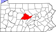
Happy Valley
Pennsylvania State University
The Pennsylvania State University, commonly referred to as Penn State or PSU, is a public research university with campuses and facilities throughout the state of Pennsylvania, United States. Founded in 1855, the university has a threefold mission of teaching, research, and public service...
is located in the valley.
Consisting of the following county:
- CentreCentre County, PennsylvaniaCentre County is a county located in the U.S. state of Pennsylvania. It is part of the State College, Pennsylvania Metropolitan Statistical Area. As of 2010, the population was 153,990....
Cumberland Valley
Consisting of the following counties:
- CumberlandCumberland County, PennsylvaniaCumberland County is a county located in the U.S. state of Pennsylvania and is one of three counties comprising the Harrisburg–Carlisle Metropolitan Statistical Area. As of 2010, the population was 235,406.-History:...
- FranklinFranklin County, PennsylvaniaAs of the census of 2000, there were 129,313 people, 50,633 households, and 36,405 families residing in the county. The population density was 168 people per square mile . There were 53,803 housing units at an average density of 70 per square mile...
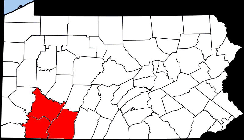
Laurel Highlands
Allegheny Mountains
The Allegheny Mountain Range , also spelled Alleghany, Allegany and, informally, the Alleghenies, is part of the vast Appalachian Mountain Range of the eastern United States and Canada...
.
Consisting of the following counties:
- FayetteFayette County, PennsylvaniaFayette County is a county located in the U.S. state of Pennsylvania. As of the2010 census, the population was 136,606. The county is part of the Pittsburgh Metropolitan Statistical Area....
- SomersetSomerset County, PennsylvaniaSomerset County is a county located in the state of Pennsylvania. As of 2010, the population was 77,742. Somerset County was created on April 17, 1795, from part of Bedford County and named for Somerset, United Kingdom. Its county seat is Somerset. It is part of the Johnstown, Pennsylvania,...
- WestmorelandWestmoreland County, Pennsylvania-Demographics:As of the census of 2000, there were 369,993 people, 149,813 households, and 104,569 families residing in the county. The population density was 361 people per square mile . There were 161,058 housing units at an average density of 157 per square mile...
Pittsburgh Metro Area
- AlleghenyAllegheny County, PennsylvaniaAllegheny County is a county in the southwestern part of the U.S. state of Pennsylvania. As of the 2010 census, the population was 1,223,348; making it the second most populous county in Pennsylvania, following Philadelphia County. The county seat is Pittsburgh...
- ArmstrongArmstrong County, PennsylvaniaArmstrong County is a county located in the U.S. state of Pennsylvania. As of the 2010 census, the population was 68,941. It is located northeast of Pittsburgh and Allegheny County. Armstrong County was added to the Pittsburgh Metropolitan Statistical Area in 2003.The county seat is Kittanning...
- BeaverBeaver County, Pennsylvania-Demographics:As of the census of 2000, there were 181,412 people, 72,576 households, and 50,512 families residing in the county. The population density was 418 people per square mile . There were 77,765 housing units at an average density of 179 per square mile...
- ButlerButler County, Pennsylvania-Demographics:As of the census of 2000, there were 174,083 people, 65,862 households, and 46,827 families residing in the county. The population density was 221 people per square mile . There were 69,868 housing units at an average density of 89 per square mile...
- WashingtonWashington County, Pennsylvania-Government and politics:As of November 2008, there are 152,534 registered voters in Washington County .* Democratic: 89,027 * Republican: 49,025 * Other Parties: 14,482...
- WestmorelandWestmoreland County, Pennsylvania-Demographics:As of the census of 2000, there were 369,993 people, 149,813 households, and 104,569 families residing in the county. The population density was 361 people per square mile . There were 161,058 housing units at an average density of 157 per square mile...
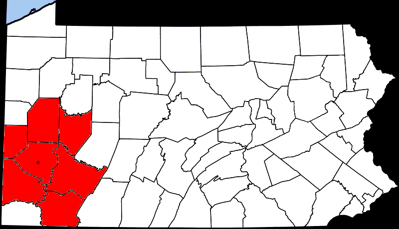
Allegheny National Forest
Consisting of the following counties:
- ForestForest County, PennsylvaniaForest County is a county located in the U.S. state of Pennsylvania. As of 2010, the population is 7,716. Forest County is famous as a rural retreat. Nearly 75% of all dwellings in the county are second or vacation homes . Forest County does not have a single traffic light, the only county in the...
- ElkElk County, PennsylvaniaElk County is a county located in the U.S. state of Pennsylvania. As of the 2010 census, the population was 31,946.Elk County was created on April 18, 1843, from parts of Jefferson, Clearfield and McKean Counties, and is named for the Eastern elk that historically inhabited the region. Its county...
- WarrenWarren County, PennsylvaniaWarren County is a county located in the U.S. state of Pennsylvania. As of 2010, the population was 41,815. It was formed in 1800 from parts of Allegheny and Lycoming counties; attached to Crawford County until 1805 and then to Venango County until Warren was formally organized in 1819. Its county...
- McKeanMcKean County, PennsylvaniaAs of the census of 2000, there were 45,936 people, 18,024 households, and 12,094 families residing in the county. The population density was 47 people per square mile . There were 21,644 housing units at an average density of 22 per square mile...
Pennsylvania's Northwest Region
- ErieErie County, PennsylvaniaErie County is a county located in the U.S. state of Pennsylvania. As of 2010, the population was 280,566. Its county seat is the City of Erie.- Geography :...
- CrawfordCrawford County, PennsylvaniaCrawford County is a county located in the U.S. state of Pennsylvania. As of 2010, the population was 88,765.Crawford County was created on March 12, 1800, from part of Allegheny County and named for Colonel William Crawford...
- MercerMercer County, PennsylvaniaMercer County is a county located in the U.S. state of Pennsylvania. As of 2010, the population was 116,638. Its county seat is Mercer; Sharon is its largest city....
- VenangoVenango County, PennsylvaniaVenango County is a county located in the U.S. state of Pennsylvania. As of the 2010 census, the population was 54,984. Its county seat is Franklin.-History:Venango County was created on March 12, 1800 from parts of Allegheny and Lycoming Counties...
- WarrenWarren County, PennsylvaniaWarren County is a county located in the U.S. state of Pennsylvania. As of 2010, the population was 41,815. It was formed in 1800 from parts of Allegheny and Lycoming counties; attached to Crawford County until 1805 and then to Venango County until Warren was formally organized in 1819. Its county...
- LawrenceLawrence County, PennsylvaniaLawrence County is a county located in the U.S. state of Pennsylvania. In 2010, its population was 91,108. The county was added to the Pittsburgh Metropolitan Statistical Area in 2003. The county seat is New Castle....
- ButlerButler County, Pennsylvania-Demographics:As of the census of 2000, there were 174,083 people, 65,862 households, and 46,827 families residing in the county. The population density was 221 people per square mile . There were 69,868 housing units at an average density of 89 per square mile...
- ClarionClarion County, PennsylvaniaAs of the census of 2000, there were 41,765 people, 16,052 households, and 10,738 families residing in the county. The population density was 69 people per square mile . There were 19,426 housing units at an average density of 32 per square mile...
- ForestForest County, PennsylvaniaForest County is a county located in the U.S. state of Pennsylvania. As of 2010, the population is 7,716. Forest County is famous as a rural retreat. Nearly 75% of all dwellings in the county are second or vacation homes . Forest County does not have a single traffic light, the only county in the...