
Warren County, Pennsylvania
Encyclopedia
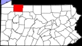
Warren County is a county
located in the U.S. state
of Pennsylvania
. As of 2010, the population was 41,815. It was formed in 1800 from parts of Allegheny
and Lycoming
counties; attached to Crawford County
until 1805 and then to Venango County
until Warren was formally organized in 1819. Its county seat
is Warren
.
, the county has a total area of 898 square miles (2,325 km²), of which 883 square miles (2,288 km²) is land and 14 square miles (37 km²) (1.60%) is water. Notable physical features include the Allegheny River
, the Allegheny Reservoir
, the Kinzua Dam
, and the Allegheny National Forest
.
Warren County is one of only eight counties statewide that border or touch up to eight counties.
National protected area
of 2000, there were 43,863 people, 17,696 households, and 12,121 families residing in the county. The population density
was 50 people per square mile (19/km²). There were 23,058 housing units at an average density of 26 per square mile (10/km²). The racial makeup of the county was 98.68% White
, 0.21% Black
or African American
, 0.19% Native American
, 0.27% Asian
, 0.02% Pacific Islander
, 0.12% from other races
, and 0.52% from two or more races. 0.34% of the population were Hispanic
or Latino
of any race. 22.2% were of German, 12.4% Swedish, 11.2% American
, 10.5% Irish
, 8.8% English
, 8.2% Italian
and 5.1% Polish ancestry according to Census 2000.
There were 17,696 households out of which 29.80% had children under the age of 18 living with them, 56.10% were married couples
living together, 8.40% had a female householder with no husband present, and 31.50% were non-families. 27.20% of all households were made up of individuals and 12.20% had someone living alone who was 65 years of age or older. The average household size was 2.42 and the average family size was 2.93.
In the county, the population was spread out with 24.10% under the age of 18, 6.40% from 18 to 24, 27.00% from 25 to 44, 25.90% from 45 to 64, and 16.70% who were 65 years of age or older. The median age was 40 years. For every 100 females there were 96.20 males. For every 100 females age 18 and over, there were 92.80 males.
 Under Pennsylvania law, there are four types of incorporated municipalities: cities, boroughs, townships, and, in at most two cases, towns. The following cities, boroughs and townships are located in Warren County:
s are geographical areas designated by the U.S. Census Bureau
for the purposes of compiling demographic data. They are not actual jurisdictions under Pennsylvania law.
is adjacent to Allegheny National Forest
and State Game Land 29 just of U.S. Route 6
, near Clarendon
. Warren County also contains a tract of old-growth forest called Hearts Content National Scenic Area
.
County (United States)
In the United States, a county is a geographic subdivision of a state , usually assigned some governmental authority. The term "county" is used in 48 of the 50 states; Louisiana is divided into parishes and Alaska into boroughs. Parishes and boroughs are called "county-equivalents" by the U.S...
located in the U.S. state
U.S. state
A U.S. state is any one of the 50 federated states of the United States of America that share sovereignty with the federal government. Because of this shared sovereignty, an American is a citizen both of the federal entity and of his or her state of domicile. Four states use the official title of...
of Pennsylvania
Pennsylvania
The Commonwealth of Pennsylvania is a U.S. state that is located in the Northeastern and Mid-Atlantic regions of the United States. The state borders Delaware and Maryland to the south, West Virginia to the southwest, Ohio to the west, New York and Ontario, Canada, to the north, and New Jersey to...
. As of 2010, the population was 41,815. It was formed in 1800 from parts of Allegheny
Allegheny County, Pennsylvania
Allegheny County is a county in the southwestern part of the U.S. state of Pennsylvania. As of the 2010 census, the population was 1,223,348; making it the second most populous county in Pennsylvania, following Philadelphia County. The county seat is Pittsburgh...
and Lycoming
Lycoming County, Pennsylvania
-Appalachian Mountains and Allegheny Plateau:Lycoming County is divided between the Appalachian Mountains in the south, the dissected Allegheny Plateau in the north and east, and the valley of the West Branch Susquehanna River between these.-West Branch Susquehanna River:The West Branch of the...
counties; attached to Crawford County
Crawford County, Pennsylvania
Crawford County is a county located in the U.S. state of Pennsylvania. As of 2010, the population was 88,765.Crawford County was created on March 12, 1800, from part of Allegheny County and named for Colonel William Crawford...
until 1805 and then to Venango County
Venango County, Pennsylvania
Venango County is a county located in the U.S. state of Pennsylvania. As of the 2010 census, the population was 54,984. Its county seat is Franklin.-History:Venango County was created on March 12, 1800 from parts of Allegheny and Lycoming Counties...
until Warren was formally organized in 1819. Its county seat
County seat
A county seat is an administrative center, or seat of government, for a county or civil parish. The term is primarily used in the United States....
is Warren
Warren, Pennsylvania
Warren is a city in Warren County, Pennsylvania, United States, located along the Allegheny River. The population was 9,710 at the 2010 census. It is the county seat of Warren County. It is home to the headquarters of the Allegheny National Forest and the Cornplanter State Forest...
.
Geography
According to the U.S. Census BureauUnited States Census Bureau
The United States Census Bureau is the government agency that is responsible for the United States Census. It also gathers other national demographic and economic data...
, the county has a total area of 898 square miles (2,325 km²), of which 883 square miles (2,288 km²) is land and 14 square miles (37 km²) (1.60%) is water. Notable physical features include the Allegheny River
Allegheny River
The Allegheny River is a principal tributary of the Ohio River; it is located in the Eastern United States. The Allegheny River joins with the Monongahela River to form the Ohio River at the "Point" of Point State Park in Downtown Pittsburgh, Pennsylvania...
, the Allegheny Reservoir
Allegheny Reservoir
The Allegheny Reservoir is a reservoir along the Allegheny River in Pennsylvania and New York, USA. It was created in 1965 by the construction of the Kinzua Dam along the river.-History:...
, the Kinzua Dam
Kinzua Dam
The Kinzua Dam, in the Allegheny National Forest in Warren County, Pennsylvania, is one of the largest dams in the United States east of the Mississippi River....
, and the Allegheny National Forest
Allegheny National Forest
The Allegheny National Forest is a National Forest located in northwestern Pennsylvania. The forest covers of land. Within the forest is Kinzua Dam, which impounds the Allegheny River to form Allegheny Reservoir. The administrative headquarters for the Allegheny National Forest is located in Warren...
.
Adjacent counties
- Chautauqua County, New YorkChautauqua County, New York-Major highways:* Interstate 86/New York State Route 17 * Interstate 90 * U.S. Route 20* U.S. Route 62* New York State Route 5* New York State Route 39* New York State Route 60* New York State Route 394...
(north) - Cattaraugus County, New YorkCattaraugus County, New YorkCattaraugus County is a county located in the U.S. state of New York. As of the 2010 census, the population was 80,317. The county seat is Little Valley.-History:...
(northeast) - McKean CountyMcKean County, PennsylvaniaAs of the census of 2000, there were 45,936 people, 18,024 households, and 12,094 families residing in the county. The population density was 47 people per square mile . There were 21,644 housing units at an average density of 22 per square mile...
(east) - Elk CountyElk County, PennsylvaniaElk County is a county located in the U.S. state of Pennsylvania. As of the 2010 census, the population was 31,946.Elk County was created on April 18, 1843, from parts of Jefferson, Clearfield and McKean Counties, and is named for the Eastern elk that historically inhabited the region. Its county...
(southeast) - Forest CountyForest County, PennsylvaniaForest County is a county located in the U.S. state of Pennsylvania. As of 2010, the population is 7,716. Forest County is famous as a rural retreat. Nearly 75% of all dwellings in the county are second or vacation homes . Forest County does not have a single traffic light, the only county in the...
(south) - Venango CountyVenango County, PennsylvaniaVenango County is a county located in the U.S. state of Pennsylvania. As of the 2010 census, the population was 54,984. Its county seat is Franklin.-History:Venango County was created on March 12, 1800 from parts of Allegheny and Lycoming Counties...
(southwest) - Crawford CountyCrawford County, PennsylvaniaCrawford County is a county located in the U.S. state of Pennsylvania. As of 2010, the population was 88,765.Crawford County was created on March 12, 1800, from part of Allegheny County and named for Colonel William Crawford...
(west) - Erie CountyErie County, PennsylvaniaErie County is a county located in the U.S. state of Pennsylvania. As of 2010, the population was 280,566. Its county seat is the City of Erie.- Geography :...
(west)
Warren County is one of only eight counties statewide that border or touch up to eight counties.
National protected areaProtected areaProtected areas are locations which receive protection because of their recognised natural, ecological and/or cultural values. There are several kinds of protected areas, which vary by level of protection depending on the enabling laws of each country or the regulations of the international...
- Allegheny National ForestAllegheny National ForestThe Allegheny National Forest is a National Forest located in northwestern Pennsylvania. The forest covers of land. Within the forest is Kinzua Dam, which impounds the Allegheny River to form Allegheny Reservoir. The administrative headquarters for the Allegheny National Forest is located in Warren...
(part) - Allegheny National Recreation AreaAllegheny National Recreation AreaThe Allegheny National Recreation Area is a National Recreation Area of the United States. It is located in northwestern Pennsylvania, and is administered by the United States Forest Service as part of the Allegheny National Forest. The Area consists of on three separate parcels of land within...
(part)
Demographics
As of the censusCensus
A census is the procedure of systematically acquiring and recording information about the members of a given population. It is a regularly occurring and official count of a particular population. The term is used mostly in connection with national population and housing censuses; other common...
of 2000, there were 43,863 people, 17,696 households, and 12,121 families residing in the county. The population density
Population density
Population density is a measurement of population per unit area or unit volume. It is frequently applied to living organisms, and particularly to humans...
was 50 people per square mile (19/km²). There were 23,058 housing units at an average density of 26 per square mile (10/km²). The racial makeup of the county was 98.68% White
Race (United States Census)
Race and ethnicity in the United States Census, as defined by the Federal Office of Management and Budget and the United States Census Bureau, are self-identification data items in which residents choose the race or races with which they most closely identify, and indicate whether or not they are...
, 0.21% Black
Race (United States Census)
Race and ethnicity in the United States Census, as defined by the Federal Office of Management and Budget and the United States Census Bureau, are self-identification data items in which residents choose the race or races with which they most closely identify, and indicate whether or not they are...
or African American
Race (United States Census)
Race and ethnicity in the United States Census, as defined by the Federal Office of Management and Budget and the United States Census Bureau, are self-identification data items in which residents choose the race or races with which they most closely identify, and indicate whether or not they are...
, 0.19% Native American
Race (United States Census)
Race and ethnicity in the United States Census, as defined by the Federal Office of Management and Budget and the United States Census Bureau, are self-identification data items in which residents choose the race or races with which they most closely identify, and indicate whether or not they are...
, 0.27% Asian
Race (United States Census)
Race and ethnicity in the United States Census, as defined by the Federal Office of Management and Budget and the United States Census Bureau, are self-identification data items in which residents choose the race or races with which they most closely identify, and indicate whether or not they are...
, 0.02% Pacific Islander
Race (United States Census)
Race and ethnicity in the United States Census, as defined by the Federal Office of Management and Budget and the United States Census Bureau, are self-identification data items in which residents choose the race or races with which they most closely identify, and indicate whether or not they are...
, 0.12% from other races
Race (United States Census)
Race and ethnicity in the United States Census, as defined by the Federal Office of Management and Budget and the United States Census Bureau, are self-identification data items in which residents choose the race or races with which they most closely identify, and indicate whether or not they are...
, and 0.52% from two or more races. 0.34% of the population were Hispanic
Race (United States Census)
Race and ethnicity in the United States Census, as defined by the Federal Office of Management and Budget and the United States Census Bureau, are self-identification data items in which residents choose the race or races with which they most closely identify, and indicate whether or not they are...
or Latino
Race (United States Census)
Race and ethnicity in the United States Census, as defined by the Federal Office of Management and Budget and the United States Census Bureau, are self-identification data items in which residents choose the race or races with which they most closely identify, and indicate whether or not they are...
of any race. 22.2% were of German, 12.4% Swedish, 11.2% American
United States
The United States of America is a federal constitutional republic comprising fifty states and a federal district...
, 10.5% Irish
Irish people
The Irish people are an ethnic group who originate in Ireland, an island in northwestern Europe. Ireland has been populated for around 9,000 years , with the Irish people's earliest ancestors recorded having legends of being descended from groups such as the Nemedians, Fomorians, Fir Bolg, Tuatha...
, 8.8% English
English people
The English are a nation and ethnic group native to England, who speak English. The English identity is of early mediaeval origin, when they were known in Old English as the Anglecynn. England is now a country of the United Kingdom, and the majority of English people in England are British Citizens...
, 8.2% Italian
Italian people
The Italian people are an ethnic group that share a common Italian culture, ancestry and speak the Italian language as a mother tongue. Within Italy, Italians are defined by citizenship, regardless of ancestry or country of residence , and are distinguished from people...
and 5.1% Polish ancestry according to Census 2000.
There were 17,696 households out of which 29.80% had children under the age of 18 living with them, 56.10% were married couples
Marriage
Marriage is a social union or legal contract between people that creates kinship. It is an institution in which interpersonal relationships, usually intimate and sexual, are acknowledged in a variety of ways, depending on the culture or subculture in which it is found...
living together, 8.40% had a female householder with no husband present, and 31.50% were non-families. 27.20% of all households were made up of individuals and 12.20% had someone living alone who was 65 years of age or older. The average household size was 2.42 and the average family size was 2.93.
In the county, the population was spread out with 24.10% under the age of 18, 6.40% from 18 to 24, 27.00% from 25 to 44, 25.90% from 45 to 64, and 16.70% who were 65 years of age or older. The median age was 40 years. For every 100 females there were 96.20 males. For every 100 females age 18 and over, there were 92.80 males.
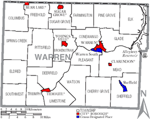
Municipalities
Boroughs
|
Tidioute, Pennsylvania Tidioute is a borough in Warren County, Pennsylvania, United States. The population was 792 at the 2000 census. The name is an Iroquoian word meaning "protrusion of land", referring to a sharp bend in the Allegheny River.-Geography:... Youngsville, Pennsylvania Youngsville is a borough in Warren County, Pennsylvania, United States. The population was 1,834 at the 2000 census.-Geography:Youngsville is located at .... |
Townships
|
Farmington Township, Warren County, Pennsylvania Farmington Township is a township in Warren County, Pennsylvania, United States. The population was 1,353 at the 2000 census.-Geography:According to the United States Census Bureau, the township has a total area of , of which, of it is land and of it is water.-Demographics:As of the census of... Limestone Township, Warren County, Pennsylvania Limestone Township is a township in Warren County, Pennsylvania, USA. The population was 418 at the 2000 census.-Geography:According to the United States Census Bureau, the township has a total area of , of which, of it is land and of it is water.-Demographics:As of the census of 2000, there... Pine Grove Township, Warren County, Pennsylvania Pine Grove Township is a township in Warren County, Pennsylvania, in the United States. As of the 2000 census, the township population was 2,712.-Geography:... |
Spring Creek Township, Warren County, Pennsylvania Spring Creek Township is a township in Warren County, Pennsylvania, United States. The population was 872 at the 2000 census.-Geography:According to the United States Census Bureau, the township has a total area of 48.8 square miles , of which, 48.7 square miles of it is land and... Sugar Grove Township, Warren County, Pennsylvania Sugar Grove Township is a township in Warren County, Pennsylvania, United States. The population was 1,870 at the 2000 census.-Geography:According to the United States Census Bureau, the township has a total area of 35.5 square miles , of which, 35.5 square miles of it is land and... Watson Township, Warren County, Pennsylvania Watson Township is a township in Warren County, Pennsylvania, United States. The population was 322 at the 2000 census.-Geography:According to the United States Census Bureau, the township has a total area of 49.9 square miles , of which, 49.6 square miles of it is land and... |
Census-designated places
Census-designated placeCensus-designated place
A census-designated place is a concentration of population identified by the United States Census Bureau for statistical purposes. CDPs are delineated for each decennial census as the statistical counterparts of incorporated places such as cities, towns and villages...
s are geographical areas designated by the U.S. Census Bureau
United States Census Bureau
The United States Census Bureau is the government agency that is responsible for the United States Census. It also gathers other national demographic and economic data...
for the purposes of compiling demographic data. They are not actual jurisdictions under Pennsylvania law.
- SheffieldSheffield, PennsylvaniaSheffield is a census-designated place in Warren County, Pennsylvania, United States. The population was 1,268 at the 2000 census.-Geography:Sheffield is located at ....
- Warren SouthWarren South, PennsylvaniaWarren South is a census-designated place in Warren County, Pennsylvania, United States. The population was 1,651 at the 2000 census.-Geography:Warren South is located at ....
Other communities
Some communities are neither incorporated nor treated as census-designated places.- AkeleyAkeley, PennsylvaniaAkeley is an unincorporated community in Pine Grove Township, Warren County, Pennsylvania, United States. The community is due north of the similar community of Russell....
- LanderLander, PennsylvaniaLander is a small unincorporated community in Farmington Township in Warren County, Pennsylvania. The border town is located on Pennsylvania Route 957 to the east of the borough of Sugar Grove and to the west of the similar unincorporated community of Russell....
- RussellRussell, PennsylvaniaRussell is an unincorporated community in Pine Grove Township, Warren County, Pennsylvania, United States. The community is due east of the similar hamlet of Lander and lies at the intersection of U.S. Route 62 and Pennsylvania Route 957. It is drained by Conewango Creek.Despite not being...
- TorpedoTorpedo, PennsylvaniaTorpedo is a village located on Pennsylvania Route 27 in Pittsfield Township, Warren County in the U.S. state of Pennsylvania. The village got its unusual name from an incident involving torpedoes used in oil wells to increase the flow of oil, which contained unstable nitroglycerin.- History...
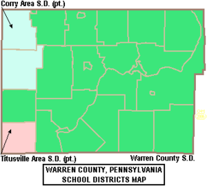
Public School Districts
- Corry Area School DistrictCorry Area School DistrictThe Corry Area School District spans portions of three counties. In Crawford County it covers the Borough of Spartansburg and Sparta Township. In Erie County it covers the City of Corry, the Borough of Elgin and Concord Township and Wayne Township. In Warren County it covers Columbus Township and...
- Titusville Area School DistrictTitusville Area School DistrictThe Titusville Area School District is a small, rural public school district located in Titusville, Pennsylvania.The School District comprises Allegheny Township, Cherrytree Township, Oilcreek Township and Pleasantville Borough located in Venango County; and Centerville Borough, Hydetown Borough,...
- Warren County School DistrictWarren County School DistrictThe Warren County School District is a public school district in Warren County, Pennsylvania, and it is designed to encompass all but three county municipalities. It has four attendance areas: North, East, West and Central. Warren County School District encompasses approximately 792 square miles....
(four high schools)
Recreation
There is one Pennsylvania state park in Warren County. Chapman State ParkChapman State Park
Chapman State Park is a Pennsylvania state park in Pleasant Township, Warren County, Pennsylvania near Clarendon, in the United States. The man-made Chapman Lake covers of the park. Chapman State Park is named in honor of Dr. Leroy E. Chapman. Dr. Chapman was a state senator from 1929 until 1963...
is adjacent to Allegheny National Forest
Allegheny National Forest
The Allegheny National Forest is a National Forest located in northwestern Pennsylvania. The forest covers of land. Within the forest is Kinzua Dam, which impounds the Allegheny River to form Allegheny Reservoir. The administrative headquarters for the Allegheny National Forest is located in Warren...
and State Game Land 29 just of U.S. Route 6
U.S. Route 6 in Pennsylvania
U.S. Route 6 travels east–west near the north edge of the U.S. state of Pennsylvania from the Ohio state line near Pymatuning Reservoir east to the Mid-Delaware Bridge over the Delaware River into Port Jervis, New York. It is the longest highway segment in the Commonwealth. Most of it is a...
, near Clarendon
Clarendon, Pennsylvania
Clarendon is a borough in Warren County, Pennsylvania, United States. The population was 564 at the 2000 census.-Geography:Clarendon is located at ....
. Warren County also contains a tract of old-growth forest called Hearts Content National Scenic Area
Hearts Content National Scenic Area
Hearts Content National Scenic Area is a tract of old-growth forest in Warren County, northwestern Pennsylvania. It represents one of the few remaining old-growth forests in the northeastern United States that contain white pine...
.
See also
- Hickory Creek WildernessHickory Creek WildernessThe Hickory Creek Wilderness is a wilderness area located on the Bradford Ranger District of the Allegheny National Forest in Warren County, Pennsylvania.-Topography:...
- List of municipal authorities in Warren County, Pennsylvania
- National Register of Historic Places listings in Warren County, PennsylvaniaNational Register of Historic Places listings in Warren County, PennsylvaniaThis is a list of the National Register of Historic Places listings in Warren County, Pennsylvania.This is intended to be a complete list of the properties and districts on the National Register of Historic Places in Warren County, Pennsylvania, United States...