
Juniata County, Pennsylvania
Encyclopedia
Juniata County is a county
located in the U.S. state
of Pennsylvania
. As of 2010, the population was 24,636. Juniata County was created on March 2, 1831, from part of Mifflin County
and named for the Juniata River
. Its county seat
is Mifflintown
.
, the county has a total area of 394 square miles (1,020.5 km²), of which 392 square miles (1,015.3 km²) is land and 2 square miles (5.2 km²) (0.50%) is water.
of 2000, there were 22,821 people, 8,584 households, and 6,463 families residing in the county. The population density
was 58 people per square mile (22/km²). There were 10,031 housing units at an average density of 26 per square mile (10/km²). The racial makeup of the county was 98.05% White
, 0.37% Black
or African American
, 0.14% Native American
, 0.25% Asian
, 0.17% Pacific Islander
, 0.50% from other races
, and 0.51% from two or more races. 1.62% of the population were Hispanic
or Latino
of any race. 45.4% were of German, 20.2% American
, 5.7% Irish
and 5.0% English
ancestry according to Census 2000. 3.95% reported speaking Pennsylvania German
, German
, or Dutch
at home; 1.63% speak Spanish
.
There were 8,584 households out of which 33.00% had children under the age of 18 living with them, 64.60% were married couples
living together, 6.30% had a female householder with no husband present, and 24.70% were non-families. 21.10% of all households were made up of individuals and 10.50% had someone living alone who was 65 years of age or older. The average household size was 2.60 and the average family size was 3.01.
In the county, the population was spread out with 25.00% under the age of 18, 8.00% from 18 to 24, 28.10% from 25 to 44, 23.80% from 45 to 64, and 15.20% who were 65 years of age or older. The median age was 38 years. For every 100 females there were 99.00 males. For every 100 females age 18 and over, there were 96.40 males.
is the dominant speech pattern in Juniata County.
There are many immigrant workers in Juniata County from Latin America and South-East Asia who moved to the area to work for Empire Kosher Poultry, the county's largest employer. Most of these immigrants speak Spanish or some other language of their first language. These immigrants speak English with varying degrees of fluency.
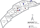
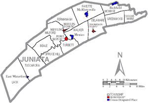 Under Pennsylvania law, there are four types of incorporated municipalities: cities, boroughs, townships, and, in at most two cases, towns. The following boroughs and townships are located in Juniata County:
s are geographical areas designated by the U.S. Census Bureau
for the purposes of compiling demographic data. They are not actual jurisdictions under Pennsylvania law. Other unincorporated communities, such as villages, may be listed here as well.
at 278 feet portal to portal is the longest remaining covered bridge in Pennsylvania, crossing the Tuscarora Creek between Spruce Hill and Beale Townships. Owned by the Juniata County Historical Society, Mifflintown, since 1962, it is listed on the National Register of Historic Places
.
County (United States)
In the United States, a county is a geographic subdivision of a state , usually assigned some governmental authority. The term "county" is used in 48 of the 50 states; Louisiana is divided into parishes and Alaska into boroughs. Parishes and boroughs are called "county-equivalents" by the U.S...
located in the U.S. state
U.S. state
A U.S. state is any one of the 50 federated states of the United States of America that share sovereignty with the federal government. Because of this shared sovereignty, an American is a citizen both of the federal entity and of his or her state of domicile. Four states use the official title of...
of Pennsylvania
Pennsylvania
The Commonwealth of Pennsylvania is a U.S. state that is located in the Northeastern and Mid-Atlantic regions of the United States. The state borders Delaware and Maryland to the south, West Virginia to the southwest, Ohio to the west, New York and Ontario, Canada, to the north, and New Jersey to...
. As of 2010, the population was 24,636. Juniata County was created on March 2, 1831, from part of Mifflin County
Mifflin County, Pennsylvania
Mifflin County is a county located in the U.S. state of Pennsylvania. As of 2010, the population was 46,682. Its county seat is Lewistown. It is named after Thomas Mifflin, the first Governor of Pennsylvania.-Geography:...
and named for the Juniata River
Juniata River
The Juniata River is a tributary of the Susquehanna River, approximately long, in central Pennsylvania in the United States. The river is considered scenic along much of its route, having a broad and shallow course passing through several mountain ridges and steeply-lined water gaps...
. Its county seat
County seat
A county seat is an administrative center, or seat of government, for a county or civil parish. The term is primarily used in the United States....
is Mifflintown
Mifflintown, Pennsylvania
Mifflintown is a borough in and the county seat of Juniata County, Pennsylvania, United States. The population was 861 at the 2000 census.-Geography:Mifflintown is located at ....
.
Geography
According to the U.S. Census BureauUnited States Census Bureau
The United States Census Bureau is the government agency that is responsible for the United States Census. It also gathers other national demographic and economic data...
, the county has a total area of 394 square miles (1,020.5 km²), of which 392 square miles (1,015.3 km²) is land and 2 square miles (5.2 km²) (0.50%) is water.
Adjacent counties
- Snyder CountySnyder County, PennsylvaniaSnyder County is a county located in the U.S. state of Pennsylvania. As of 2010, the population was 39,702. Snyder County was formed in 1855 from parts of Union County...
(north) - Northumberland CountyNorthumberland County, PennsylvaniaThere were 38,835 households out of which 27.30% had children under the age of 18 living with them, 52.40% were married couples living together, 9.60% had a female householder with no husband present, and 34.10% were non-families. 30.20% of all households were made up of individuals and 15.50% had...
(east) - Dauphin CountyDauphin County, PennsylvaniaDauphin County is a county in the U.S. state of Pennsylvania and is one of the three counties comprising the Harrisburg–Carlisle Metropolitan Statistical Area. As of 2010 census, the population was 268,100. The county includes the city of Harrisburg, which has served as the state capital...
(southeast) - Perry CountyPerry County, PennsylvaniaAs of the census of 2000, there were 43,602 people, 16,695 households, and 12,320 families residing in the county. The population density was 79 people per square mile . There were 18,941 housing units at an average density of 34 per square mile...
(south) - Franklin CountyFranklin County, PennsylvaniaAs of the census of 2000, there were 129,313 people, 50,633 households, and 36,405 families residing in the county. The population density was 168 people per square mile . There were 53,803 housing units at an average density of 70 per square mile...
(southwest) - Huntingdon CountyHuntingdon County, PennsylvaniaHuntingdon County is a county located in the U.S. state of Pennsylvania. In 2010, its population was 45,913.Huntingdon County was created on September 20, 1787, from part of Bedford County. Its county seat is Huntingdon.-Geography:According to the U.S...
(west) - Mifflin CountyMifflin County, PennsylvaniaMifflin County is a county located in the U.S. state of Pennsylvania. As of 2010, the population was 46,682. Its county seat is Lewistown. It is named after Thomas Mifflin, the first Governor of Pennsylvania.-Geography:...
(northwest)
Demographics
As of the censusCensus
A census is the procedure of systematically acquiring and recording information about the members of a given population. It is a regularly occurring and official count of a particular population. The term is used mostly in connection with national population and housing censuses; other common...
of 2000, there were 22,821 people, 8,584 households, and 6,463 families residing in the county. The population density
Population density
Population density is a measurement of population per unit area or unit volume. It is frequently applied to living organisms, and particularly to humans...
was 58 people per square mile (22/km²). There were 10,031 housing units at an average density of 26 per square mile (10/km²). The racial makeup of the county was 98.05% White
Race (United States Census)
Race and ethnicity in the United States Census, as defined by the Federal Office of Management and Budget and the United States Census Bureau, are self-identification data items in which residents choose the race or races with which they most closely identify, and indicate whether or not they are...
, 0.37% Black
Race (United States Census)
Race and ethnicity in the United States Census, as defined by the Federal Office of Management and Budget and the United States Census Bureau, are self-identification data items in which residents choose the race or races with which they most closely identify, and indicate whether or not they are...
or African American
Race (United States Census)
Race and ethnicity in the United States Census, as defined by the Federal Office of Management and Budget and the United States Census Bureau, are self-identification data items in which residents choose the race or races with which they most closely identify, and indicate whether or not they are...
, 0.14% Native American
Race (United States Census)
Race and ethnicity in the United States Census, as defined by the Federal Office of Management and Budget and the United States Census Bureau, are self-identification data items in which residents choose the race or races with which they most closely identify, and indicate whether or not they are...
, 0.25% Asian
Race (United States Census)
Race and ethnicity in the United States Census, as defined by the Federal Office of Management and Budget and the United States Census Bureau, are self-identification data items in which residents choose the race or races with which they most closely identify, and indicate whether or not they are...
, 0.17% Pacific Islander
Race (United States Census)
Race and ethnicity in the United States Census, as defined by the Federal Office of Management and Budget and the United States Census Bureau, are self-identification data items in which residents choose the race or races with which they most closely identify, and indicate whether or not they are...
, 0.50% from other races
Race (United States Census)
Race and ethnicity in the United States Census, as defined by the Federal Office of Management and Budget and the United States Census Bureau, are self-identification data items in which residents choose the race or races with which they most closely identify, and indicate whether or not they are...
, and 0.51% from two or more races. 1.62% of the population were Hispanic
Race (United States Census)
Race and ethnicity in the United States Census, as defined by the Federal Office of Management and Budget and the United States Census Bureau, are self-identification data items in which residents choose the race or races with which they most closely identify, and indicate whether or not they are...
or Latino
Race (United States Census)
Race and ethnicity in the United States Census, as defined by the Federal Office of Management and Budget and the United States Census Bureau, are self-identification data items in which residents choose the race or races with which they most closely identify, and indicate whether or not they are...
of any race. 45.4% were of German, 20.2% American
United States
The United States of America is a federal constitutional republic comprising fifty states and a federal district...
, 5.7% Irish
Irish people
The Irish people are an ethnic group who originate in Ireland, an island in northwestern Europe. Ireland has been populated for around 9,000 years , with the Irish people's earliest ancestors recorded having legends of being descended from groups such as the Nemedians, Fomorians, Fir Bolg, Tuatha...
and 5.0% English
English people
The English are a nation and ethnic group native to England, who speak English. The English identity is of early mediaeval origin, when they were known in Old English as the Anglecynn. England is now a country of the United Kingdom, and the majority of English people in England are British Citizens...
ancestry according to Census 2000. 3.95% reported speaking Pennsylvania German
Pennsylvania German language
The Pennsylvania German language is a variety of West Central German possibly spoken by more than 250,000 people in North America...
, German
German language
German is a West Germanic language, related to and classified alongside English and Dutch. With an estimated 90 – 98 million native speakers, German is one of the world's major languages and is the most widely-spoken first language in the European Union....
, or Dutch
Dutch language
Dutch is a West Germanic language and the native language of the majority of the population of the Netherlands, Belgium, and Suriname, the three member states of the Dutch Language Union. Most speakers live in the European Union, where it is a first language for about 23 million and a second...
at home; 1.63% speak Spanish
Spanish language
Spanish , also known as Castilian , is a Romance language in the Ibero-Romance group that evolved from several languages and dialects in central-northern Iberia around the 9th century and gradually spread with the expansion of the Kingdom of Castile into central and southern Iberia during the...
.
There were 8,584 households out of which 33.00% had children under the age of 18 living with them, 64.60% were married couples
Marriage
Marriage is a social union or legal contract between people that creates kinship. It is an institution in which interpersonal relationships, usually intimate and sexual, are acknowledged in a variety of ways, depending on the culture or subculture in which it is found...
living together, 6.30% had a female householder with no husband present, and 24.70% were non-families. 21.10% of all households were made up of individuals and 10.50% had someone living alone who was 65 years of age or older. The average household size was 2.60 and the average family size was 3.01.
In the county, the population was spread out with 25.00% under the age of 18, 8.00% from 18 to 24, 28.10% from 25 to 44, 23.80% from 45 to 64, and 15.20% who were 65 years of age or older. The median age was 38 years. For every 100 females there were 99.00 males. For every 100 females age 18 and over, there were 96.40 males.
Accent and Dialect
The Central Pennsylvania accentCentral Pennsylvania accent
Central Pennsylvania speech is closely related to Western Pennsylvania speech, which is generally referred to as Pittsburgh English, although the speech extends beyond just the city of Pittsburgh, and also is closely related to the Southern accent, spoken in the Southeastern United States...
is the dominant speech pattern in Juniata County.
There are many immigrant workers in Juniata County from Latin America and South-East Asia who moved to the area to work for Empire Kosher Poultry, the county's largest employer. Most of these immigrants speak Spanish or some other language of their first language. These immigrants speak English with varying degrees of fluency.
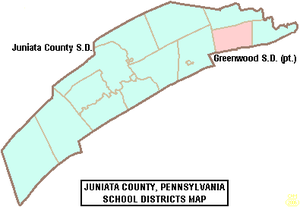
Municipalities
Boroughs
|
Port Royal, Pennsylvania Port Royal is a borough in Juniata County, Pennsylvania, United States. The population was 977 at the 2000 census.- History :Port Royal was originally named Perrysville, after Commodore Oliver Hazard Perry. At the time, the Port Royal post office was located in Saint Tammany town, just across the... Thompsontown, Pennsylvania Thompsontown is a borough in Juniata County, Pennsylvania, United States. The population was 711 at the 2000 census.-History:Thompsontown was founded in 1755 by William Thompson... |
Townships
|
Monroe Township, Juniata County, Pennsylvania Monroe Township is a township in Juniata County, Pennsylvania, United States. The population was 2,042 at the 2000 census.-Geography:According to the United States Census Bureau, the township has a total area of 19.6 square miles , all of it land.Monroe Township is bordered by Snyder County to... Susquehanna Township, Juniata County, Pennsylvania Susquehanna Township is a township in Juniata County, Pennsylvania, United States. The population was 1,261 at the 2000 census.-Geography:According to the United States Census Bureau, the township has a total area of 16.5 square miles , all of it land.Susquehanna Township is bordered by Monroe... Tuscarora Township, Juniata County, Pennsylvania Tuscarora Township is a township in Juniata County, Pennsylvania, United States. The population was 1,159 at the 2000 census.-Geography:According to the United States Census Bureau, the township has a total area of 47.4 square miles , all of it land.Tuscarora Township is bordered by Mifflin... Walker Township, Juniata County, Pennsylvania Walker Township is a township in Juniata County, Pennsylvania, United States. The population was 2,598 at the 2000 census.-Geography:According to the United States Census Bureau, the township has a total area of 29.5 square miles , of which, 29.0 square miles of it is land and... |
Census-designated places
Census-designated placeCensus-designated place
A census-designated place is a concentration of population identified by the United States Census Bureau for statistical purposes. CDPs are delineated for each decennial census as the statistical counterparts of incorporated places such as cities, towns and villages...
s are geographical areas designated by the U.S. Census Bureau
United States Census Bureau
The United States Census Bureau is the government agency that is responsible for the United States Census. It also gathers other national demographic and economic data...
for the purposes of compiling demographic data. They are not actual jurisdictions under Pennsylvania law. Other unincorporated communities, such as villages, may be listed here as well.
|
Mexico, Juniata County, Pennsylvania Mexico is an unincorporated community and census-designated place that is part of Walker Township in Juniata County in the U.S. state of Pennsylvania. The CDP is defined for statistical purposes and has no status as a legal municipality... Richfield, Pennsylvania Richfield is a census-designated place that is part of Monroe Township in Juniata County, Pennsylvania, United States. The population was 459 at the 2000 census.-Geography:Richfield is located at .... |
Villages
- Arch Rock
- Bunkertown
- Tuscarora
- East Salem
- Van Dyke
- Cross Keys
- Licking Creek
- Evendale
- Centre
- Walnut
- Oriental
- Seven Stars
- Pfoutz Valley
- Old Port
- Black Log(Dommers Efficiency)
- Honey Grove
- Van Wert
- Oakland Mills
- Reeds Gap(Partyville)
- Beale(Fred N Walters Home Village)
- Mt. Pleasant
- Spruce Hill
Education
Academia Pomeroy Covered Bridge
Academia Pomeroy Covered BridgeAcademia Pomeroy Covered Bridge
The Academia Pomeroy Covered Bridge at 278 feet is the longest remaining covered bridge in Pennsylvania.Built in 1902, this single-lane, double-span wooden covered bridge crosses Tuscarora Creek between Spruce Hill and Beale Townships, in Juniata County...
at 278 feet portal to portal is the longest remaining covered bridge in Pennsylvania, crossing the Tuscarora Creek between Spruce Hill and Beale Townships. Owned by the Juniata County Historical Society, Mifflintown, since 1962, it is listed on the National Register of Historic Places
National Register of Historic Places
The National Register of Historic Places is the United States government's official list of districts, sites, buildings, structures, and objects deemed worthy of preservation...
.
See also
- List of municipal authorities in Juniata County, Pennsylvania
- National Register of Historic Places listings in Juniata County, PennsylvaniaNational Register of Historic Places listings in Juniata County, PennsylvaniaThis is a list of the National Register of Historic Places listings in Juniata County, Pennsylvania.This is intended to be a complete list of the properties and districts on the National Register of Historic Places in Juniata County, Pennsylvania, United States...
- USS Juniata County (LST-850)USS Juniata County (LST-850)USS LST-850 was an built for the United States Navy during World War II. Late in her career, she was renamed Juniata County —after Juniata County, Pennsylvania, the only U.S...
External links
- [ftp://ftp.dot.state.pa.us/public/pdf/BPR_pdf_files/Maps/GHS/Roadnames/mifflin_GHSN.pdf Pennsylvania Department of Transportation, Bureau of Planning and Research, Geographic Information Division, "2005 General Highway Map of Juniata and Mifflin Counties"] Note: shows boroughs, townships, roads, villages, some streams. URL accessed on April 5, 2006.