
Lawrence County, Pennsylvania
Encyclopedia
Lawrence County is a county
located in the U.S. state
of Pennsylvania
. In 2010, its population was 91,108. The county was added to the Pittsburgh Metropolitan Statistical Area in 2003. The county seat
is New Castle
.
Lawrence County was created on March 20, 1849, from parts of Beaver
and Mercer
counties. It was named after the USS Lawrence
, Oliver Hazard Perry's
original flagship
at the Battle of Lake Erie
during the War of 1812
.
, the county has a total area of 363 square miles (940.2 km²), of which 360 square miles (932.4 km²) is land and 2 square miles (5.2 km²) (0.63%) is water. Major waterways are the Shenango River, Neshannock Creek and the Mahoning River which form the Beaver River. Also, the Slippery Rock Creek and Connoquenessing Creak empty into the Beaver River.
of 2000, there were 94,643 people, 37,091 households, and 25,889 families residing in the county. The population density
was 263 people per square mile (101/km²). There were 39,635 housing units at an average density of 110 per square mile (42/km²). The racial makeup of the county was 94.98% White
, 3.61% Black
or African American
, 0.10% Native American
, 0.27% Asian
, 0.01% Pacific Islander
, 0.19% from other races
, and 0.84% from two or more races. 0.56% of the population were Hispanic
or Latino
of any race. 26.1% were of Italian
, 21.7% German, 9.3% Irish
, 6.8% English
and 6.8% Polish ancestry according to Census 2000.
There were 37,091 households out of which 28.80% had children under the age of 18 living with them, 54.50% were married couples
living together, 11.50% had a female householder with no husband present, and 30.20% were non-families. 27.00% of all households were made up of individuals and 14.40% had someone living alone who was 65 years of age or older. The average household size was 2.47 and the average family size was 3.00.
In the county, the population was spread out with 23.10% under the age of 18, 8.30% from 18 to 24, 25.70% from 25 to 44, 23.60% from 45 to 64, and 19.30% who were 65 years of age or older. The median age was 40 years. For every 100 females there were 90.60 males. For every 100 females age 18 and over, there were 86.90 males.
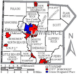 Under Pennsylvania law, there are four types of incorporated municipalities: cities, boroughs, townships, and, in at most two cases, towns. The following cities, boroughs and townships are located in Lawrence County:
s are geographical areas designated by the U.S. Census Bureau
for the purposes of compiling demographic data. They are not actual jurisdictions under Pennsylvania law. Other unincorporated communities, such as villages, may be listed here as well.
County (United States)
In the United States, a county is a geographic subdivision of a state , usually assigned some governmental authority. The term "county" is used in 48 of the 50 states; Louisiana is divided into parishes and Alaska into boroughs. Parishes and boroughs are called "county-equivalents" by the U.S...
located in the U.S. state
U.S. state
A U.S. state is any one of the 50 federated states of the United States of America that share sovereignty with the federal government. Because of this shared sovereignty, an American is a citizen both of the federal entity and of his or her state of domicile. Four states use the official title of...
of Pennsylvania
Pennsylvania
The Commonwealth of Pennsylvania is a U.S. state that is located in the Northeastern and Mid-Atlantic regions of the United States. The state borders Delaware and Maryland to the south, West Virginia to the southwest, Ohio to the west, New York and Ontario, Canada, to the north, and New Jersey to...
. In 2010, its population was 91,108. The county was added to the Pittsburgh Metropolitan Statistical Area in 2003. The county seat
County seat
A county seat is an administrative center, or seat of government, for a county or civil parish. The term is primarily used in the United States....
is New Castle
New Castle, Pennsylvania
New Castle is a city in Lawrence County, Pennsylvania, United States, northwest of Pittsburgh and near the Pennsylvania-Ohio border just east of Youngstown, Ohio; in 1910, the total population was 36,280; in 1920, 44,938; and in 1940, 47,638. The population has fallen to 26,309 according to the...
.
Lawrence County was created on March 20, 1849, from parts of Beaver
Beaver County, Pennsylvania
-Demographics:As of the census of 2000, there were 181,412 people, 72,576 households, and 50,512 families residing in the county. The population density was 418 people per square mile . There were 77,765 housing units at an average density of 179 per square mile...
and Mercer
Mercer County, Pennsylvania
Mercer County is a county located in the U.S. state of Pennsylvania. As of 2010, the population was 116,638. Its county seat is Mercer; Sharon is its largest city....
counties. It was named after the USS Lawrence
USS Lawrence
Five United States Navy ships have borne the name USS Lawrence in honor of James Lawrence. was a brig which acted as Commodore Oliver Perry's flagship during the first part of the Battle of Lake Erie until she became unmanageable in that action....
, Oliver Hazard Perry's
Oliver Hazard Perry
United States Navy Commodore Oliver Hazard Perry was born in South Kingstown, Rhode Island , the son of USN Captain Christopher Raymond Perry and Sarah Wallace Alexander, a direct descendant of William Wallace...
original flagship
Flagship
A flagship is a vessel used by the commanding officer of a group of naval ships, reflecting the custom of its commander, characteristically a flag officer, flying a distinguishing flag...
at the Battle of Lake Erie
Battle of Lake Erie
The Battle of Lake Erie, sometimes called the Battle of Put-in-Bay, was fought on 10 September 1813, in Lake Erie off the coast of Ohio during the War of 1812. Nine vessels of the United States Navy defeated and captured six vessels of Great Britain's Royal Navy...
during the War of 1812
War of 1812
The War of 1812 was a military conflict fought between the forces of the United States of America and those of the British Empire. The Americans declared war in 1812 for several reasons, including trade restrictions because of Britain's ongoing war with France, impressment of American merchant...
.
Geography
According to the U.S. Census BureauUnited States Census Bureau
The United States Census Bureau is the government agency that is responsible for the United States Census. It also gathers other national demographic and economic data...
, the county has a total area of 363 square miles (940.2 km²), of which 360 square miles (932.4 km²) is land and 2 square miles (5.2 km²) (0.63%) is water. Major waterways are the Shenango River, Neshannock Creek and the Mahoning River which form the Beaver River. Also, the Slippery Rock Creek and Connoquenessing Creak empty into the Beaver River.
Adjacent counties
- Mercer CountyMercer County, PennsylvaniaMercer County is a county located in the U.S. state of Pennsylvania. As of 2010, the population was 116,638. Its county seat is Mercer; Sharon is its largest city....
(north) - Butler CountyButler County, Pennsylvania-Demographics:As of the census of 2000, there were 174,083 people, 65,862 households, and 46,827 families residing in the county. The population density was 221 people per square mile . There were 69,868 housing units at an average density of 89 per square mile...
(east) - Beaver CountyBeaver County, Pennsylvania-Demographics:As of the census of 2000, there were 181,412 people, 72,576 households, and 50,512 families residing in the county. The population density was 418 people per square mile . There were 77,765 housing units at an average density of 179 per square mile...
(south) - Columbiana County, OhioColumbiana County, OhioColumbiana County is a county located in the U.S. state of Ohio. As of 2010, the population was 107,841. It is named for Christopher Columbus and the county seat is Lisbon....
(southwest) - Mahoning County, Ohio (west)
Government and politics
As of November 2008, there are 62,505 registered voters in Lawernce County http://www.dos.state.pa.us/elections/lib/elections/055_voter_registration_statistics/currentstats/currentvotestats.xls.- DemocraticDemocratic Party (United States)The Democratic Party is one of two major contemporary political parties in the United States, along with the Republican Party. The party's socially liberal and progressive platform is largely considered center-left in the U.S. political spectrum. The party has the lengthiest record of continuous...
: 34,728 (55.56%) - RepublicanRepublican Party (United States)The Republican Party is one of the two major contemporary political parties in the United States, along with the Democratic Party. Founded by anti-slavery expansion activists in 1854, it is often called the GOP . The party's platform generally reflects American conservatism in the U.S...
: 22,509 (36.01%) - Other Parties: 5,268 (8.43%)
County commissioners
- Dan Vogler, Chairman, Republican
- Bob Del Signore, Republican
- Steve Craig, Democrat
Other county officials
- Clerk of Courts and Prothonotary, Helen Morgan, Democrat
- Controller, David Gettings, Republican
- District Attorney, Joshua Lamancusa, Democrat
- Register of Wills and Recorder of Deeds, Janet Kalajainen, Democrat
- Sheriff, Perry Quahliero, Democrat
- Treasurer, Richard Rapone, Democrat
State Representatives
- Christopher Sainato, Democrat, 9th district
- Jaret GibbonsJaret GibbonsJaret A. Gibbons is a member of the Pennsylvania House of Representatives, representing the 10th legislative district. He was elected in 2006.Prior to elective office, Gibbons graduated from Duquesne University and the University of Pittsburgh School of Law, where he was editor in chief of the...
, Democrat, 10th district - Michele BrooksMichele BrooksMichele Brooks is a member of Pennsylvania House of Representatives for the 17th District and was elected in 2006. In June 2006, Brooks was selected by the local Republican committee to replace the retiring 10-year incumbent Rod Wilt on the ballot....
, Republican, 17th district
State Senators
- Elder VogelElder VogelElder Vogel, Jr. is a Republican member of the Pennsylvania State Senate. He has represented the 47th district since 2009.-Professional career:Vogel is a fourth generation dairy farmer who operates his family's farm in New Sewickley Township....
, Republican, 47th district - Robert D. RobbinsRobert D. RobbinsRobert D. "Bob" Robbins is a Republican member of the Pennsylvania State Senate, representing the 50th District since 1990. He previously served as a member of the Pennsylvania House of Representatives for the 17th District from 1983 to 1990....
, Republican, 50th district
Demographics
As of the censusCensus
A census is the procedure of systematically acquiring and recording information about the members of a given population. It is a regularly occurring and official count of a particular population. The term is used mostly in connection with national population and housing censuses; other common...
of 2000, there were 94,643 people, 37,091 households, and 25,889 families residing in the county. The population density
Population density
Population density is a measurement of population per unit area or unit volume. It is frequently applied to living organisms, and particularly to humans...
was 263 people per square mile (101/km²). There were 39,635 housing units at an average density of 110 per square mile (42/km²). The racial makeup of the county was 94.98% White
Race (United States Census)
Race and ethnicity in the United States Census, as defined by the Federal Office of Management and Budget and the United States Census Bureau, are self-identification data items in which residents choose the race or races with which they most closely identify, and indicate whether or not they are...
, 3.61% Black
Race (United States Census)
Race and ethnicity in the United States Census, as defined by the Federal Office of Management and Budget and the United States Census Bureau, are self-identification data items in which residents choose the race or races with which they most closely identify, and indicate whether or not they are...
or African American
Race (United States Census)
Race and ethnicity in the United States Census, as defined by the Federal Office of Management and Budget and the United States Census Bureau, are self-identification data items in which residents choose the race or races with which they most closely identify, and indicate whether or not they are...
, 0.10% Native American
Race (United States Census)
Race and ethnicity in the United States Census, as defined by the Federal Office of Management and Budget and the United States Census Bureau, are self-identification data items in which residents choose the race or races with which they most closely identify, and indicate whether or not they are...
, 0.27% Asian
Race (United States Census)
Race and ethnicity in the United States Census, as defined by the Federal Office of Management and Budget and the United States Census Bureau, are self-identification data items in which residents choose the race or races with which they most closely identify, and indicate whether or not they are...
, 0.01% Pacific Islander
Race (United States Census)
Race and ethnicity in the United States Census, as defined by the Federal Office of Management and Budget and the United States Census Bureau, are self-identification data items in which residents choose the race or races with which they most closely identify, and indicate whether or not they are...
, 0.19% from other races
Race (United States Census)
Race and ethnicity in the United States Census, as defined by the Federal Office of Management and Budget and the United States Census Bureau, are self-identification data items in which residents choose the race or races with which they most closely identify, and indicate whether or not they are...
, and 0.84% from two or more races. 0.56% of the population were Hispanic
Race (United States Census)
Race and ethnicity in the United States Census, as defined by the Federal Office of Management and Budget and the United States Census Bureau, are self-identification data items in which residents choose the race or races with which they most closely identify, and indicate whether or not they are...
or Latino
Race (United States Census)
Race and ethnicity in the United States Census, as defined by the Federal Office of Management and Budget and the United States Census Bureau, are self-identification data items in which residents choose the race or races with which they most closely identify, and indicate whether or not they are...
of any race. 26.1% were of Italian
Italian people
The Italian people are an ethnic group that share a common Italian culture, ancestry and speak the Italian language as a mother tongue. Within Italy, Italians are defined by citizenship, regardless of ancestry or country of residence , and are distinguished from people...
, 21.7% German, 9.3% Irish
Irish people
The Irish people are an ethnic group who originate in Ireland, an island in northwestern Europe. Ireland has been populated for around 9,000 years , with the Irish people's earliest ancestors recorded having legends of being descended from groups such as the Nemedians, Fomorians, Fir Bolg, Tuatha...
, 6.8% English
English people
The English are a nation and ethnic group native to England, who speak English. The English identity is of early mediaeval origin, when they were known in Old English as the Anglecynn. England is now a country of the United Kingdom, and the majority of English people in England are British Citizens...
and 6.8% Polish ancestry according to Census 2000.
There were 37,091 households out of which 28.80% had children under the age of 18 living with them, 54.50% were married couples
Marriage
Marriage is a social union or legal contract between people that creates kinship. It is an institution in which interpersonal relationships, usually intimate and sexual, are acknowledged in a variety of ways, depending on the culture or subculture in which it is found...
living together, 11.50% had a female householder with no husband present, and 30.20% were non-families. 27.00% of all households were made up of individuals and 14.40% had someone living alone who was 65 years of age or older. The average household size was 2.47 and the average family size was 3.00.
In the county, the population was spread out with 23.10% under the age of 18, 8.30% from 18 to 24, 25.70% from 25 to 44, 23.60% from 45 to 64, and 19.30% who were 65 years of age or older. The median age was 40 years. For every 100 females there were 90.60 males. For every 100 females age 18 and over, there were 86.90 males.
Municipalities
Boroughs
|
New Beaver, Pennsylvania New Beaver is a borough in Lawrence County, Pennsylvania, United States. The population was 1,677 at the 2000 census.-Geography:New Beaver is located at .... New Wilmington, Pennsylvania New Wilmington is a borough in Lawrence County, Pennsylvania, United States, first platted in 1824 and established as a borough on April 9, 1873. The population was 2,452 at the 2000 census... S.N.P.J., Pennsylvania S.N.P.J. is a borough located in Lawrence County, Pennsylvania. According to the 2010 U.S. census, the borough has a population of 19.S.N.P.J... |
South New Castle, Pennsylvania South New Castle is a borough in Lawrence County, Pennsylvania, United States. The population was 808 at the 2000 census. South New Castle is primarily a residential neighborhood which lies south of the southern border of the city of New Castle, Pennsylvania... Volant, Pennsylvania Volant is a borough in Lawrence County, Pennsylvania, United States. The population was 113 at the 2000 census.-History:The land on which the borough of Volant currently sits on was bought from the Native Americans in 1784. The first grist mill was built on the Neshannock Creek in 1806 and was... Wampum, Pennsylvania Wampum is a borough in Lawrence County, Pennsylvania, United States. The population was 678 at the 2000 census.-Geography:Wampum is located at .... |
Townships
|
Pulaski Township, Lawrence County, Pennsylvania Pulaski Township is a township in Lawrence County, Pennsylvania, United States. The population was 3,658 at the 2000 census.- Geography :... Scott Township, Lawrence County, Pennsylvania Scott Township is a township in Lawrence County, Pennsylvania, United States. The population was 2,235 as of the 2000 census.-Geography:According to the United States Census Bureau, the township has a total area of 19.7 square miles , of which, 19.7 square miles of it is land and... Shenango Township, Lawrence County, Pennsylvania Shenango Township is a township in Lawrence County, Pennsylvania, United States. The population was 7,633 at the 2000 census. Shenango Township is situated between the cities of New Castle, Pennsylvania , and Ellwood City, Pennsylvania .-Geography:According to the United States Census Bureau, the... Slippery Rock Township, Lawrence County, Pennsylvania Slippery Rock Township is a township in Lawrence County, Pennsylvania, United States. The population was 3,179 at the 2000 census.-History:... |
Taylor Township, Lawrence County, Pennsylvania Taylor Township is a township in Lawrence County, Pennsylvania, United States. The population was 1,198 at the 2000 census.-Geography:According to the United States Census Bureau, the township has a total area of 5.3 square miles , of which, 5.1 square miles of it is land and... Union Township, Lawrence County, Pennsylvania Union Township is a township in Lawrence County, Pennsylvania, United States. The population was 5,103 at the 2000 census.-Geography:According to the United States Census Bureau, the township has a total area of 9.7 square miles , of which, 9.6 square miles of it is land and... Washington Township, Lawrence County, Pennsylvania Washington Township is a township in Lawrence County, Pennsylvania, United States. The population was 714 at the 2000 census.-Geography:According to the United States Census Bureau, the township has a total area of 16.6 square miles , of which, 16.4 square miles of it is land and... Wayne Township, Lawrence County, Pennsylvania Wayne Township is a township in Lawrence County, Pennsylvania, United States. The population was 2,328 at the 2000 census.-History:The township was linked to New Castle, Ellwood and Pittsburgh in 1908 by the Pittsburgh, Harmony, Butler and New Castle Railway, an interurban trolley line... Wilmington Township, Lawrence County, Pennsylvania Wilmington Township is a township in Lawrence County, Pennsylvania, United States. The population was 2,760 at the 2000 census.Wilmington was established as a township in February 1846 by combining parts of Neshannock Township in Lawrence County with parts of Lackawannock Township in Mercer County... |
Census-designated places
Census-designated placeCensus-designated place
A census-designated place is a concentration of population identified by the United States Census Bureau for statistical purposes. CDPs are delineated for each decennial census as the statistical counterparts of incorporated places such as cities, towns and villages...
s are geographical areas designated by the U.S. Census Bureau
United States Census Bureau
The United States Census Bureau is the government agency that is responsible for the United States Census. It also gathers other national demographic and economic data...
for the purposes of compiling demographic data. They are not actual jurisdictions under Pennsylvania law. Other unincorporated communities, such as villages, may be listed here as well.
- New Castle NorthwestNew Castle Northwest, PennsylvaniaNew Castle Northwest is a census-designated place in Lawrence County, Pennsylvania, United States. The population was 1,535 at the 2000 census.-Geography:New Castle Northwest is located at ....
- OaklandOakland, Lawrence County, PennsylvaniaOakland is a census-designated place in Lawrence County, Pennsylvania, United States. The population was 1,516 at the 2000 census.-Geography:Oakland is located at ....
- OakwoodOakwood, PennsylvaniaOakwood is a census-designated place in Lawrence County, Pennsylvania, United States. The population was 2,249 at the 2000 census.-Geography:Oakwood is located at ....
Other Communities
Various unincorporated communities that lie within and are part of official municipalities.- Castlewood (Shenango Twp)
- Chewton (Wayne Twp)
- Eastbrook (Hickory Twp)
- Edinburg (Mahoning Twp)
- Energy (Slippery Rock Twp)
- Frizzleburg (Pulaski Twp)
- Harlansburg (Scott Twp)
- Hillsville (Mahoning Twp)
- Moravia (Taylor Twp)
- Mount Jackson (North Beaver Twp)
- New Bedford (Pulaski Twp)
- West Pittsburg (Taylor Township)
- Wurtemburg (Taylor Twp)
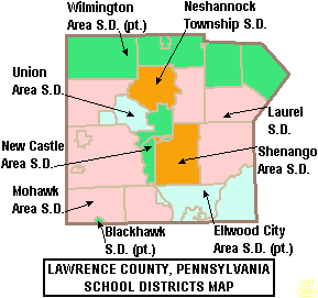
Education
Public School Districts
- Blackhawk School DistrictBlackhawk School DistrictThe Blackhawk School District is a public school district that spans portions of two counties in Pennsylvania. In Beaver County it covers the Boroughs of Darlington, Patterson Heights and West Mayfield and Chippewa Township, Darlington Township, Patterson Township and South Beaver Township. In...
(part) - Ellwood City Area School DistrictEllwood City Area School DistrictThe Elwood City Area School District is a public school district in Beaver County, Pennsylvania and Lawrence County, Pennsylvania. It serves the boroughs of Ellwood City, Ellport, and New Beaver, and the townships of Wayne, and Perry Townships...
(part) - Laurel School DistrictLaurel School District (Pennsylvania)Laurel School District is a public school district located in Lawrence County, Pennsylvania. The district features one elementary school and a combined junior–senior high school. Scott Township, Slippery Rock Township, and Hickory Township are within district boundaries....
- Mohawk Area School DistrictMohawk Area School DistrictMohawk Area School District is a public school system in Bessemer, Lawrence County, Pennsylvania, United States. It is the largest school district in Lawrence County by area, serving the boroughs of Bessemer, New Beaver and SNPJ, as well as the townsips of Mahoning, Little Beaver, and North...
- Neshannock Township School DistrictNeshannock Township School DistrictNeshannock Township School District is a public school district located in Lawrence County, Pennsylvania. The district serves Neshannock Township, Pennsylvania, a community featuring a variety of suburban-style homes...
- New Castle Area School DistrictNew Castle Area School DistrictNew Castle Area School District is a public school district located in Lawrence County, Pennsylvania. The district serves the city of New Castle, plus South New Castle, and Taylor Township. Schools include Croton Pre-Kindergarten, Harry W. Lockley Kindergarten, Thaddeus Stevens Primary, West Side...
- Shenango School DistrictShenango School DistrictShenango Area School District is a public school district located in Lawrence County, Pennsylvania, United States. The district serves Shenango Township and South New Castle Borough...
- Union Area School DistrictUnion Area School DistrictUnion Area School District is a public school district located in Lawrence County, Pennsylvania. The district serves Union Township, Lawrence County, Pennsylvania and the independent district of Edinburg which encompasses portions of several neighbouring counties. The district features one...
- Wilmington Area School DistrictWilmington Area School DistrictWilmington Area School District is a public school district located in Lawrence County, Pennsylvania and Mercer County, Pennsylvania. The district serves the boroughs of New Wilmington and Volant plus Pulaski, Wilmington Township, Washington Township, and Plain Grove Townships in Lawrence County....
(part)
Colleges
- Butler Community College Lawrence Crossing Campus
- Erie Business College
- Westminster CollegeWestminster College, PennsylvaniaWestminster College is a liberal arts college located in New Wilmington, Pennsylvania, United States. Founded in 1852, it is affiliated with the Presbyterian Church...
Major Roads
-
 Interstate 76Interstate 76 (east)Interstate 76 is an Interstate Highway in the United States, running 435 miles from an interchange with Interstate 71 west of Akron, Ohio, east to Interstate 295 near Camden, New Jersey....
 -
 Interstate 79Interstate 79Interstate 79 is an Interstate Highway in the eastern United States, designated from Interstate 77 in Charleston, West Virginia to Pennsylvania Route 5 and Pennsylvania Route 290 in Erie, Pennsylvania...
 -
 Interstate 376Interstate 376Interstate 376 is a major auxiliary route of the Interstate Highway System in the U.S. state of Pennsylvania, located entirely within the Allegheny Plateau. It runs from I-80 near Sharon south and east to a junction with the Pennsylvania Turnpike in Monroeville, after having crossed the Turnpike...
 -
 Pennsylvania Route 18Pennsylvania Route 18Pennsylvania Route 18 is a major north–south highway in Western Pennsylvania whose southern terminus is at the West Virginia state line in Greene County, Pennsylvania near the village of Garrison, while the northern terminus is at PA Route 5 in Lake City, Pennsylvania...
 -
 Pennsylvania Route 65Pennsylvania Route 65Pennsylvania Route 65 is a major state highway located in western Pennsylvania, United States. The route, traveling north–south from the Interstate 279/U.S...
 -
 Pennsylvania Route 388Pennsylvania Route 388Pennsylvania Route 388 is a north–south state highway in Lawrence County, Pennsylvania, United States, located in Western Pennsylvania...
 -
 Pennsylvania Route 551Pennsylvania Route 551Pennsylvania Route 551 is an long state highway located in Beaver, Lawrence, and Mercer counties in Pennsylvania. The southern terminus is at PA 18 in Beaver Falls...
 -
 U.S. Route 19U.S. Route 19U.S. Route 19 is a north–south U.S. Highway. Despite encroaching Interstate Highways, the route has remained a long-haul route, connecting the Gulf of Mexico with Lake Erie....
 -
 U.S. Route 224U.S. Route 224U.S. Route 224 is a spur of U.S. Route 24. It currently runs for 289 miles from New Castle, Pennsylvania at Pennsylvania Route 18 to Huntington, Indiana at U.S. Route 24. It passes through the states of Pennsylvania, Ohio and Indiana...
 -
 U.S. Route 422U.S. Route 422U.S. Route 422 is a long spur route of US 22 split into two segments in the U.S. states of Ohio and Pennsylvania. The western spur begins in downtown Cleveland, Ohio, and ends at Ebensburg, Pennsylvania...
Parks
- Cascade Park (New Castle)
- Ewing Park (Ellwood City)
- Gaston Park (New Castle)
- McConnells Mill State ParkMcConnells Mill State ParkMcConnells Mill State Park is a Pennsylvania state park in Perry and Slippery Rock Townships, Lawrence County, Pennsylvania in the United States. The park features a deep scenic gorge with the restored watermill and a covered bridge at the bottom, accessible by a roadway that winds between large,...
(Slippery Rock Twp) - Pearson Park (Neshannock Twp)
- West Park Nature Center (Union Twp)
State Game Lands
- SGL 148 (New Beaver)
- SGL 150 (Pulaski Twp)
- SGL 151 (Washington Twp)
- SGL 178 (Neshannock Twp)
- SGL 216 (Scott Twp)
Trails
- North Country TrailNorth Country TrailThe North Country National Scenic Trail , which stretches approximately from Crown Point in eastern New York to Lake Sakakawea in central North Dakota in the United States, is the longest of the eleven National Scenic Trails authorized by Congress...
- Stavich Bike Trail
See also
- List of municipal authorities in Lawrence County, Pennsylvania
- National Register of Historic Places listings in Lawrence County, PennsylvaniaNational Register of Historic Places listings in Lawrence County, PennsylvaniaThis is a list of the National Register of Historic Places listings in Lawrence County, Pennsylvania.This is intended to be a complete list of the properties and districts on National Register of Historic Places in Lawrence County, Pennsylvania, United States...
External links
- Tourism - http://www.visitlawrencecounty.com/
- Government - http://www.co.lawrence.pa.us/
- Economic Development - http://www.lawrencecounty.com/
- Chamber of Commerce - http://www.lawrencecountychamber.com/
- Fishing - http://www.fish.state.pa.us/
- Hunting - http://www.pgc.state.pa.us/
- History - http://www.portal.state.pa.us/portal/server.pt/community/phmc_home/1426