

Peary Land
Encyclopedia
Peary Land is a peninsula
in northern Greenland
, extending into the Arctic Ocean
. It reaches from Victoria Fjord
in the west to Independence Fjord
in the south and southeast, and to the Arctic Ocean in the north, with Cape Morris Jesup
, the northernmost point of Greenland's mainland, and Cape Bridgman in the northeast.
(west of Cape Morris Jesup) and Wandel Sea
of the Arctic Ocean
in the north. Oodaaq
island, the northernmost point of land of the world, lies off the north coast. Frederick E. Hyde Fjord
, which cuts into Peary Land from the east 150 km deep, divides it into Northern Peary Land and Southern Peary Land. The coastline is deeply indented by smaller fjord
s. Highest peak of Peary Land is Mara Mountain
of Roosevelt Mountain Range, 1,155 meters high.
Peary Land is not part of any municipality, but is part of the Northeast Greenland National Park
. The size of the region is about 375 km east-west and 200 km north-south, with an estimated area of 57 000 km². It is only a bit more than 700 km south of the North Pole
. The area is mountainous, with elevations to 1 950 m in the heavily glaciated Roosevelt Range and to comparable heights in the little-explored H.H. Benedict Range. It is free of Greenland's inland ice cap
. Being mostly north of the 82°N parallel
, it contains the most northerly ice-free region of the world, mostly in Southern Peary Land (such as Melville Land just north of the Independence Fjord. Precipitation levels are so low (only about 25 to 200 mm per year, all as snow) that it is called a polar desert. It was not covered by glaciers during the most recent ice age. However, in its western part, there is a local icecap, Hans Tausen Icecap, with ice at least 344 m thick.
Originally, Peary Land was believed to be an island, separated from the main island by Peary Channel, an assumed connection between Victoria Fjord and Independence Fjord).
en are supported by the sparse vegetation, which covers only about 5% of the surface, and which includes 33 species of flowering plants. Other fauna includes arctic fox
, polar wolf
, polar bear
, and arctic hare
.
One to two million years ago, when climates were warmer, trees such as larch
, black spruce
, birch
, yew
, and thuja
grew in the northernmost Peary Land.
 Peary Land was historically inhabited by three Inuit
cultures, during which times the climate was milder than presently:
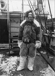
The area is named after Robert E. Peary, who first explored it during his expedition of 1891 to 1892.
(erected in 1948) and Kap Harald Moltke (erected in 1972). Both stations were built on initiative of Eigil Knuth
, and have been the basis for many scientific expeditions. Kap Harald Moltke station was built later in connection with use of the natural runway east of Jørgen Brønlund Fjord mouth. . The stations located 10 km from each other on either side of the fjord, with Brønlundhus on the western side, and communication between them in summer is by boat, depending on ice conditions. Since the death of Eigil Knuth, the stations are administered by Peary Land Foundation. Today, Brønlundhus can be characterised as a museum, with a collection of artefacts from polar explorations.
Peninsula
A peninsula is a piece of land that is bordered by water on three sides but connected to mainland. In many Germanic and Celtic languages and also in Baltic, Slavic and Hungarian, peninsulas are called "half-islands"....
in northern Greenland
Greenland
Greenland is an autonomous country within the Kingdom of Denmark, located between the Arctic and Atlantic Oceans, east of the Canadian Arctic Archipelago. Though physiographically a part of the continent of North America, Greenland has been politically and culturally associated with Europe for...
, extending into the Arctic Ocean
Arctic Ocean
The Arctic Ocean, located in the Northern Hemisphere and mostly in the Arctic north polar region, is the smallest and shallowest of the world's five major oceanic divisions...
. It reaches from Victoria Fjord
Victoria Fjord
Victoria Fjord or Victoria Inlet is a large fjord in northern Greenland. To the north-west the fjord opens into the Arctic Ocean....
in the west to Independence Fjord
Independence Fjord
Independence Fjord is a large fjord in the eastern part of northern Greenland. It is about long and up to wide. Its mouth, opening to Wandel Sea of the Arctic Ocean is located at...
in the south and southeast, and to the Arctic Ocean in the north, with Cape Morris Jesup
Cape Morris Jesup
Cape Morris Jesup is the northernmost point of mainland Greenland at and is 711.8 km from the geographic North Pole...
, the northernmost point of Greenland's mainland, and Cape Bridgman in the northeast.
Geography
Peary Land is bounded by Lincoln SeaLincoln Sea
Lincoln Sea is a body of water in the Arctic Ocean, stretching from Cape Columbia, Canada, in the west to Cape Morris Jesup, Greenland, in the east. The northern limit is defined as the great circle line between those two headlands. It is covered with sea ice throughout the year, the thickest sea...
(west of Cape Morris Jesup) and Wandel Sea
Wandel Sea
The Wandel Sea is a body of water in the Arctic Ocean, stretching from northeast of Greenland to Svalbard. This arctic sea is located at 82° north longitude and 21° west latitude. Seas farther north and northwest of the Wandel Sea are frozen year-round. The Wandel Sea stretches as far west as Cape...
of the Arctic Ocean
Arctic Ocean
The Arctic Ocean, located in the Northern Hemisphere and mostly in the Arctic north polar region, is the smallest and shallowest of the world's five major oceanic divisions...
in the north. Oodaaq
Oodaaq
Oodaaq or Oodap Qeqert is a bank of gravel and silt northeast of Greenland that has been considered by some to be the most northerly point of land on earth....
island, the northernmost point of land of the world, lies off the north coast. Frederick E. Hyde Fjord
Frederick E. Hyde Fjord
Frederick E. Hyde Fjord is a fjord in Peary Land, north-eastern Greenland. To the east the fjord opens into the Arctic Ocean....
, which cuts into Peary Land from the east 150 km deep, divides it into Northern Peary Land and Southern Peary Land. The coastline is deeply indented by smaller fjord
Fjord
Geologically, a fjord is a long, narrow inlet with steep sides or cliffs, created in a valley carved by glacial activity.-Formation:A fjord is formed when a glacier cuts a U-shaped valley by abrasion of the surrounding bedrock. Glacial melting is accompanied by rebound of Earth's crust as the ice...
s. Highest peak of Peary Land is Mara Mountain
Mara Mountain
Mara Mountain, in northern Greenland, is the closest known mountain to the North Pole. Located in the Roosevelt Mountain Range in Peary Land, it is approximately 446.17 miles away from the North Pole...
of Roosevelt Mountain Range, 1,155 meters high.
Peary Land is not part of any municipality, but is part of the Northeast Greenland National Park
Northeast Greenland National Park
Northeast Greenland National Park is the largest national park in the world, with an area of , making the park larger than 163 countries. It is the only national park in Greenland, and the most northerly national park in the world, its most northerly point reaching slightly further than the most...
. The size of the region is about 375 km east-west and 200 km north-south, with an estimated area of 57 000 km². It is only a bit more than 700 km south of the North Pole
North Pole
The North Pole, also known as the Geographic North Pole or Terrestrial North Pole, is, subject to the caveats explained below, defined as the point in the northern hemisphere where the Earth's axis of rotation meets its surface...
. The area is mountainous, with elevations to 1 950 m in the heavily glaciated Roosevelt Range and to comparable heights in the little-explored H.H. Benedict Range. It is free of Greenland's inland ice cap
Ice cap
An ice cap is an ice mass that covers less than 50 000 km² of land area . Masses of ice covering more than 50 000 km² are termed an ice sheet....
. Being mostly north of the 82°N parallel
82nd parallel north
The 82nd parallel north is a circle of latitude that is 82 degrees north of the Earth's equatorial plane, in the Arctic. It passes through the Arctic Ocean and North America....
, it contains the most northerly ice-free region of the world, mostly in Southern Peary Land (such as Melville Land just north of the Independence Fjord. Precipitation levels are so low (only about 25 to 200 mm per year, all as snow) that it is called a polar desert. It was not covered by glaciers during the most recent ice age. However, in its western part, there is a local icecap, Hans Tausen Icecap, with ice at least 344 m thick.
Originally, Peary Land was believed to be an island, separated from the main island by Peary Channel, an assumed connection between Victoria Fjord and Independence Fjord).
Fauna and flora
Caribou and musk oxMusk Ox
The muskox is an Arctic mammal of the family Bovidae, noted for its thick coat and for the strong odor emitted by males, from which its name derives. This musky odor is used to attract females during mating season...
en are supported by the sparse vegetation, which covers only about 5% of the surface, and which includes 33 species of flowering plants. Other fauna includes arctic fox
Arctic fox
The arctic fox , also known as the white fox, polar fox or snow fox, is a small fox native to Arctic regions of the Northern Hemisphere and is common throughout the Arctic tundra biome. The Greek word alopex, means a fox and Vulpes is the Latin version...
, polar wolf
Arctic Wolf
The Arctic Wolf , also called Polar Wolf or White Wolf, is a subspecies of the Gray Wolf, a mammal of the family Canidae. Arctic Wolves inhabit the Canadian Arctic, Alaska and the northern parts of Greenland....
, polar bear
Polar Bear
The polar bear is a bear native largely within the Arctic Circle encompassing the Arctic Ocean, its surrounding seas and surrounding land masses. It is the world's largest land carnivore and also the largest bear, together with the omnivorous Kodiak Bear, which is approximately the same size...
, and arctic hare
Arctic Hare
The arctic hare , or polar rabbit is a species of hare which is adapted largely to polar and mountainous habitats. The arctic hare survives with a thick coat of fur and usually digs holes under the ground or snow to keep warm and sleep...
.
One to two million years ago, when climates were warmer, trees such as larch
Larch
Larches are conifers in the genus Larix, in the family Pinaceae. Growing from 15 to 50m tall, they are native to much of the cooler temperate northern hemisphere, on lowlands in the north and high on mountains further south...
, black spruce
Black Spruce
Picea mariana is a species of spruce native to northern North America, from Newfoundland west to Alaska, and south to northern New York, Minnesota and central British Columbia...
, birch
Birch
Birch is a tree or shrub of the genus Betula , in the family Betulaceae, closely related to the beech/oak family, Fagaceae. The Betula genus contains 30–60 known taxa...
, yew
Taxus
Taxus is a genus of yews, small coniferous trees or shrubs in the yew family Taxaceae. They are relatively slow-growing and can be very long-lived, and reach heights of 1-40 m, with trunk diameters of up to 4 m...
, and thuja
Thuja
Thuja is a genus of coniferous trees in the Cupressaceae . There are five species in the genus, two native to North America and three native to eastern Asia...
grew in the northernmost Peary Land.
Human exploration and settlement
Inuit
The Inuit are a group of culturally similar indigenous peoples inhabiting the Arctic regions of Canada , Denmark , Russia and the United States . Inuit means “the people” in the Inuktitut language...
cultures, during which times the climate was milder than presently:
- Independence I cultureIndependence I cultureThe Independence I culture was a Paleo-Eskimo culture of peoples who lived in northern Greenland from 2,400 to 1,000 B.C. It is named after Independence Fjord. During this time they coexisted with the Saqqaq culture of southern Greenland...
(around 2000 B.C., oldest remains dating from 2400 B.C.) - Independence II cultureIndependence II cultureThe Independence II culture was a Paleo-Eskimo culture that flourished in northern and northeastern Greenland , north and south of the Independence Fjord. The Independence II culture arose in the same region as the Independence I culture, which became extinct six centuries earlier...
(800 B.C. to 200 B.C.) - Thule culture (around 1300 AD)
The area is named after Robert E. Peary, who first explored it during his expedition of 1891 to 1892.
Research
There are two Arctic research stations on Jørgen Brønlund Fjord, BrønlundhusBrønlundhus
Brønlundhus, on some maps also Brønlundfjord or Brönlundfjord, is a former research station and radio station located on the western shore of Jørgen Brønlund Fjord in southern Peary Land, in northern Greenland. It is named after Greenlandic Arctic researcher Jørgen Brønlund, or after the namesake...
(erected in 1948) and Kap Harald Moltke (erected in 1972). Both stations were built on initiative of Eigil Knuth
Eigil Knuth
Count Eigil Knuth was a Danish explorer, archaeologist, sculptor and writer. He is referred to as the Nestor of Danish polar explorers. His archaeological investigations were made in Peary Land and adjacent areas of High Arctic Greenland...
, and have been the basis for many scientific expeditions. Kap Harald Moltke station was built later in connection with use of the natural runway east of Jørgen Brønlund Fjord mouth. . The stations located 10 km from each other on either side of the fjord, with Brønlundhus on the western side, and communication between them in summer is by boat, depending on ice conditions. Since the death of Eigil Knuth, the stations are administered by Peary Land Foundation. Today, Brønlundhus can be characterised as a museum, with a collection of artefacts from polar explorations.