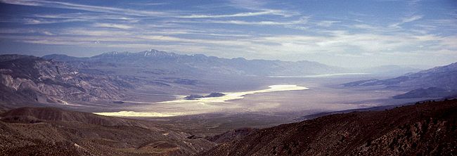
Panamint Valley
Encyclopedia

Argus Range
The Argus Range is a mountain range located in Inyo County, California, southeast of the town of Darwin, between the Coso Range and the Panamint Valley, with the Panamint Range to the east .-Geography:The range contains Maturango Peak, at above sea level...
and Slate Range, and west of the Panamint Range
Panamint Range
The Panamint Range is a short rugged fault-block mountain range on the northern edge of the Mojave Desert, in Death Valley National Park, Inyo County, California, United States.-Geography:...
in the northeastern reach of the Mojave Desert
Mojave Desert
The Mojave Desert occupies a significant portion of southeastern California and smaller parts of central California, southern Nevada, southwestern Utah and northwestern Arizona, in the United States...
, in eastern California
California
California is a state located on the West Coast of the United States. It is by far the most populous U.S. state, and the third-largest by land area...
, United States
United States
The United States of America is a federal constitutional republic comprising fifty states and a federal district...
.
Geography
The northern end of the valley is in Death Valley National ParkDeath Valley National Park
Death Valley National Park is a national park in the U.S. states of California and Nevada located east of the Sierra Nevada in the arid Great Basin of the United States. The park protects the northwest corner of the Mojave Desert and contains a diverse desert environment of salt-flats, sand dunes,...
and Inyo County, California
Inyo County, California
-National protected areas:* Death Valley National Park * Inyo National Forest * Manzanar National Historic Site-Major highways:* U.S. Route 6* U.S. Route 395* State Route 127* State Route 136* State Route 168* State Route 178...
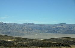
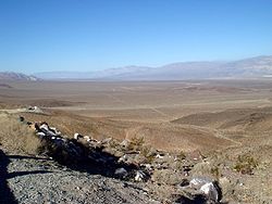
. The valley lies in a north-south direction, and stretches from the Panamint Dunes in the north to the Naval Air Weapons Station China Lake
Naval Air Weapons Station China Lake
- About : is part of under Commander, Navy Installation Command and is located in the Western Mojave Desert region of California, approximately north of Los Angeles. Occupying three counties – Kern, San Bernardino and Inyo – the installation’s closest neighbors are the cities of Ridgecrest,...
in San Bernardino County in the south. The valley is approximately 65 miles (105 km) in length, and is more than 10 miles (16 km) wide in the Hall Canyon area.
Features
- The ghost town of BallaratBallarat, CaliforniaBallarat is an unincorporated community in Inyo County, California. It lies at an elevation of 1079 feet .Today, Ballarat is a virtual ghost town. It was founded in 1896 as a supply point for the mines in the canyons of the Panamint Range. A quarter-mile to the south is Post Office Springs, a...
is located in the Panamint Valley about three miles east of Trona Road, near Happy Canyon. - A radar station is located near the town of Ballarat at the south end of the valley.
- Multiple sites along SR 190, which crosses the north part of the valley, provide excellent vantage points to view low altitude military aircraft operations.
- Barker RanchBarker RanchBarker Ranch is infamous as the last hideout of Charles Manson and his "family" after the gruesome Los Angeles murder spree. It is located inside Death Valley National Park in eastern California....
, the last hideout of Charles MansonCharles MansonCharles Milles Manson is an American criminal who led what became known as the Manson Family, a quasi-commune that arose in California in the late 1960s. He was found guilty of conspiracy to commit the Tate/LaBianca murders carried out by members of the group at his instruction...
and the site at which he was arrested in 1969, is located at the southern end of the valley off Goler Canyon Road. Most of the Barker "Family" Ranch was burned down in 2009. - The valley is an internally drained endorheic basin and its central salt flat/hardpan can contain an ephemeralEphemeralEphemeral things are transitory, existing only briefly. Typically the term is used to describe objects found in nature, although it can describe a wide range of things....
lake, like it did after unusually heavy rains in the spring of 2005. During pluvialPluvial lakeA pluvial lake is a landlocked basin which fills with rainwater during times of glaciation, when precipitation is higher. Pluvial lakes that have since evaporated and dried out may also be referred to as paleolakes.-Geology:...
periods of the PleistocenePleistoceneThe Pleistocene is the epoch from 2,588,000 to 11,700 years BP that spans the world's recent period of repeated glaciations. The name pleistocene is derived from the Greek and ....
, inflow from a chain of streams and lakes to the northwest sustained a large lake that overflowed into Lake ManlyLake ManlyLake Manly is a pluvial, former freshwater, endorheic, rift lake that filled the Death Valley basin of Inyo County, California through the Holocene before the area's climate changed to desert. Following its isolation from the Colorado River system, Lake Manly receded by evaporation with Badwater...
in Death ValleyDeath ValleyDeath Valley is a desert valley located in Eastern California. Situated within the Mojave Desert, it features the lowest, driest, and hottest locations in North America. Badwater, a basin located in Death Valley, is the specific location of the lowest elevation in North America at 282 feet below...
.
Military use
R-2508 Special Use Airspace Complex
The R-2508 Complex includes all the airspace and associated land presently used and managed by the three principal military activities in the Upper Mojave Desert region:*Air Force Flight Test Center , Edwards Air Force Base...
http://r2508.edwards.af.mil/index.html. The Panamint Military Operating Area (MOA) covers the entire valley north to Hunter Mountain from 200 ft AGL up to FL180 with an Air Traffic Control Assigned Airspace (ATCAA) located above the same area from FL180 up to FL600. The airspace is primarily used by military aircraft from Nellis AFB
Nellis Air Force Base
Nellis Air Force Base is a United States Air Force Base, located approximately northeast of Las Vegas, Nevada. It is under the jurisdiction of Air Combat Command .-Overview:...
, Edwards AFB
Edwards Air Force Base
Edwards Air Force Base is a United States Air Force base located on the border of Kern County, Los Angeles County, and San Bernardino County, California, in the Antelope Valley. It is southwest of the central business district of North Edwards, California and due east of Rosamond.It is named in...
, NAWS China Lake
Naval Air Weapons Station China Lake
- About : is part of under Commander, Navy Installation Command and is located in the Western Mojave Desert region of California, approximately north of Los Angeles. Occupying three counties – Kern, San Bernardino and Inyo – the installation’s closest neighbors are the cities of Ridgecrest,...
, and NAS Lemoore
Naval Air Station Lemoore
Naval Air Station Lemoore or NAS Lemoore is a United States Navy base, located in Kings County and Fresno County, California. Lemoore Station, California, a census-designated place, is located inside the base's borders....
for high and low altitude mission training. Military aircraft utilize radio communications on 291.6 MHz or 120.25 MHz while operating in the Panamint MOA; however, military aircraft throughout the R-2508 complex often use 315.9 MHz when conducting low altitude operations below 1500 ft AGL.