
Panamint Range
Encyclopedia
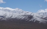
The Panamint Range is a short rugged fault-block mountain
range on the northern edge of the Mojave Desert
, in Death Valley National Park
, Inyo County, California
, United States
.
 The range runs north-south for approximately 100 miles (160.9 km) through Inyo County
, forming the western wall of Death Valley
and separating it from the Panamint Valley
to the west. The range is part of the Basin and Range Province, at the western end of the Great Basin
.
The highest peak in the range is Telescope Peak
with an elevation of 11049 feet (3,367.7 m).
and Badwater Basin in Death Valley
are visible from some points on the Panamint Range, making it the only location
where one can simultaneously see both the highest and lowest points in the contiguous United States
.
The historic mining community of Ballarat
, now a ghost town
, is on the western side of the Panamint Range. The Wildrose Charcoal Kilns ruins are near Wildrose Canyon in the northern area.
Fault-block mountain
Fault-block landforms are formed when large areas of bedrock are widely broken up by faults creating large vertical displacements of continental crust....
range on the northern edge of the Mojave Desert
Mojave Desert
The Mojave Desert occupies a significant portion of southeastern California and smaller parts of central California, southern Nevada, southwestern Utah and northwestern Arizona, in the United States...
, in Death Valley National Park
Death Valley National Park
Death Valley National Park is a national park in the U.S. states of California and Nevada located east of the Sierra Nevada in the arid Great Basin of the United States. The park protects the northwest corner of the Mojave Desert and contains a diverse desert environment of salt-flats, sand dunes,...
, Inyo County, California
Inyo County, California
-National protected areas:* Death Valley National Park * Inyo National Forest * Manzanar National Historic Site-Major highways:* U.S. Route 6* U.S. Route 395* State Route 127* State Route 136* State Route 168* State Route 178...
, United States
United States
The United States of America is a federal constitutional republic comprising fifty states and a federal district...
.
Geography
Inyo County, California
-National protected areas:* Death Valley National Park * Inyo National Forest * Manzanar National Historic Site-Major highways:* U.S. Route 6* U.S. Route 395* State Route 127* State Route 136* State Route 168* State Route 178...
, forming the western wall of Death Valley
Death Valley
Death Valley is a desert valley located in Eastern California. Situated within the Mojave Desert, it features the lowest, driest, and hottest locations in North America. Badwater, a basin located in Death Valley, is the specific location of the lowest elevation in North America at 282 feet below...
and separating it from the Panamint Valley
Panamint Valley
The Panamint Valley is a long basin located east of the Argus Range and Slate Range, and west of the Panamint Range in the northeastern reach of the Mojave Desert, in eastern California, United States.-Geography:...
to the west. The range is part of the Basin and Range Province, at the western end of the Great Basin
Great Basin
The Great Basin is the largest area of contiguous endorheic watersheds in North America and is noted for its arid conditions and Basin and Range topography that varies from the North American low point at Badwater Basin to the highest point of the contiguous United States, less than away at the...
.
The highest peak in the range is Telescope Peak
Telescope Peak
Telescope Peak is the highest point within Death Valley National Park, in the US state of California. It is also the highest point of the Panamint Range, and lies in Inyo County. From atop this desert mountain one can see for over one hundred miles in many directions, including west to Mount...
with an elevation of 11049 feet (3,367.7 m).
Features
Both Mount WhitneyMount Whitney
Mount Whitney is the highest summit in the contiguous United States with an elevation of . It is on the boundary between California's Inyo and Tulare counties, west-northwest of the lowest point in North America at Badwater in Death Valley National Park...
and Badwater Basin in Death Valley
Death Valley
Death Valley is a desert valley located in Eastern California. Situated within the Mojave Desert, it features the lowest, driest, and hottest locations in North America. Badwater, a basin located in Death Valley, is the specific location of the lowest elevation in North America at 282 feet below...
are visible from some points on the Panamint Range, making it the only location
Dante's View
Dante's View is a viewpoint terrace at 5,475 feet height, on the north side of Coffin Peak, along the crest of the Black Mountains, overlooking Death Valley...
where one can simultaneously see both the highest and lowest points in the contiguous United States
Contiguous United States
The contiguous United States are the 48 U.S. states on the continent of North America that are south of Canada and north of Mexico, plus the District of Columbia....
.
The historic mining community of Ballarat
Ballarat, California
Ballarat is an unincorporated community in Inyo County, California. It lies at an elevation of 1079 feet .Today, Ballarat is a virtual ghost town. It was founded in 1896 as a supply point for the mines in the canyons of the Panamint Range. A quarter-mile to the south is Post Office Springs, a...
, now a ghost town
Ghost town
A ghost town is an abandoned town or city. A town often becomes a ghost town because the economic activity that supported it has failed, or due to natural or human-caused disasters such as floods, government actions, uncontrolled lawlessness, war, or nuclear disasters...
, is on the western side of the Panamint Range. The Wildrose Charcoal Kilns ruins are near Wildrose Canyon in the northern area.
See also
- Telescope PeakTelescope PeakTelescope Peak is the highest point within Death Valley National Park, in the US state of California. It is also the highest point of the Panamint Range, and lies in Inyo County. From atop this desert mountain one can see for over one hundred miles in many directions, including west to Mount...
- Panamint ValleyPanamint ValleyThe Panamint Valley is a long basin located east of the Argus Range and Slate Range, and west of the Panamint Range in the northeastern reach of the Mojave Desert, in eastern California, United States.-Geography:...
- Category: Death Valley
- Category: Geography of Inyo County, California
- Category: Mountain ranges of the Mojave Desert
- Category: Protected areas of the Mojave Desert