
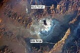
Argus Range
Encyclopedia
The Argus Range is a mountain range located in Inyo County, California
, southeast of the town of Darwin
, between the Coso Range
and the Panamint Valley
, with the Panamint Range
to the east .
, at 8839 feet (2,694.1 m) above sea level. The northern part of the mountains begin just south of the Panamint Springs Resort
on Highway 190
and continues south to Searles Lake
, near the town of Trona, California
.
The crest of the Argus Range is located within a military reservation and so the peaks of this range are off-limits to the general public. The two peaks that are most alluring to would-be hikers are Argus Peak (6562') located just north of Trona
above the Searles Valley
and Maturango Peak
(8,839') towering to the west of Panamint Valley
.
----
Inyo County, California
-National protected areas:* Death Valley National Park * Inyo National Forest * Manzanar National Historic Site-Major highways:* U.S. Route 6* U.S. Route 395* State Route 127* State Route 136* State Route 168* State Route 178...
, southeast of the town of Darwin
Darwin, California
Darwin is a census-designated place in Inyo County, California, United States. Darwin is located southeast of Keeler, at an elevation of 4790 feet . The population was 43 at the 2010 census, down from 54 at the 2000 census. It is named after Dr...
, between the Coso Range
Coso Range
The Coso Range of eastern California is located immediately south of Owens Lake , east of the Sierra Nevada Mountains, and west of the Argus Range. The southern part of the range lies in the restricted Naval Air Weapons Station China Lake...
and the Panamint Valley
Panamint Valley
The Panamint Valley is a long basin located east of the Argus Range and Slate Range, and west of the Panamint Range in the northeastern reach of the Mojave Desert, in eastern California, United States.-Geography:...
, with the Panamint Range
Panamint Range
The Panamint Range is a short rugged fault-block mountain range on the northern edge of the Mojave Desert, in Death Valley National Park, Inyo County, California, United States.-Geography:...
to the east .
Geography
The range contains Maturango PeakMaturango Peak
Maturango Peak is the highest mountain in the Argus Range. It is located in Inyo County, California and rises 8,839 feet above sea level.-Origin of the name:The name “Maturango” first appeared in 1877 on the Wheeler Survey Map...
, at 8839 feet (2,694.1 m) above sea level. The northern part of the mountains begin just south of the Panamint Springs Resort
Panamint Springs, California
Panamint Springs is an unincorporated community in Inyo County, California. It lies at an elevation of 1926 feet .Panamint Springs is located along State Route 190 between Old Toll Road and SR178/Panamint Valley Road...
on Highway 190
California State Route 190
State Route 190 is a state highway in the U.S. state of California that is split into two parts by the Sierra Nevada. The western portion of begins at Tipton at a junction with State Route 99 and heads east towards Porterville before ending at Quaking Aspen in the Sequoia National Forest...
and continues south to Searles Lake
Searles Lake
Searles Lake is an endorheic dry lake in the Mojave Desert of San Bernardino County, California, with the mining community, Trona on its western shore. The evaporite basin is approximately long and at its widest point, yielding 1.7 million tons annually of industrial minerals within the basin to...
, near the town of Trona, California
Trona, Inyo County, California
Trona is a census-designated place in Inyo County, California. Trona sits at an elevation of . The 2010 United States census reported Trona's population was 18.-Demographics:...
.
The crest of the Argus Range is located within a military reservation and so the peaks of this range are off-limits to the general public. The two peaks that are most alluring to would-be hikers are Argus Peak (6562') located just north of Trona
Trona, Inyo County, California
Trona is a census-designated place in Inyo County, California. Trona sits at an elevation of . The 2010 United States census reported Trona's population was 18.-Demographics:...
above the Searles Valley
Searles Valley
Searles Valley is a valley in the northern Mojave Desert of California, with the northern half in Inyo County and the southern half in San Bernardino County, California, United States....
and Maturango Peak
Maturango Peak
Maturango Peak is the highest mountain in the Argus Range. It is located in Inyo County, California and rises 8,839 feet above sea level.-Origin of the name:The name “Maturango” first appeared in 1877 on the Wheeler Survey Map...
(8,839') towering to the west of Panamint Valley
Panamint Valley
The Panamint Valley is a long basin located east of the Argus Range and Slate Range, and west of the Panamint Range in the northeastern reach of the Mojave Desert, in eastern California, United States.-Geography:...
.
Argus Range Wilderness Area
The Argus Range Wilderness Area, under the administration of the Bureau of Land Management (BLM), runs 28 miles (45.1 km) along the east side of the Argus Range. It extends from the military reservation on the west to the foot of the Argus Range on the east. For most of its length, this wilderness area is no more than two miles (3 km) wide. Several private property holdings are located within this wilderness area including a rather deep cherry-stem at Snow Canyon and a 40 acres (161,874.4 m²) parcel known as Onyx Springs between Shepherd and Bendire Canyons. Many land-owners were affected by the creation of the Argus Range Wilderness Area in 1994.External links
- Official Argus Range Wilderness Area website
- BLM Argus Range Wilderness Area Map
- Argus Range Information and Pictures at blackturtle.us
----