

Palouse Falls
Encyclopedia
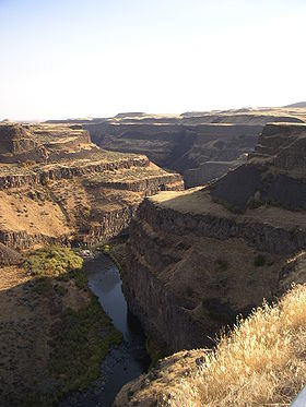
The Palouse Falls lies on the Palouse River
, about 4 mi (6.4 km) upstream of the confluence with the Snake River
in southeast Washington, United States
. The falls are 200 ft (61 m) in height. The falls consists of an upper falls with a drop of ~20 feet (6.1 m) which lies 1000 feet (304.8 m) north northwest of the main drop, and a lower falls, with a drop of ~180 feet (54.9 m).
. These falls and the canyon downstream comprise an important feature of the channeled scablands
created by the great Missoula Floods
that swept periodically across eastern Washington and across the Columbia River Plateau
during the Pleistocene epoch
.
The ancestral Palouse river flowed through the currently dry Washtucna Coulee to the Columbia River
. The Palouse Falls and surrounding canyons were created when the Missoula Floods overtopped the south valley wall of the ancestral Palouse River, diverting it to the current course to the Snake River
by erosion of a new channel.
The area is characterized by interconnected and hanging flood-created coulees, cataracts, plunge pools, kolk
created potholes, rock benches, buttes and pinnacles typical of scablands. Palouse Falls State Park is located at the falls, protecting this part of the uniquely scenic area.
generation. This would have provided over one third of the county's power and would have reduced ratepayer charges substantially. However the majority of the ratepayers declined to approve the investment, preserving this geologically significant feature.
 The falls are included in Washington State's Palouse Falls State Park
, which provides access to the falls and has displays explaining the region's unique geology, as well as its historical ties (the Palouse Indians
and the Mullan Road
both took advantage of the easy access to the plateau in the vicinity of the falls).
ran the falls in a kayak setting an unofficial world record for the highest waterfall run. Bradt's media agent
released the video footage of him dropping over the falls to Sports Illustrated
, who carried it on their website. The magazine carried a two-page photo of the feat in its May 18 issue. The photos were also reproduced in Spain's Hola magazine's international issue of September 23, 2009.
geology professor led a team of students who determined:
Palouse River
The Palouse River is a tributary of the Snake River located in the U.S. states of Washington and Idaho. It flows for southwestwards, primarily through the Palouse region of southeastern Washington...
, about 4 mi (6.4 km) upstream of the confluence with the Snake River
Snake River
The Snake is a major river of the greater Pacific Northwest in the United States. At long, it is the largest tributary of the Columbia River, the largest North American river that empties into the Pacific Ocean...
in southeast Washington, United States
United States
The United States of America is a federal constitutional republic comprising fifty states and a federal district...
. The falls are 200 ft (61 m) in height. The falls consists of an upper falls with a drop of ~20 feet (6.1 m) which lies 1000 feet (304.8 m) north northwest of the main drop, and a lower falls, with a drop of ~180 feet (54.9 m).
Geology
The canyon at the falls is 115 meters (377 ft) deep, exposing a large cross-section of the Columbia River Basalt GroupColumbia River Basalt Group
The Columbia River Basalt Group is a large igneous province that lies across parts of the Western United States. It is found in the U.S. states of Washington, Oregon, Idaho, Nevada, and California...
. These falls and the canyon downstream comprise an important feature of the channeled scablands
Channeled scablands
The Channeled Scablands are a unique geological erosion feature in the U.S. state of Washington. They were created by the cataclysmic Missoula Floods that swept periodically across eastern Washington and down the Columbia River Plateau during the Pleistocene epoch. Geologist J Harlen Bretz coined...
created by the great Missoula Floods
Missoula Floods
The Missoula Floods refer to the cataclysmic floods that swept periodically across eastern Washington and down the Columbia River Gorge at the end of the last ice age. The glacial flood events have been researched since the 1920s...
that swept periodically across eastern Washington and across the Columbia River Plateau
Columbia River Plateau
The Columbia Plateau is a geologic and geographic region that lies across parts of the U.S. states of Washington, Oregon, and Idaho. It is a wide flood basalt plateau between the Cascade Range and the Rocky Mountains, cut through by the Columbia River...
during the Pleistocene epoch
Pleistocene
The Pleistocene is the epoch from 2,588,000 to 11,700 years BP that spans the world's recent period of repeated glaciations. The name pleistocene is derived from the Greek and ....
.
The ancestral Palouse river flowed through the currently dry Washtucna Coulee to the Columbia River
Columbia River
The Columbia River is the largest river in the Pacific Northwest region of North America. The river rises in the Rocky Mountains of British Columbia, Canada, flows northwest and then south into the U.S. state of Washington, then turns west to form most of the border between Washington and the state...
. The Palouse Falls and surrounding canyons were created when the Missoula Floods overtopped the south valley wall of the ancestral Palouse River, diverting it to the current course to the Snake River
Snake River
The Snake is a major river of the greater Pacific Northwest in the United States. At long, it is the largest tributary of the Columbia River, the largest North American river that empties into the Pacific Ocean...
by erosion of a new channel.
The area is characterized by interconnected and hanging flood-created coulees, cataracts, plunge pools, kolk
Kolk
A kolk is an underwater vortex that is created when rapidly rushing water passes an underwater obstacle in boundary areas of high shear. High velocity gradients produce a violently rotating column of water, similar to a tornado. Kolks are capable of plucking multi-ton blocks of rock and...
created potholes, rock benches, buttes and pinnacles typical of scablands. Palouse Falls State Park is located at the falls, protecting this part of the uniquely scenic area.
Economic proposals
In 1984 the Franklin County Public Utilitity District proposed a 30 m (98.4 ft) high dam be constructed upstream of the falls, allowing for a significant hydraulic head for hydroelectric powerHydroelectricity
Hydroelectricity is the term referring to electricity generated by hydropower; the production of electrical power through the use of the gravitational force of falling or flowing water. It is the most widely used form of renewable energy...
generation. This would have provided over one third of the county's power and would have reduced ratepayer charges substantially. However the majority of the ratepayers declined to approve the investment, preserving this geologically significant feature.
Palouse Falls State Park
Palouse Falls State Park
Palouse Falls State Park is a member of the Washington state park system in the Palouse region of Eastern Washington, USA. It is named for the Palouse Falls on the Palouse River, which are part of the park....
, which provides access to the falls and has displays explaining the region's unique geology, as well as its historical ties (the Palouse Indians
Palus (tribe)
The Palus are a Sahaptin tribe recognized in the Treaty of 1855 with the Yakamas . A variant spelling is Palouse, which was the source of the name for the fertile prairie of Washington and Idaho.- Ethnography :...
and the Mullan Road
Mullan Road
Mullan Road was the first wagon road to cross the Rocky Mountains to the Inland of the Pacific Northwest. It was built by US Army Lieut. John Mullan between the spring of 1859 and summer 1860. It led from Fort Benton, Montana, the navigational head of the Missouri River to Fort Walla Walla,...
both took advantage of the easy access to the plateau in the vicinity of the falls).
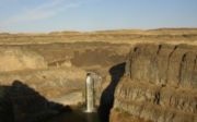
Kayaking
On April 21, 2009, Tyler BradtTyler Bradt
Tyler Bradt is an American professional whitewater kayaker who holds the unofficial world record for the highest waterfall successfully run in a kayak.-World record:...
ran the falls in a kayak setting an unofficial world record for the highest waterfall run. Bradt's media agent
Press agent
A press agent, or flack, is a professional publicist who acts on behalf of his or her client on all matters involving public relations. Press agents are typically employed by public personalities and organizations such as performers and businesses...
released the video footage of him dropping over the falls to Sports Illustrated
Sports Illustrated
Sports Illustrated is an American sports media company owned by media conglomerate Time Warner. Its self titled magazine has over 3.5 million subscribers and is read by 23 million adults each week, including over 18 million men. It was the first magazine with circulation over one million to win the...
, who carried it on their website. The magazine carried a two-page photo of the feat in its May 18 issue. The photos were also reproduced in Spain's Hola magazine's international issue of September 23, 2009.
Height of the falls
As a result of the unofficial world record for the highest waterfall run, questions were raised about the correct height of the main drop for the falls. In the interest of claiming a world record, Bradt's team measured the falls and determined the height was 186 feet (56.7 m) from the top pool immediately above main drop to the plunge pool immediately below. A regional paper, The Spokesman-Review inquired with Washington state officials and determined that the previous height measurement was performed in 1945 using earlier techniques; the state was not prepared to perform an updated measurement using laser surveying equipment. However a Whitman CollegeWhitman College
Whitman College is a private, co-educational, non-sectarian, residential undergraduate liberal arts college located in Walla Walla, Washington. Initially founded as a seminary by a territorial legislative charter in 1859, the school became a four year degree granting institution in 1883...
geology professor led a team of students who determined:
- The height of the plunge pool and the top pool both vary with river flows, but not uniformly.
- The flow peak for 2009 was 8300 cuft/s on Jan. 9 - at that time the river top pool elevation was 12 feet (3.7 m) higher than when the measurements were made on August 18.
- The estimated plunge pool elevation difference between January and August was 7 feet (2.1 m).
- Hence there is a 5 feet (1.5 m) variability in the height of falls over this period.
- The likely height of the falls at the main drop during the highest waterfall record attempt was between 175 and 180 feet (54.9 m).
External links
- Photo of the falls, Pacific Northwest National LaboratoryPacific Northwest National LaboratoryPacific Northwest National Laboratory is one of the United States Department of Energy National Laboratories, managed by the Department of Energy's Office of Science. The main campus of the laboratory is in Richland, Washington....