

Oyapock River
Encyclopedia
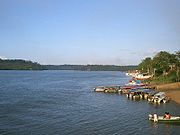
The Oyapock or Oiapoque River is a 370-km (230-mi) long river in South America
South America
South America is a continent situated in the Western Hemisphere, mostly in the Southern Hemisphere, with a relatively small portion in the Northern Hemisphere. The continent is also considered a subcontinent of the Americas. It is bordered on the west by the Pacific Ocean and on the north and east...
that forms most of the border between French Guiana
French Guiana
French Guiana is an overseas region of France, consisting of a single overseas department located on the northern Atlantic coast of South America. It has borders with two nations, Brazil to the east and south, and Suriname to the west...
and the Brazil
Brazil
Brazil , officially the Federative Republic of Brazil , is the largest country in South America. It is the world's fifth largest country, both by geographical area and by population with over 192 million people...
ian state of Amapá
Amapá
Amapá is one of the states of Brazil, located in the extreme north, bordering French Guiana and Suriname to the north. To the east is the Atlantic Ocean, and to the south and west is the Brazilian state of Pará. Perhaps one of the main features of the state is the River Oiapoque, as it was once...
. It rises in the Tumuk Humak
Tumuk Humak Mountains
The Tumuk Humak Mountains are a mountain range in South America, stretching about east-west in the border area between Brazil in the south, Suriname and French Guiana in the north. In the language of the Apalam and Wayana peoples, Tumucumaque means "the mountain rock symbolizing the struggle...
mountain range and flows into the Atlantic Ocean
Atlantic Ocean
The Atlantic Ocean is the second-largest of the world's oceanic divisions. With a total area of about , it covers approximately 20% of the Earth's surface and about 26% of its water surface area...
, where its estuary
Estuary
An estuary is a partly enclosed coastal body of water with one or more rivers or streams flowing into it, and with a free connection to the open sea....
forms a large bay
Bay
A bay is an area of water mostly surrounded by land. Bays generally have calmer waters than the surrounding sea, due to the surrounding land blocking some waves and often reducing winds. Bays also exist as an inlet in a lake or pond. A large bay may be called a gulf, a sea, a sound, or a bight...
bordering on Cape Orange
Cape Orange
Cape Orange is a cape on the coast of Brazil, separated from the coast of French Guiana by a large bay watered by the estuary of the Oyapock River . Cape Orange is the northernmost point of the Brazilian state of Amapá...
.
Vicente Yáñez Pinzón
Vicente Yáñez Pinzón
Vicente Yáñez Pinzón was a Spanish navigator, explorer, and conquistador, the youngest of the Pinzón brothers...
was said to be the first European person to see the Oiapoque River in the first years of the 16th century. It has been called Japoc, Yapoc, Iapoco, and even Vicente Pinzón River. Early European colonists referred to the river as the Wiapoco, and it was the site of early settlements by Briton Robert Harcourt in 1608 and Dutchman Jan van Ryen
Jan van Ryen
Jan van Ryen was a 17th century Dutch privateer, explorer, and colonist. He was granted a commission by the Dutch West Indies Company and active against the Spanish in the West Indies during the 1620s. He and Claude Prevost attempted to establish Dutch colonies in Guyana, although they both failed...
in 1627. The name Oiapoque has been officially used from 1900, when a territorial dispute between Brazil and France
France
The French Republic , The French Republic , The French Republic , (commonly known as France , is a unitary semi-presidential republic in Western Europe with several overseas territories and islands located on other continents and in the Indian, Pacific, and Atlantic oceans. Metropolitan France...
was resolved through Swiss
Switzerland
Switzerland name of one of the Swiss cantons. ; ; ; or ), in its full name the Swiss Confederation , is a federal republic consisting of 26 cantons, with Bern as the seat of the federal authorities. The country is situated in Western Europe,Or Central Europe depending on the definition....
diplomatic arbitration.
False northernmost point of Brazil
In Brazil, both the mouth of the Oyapock and nearby Cape Orange are often mistaken for the country's northernmost point. Until the mid- to late 20th century, this information could even be found in many Brazilian schoolbooks. Brazil's true northernmost point is far inland, on Monte CaburaíMonte Caburaí
Monte Caburaí is a mountain located on the border between the South American countries of Brazil and Guyana standing at above sea level. The source of the Uailã or Ailã river, located on the mountain, is the northernmost point of Brazil....
, in the state of Roraima
Roraima
Roraima is the northernmost and least populated state of Brazil, located in the Amazon region. It borders the states of Amazonas and Pará, as well as the nations of Venezuela and Guyana. The population is 400,000 and the capital is Boa Vista...
, hundreds of kilometres from the Oyapock and almost a full degree more to the north. The mouth of the Oyapock is the northern end of the Brazilian coast, although not the northernmost point of it, which is at neighbouring Cape Orange.
Reflecting that common mistake, there is a popular expression in Brazilian Portuguese
Brazilian Portuguese
Brazilian Portuguese is a group of Portuguese dialects written and spoken by most of the 190 million inhabitants of Brazil and by a few million Brazilian emigrants, mainly in the United States, United Kingdom, Portugal, Canada, Japan and Paraguay....
saying "do Oiapoque ao Chuí" ("from the Oyapock to the Chuí [rivers]"), referring to the country's supposed extreme northern and southern points. It has approximately the same meaning as the American
United States
The United States of America is a federal constitutional republic comprising fifty states and a federal district...
expression "from coast to coast" - i.e., it is used to refer to something that encompasses the whole country.
Bridge
The Oyapock River BridgeOyapock River Bridge
The Oyapock River Bridge is cable-stayed bridge built and expected to be inaugurated in 2011. It will span the Oyapock River to link the cities of Oiapoque in Brazil and Saint-Georges de l'Oyapock in French Guiana....
is being built across the river to connect the towns of Oiapoque
Oiapoque
Oiapoque is a municipality in the north of the state of Amapá, Brazil. Its population is 11,449 and its area is 22,625 km². Oiapoque is also a major river in the same state, forming the international border with French Guiana...
in Brazil and Saint-Georges de l'Oyapock in French Guiana. It is the first international land border connection of French Guiana.