
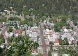
Ouray, Colorado
Encyclopedia
The historic City of Ouray (icon) is a Home Rule Municipality that is the county seat
and the most populous city of Ouray County
, Colorado
, United States
. The city population was 813 at the U.S. Census 2000 and 1,000 as of the U.S. Census 2010. The Ouray Post Office
has the ZIP Code
81427.
 Originally established by miners chasing silver
and gold
in the surrounding mountains, the town at one time boasted more horses and mules than people. Prospectors arrived in the area in 1875. At the height of the mining, Ouray had more than 30 active mines. The town—after changing its name and that of the county it was in several times—was incorporated on October 2, 1876, named after Chief Ouray
of the Ute
s, a Native American
tribe
. By 1877 Ouray had grown to over 1,000 in population and was named county seat
of the newly formed Ouray County
on March 8, 1877.
The Denver & Rio Grande Railway
arrived in Ouray on December 21, 1887. It would stay until the automobile
and truck
s caused a decline in traffic. The last regularly scheduled passenger train was September 14, 1930. The line between Ouray and Ridgway
was abandoned on March 21, 1953.
In 1986, Bill Fries aka C.W. McCall was elected Mayor, ultimately serving for six years.
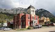
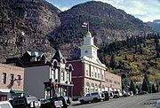
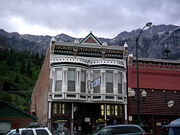
The entirety of Main St. is registered as a National Historic District
with most of the buildings dating back to the late nineteenth century. The Beaumont Hotel
and the Ouray City Hall and Walsh Library are listed on the National Register of Historic Places
individually, while the Ouray County Courthouse
, St. Elmo Hotel
, St. Joseph's Miners' Hospital
(currently housing the Ouray County Historical Society and Museum), Western Hotel
, and Wright's Opera House
are included in the historic district.
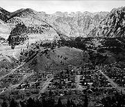 Ouray is located at 38°1′24"N 107°40′20"W (38.023217, −107.672178), in the San Juan Mountains
of southwestern Colorado
. It is about 40 miles (64.4 km) south of Montrose
. It is only 10 miles (16.1 km) northeast of Telluride
, but due to the severity of the landscape, the drive is about 50 miles (80.5 km). Ouray is connected to Silverton
and then Durango
to the south by Red Mountain Pass
which crests at just over 11000 feet (3,352.8 m). The drive along the Uncompahgre River
and over the pass is nicknamed the Million Dollar Highway, although the exact origin of the name is disputed. Yankee Boy Basin
, located a few miles from town, boasts a beautiful spectacle called Twin Falls.
According to the United States Census Bureau
, the city has a total area of 0.8 square miles (2.1 km²), all of it land.
for Ouray is Dfb.
 The entire present-day economy of Ouray is based on tourism
. Ouray bills itself as the "Switzerland
of America" because of its setting at the narrow head of a valley, enclosed on three and a half sides by steep mountains.
Much of the town tourism is focused on ice climbing, mountain biking, hiking and off-roading in four wheel drive(4WD) expeditions into the San Juan Mountains. 4WD vehicles, often called "jeeps" regardless of make, can be rented from a number of outfitters downtown. Ouray has also become a popular destination for motorcyclists, as it marks the beginning of the Million Dollar Highway. This stretch of highway connects Ouray to its neighboring cities of Silverton and Durango. The Million Dollar Highway is frequently regarded as one of the most beautiful roads in Colorado, but is also considered one of the most dangerous due to its sharp turns, steep ledges, and lack of guard rails. Popular destinations include Yankee Boy Basin, Engineer Mountain, and Black Bear Road
. Recording artist (and later Ouray mayor) C.W. McCall helped make Black Bear famous in the area. His song "Black Bear Road" borrowed the phrase, "you don't have to be crazy to drive this road, but it helps," from a sign once posted somewhere at the beginning of Black Bear Pass.
Ouray is the winter ice-climbing capital of the U.S. The world's first ice climbing park, expanding on previously-popular natural falls, consists of dozens of frozen waterfalls from 80 to 200 feet (61 m) high farmed along more than a mile of the Uncompahgre Gorge
. The water is supplied by a sprinkler system developed and maintained by a volunteer organization and supported by donations from local businesses, gear manufacturers and climbers. The Ouray Ice Park is free and attracts climbers from around the world. The annual Ice Festival is a weekend-long extravaganza of contests, exhibitions and instruction with many of the world's top ice climbers. Ice climbing has been a boon to the local economy as well, with hotels and restaurants that previously closed through the winter months now staying open to accommodate climbers.
There are numerous waterfalls along the road from Durango to Ouray, and within the city limits there are 2 waterfalls within easy reach. Cascade Falls is a short, 1/4 mile hike accessible from a parking lot on 8th Avenue. Box Canyon Falls is at the southwest edge of Ouray.
Like most towns in the Colorado mountains, Ouray was originally a mining town. However the evidence does not dominate the town. The largest and most famous mine is the Camp Bird Mine
, the second largest gold mine in Colorado, established by Thomas Walsh in 1896. Even though there was an operation permit filed in 2007, the mine still remains inactive. During its lifespan, the mine produced about 1.5 million troy ounce
s of gold, and 4 million troy ounces of silver, from 1896 to 1990. In 1995 the old milling equipment "The Crusher" was disassembled and sold to a smaller mine located in Mongolia where it operated for about two years. The vacant mine can be seen on the steep 2WD road leading to the 4WD roads to Yankee Boy Basin
and Imogene Pass
.

True Grit was filmed in Ouray County, including some scenes in the city of Ouray and the nearby town of Ridgway and, possibly most notably, the interior of the Ouray County Court House.
In Ayn Rand
's novel Atlas Shrugged
, the protagonist's secret hideaway was in a beautiful valley in the Rocky Mountains called Mulligan's Valley or "Galt's Gulch." Galt's Gulch was inspired by Ouray, where Rand found inspiration to complete the novel, though she greatly expanded the small valley to include her many ideas for the story.
Telluride native David Lavender
related his experiences working at the Camp Bird Mine
in the 1930s in his memoir One Man's West.
Coors
and Chevrolet
have both filmed commercials in the area, particularly Twin Falls in Yankee Boy Basin.
Famous baseball pitcher Smoky Joe Wood was born in Kansas City but grew up in Ouray.
The opening scene to the movie Over the Top with Sylvester Stallone runs straight through downtown.
 As of the census
of 2010, there were 1,000 people, 457 households, and 283 families residing in the city. The population density
was 1,250 people per square mile (454.5/km²). There were 800 housing units at an average density of 1,000 per square mile (363.6/km²). The racial makeup of the city was 95.2% White, 0.1% (1) African American, 0.4% (4) Native American, 0.8% (8) Asian, 1.9% (19) from other races
, and 1.6% (16) from two or more races. Hispanic or Latino of any race were 8.2% of the population.
There were 457 households out of which 26.5% had children under the age of 18 living with them, 48.1% were married couples
living together, 7.7% had a female householder with no husband present, 6.1% had a male householder with no wife present, and 38.1% were non-families. 32.4% of all households were made up of individuals and 10.9% had someone living alone who was 65 years of age or older. The average household size was 2.19 and the average family size was 2.76.
In the city the population was spread out with 21.7% under the age of 18, 28.1% from 18 to 44, 33.2% from 45 to 64, and 17.0% who were 65 years of age or older. The median age was 45.1 years. For every 100 females there were 101.6 males. For every 100 females age 18 and over, there were 101.8 males.
The median income for a household in the city was $36,094, and the median income for a family was $45,313. Males had a median income of $35,217 versus $27,083 for females. The per capita income
for the city was $23,127. About 9.3% of families and 8.1% of the population were below the poverty line, including 7.1% of those under age 18 and 6.4% of those age 65 or over.
, located approximately 40 miles (64.4 km) to the north.
 US 550 is the only paved road into or out of Ouray. U.S. Route 550 begins roughly 40 miles (64.4 km) north of Ouray in Montrose
. It runs south to Bernalillo, New Mexico
, near Albuquerque, New Mexico
via Durango, Colorado
and Aztec, New Mexico
. The stretch of US 550 that runs south from Ouray to Silverton is known as the Million Dollar Highway.
County seat
A county seat is an administrative center, or seat of government, for a county or civil parish. The term is primarily used in the United States....
and the most populous city of Ouray County
Ouray County, Colorado
Ouray County is one of the 64 counties of the State of Colorado in the United States. The county population was 3,742 at U.S. Census 2000. As of 2010, U.S. Census data place the population at 4,436. The county seat is the City of Ouray...
, Colorado
Colorado
Colorado is a U.S. state that encompasses much of the Rocky Mountains as well as the northeastern portion of the Colorado Plateau and the western edge of the Great Plains...
, United States
United States
The United States of America is a federal constitutional republic comprising fifty states and a federal district...
. The city population was 813 at the U.S. Census 2000 and 1,000 as of the U.S. Census 2010. The Ouray Post Office
United States Postal Service
The United States Postal Service is an independent agency of the United States government responsible for providing postal service in the United States...
has the ZIP Code
ZIP Code
ZIP codes are a system of postal codes used by the United States Postal Service since 1963. The term ZIP, an acronym for Zone Improvement Plan, is properly written in capital letters and was chosen to suggest that the mail travels more efficiently, and therefore more quickly, when senders use the...
81427.
History
Silver
Silver is a metallic chemical element with the chemical symbol Ag and atomic number 47. A soft, white, lustrous transition metal, it has the highest electrical conductivity of any element and the highest thermal conductivity of any metal...
and gold
Gold
Gold is a chemical element with the symbol Au and an atomic number of 79. Gold is a dense, soft, shiny, malleable and ductile metal. Pure gold has a bright yellow color and luster traditionally considered attractive, which it maintains without oxidizing in air or water. Chemically, gold is a...
in the surrounding mountains, the town at one time boasted more horses and mules than people. Prospectors arrived in the area in 1875. At the height of the mining, Ouray had more than 30 active mines. The town—after changing its name and that of the county it was in several times—was incorporated on October 2, 1876, named after Chief Ouray
Chief Ouray
Ouray was a Native American chief of the Uncompahgre band of the Ute tribe, then located in western Colorado...
of the Ute
Ute Tribe
The Ute are an American Indian people now living primarily in Utah and Colorado. There are three Ute tribal reservations: Uintah-Ouray in northeastern Utah ; Southern Ute in Colorado ; and Ute Mountain which primarily lies in Colorado, but extends to Utah and New Mexico . The name of the state of...
s, a Native American
Native Americans in the United States
Native Americans in the United States are the indigenous peoples in North America within the boundaries of the present-day continental United States, parts of Alaska, and the island state of Hawaii. They are composed of numerous, distinct tribes, states, and ethnic groups, many of which survive as...
tribe
Tribe
A tribe, viewed historically or developmentally, consists of a social group existing before the development of, or outside of, states.Many anthropologists use the term tribal society to refer to societies organized largely on the basis of kinship, especially corporate descent groups .Some theorists...
. By 1877 Ouray had grown to over 1,000 in population and was named county seat
County seat
A county seat is an administrative center, or seat of government, for a county or civil parish. The term is primarily used in the United States....
of the newly formed Ouray County
Ouray County, Colorado
Ouray County is one of the 64 counties of the State of Colorado in the United States. The county population was 3,742 at U.S. Census 2000. As of 2010, U.S. Census data place the population at 4,436. The county seat is the City of Ouray...
on March 8, 1877.
The Denver & Rio Grande Railway
Denver and Rio Grande Western Railroad
The Denver & Rio Grande Western Railroad , often shortened to Rio Grande or D&RGW, formerly the Denver & Rio Grande Railroad, is a defunct U.S. railroad company. The railroad started as a narrow gauge line running south from Denver, Colorado in 1870; however, served mainly as a transcontinental...
arrived in Ouray on December 21, 1887. It would stay until the automobile
Automobile
An automobile, autocar, motor car or car is a wheeled motor vehicle used for transporting passengers, which also carries its own engine or motor...
and truck
Truck
A truck or lorry is a motor vehicle designed to transport cargo. Trucks vary greatly in size, power, and configuration, with the smallest being mechanically similar to an automobile...
s caused a decline in traffic. The last regularly scheduled passenger train was September 14, 1930. The line between Ouray and Ridgway
Ridgway, Colorado
The Town of Ridgway, coined Gateway to the San Juans, is a Home Rule Municipality in Ouray County, in the southwestern portion of the U.S. State of Colorado. The town is a former railroad stop on the Uncompaghre River in the northern San Juan Mountains...
was abandoned on March 21, 1953.
In 1986, Bill Fries aka C.W. McCall was elected Mayor, ultimately serving for six years.
The entirety of Main St. is registered as a National Historic District
Historic district (United States)
In the United States, a historic district is a group of buildings, properties, or sites that have been designated by one of several entities on different levels as historically or architecturally significant. Buildings, structures, objects and sites within a historic district are normally divided...
with most of the buildings dating back to the late nineteenth century. The Beaumont Hotel
Beaumont Hotel (Ouray, Colorado)
The Beaumont Hotel in Ouray, Colorado was in its day one of the grandest hotels in western Colorado and is on the United States National Register of Historic Places.-History:...
and the Ouray City Hall and Walsh Library are listed on the National Register of Historic Places
National Register of Historic Places
The National Register of Historic Places is the United States government's official list of districts, sites, buildings, structures, and objects deemed worthy of preservation...
individually, while the Ouray County Courthouse
Ouray County Courthouse
The Ouray County Courthouse, constructed in 1888, is the seat of government of Ouray County, Colorado. It is located at the corner of 6th Avenue and 4th Street in Ouray, Colorado. This structure has been placed on the United States National Register of Historic Places.The courtroom was used in the...
, St. Elmo Hotel
St. Elmo Hotel
The St. Elmo hotel constructed in 1889 is located on Main Street in the town of Ouray, Colorado. This structure has been placed on the United States National Register of Historic Places....
, St. Joseph's Miners' Hospital
St. Joseph's Miners' Hospital
St. Joseph's Miners' Hospital opened on 27 August 1887 in Ouray, Colorado. The architectural style of the building is Italianate and it is constructed of native stone. The hospital closed in 1964...
(currently housing the Ouray County Historical Society and Museum), Western Hotel
Western Hotel
The Western Hotel opened in 1892. Located in Ouray, Colorado on 7th Avenue, it was built near the Denver and Rio Grande Railroad's Passenger Station. It is one of the few remaining examples of a wood frame hotel from the 1880's that remain today...
, and Wright's Opera House
Wright's Opera House
Wright's Opera House, sometimes referred to as Wright's Hall, was constructed in 1888 and is located on Main Street in Ouray, Colorado. For many years after the mining bust and subsequent end of performances it was used as a multi-use building for presentations and community events. Around the...
are included in the historic district.
Geography
San Juan Mountains
The San Juan Mountains are a high and rugged mountain range in the Rocky Mountains in southwestern Colorado. The area is highly mineralized and figured in the gold and silver mining industry of early Colorado. Major towns, all old mining camps, include Creede, Lake City, Silverton, Ouray, and...
of southwestern Colorado
Southwestern Colorado
Southwestern Colorado is a region in the southwest portion of Colorado. It is bordered by Western Colorado, Southern Colorado, the south portion of Central Colorado, Utah, and New Mexico.-Counties:*Alamosa County*Archuleta County*Conejos County*Dolores County...
. It is about 40 miles (64.4 km) south of Montrose
Montrose, Colorado
The City of Montrose is a Home Rule Municipality that is the county seat and the most populous city of Montrose County, Colorado, United States. The United States Census Bureau estimates that the city population was 15,479 in 2005. The main road that leads in and out of Montrose is U.S...
. It is only 10 miles (16.1 km) northeast of Telluride
Telluride, Colorado
The town of Telluride is the county seat and most populous town of San Miguel County in the southwestern portion of the U.S. state of Colorado. The town is a former silver mining camp on the San Miguel River in the western San Juan Mountains...
, but due to the severity of the landscape, the drive is about 50 miles (80.5 km). Ouray is connected to Silverton
Silverton, Colorado
The town of Silverton is a Statutory Town that is the county seat of, and the only incorporated municipality in, San Juan County, Colorado, United States. Silverton is a former silver mining camp, most or all of which is now included in a federally designated National Historic Landmark District,...
and then Durango
Durango, Colorado
The City of Durango is a Home Rule Municipality that is the county seat and the most populous city of La Plata County, Colorado, United States. The United States Census Bureau said that the city population was 16,887 in 2010 census.-History:...
to the south by Red Mountain Pass
Red Mountain Pass
Red Mountain Pass elevation is a mountain pass in the San Juan Mountains of western Coloradoin the United States.The pass straddles a divide that separates Ouray and San Juan counties. The pass is named for the nearby Red Mountain 1, 2 and, 3 on the northeast side of the pass...
which crests at just over 11000 feet (3,352.8 m). The drive along the Uncompahgre River
Uncompahgre River
The Uncompahgre River is a tributary of the Gunnison River, approximately 75 mi long, in southwestern Colorado in the United States. Lake Como at 12,215 ft in northern San Juan County, in the Uncompahgre National Forest in the northwestern San Juan Mountains is the headwaters of the...
and over the pass is nicknamed the Million Dollar Highway, although the exact origin of the name is disputed. Yankee Boy Basin
Yankee Boy Basin
Yankee Boy Basin is an alpine basin in Ouray County, Colorado in the United States and is located in the Uncompahgre National Forest. It is well renowned for its display of wildflowers during the spring and for Twin Falls on Sneffels Creek....
, located a few miles from town, boasts a beautiful spectacle called Twin Falls.
According to the United States Census Bureau
United States Census Bureau
The United States Census Bureau is the government agency that is responsible for the United States Census. It also gathers other national demographic and economic data...
, the city has a total area of 0.8 square miles (2.1 km²), all of it land.
Climate
Ouray experiences four distinct seasons. Summers are warm in the day and mild to cool at night with brief thunderstorms often occurring in the afternoons in July and August sometimes resulting in intense, though short lived, rainfall. Autumn is cool and mostly clear with occasional rain. Winters are long and cold--though seldom extremely so--with considerable snowfall. Spring is generally cool with early spring often bringing the largest snowfalls; late spring into early summer (mid-May through late June) is mild to warm and is usually the driest time of year. The Köppen climate classificationKöppen climate classification
The Köppen climate classification is one of the most widely used climate classification systems. It was first published by Crimea German climatologist Wladimir Köppen in 1884, with several later modifications by Köppen himself, notably in 1918 and 1936...
for Ouray is Dfb.
Economy
Tourism
Tourism is travel for recreational, leisure or business purposes. The World Tourism Organization defines tourists as people "traveling to and staying in places outside their usual environment for not more than one consecutive year for leisure, business and other purposes".Tourism has become a...
. Ouray bills itself as the "Switzerland
Switzerland
Switzerland name of one of the Swiss cantons. ; ; ; or ), in its full name the Swiss Confederation , is a federal republic consisting of 26 cantons, with Bern as the seat of the federal authorities. The country is situated in Western Europe,Or Central Europe depending on the definition....
of America" because of its setting at the narrow head of a valley, enclosed on three and a half sides by steep mountains.
Much of the town tourism is focused on ice climbing, mountain biking, hiking and off-roading in four wheel drive(4WD) expeditions into the San Juan Mountains. 4WD vehicles, often called "jeeps" regardless of make, can be rented from a number of outfitters downtown. Ouray has also become a popular destination for motorcyclists, as it marks the beginning of the Million Dollar Highway. This stretch of highway connects Ouray to its neighboring cities of Silverton and Durango. The Million Dollar Highway is frequently regarded as one of the most beautiful roads in Colorado, but is also considered one of the most dangerous due to its sharp turns, steep ledges, and lack of guard rails. Popular destinations include Yankee Boy Basin, Engineer Mountain, and Black Bear Road
Black Bear Road
Black Bear Road is a notorious jeep trail that starts from summit of Red Mountain Pass on U.S. Highway 550 to Telluride, Colorado. The Black Bear Road crests at Black Bear Pass, elevation . The road descends over a set of infamous switchbacks as it navigates the heights above Telluride. The road...
. Recording artist (and later Ouray mayor) C.W. McCall helped make Black Bear famous in the area. His song "Black Bear Road" borrowed the phrase, "you don't have to be crazy to drive this road, but it helps," from a sign once posted somewhere at the beginning of Black Bear Pass.
Ouray is the winter ice-climbing capital of the U.S. The world's first ice climbing park, expanding on previously-popular natural falls, consists of dozens of frozen waterfalls from 80 to 200 feet (61 m) high farmed along more than a mile of the Uncompahgre Gorge
Uncompahgre Gorge
The Uncompahgre Gorge is a deep mountain canyon formed by the Uncompahgre River and Red Mountain Creek just south of Ouray, Colorado. At the north end of the Gorge the Uncompahgre River flows into a deep box canyon which is home to Ouray Ice Park . Access to the gorge is via U.S. Highway 550...
. The water is supplied by a sprinkler system developed and maintained by a volunteer organization and supported by donations from local businesses, gear manufacturers and climbers. The Ouray Ice Park is free and attracts climbers from around the world. The annual Ice Festival is a weekend-long extravaganza of contests, exhibitions and instruction with many of the world's top ice climbers. Ice climbing has been a boon to the local economy as well, with hotels and restaurants that previously closed through the winter months now staying open to accommodate climbers.
There are numerous waterfalls along the road from Durango to Ouray, and within the city limits there are 2 waterfalls within easy reach. Cascade Falls is a short, 1/4 mile hike accessible from a parking lot on 8th Avenue. Box Canyon Falls is at the southwest edge of Ouray.
Like most towns in the Colorado mountains, Ouray was originally a mining town. However the evidence does not dominate the town. The largest and most famous mine is the Camp Bird Mine
Camp Bird Mine
The Camp Bird Mine is a famous and highly-productive old gold mine located between Ouray and Telluride, Colorado. The mine is within the Sneffels-Red Mountain-Telluride mining district in the San Juan Mountains....
, the second largest gold mine in Colorado, established by Thomas Walsh in 1896. Even though there was an operation permit filed in 2007, the mine still remains inactive. During its lifespan, the mine produced about 1.5 million troy ounce
Troy ounce
The troy ounce is a unit of imperial measure. In the present day it is most commonly used to gauge the weight of precious metals. One troy ounce is nowadays defined as exactly 0.0311034768 kg = 31.1034768 g. There are approximately 32.1507466 troy oz in 1 kg...
s of gold, and 4 million troy ounces of silver, from 1896 to 1990. In 1995 the old milling equipment "The Crusher" was disassembled and sold to a smaller mine located in Mongolia where it operated for about two years. The vacant mine can be seen on the steep 2WD road leading to the 4WD roads to Yankee Boy Basin
Yankee Boy Basin
Yankee Boy Basin is an alpine basin in Ouray County, Colorado in the United States and is located in the Uncompahgre National Forest. It is well renowned for its display of wildflowers during the spring and for Twin Falls on Sneffels Creek....
and Imogene Pass
Imogene Pass
Imogene Pass is a high mountain pass in the San Juan Mountains in the southwest part of the US state of Colorado....
.
Ouray in popular culture
In the fall of 1968 the filmFilm
A film, also called a movie or motion picture, is a series of still or moving images. It is produced by recording photographic images with cameras, or by creating images using animation techniques or visual effects...
True Grit was filmed in Ouray County, including some scenes in the city of Ouray and the nearby town of Ridgway and, possibly most notably, the interior of the Ouray County Court House.
In Ayn Rand
Ayn Rand
Ayn Rand was a Russian-American novelist, philosopher, playwright, and screenwriter. She is known for her two best-selling novels The Fountainhead and Atlas Shrugged and for developing a philosophical system she called Objectivism....
's novel Atlas Shrugged
Atlas Shrugged
Atlas Shrugged is a novel by Ayn Rand, first published in 1957 in the United States. Rand's fourth and last novel, it was also her longest, and the one she considered to be her magnum opus in the realm of fiction writing...
, the protagonist's secret hideaway was in a beautiful valley in the Rocky Mountains called Mulligan's Valley or "Galt's Gulch." Galt's Gulch was inspired by Ouray, where Rand found inspiration to complete the novel, though she greatly expanded the small valley to include her many ideas for the story.
Telluride native David Lavender
David Lavender
David Sievert Lavender was an American historian and writer of the Western United States. He published more than 40 books, including two novels, several children's books, and a memoir. Unlike his two prominent contemporaries, Bernard DeVoto and Wallace Stegner, Lavender was not an academic...
related his experiences working at the Camp Bird Mine
Camp Bird Mine
The Camp Bird Mine is a famous and highly-productive old gold mine located between Ouray and Telluride, Colorado. The mine is within the Sneffels-Red Mountain-Telluride mining district in the San Juan Mountains....
in the 1930s in his memoir One Man's West.
Coors
Coors Brewing Company
The Coors Brewing Company is a regional division of the world's fifth-largest brewing company, the Canadian Molson Coors Brewing Company and is the third-largest brewer in the United States...
and Chevrolet
Chevrolet
Chevrolet , also known as Chevy , is a brand of vehicle produced by General Motors Company . Founded by Louis Chevrolet and ousted GM founder William C. Durant on November 3, 1911, General Motors acquired Chevrolet in 1918...
have both filmed commercials in the area, particularly Twin Falls in Yankee Boy Basin.
Famous baseball pitcher Smoky Joe Wood was born in Kansas City but grew up in Ouray.
The opening scene to the movie Over the Top with Sylvester Stallone runs straight through downtown.
Demographics
Census
A census is the procedure of systematically acquiring and recording information about the members of a given population. It is a regularly occurring and official count of a particular population. The term is used mostly in connection with national population and housing censuses; other common...
of 2010, there were 1,000 people, 457 households, and 283 families residing in the city. The population density
Population density
Population density is a measurement of population per unit area or unit volume. It is frequently applied to living organisms, and particularly to humans...
was 1,250 people per square mile (454.5/km²). There were 800 housing units at an average density of 1,000 per square mile (363.6/km²). The racial makeup of the city was 95.2% White, 0.1% (1) African American, 0.4% (4) Native American, 0.8% (8) Asian, 1.9% (19) from other races
Race (United States Census)
Race and ethnicity in the United States Census, as defined by the Federal Office of Management and Budget and the United States Census Bureau, are self-identification data items in which residents choose the race or races with which they most closely identify, and indicate whether or not they are...
, and 1.6% (16) from two or more races. Hispanic or Latino of any race were 8.2% of the population.
There were 457 households out of which 26.5% had children under the age of 18 living with them, 48.1% were married couples
Marriage
Marriage is a social union or legal contract between people that creates kinship. It is an institution in which interpersonal relationships, usually intimate and sexual, are acknowledged in a variety of ways, depending on the culture or subculture in which it is found...
living together, 7.7% had a female householder with no husband present, 6.1% had a male householder with no wife present, and 38.1% were non-families. 32.4% of all households were made up of individuals and 10.9% had someone living alone who was 65 years of age or older. The average household size was 2.19 and the average family size was 2.76.
In the city the population was spread out with 21.7% under the age of 18, 28.1% from 18 to 44, 33.2% from 45 to 64, and 17.0% who were 65 years of age or older. The median age was 45.1 years. For every 100 females there were 101.6 males. For every 100 females age 18 and over, there were 101.8 males.
The median income for a household in the city was $36,094, and the median income for a family was $45,313. Males had a median income of $35,217 versus $27,083 for females. The per capita income
Per capita income
Per capita income or income per person is a measure of mean income within an economic aggregate, such as a country or city. It is calculated by taking a measure of all sources of income in the aggregate and dividing it by the total population...
for the city was $23,127. About 9.3% of families and 8.1% of the population were below the poverty line, including 7.1% of those under age 18 and 6.4% of those age 65 or over.
Transportation
The nearest airport with scheduled service is Montrose Regional AirportMontrose Regional Airport
Montrose Regional Airport is a non-towered public airport located at the northwest edge of Montrose in the zip code of 81401 and in the southwest corner of the U.S. state of Colorado...
, located approximately 40 miles (64.4 km) to the north.
US 550 is the only paved road into or out of Ouray. U.S. Route 550 begins roughly 40 miles (64.4 km) north of Ouray in MontroseMontrose, Colorado
The City of Montrose is a Home Rule Municipality that is the county seat and the most populous city of Montrose County, Colorado, United States. The United States Census Bureau estimates that the city population was 15,479 in 2005. The main road that leads in and out of Montrose is U.S...
. It runs south to Bernalillo, New Mexico
Bernalillo, New Mexico
Bernalillo is a town in Sandoval County, New Mexico, in the United States. As of the 2000 census, the town population was 6,611. It is the county seat of Sandoval County.Bernalillo is part of the Albuquerque Metropolitan Statistical Area.-Geography:...
, near Albuquerque, New Mexico
Albuquerque, New Mexico
Albuquerque is the largest city in the state of New Mexico, United States. It is the county seat of Bernalillo County and is situated in the central part of the state, straddling the Rio Grande. The city population was 545,852 as of the 2010 Census and ranks as the 32nd-largest city in the U.S. As...
via Durango, Colorado
Durango, Colorado
The City of Durango is a Home Rule Municipality that is the county seat and the most populous city of La Plata County, Colorado, United States. The United States Census Bureau said that the city population was 16,887 in 2010 census.-History:...
and Aztec, New Mexico
Aztec, New Mexico
Aztec is a city in San Juan County, New Mexico, United States. It is part of the Farmington, New Mexico Metropolitan Statistical Area. The population was 6,378 at the 2000 census. It is the county seat of San Juan County...
. The stretch of US 550 that runs south from Ouray to Silverton is known as the Million Dollar Highway.
See also
- Communities of Ouray CountyCommunities of Ouray County-Communities:* Cimarron Mesa - A Log Hill Mesa residential community on the northern slopes of the mesa.* Dallas Meadows - A community on a relatively flat region of the valley just north of Eagle Hill and bordering the Uncompahgre River....
- Colorado municipalitiesColorado municipalitiesThe U.S. state of Colorado currently has 271 active incorporated municipalities, including 196 towns, 73 cities, and two consolidated city and county governments.-Municipal government:...
- San Juan Skyway National Scenic Byway
- Ouray Hydroelectric Power PlantOuray Hydroelectric Power PlantThe Ouray Hydroelectric Power Plant is a conventional hydroelectric power station located in Ouray, Colorado.- History :...
External links
- City of Ouray website
- History of Ouray @ the City site
- Ouray photos and information at Western Mining History
- Ouray Chamber Resort Association -- Lodging, Restaurants, Activities, Shops, Relocation Information
- A live webcam overlooking the city from The Blowout, a nearby rock formation at approximately 10000 feet (3,048 m) above sealevel
- Ouray County's Newspaper ---->