

Otago Regional Council
Encyclopedia
| Otago Regional Council | |
| Country: | New Zealand New Zealand New Zealand is an island country in the south-western Pacific Ocean comprising two main landmasses and numerous smaller islands. The country is situated some east of Australia across the Tasman Sea, and roughly south of the Pacific island nations of New Caledonia, Fiji, and Tonga... |
 |
|
| Regional Council | |
|---|---|
| Name: | Otago Regional Council |
| Logo: | |
| Chair: | Stephen Woodhead |
| Population: | 201,700 June 2007 estimate |
| Land Area: | 31,241 km² |
| Website: | www.orc.govt.nz |
| Cities and Towns | |
| Cities: | Dunedin Dunedin Dunedin is the second-largest city in the South Island of New Zealand, and the principal city of the Otago Region. It is considered to be one of the four main urban centres of New Zealand for historic, cultural, and geographic reasons. Dunedin was the largest city by territorial land area until... |
| Towns: | Alexandra Alexandra, New Zealand Alexandra is a town in the Central Otago district of the Otago region of New Zealand. It is located on the banks of the Clutha River , on State Highway 8, 188 km by road from Dunedin and 33 km south of Cromwell.At the time of the 2006 census, the permanent population was 4,827, an... , Balclutha Balclutha, New Zealand Balclutha is a town in Otago, it lies towards the end of the Clutha River on the east coast of the South Island of New Zealand. It is about halfway between Dunedin and Invercargill on the Main South Line railway, State Highway 1 and the Southern Scenic Route... , Brighton Brighton, New Zealand "Ocean View, New Zealand" redirects here. For the inner Dunedin suburb occasionally referred to as Ocean View, see Andersons BayBrighton is a small seaside town within the city limits of Dunedin, in New Zealand's South Island. It is located 20 kilometres southwest from the city centre on the... , Cromwell Cromwell, New Zealand Cromwell is a town in Central Otago in the Otago region of New Zealand.It is situated between State Highway 6 and State Highway 8 leading to the Lindis Pass, 75 km northeast, and Alexandra, 33 km south. The road to Alexandra winds through the Cromwell Gorge... , Ettrick Ettrick, New Zealand Ettrick is a small town in inland Otago, in the South Island of New Zealand.-Geography:Ettrick is located on the Clutha River and State Highway 8 south of Roxburgh and five kilometres northwest of the small settlement of Millers Flat... , Frankton Frankton, Otago Frankton is a settlement close to and effectively part of the town of Queenstown in the South Island of New Zealand.Frankton is located at the end of a large inlet in the northeastern shore of Lake Wakatipu known as the Frankton Arm on State Highway 6... , Kaitangata Kaitangata, New Zealand Kaitangata is a town near the coast of South Otago, New Zealand, on the left bank of the Clutha River ten kilometres south east of Balclutha. The town is known to its residents simply as Kai.... , Lawrence Lawrence, New Zealand Lawrence is a small town of 474 inhabitants in Otago, in New Zealand's South Island. It is located on State Highway 8, the main route from Dunedin to the inland towns of Queenstown and Alexandra... , Middlemarch Middlemarch, New Zealand Middlemarch is a small town within the limits of Dunedin city in New Zealand with 300 inhabitants. It lies some 80km to the west of the city centre, at the foot of the Rock and Pillar Range of hills in the broad Strath-Taieri valley, through which flows the middle reaches of the Taieri... , Milton Milton, New Zealand Milton is a town of 2,000 people, located on State Highway 1, 50 kilometres to the south of Dunedin in Otago, New Zealand. It lies on the floodplain of the Tokomairiro River, one branch of which loops past the north and south ends of the town... , Moeraki Moeraki Moeraki is a small fishing village on the east coast of the South Island of New Zealand. It was once the location of a whaling station. In the 1870s, local interests believed it could become the main port for the north Otago area and a railway line, the Moeraki Branch, was built to the settlement... , Mosgiel Mosgiel Mosgiel is an urban satellite of Dunedin in Otago, New Zealand, fifteen kilometres west of the city's centre. Since the re-organisation of New Zealand local government in 1989 it has been inside the Dunedin City Council area, but was physically separate from the contiguous suburbs until... , Oamaru Oamaru Oamaru , the largest town in North Otago, in the South Island of New Zealand, is the main town in the Waitaki District. It is 80 kilometres south of Timaru and 120 kilometres north of Dunedin, on the Pacific coast, and State Highway 1 and the railway Main South Line connects it to both... , Palmerston Palmerston, New Zealand The town of Palmerston, in New Zealand's South Island lies 50 kilometres to the north of the city of Dunedin. It is the largest town in the Waihemo Ward of the Waitaki District with a population of 890 residents... , Queenstown Queenstown, New Zealand Queenstown is a resort town in Otago in the south-west of New Zealand's South Island. It is built around an inlet called Queenstown Bay on Lake Wakatipu, a long thin Z-shaped lake formed by glacial processes, and has spectacular views of nearby mountains.... , Ranfurly Ranfurly, New Zealand Ranfurly is the largest settlement in the Maniototo district of Otago, New Zealand. Located 110 kilometres north of Dunedin, it lies in dry rough country at a moderately high altitude close to a small tributary of the Taieri River. It is a service town for the local farming community... , Roxburgh Roxburgh, New Zealand Roxburgh is a small New Zealand town of about 600 people in Central Otago. It is in Teviot Valley on the banks of the Clutha River, 40 km south of Alexandra in the South Island. State Highway 8, which links Central Otago with Dunedin city, passes through the town... , Waikouaiti Waikouaiti Waikouaiti is a small town in East Otago, New Zealand, within the city limits of Dunedin. The town is close to the coast and the mouth of the Waikouaiti River.... , Wanaka Wanaka Wanaka is a town in the Otago region of the South Island of New Zealand. It is situated at the southern end of Lake Wanaka, adjacent to the outflow of the lake to the Clutha River. It is the gateway to Mount Aspiring National Park. Wanaka is primarily a resort town but has both summer and winter... |
| Constituent Territorial Authorities | |
| Names: | Dunedin City Dunedin Dunedin is the second-largest city in the South Island of New Zealand, and the principal city of the Otago Region. It is considered to be one of the four main urban centres of New Zealand for historic, cultural, and geographic reasons. Dunedin was the largest city by territorial land area until... Central Otago District Clutha District Clutha District The Clutha District is an administrative district of southern New Zealand, with its headquarters in the Otago town of Balclutha. The Clutha District has a land area of 6,362.86 km² and a 2006 census population of 16,839 usual residents... Queenstown Lakes District Queenstown, New Zealand Queenstown is a resort town in Otago in the south-west of New Zealand's South Island. It is built around an inlet called Queenstown Bay on Lake Wakatipu, a long thin Z-shaped lake formed by glacial processes, and has spectacular views of nearby mountains.... Waitaki District Waitaki District The Waitaki district, in the Canterbury and Otago regions of New Zealand, straddles the traditional border between the two regions, the Waitaki River. It has a land area of 7,151.94 km² , divided 59.28% to Canterbury Region and 40.72% to Otago Region. It is the only district on the South... (part) |
| Websites: | www.otago.co.nz www.dunedin.govt.nz www.qldc.govt.nz |
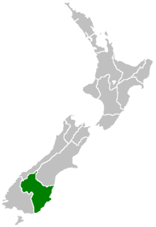
Otago Regional Council (ORC) is the regional council
Regional Council
Regional Council or regional council may refer to the following:*Regional Council *Regional Council, Hong Kong*Regional council *Regional Council - the Parliament of a Regione of Italy*Regional councils in New Zealand...
for the Otago
Otago
Otago is a region of New Zealand in the south of the South Island. The region covers an area of approximately making it the country's second largest region. The population of Otago is...
region in the South Island
South Island
The South Island is the larger of the two major islands of New Zealand, the other being the more populous North Island. It is bordered to the north by Cook Strait, to the west by the Tasman Sea, to the south and east by the Pacific Ocean...
of New Zealand
New Zealand
New Zealand is an island country in the south-western Pacific Ocean comprising two main landmasses and numerous smaller islands. The country is situated some east of Australia across the Tasman Sea, and roughly south of the Pacific island nations of New Caledonia, Fiji, and Tonga...
. The council's principal office is Regional House on Stafford Street in Dunedin
Dunedin
Dunedin is the second-largest city in the South Island of New Zealand, and the principal city of the Otago Region. It is considered to be one of the four main urban centres of New Zealand for historic, cultural, and geographic reasons. Dunedin was the largest city by territorial land area until...
, with smaller offices in Queenstown and Alexandra.
The council is a major sponsor of the Otago Regional Rescue Helicopter
Otago Regional Rescue Helicopter
The Otago Rescue Helicopter trust is an emergency helicopter service covering the lower South Island area of New Zealand, used for accident and medical air ambulance missions, and search and rescue. , the service operates a MBB/Kawasaki BK 117 B-2 helicopter, with two other BK 117s as backup to the...
.
External links
- Otago Regional Council
- localcouncils.govt.nz (Department of Internal Affairs) - Otago Regional Council information