

Orting, Washington
Encyclopedia
Orting is a city in Pierce County
, Washington, United States
. The population as of the 2010 census is 6,746, according to the City of Orting.
. The first recorded claims for the land in Orting were made in 1854 by William Henry Whitesell (also the first postmaster), Thomas Headley, Daniel Lane and Daniel Varner. These 4 people all have streets in the city named after them, plus a monument in the Orting City Park commemorating them. The city was officially incorporated on April 22, 1889. Early growth came as the area developed fields to grow hops, produce, and logging industries. Later Christmas tree and bulb farms became important to the local economy. Orting was also a supply town for the coal mining towns of Wilkeson
and Carbonado
. The first railroad in the city was built in 1877. It was called "Whitesell's Crossing" because the railroad ran right through the Whitesell property. Population rose quickly after this railroad was built, as it made transportation in and out of the city much easier. What's left of the Railroad is now the Meeker Southern Railroad
which runs between Puyallup
and McMillin
.
, is filled with a history of our nation with gravestones for soldiers dating back to service in the Civil War
. The Soldiers Home is located on the Orting Kapowsin Hwy and can be reached by leaving Orting on Calistoga and heading toward Graham where it can be found at the base of the hill.
, Puyallup
, and Sumner
.
 The town sits in a fertile valley between two major rivers, the Carbon
and Puyallup River
s, and it is built entirely on several layers of lahar
deposits. Based on past lahar flow and the structure of Mount Rainier, Orting has been designated the most at-risk town in the event of lahar activity from the mountain. Scientists predict that lahars could reach Orting in as little as 30 minutes from origin. Authorities have installed a system of lahar sirens
throughout the area, activated by sensors on Mt. Rainier. The local schools regularly stage lahar evacuation drills, and residents have been informed as to lahar escape routes. The city is progressing toward building "Bridge for Kids", a walking bridge across the Carbon River that could be used for recreation and rapid evacuation up the hill toward Cascadia.
According to the United States Census Bureau
, the city has a total area of 2.7 square miles (7.1 km²), all land.
. There is also an Orting bus, called the Orting Loop, that provides bus transportation between Orting and Puyallup, Washington
.
of 2000, there were 3,760 people, 1,318 households, and 999 families residing in the city. The population density
was 1,372.2 people per square mile (529.8/km²). There were 1,382 housing units at an average density of 504.4 per square mile (194.7/km²). The racial makeup of the city was 92.37% White, 0.61% African American, 0.98% Native American, 1.25% Asian, 0.27% Pacific Islander, 1.28% from other races, and 3.24% from two or more races. Hispanic or Latino of any race were 3.43% of the population.
There were 1,318 households out of which 44.4% had children under the age of 18 living with them, 60.5% were married couples
living together, 10.7% had a female householder with no husband present, and 24.2% were non-families. 18.7% of all households were made up of individuals and 7.4% had someone living alone who was 65 years of age or older. The average household size was 2.85 and the average family size was 3.26.
In the city the population was spread out with 32.8% under the age of 18, 7.3% from 18 to 24, 36.8% from 25 to 44, 14.4% from 45 to 64, and 8.8% who were 65 years of age or older. The median age was 30 years. For every 100 females there were 103.6 males. For every 100 females age 18 and over, there were 95.4 males.
The median income for a household in the city was $53,464, and the median income for a family was $55,335. Males had a median income of $41,486 versus $26,438 for females. The per capita income
for the city was $18,951. About 4.2% of families and 6.5% of the population were below the poverty line, including 5.2% of those under the age of 18 and 15.8% of those 65 and older.
Pierce County, Washington
right|thumb|[[Tacoma, Washington|Tacoma]] - Seat of Pierce CountyPierce County is the second most populous county in the U.S. state of Washington. Formed out of Thurston County on December 22, 1852, by the legislature of Oregon Territory...
, Washington, United States
United States
The United States of America is a federal constitutional republic comprising fifty states and a federal district...
. The population as of the 2010 census is 6,746, according to the City of Orting.
History
Orting is a small city located approximately 30 miles (48 km) from Mount RainierMount Rainier
Mount Rainier is a massive stratovolcano located southeast of Seattle in the state of Washington, United States. It is the most topographically prominent mountain in the contiguous United States and the Cascade Volcanic Arc, with a summit elevation of . Mt. Rainier is considered one of the most...
. The first recorded claims for the land in Orting were made in 1854 by William Henry Whitesell (also the first postmaster), Thomas Headley, Daniel Lane and Daniel Varner. These 4 people all have streets in the city named after them, plus a monument in the Orting City Park commemorating them. The city was officially incorporated on April 22, 1889. Early growth came as the area developed fields to grow hops, produce, and logging industries. Later Christmas tree and bulb farms became important to the local economy. Orting was also a supply town for the coal mining towns of Wilkeson
Wilkeson
Wilkeson can refer to:* Frank Wilkeson, American journalist and explorer* Leon Wilkeson, the bass guitarist of the band Lynyrd Skynyrd* Wilkeson a town in Washington State hamed for Frank Wilkeson...
and Carbonado
Carbonado
Carbonado, commonly known as the "Black Diamond", is a natural polycrystalline diamond found in alluvial deposits in the Central African Republic and Brazil. Its natural colour is black or dark grey, and it is more porous than other diamonds....
. The first railroad in the city was built in 1877. It was called "Whitesell's Crossing" because the railroad ran right through the Whitesell property. Population rose quickly after this railroad was built, as it made transportation in and out of the city much easier. What's left of the Railroad is now the Meeker Southern Railroad
Meeker Southern Railroad
The Meeker Southern Railroad is a shortline railroad owned by the Ballard Terminal Railroad that travels from Puyallup to McMillin, Washington, United States. Approximately five miles long, the Meeker Southern runs on former NP/BNSF tracks.-References:...
which runs between Puyallup
Puyallup
Puyallup may refer to:* Puyallup, Washington* Puyallup River* Puyallup , a Native American tribe* The Puyallup Fair, formerly named the "Western Washington Fair," held in Puyallup, Washington...
and McMillin
Foothills Trail
The Foothills Trail is a paved trail built on the old railroad bed. It runs through Orting, to South Prairie in one direction and to Sumner in the other. Its primary function is recreation, however it is also utilized by many commuters on bicycles. The trail is for walking, bicycling, horseback riding, skating and skateboarding and scooter traffic. It is set aside for nonmotorized vehicles only.Salmon fishing
Orting is nestled between the Carbon and Puyallup Rivers. The Voights Creek Hatchery is located just outside of Orting and plays a large part in the healthy runs of salmon that bring fishermen from far and wide to enjoy the challenge of landing a big salmonSalmon
Salmon is the common name for several species of fish in the family Salmonidae. Several other fish in the same family are called trout; the difference is often said to be that salmon migrate and trout are resident, but this distinction does not strictly hold true...
.
Washington State Soldiers Home
Orting is home to the beautiful historic buildings and park like grounds that facilitate all levels of care and housing for soldiers. The soldiers cemetery, on the hill just above the Soldiers HomeOld soldiers' home
An old soldiers' home is a military veteran's retirement home, nursing home, or hospital, or sometimes even an institution for the care of the widows and orphans of a nation's soldiers, sailors, and marines, etc.-United States:...
, is filled with a history of our nation with gravestones for soldiers dating back to service in the Civil War
American Civil War
The American Civil War was a civil war fought in the United States of America. In response to the election of Abraham Lincoln as President of the United States, 11 southern slave states declared their secession from the United States and formed the Confederate States of America ; the other 25...
. The Soldiers Home is located on the Orting Kapowsin Hwy and can be reached by leaving Orting on Calistoga and heading toward Graham where it can be found at the base of the hill.
City parks and murals
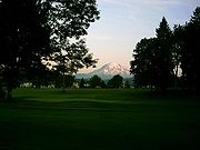
Orting is known for its beautiful parks filled with huge shade trees making it a place for picnics and relaxing right in the center of the historic downtown area. Visitors will enjoy the Saturday Market in the North Park, 9 am – 2 pm in July and August. A walking tour map is available at the library on the corner of Train and Washington. The map shows the route to the historic murals scattered on buildings throughout the town. Throughout town there are views of Mt. Rainier shining in the distance.Daffodil Parade
Every year, Orting is the fourth and final stop in the annual Daffodil Festival Parade. The parade has gone through downtown Orting since 1934. It draws over 10,000 people in early April to the festivities in the downtown Orting Parks and the parade viewing in late afternoon. The parade also goes through the cities of TacomaTacoma, Washington
Tacoma is a mid-sized urban port city and the county seat of Pierce County, Washington, United States. The city is on Washington's Puget Sound, southwest of Seattle, northeast of the state capital, Olympia, and northwest of Mount Rainier National Park. The population was 198,397, according to...
, Puyallup
Puyallup, Washington
Puyallup, Washington is a city in Pierce County, Washington about five miles east of Tacoma. The population was 37,022 at the 2010 Census. Named after the Puyallup Tribe of Native Americans, Puyallup means "the generous people."-History:...
, and Sumner
Sumner, Washington
Sumner is a city in northern Pierce County, Washington, United States. The population was 9,451 at the 2010 census. Nearby cities include Puyallup to the west, Auburn to the north, and Enumclaw to the east.-History:...
.
Mount Rainier
Carbon River
The Carbon River is a river in the U.S. state of Washington. It flows about 30 miles from its source, the Carbon Glacier on Mount Rainier, to join the Puyallup River at Orting....
and Puyallup River
Puyallup River
The Puyallup River is a river in the U.S. state of Washington. About long, it is formed by glaciers on the west side of Mount Rainier. It flows generally northwest, emptying into Commencement Bay, part of Puget Sound...
s, and it is built entirely on several layers of lahar
Lahar
A lahar is a type of mudflow or debris flow composed of a slurry of pyroclastic material, rocky debris, and water. The material flows down from a volcano, typically along a river valley. The term is a shortened version of "berlahar" which originated in the Javanese language of...
deposits. Based on past lahar flow and the structure of Mount Rainier, Orting has been designated the most at-risk town in the event of lahar activity from the mountain. Scientists predict that lahars could reach Orting in as little as 30 minutes from origin. Authorities have installed a system of lahar sirens
Mount Rainier Volcano Lahar Warning System
The Mount Rainier Volcano Lahar Warning System is a loose-knit, emergency notification and warning system developed by the United States Geological Survey in 1998, and now operated by the Pierce County Department of Emergency Management and several cities...
throughout the area, activated by sensors on Mt. Rainier. The local schools regularly stage lahar evacuation drills, and residents have been informed as to lahar escape routes. The city is progressing toward building "Bridge for Kids", a walking bridge across the Carbon River that could be used for recreation and rapid evacuation up the hill toward Cascadia.
Geography
Orting is located at 47°5′46"N 122°12′19"W (47.096071, -122.205401).According to the United States Census Bureau
United States Census Bureau
The United States Census Bureau is the government agency that is responsible for the United States Census. It also gathers other national demographic and economic data...
, the city has a total area of 2.7 square miles (7.1 km²), all land.
Transportation
The primary way of reaching the city by car is Washington State Route 162Washington State Route 162
State Route 162 is a long state highway located entirely in Pierce County, Washington, United States.- Route description :...
. There is also an Orting bus, called the Orting Loop, that provides bus transportation between Orting and Puyallup, Washington
Puyallup, Washington
Puyallup, Washington is a city in Pierce County, Washington about five miles east of Tacoma. The population was 37,022 at the 2010 Census. Named after the Puyallup Tribe of Native Americans, Puyallup means "the generous people."-History:...
.
Education
Education in the city of Orting is provided by the Orting School District. There are currently 5 schools in operation.- Orting Primary School (grades K–2)
- Ptarmigan Ridge Intermediate School (grades 3–5)
- Orting Middle School (grades 6–8)
- Orting High SchoolOrting High SchoolOrting High School is a high school located in Orting, Washington that serves students from grades 9-12 in the Orting and surrounding areas. The mascot is the Cardinal, and the Orting Cardinals are a member of the Nisqually League.-Layout:...
(grades 9–12)
Demographics
As of the censusCensus
A census is the procedure of systematically acquiring and recording information about the members of a given population. It is a regularly occurring and official count of a particular population. The term is used mostly in connection with national population and housing censuses; other common...
of 2000, there were 3,760 people, 1,318 households, and 999 families residing in the city. The population density
Population density
Population density is a measurement of population per unit area or unit volume. It is frequently applied to living organisms, and particularly to humans...
was 1,372.2 people per square mile (529.8/km²). There were 1,382 housing units at an average density of 504.4 per square mile (194.7/km²). The racial makeup of the city was 92.37% White, 0.61% African American, 0.98% Native American, 1.25% Asian, 0.27% Pacific Islander, 1.28% from other races, and 3.24% from two or more races. Hispanic or Latino of any race were 3.43% of the population.
There were 1,318 households out of which 44.4% had children under the age of 18 living with them, 60.5% were married couples
Marriage
Marriage is a social union or legal contract between people that creates kinship. It is an institution in which interpersonal relationships, usually intimate and sexual, are acknowledged in a variety of ways, depending on the culture or subculture in which it is found...
living together, 10.7% had a female householder with no husband present, and 24.2% were non-families. 18.7% of all households were made up of individuals and 7.4% had someone living alone who was 65 years of age or older. The average household size was 2.85 and the average family size was 3.26.
In the city the population was spread out with 32.8% under the age of 18, 7.3% from 18 to 24, 36.8% from 25 to 44, 14.4% from 45 to 64, and 8.8% who were 65 years of age or older. The median age was 30 years. For every 100 females there were 103.6 males. For every 100 females age 18 and over, there were 95.4 males.
The median income for a household in the city was $53,464, and the median income for a family was $55,335. Males had a median income of $41,486 versus $26,438 for females. The per capita income
Per capita income
Per capita income or income per person is a measure of mean income within an economic aggregate, such as a country or city. It is calculated by taking a measure of all sources of income in the aggregate and dividing it by the total population...
for the city was $18,951. About 4.2% of families and 6.5% of the population were below the poverty line, including 5.2% of those under the age of 18 and 15.8% of those 65 and older.